Texas Winter 2013-2014

Winter Weather Discussion

Moderator: S2k Moderators

Forum rules

The posts in this forum are NOT official forecast and should not be used as such. They are just the opinion of the poster and may or may not be backed by sound meteorological data. They are NOT endorsed by any professional institution or STORM2K.

Help Support Storm2K
Message
Author
User avatar
srainhoutx
S2K Supporter
S2K Supporter
Posts: 6919
Age: 68
Joined: Sun Jan 14, 2007 11:34 am
Location: Haywood County, NC
Contact:

Re: Texas Winter 2013-2014

#4101 Postby srainhoutx » Tue Jan 21, 2014 10:00 am

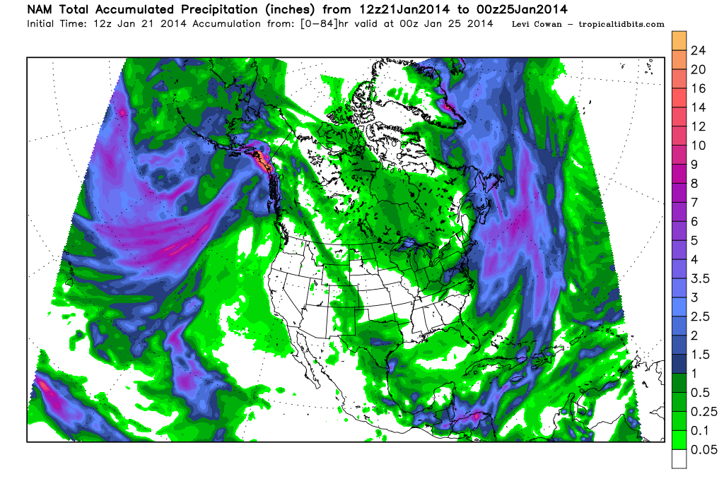
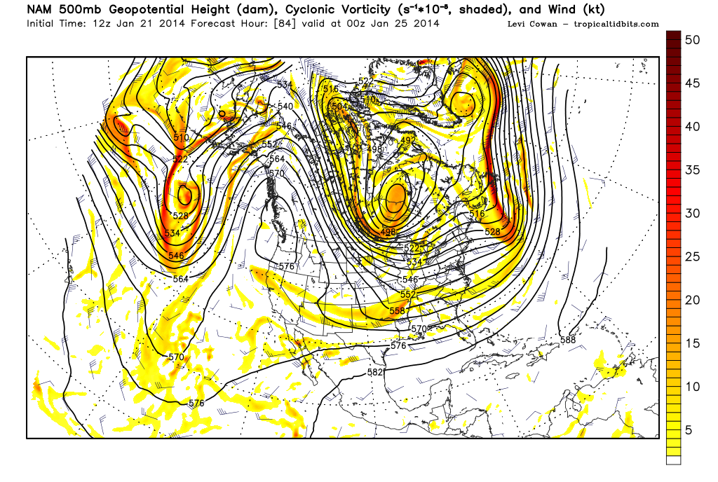
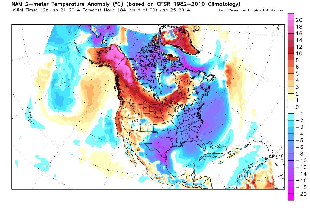
The 12Z NAM is considerably 'wetter' than the 06Z run. The 12Z NAM is also suggesting a bit stronger upper air disturbance and that old Coastal trough is back once again. The NAM also keep the precip going longer into Friday since it has slowed the progression of that upper air disturbance by about 6-12 hours. The Arctic front still arrives late Wednesday and makes it to the Coast By mid day Thursday and has a bit stronger 1044mb High pressure cell associated with the cold air.

Image

Image

Image
0 likes   
Carla/Alicia/Jerry(In The Eye)/Michelle/Charley/Ivan/Dennis/Katrina/Rita/Wilma/Ike/Harvey

Member: National Weather Association
Wx Infinity Forums
http://wxinfinity.com/index.php

Facebook.com/WeatherInfinity
Twitter @WeatherInfinity

User avatar
TheProfessor
Professional-Met
Professional-Met
Posts: 3506
Age: 29
Joined: Tue Dec 03, 2013 10:56 am
Location: Wichita, Kansas

Re: Texas Winter 2013-2014

#4102 Postby TheProfessor » Tue Jan 21, 2014 10:05 am

srainhoutx wrote:The 12Z NAM is considerably 'wetter' than the 06Z run. The 12Z NAM is also suggesting a bit stronger upper air disturbance and that old Coastal trough is back once again. The NAM also keep the precip going longer into Friday since it has slowed the progression of that upper air disturbance by about 6-12 hours. The Arctic front still arrives late Wednesday and makes it to the Coast By mid day Thursday and has a bit stronger 1044mb High pressure cell associated with the cold air.

Image

Image

Image


Is this liquid or frozen precipitation?
0 likes   
An alumnus of The Ohio State University.

Your local National Weather Service office is your best source for weather information.

User avatar
srainhoutx
S2K Supporter
S2K Supporter
Posts: 6919
Age: 68
Joined: Sun Jan 14, 2007 11:34 am
Location: Haywood County, NC
Contact:

Re: Texas Winter 2013-2014

#4103 Postby srainhoutx » Tue Jan 21, 2014 10:07 am

TheProfessor wrote:
Is this liquid or frozen precipitation?

It's way too soon to worry about those 'finer' details' and particularly concerning the NAM short range meso guidance beyond 48 hours.
0 likes   
Carla/Alicia/Jerry(In The Eye)/Michelle/Charley/Ivan/Dennis/Katrina/Rita/Wilma/Ike/Harvey

Member: National Weather Association
Wx Infinity Forums
http://wxinfinity.com/index.php

Facebook.com/WeatherInfinity
Twitter @WeatherInfinity

User avatar
TeamPlayersBlue
Category 5
Category 5
Posts: 3462
Joined: Tue Feb 02, 2010 1:44 am
Location: Denver/Applewood, CO

Re: Texas Winter 2013-2014

#4104 Postby TeamPlayersBlue » Tue Jan 21, 2014 10:10 am

srainhoutx wrote:
TheProfessor wrote:
Is this liquid or frozen precipitation?

It's way too soon to worry about those 'finer' details' and particularly concerning the NAM short range meso guidance beyond 48 hours.


Yeah, at this point we need to ake sure we have the moisture :) Everything else will play itself out when the moisture comes on board
0 likes   
Personal Forecast Disclaimer:
The posts in this forum are NOT official forecast and should not be used as such. They are just the opinion of the poster and may or may not be backed by sound meteorological data. They are NOT endorsed by any professional institution or storm2k.org. For official information, please refer to the NHC and NWS products.

User avatar
Portastorm
Storm2k Moderator
Storm2k Moderator
Posts: 9914
Age: 63
Joined: Fri Jul 11, 2003 9:16 am
Location: Round Rock, TX
Contact:

Re: Texas Winter 2013-2014

#4105 Postby Portastorm » Tue Jan 21, 2014 10:15 am

I'm loving the 12z NAM. Loving it! :cheesy:

That run has a ++PWC/--WSI index

By the way, the Portastorm Weather Center has scheduled a news conference for 4 p.m. tomorrow (Wednesday). Storm2k News will cover the event.
0 likes   
Any forecasts under my name are to be taken with a grain of salt. Get your best forecasts from the National Weather Service and National Hurricane Center.

User avatar
Tireman4
S2K Supporter
S2K Supporter
Posts: 5858
Age: 60
Joined: Fri Jun 30, 2006 1:08 pm
Location: Humble, Texas
Contact:

Re: Texas Winter 2013-2014

#4106 Postby Tireman4 » Tue Jan 21, 2014 10:16 am

Portastorm wrote:I'm loving the 12z NAM. Loving it! :cheesy:

That run has a ++PWC/--WSI index

[b]By the way, the Portastorm Weather Center has scheduled a news conference for 4 p.m. tomorrow (Wednesday). Storm2k News will cover the event.[/b]


Thank goodness. That is the only news source I trust in weather. :)
0 likes   

User avatar
TheProfessor
Professional-Met
Professional-Met
Posts: 3506
Age: 29
Joined: Tue Dec 03, 2013 10:56 am
Location: Wichita, Kansas

Re: Texas Winter 2013-2014

#4107 Postby TheProfessor » Tue Jan 21, 2014 10:17 am

TeamPlayersBlue wrote:
srainhoutx wrote:
TheProfessor wrote:
Is this liquid or frozen precipitation?

It's way too soon to worry about those 'finer' details' and particularly concerning the NAM short range meso guidance beyond 48 hours.


Yeah, at this point we need to ake sure we have the moisture :) Everything else will play itself out when the moisture comes on board


Ok, I was just wondering because close to an inch of rain is a lot different than close to an inch of snow when you convert the rain into snow. :D
0 likes   
An alumnus of The Ohio State University.

Your local National Weather Service office is your best source for weather information.

User avatar
ThunderSleetDreams
S2K Supporter
S2K Supporter
Posts: 1477
Age: 43
Joined: Tue Dec 20, 2011 4:42 pm
Location: S of Weimar, TX

Re: Texas Winter 2013-2014

#4108 Postby ThunderSleetDreams » Tue Jan 21, 2014 10:20 am

Yeah, at this point we need to ake sure we have the moisture :) Everything else will play itself out when the moisture comes on board


Ok, I was just wondering because close to an inch of rain is a lot different than close to an inch of snow when you convert the rain into snow. :D


1 inch of liquid to snow using the standard rule is 10 inches of snow. .2 inches of liquid is 2 inches of snow.
Last edited by ThunderSleetDreams on Tue Jan 21, 2014 10:24 am, edited 1 time in total.
0 likes   
#NeverSummer

I hibernate when it gets above 75 degrees!

gpsnowman
S2K Supporter
S2K Supporter
Posts: 3215
Joined: Fri Jan 07, 2011 10:35 am
Location: Grand Prairie Tx

#4109 Postby gpsnowman » Tue Jan 21, 2014 10:22 am

Awesome!!! A PWC news conference is always good. Porta, maybe you could nudge a little moisture up DFWs way. I don't mean to sound greedy but......I am. :D
0 likes   

User avatar
Tireman4
S2K Supporter
S2K Supporter
Posts: 5858
Age: 60
Joined: Fri Jun 30, 2006 1:08 pm
Location: Humble, Texas
Contact:

#4110 Postby Tireman4 » Tue Jan 21, 2014 10:24 am

Oh look what I found rummaging through the archives. This brings back memories of an event four days out....December 2009...Houston (HGX). Enjoy...


Well HGX is getting a bit more bullish on the event...

IT SEEMS THAT YESTERDAY`S 12Z GFS RUN PICKED UP ON A STRONG
SHORTWAVE TROUGH THAT IT HAD NOT PREVIOUSLY RESOLVED. THE
SHORTWAVE IS NOW OVER THE PAC NW THAT WILL MOVE THROUGH THE AREA
ON FRI AS A STRONG JET STREAK PUSHES INTO IT ON THU. TODAY`S 12Z
GFS CONTINUES THIS TREND AS DOES THE 12Z NAM. THIS BRINGS MORE
CONFIDENCE TO FORECAST WINTER PRECIPITATION DURING THE DAY FRI.
THE EVENT MAY BE 4 DAYS OUT BUT WILL DO THE BEST TO HASH OUT
DETAILS OF THE TRANSITION FROM RAIN TO SNOW AS MODEL SOUNDINGS
SUPPORT ALL SNOW BY THE AFTERNOON AS WELL AS ANY HEAVIER PRECIP
BANDS. THE NEW HAZARDOUS WEATHER OUTLOOK WILL DETAIL OUR LATEST
THINKING BUT WILL BE UPDATED AGAIN THIS AFTERNOON. AFTERNOON
FORECAST PACKAGE WILL ALSO FEATURE AN SPS TO OUTLINE WINTER
PRECIP THREATS/HAZARDS AND TIMING OF THE EVENT FOR AREAS OF SE TX.
0 likes   

User avatar
Big O
Category 1
Category 1
Posts: 252
Age: 55
Joined: Sun Sep 16, 2007 4:40 pm
Location: McAllen, Texas

Re: Texas Winter 2013-2014

#4111 Postby Big O » Tue Jan 21, 2014 10:25 am

Portastorm wrote:I'm loving the 12z NAM. Loving it! :cheesy:

That run has a ++PWC/--WSI index

By the way, the Portastorm Weather Center has scheduled a news conference for 4 p.m. tomorrow (Wednesday). Storm2k News will cover the event.


I can see why. Looks like a good 2-6" for PWC-Austin branch. Let's see what the GFS and Euro have to say at 12z before we get ahead of ourselves.
0 likes   

User avatar
ThunderSleetDreams
S2K Supporter
S2K Supporter
Posts: 1477
Age: 43
Joined: Tue Dec 20, 2011 4:42 pm
Location: S of Weimar, TX

Re: Texas Winter 2013-2014

#4112 Postby ThunderSleetDreams » Tue Jan 21, 2014 10:29 am

If I can just get an inch of sleet in MoCo, I'll be happy.
0 likes   
#NeverSummer

I hibernate when it gets above 75 degrees!

User avatar
Ntxw
Storm2k Moderator
Storm2k Moderator
Posts: 22898
Joined: Wed Oct 21, 2009 6:34 pm
Location: DFW, Texas

Re: Texas Winter 2013-2014

#4113 Postby Ntxw » Tue Jan 21, 2014 10:30 am

Portastorm wrote:I'm loving the 12z NAM. Loving it! :cheesy:

That run has a ++PWC/--WSI index

By the way, the Portastorm Weather Center has scheduled a news conference for 4 p.m. tomorrow (Wednesday). Storm2k News will cover the event.


Absolutely love the WSI tank! The NTX PWC branch will be making the trip for the conference providing state of the art, colorful charts, graphs, and maps for an unparalleled visual experience (2d, 3d, and 4d). Currently picket signs are being made of anti-heat miser for all who attend.
0 likes   
The above post and any post by Ntxw is NOT an official forecast and should not be used as such. It is just the opinion of the poster and may or may not be backed by sound meteorological data. It is NOT endorsed by any professional institution including Storm2k. For official information, please refer to NWS products.

  Help support Storm2K!
Help Support Storm2K

Ralph's Weather
S2K Supporter
S2K Supporter
Posts: 3279
Age: 38
Joined: Fri Dec 13, 2013 11:55 am
Location: Lindale, TX
Contact:

#4114 Postby Ralph's Weather » Tue Jan 21, 2014 10:30 am

I am sticking with the idea of a low forming in the Gulf and spreading snow between I-10 and I-20 in Texas and maybe further east. I could easily see how this storm could lay down a decent band on its northern periphery before it moves east along the Gulf coast.
0 likes   
Follow on Facebook at Ralph's Weather.

User avatar
TeamPlayersBlue
Category 5
Category 5
Posts: 3462
Joined: Tue Feb 02, 2010 1:44 am
Location: Denver/Applewood, CO

Re:

#4115 Postby TeamPlayersBlue » Tue Jan 21, 2014 10:31 am

Tireman4 wrote:Oh look what I found rummaging through the archives. This brings back memories of an event four days out....December 2009...Houston (HGX). Enjoy...


Well HGX is getting a bit more bullish on the event...

IT SEEMS THAT YESTERDAY`S 12Z GFS RUN PICKED UP ON A STRONG
SHORTWAVE TROUGH THAT IT HAD NOT PREVIOUSLY RESOLVED. THE
SHORTWAVE IS NOW OVER THE PAC NW THAT WILL MOVE THROUGH THE AREA
ON FRI AS A STRONG JET STREAK PUSHES INTO IT ON THU. TODAY`S 12Z
GFS CONTINUES THIS TREND AS DOES THE 12Z NAM. THIS BRINGS MORE
CONFIDENCE TO FORECAST WINTER PRECIPITATION DURING THE DAY FRI.
THE EVENT MAY BE 4 DAYS OUT BUT WILL DO THE BEST TO HASH OUT
DETAILS OF THE TRANSITION FROM RAIN TO SNOW AS MODEL SOUNDINGS
SUPPORT ALL SNOW BY THE AFTERNOON AS WELL AS ANY HEAVIER PRECIP
BANDS. THE NEW HAZARDOUS WEATHER OUTLOOK WILL DETAIL OUR LATEST
THINKING BUT WILL BE UPDATED AGAIN THIS AFTERNOON. AFTERNOON
FORECAST PACKAGE WILL ALSO FEATURE AN SPS TO OUTLINE WINTER
PRECIP THREATS/HAZARDS AND TIMING OF THE EVENT FOR AREAS OF SE TX.


The exact event that came to mind when i saw we have a possibility of frozen precip coming. It popped up 4 days in advance and it snowed that Friday for quite some time. That was all snow though. Even as i drove into work, they expected alot more sleet and rain before the snow came. Snow came much earlier than expected. Atmosphere cooled down rapidly.
0 likes   
Personal Forecast Disclaimer:
The posts in this forum are NOT official forecast and should not be used as such. They are just the opinion of the poster and may or may not be backed by sound meteorological data. They are NOT endorsed by any professional institution or storm2k.org. For official information, please refer to the NHC and NWS products.

User avatar
ThunderSleetDreams
S2K Supporter
S2K Supporter
Posts: 1477
Age: 43
Joined: Tue Dec 20, 2011 4:42 pm
Location: S of Weimar, TX

Re: Texas Winter 2013-2014

#4116 Postby ThunderSleetDreams » Tue Jan 21, 2014 10:34 am

Ntxw wrote:
Portastorm wrote:I'm loving the 12z NAM. Loving it! :cheesy:

That run has a ++PWC/--WSI index

By the way, the Portastorm Weather Center has scheduled a news conference for 4 p.m. tomorrow (Wednesday). Storm2k News will cover the event.


Absolutely love the WSI tank! The NTX PWC branch will be making the trip for the conference providing state of the art, colorful charts, graphs, and maps for an unparalleled visual experience (2d, 3d, and 4d). Currently picket signs are being made of anti-heat miser for all who attend.


Mine says "Heat is for the birds... and communists!"
0 likes   
#NeverSummer

I hibernate when it gets above 75 degrees!

stormlover2013

Re: Texas Winter 2013-2014

#4117 Postby stormlover2013 » Tue Jan 21, 2014 10:38 am

this is going to be a tough tough forecast for the gurus!!!!!
0 likes   

User avatar
HouTXmetro
Category 5
Category 5
Posts: 3949
Joined: Sun Jun 13, 2004 6:00 pm
Location: District of Columbia, USA

Re: Texas Winter 2013-2014

#4118 Postby HouTXmetro » Tue Jan 21, 2014 10:40 am

Regarding the Euro somewhat drying out, doesn't past experience tell us that the models tend to lose the event a few days prior then pops right back up like a day or two before?
0 likes   
[Disclaimer: My Amateur Opinion, please defer to your local authorities or the NHC for Guidance.]

User avatar
TheProfessor
Professional-Met
Professional-Met
Posts: 3506
Age: 29
Joined: Tue Dec 03, 2013 10:56 am
Location: Wichita, Kansas

#4119 Postby TheProfessor » Tue Jan 21, 2014 10:42 am

Is the 12:00 gfs out yet?
0 likes   
An alumnus of The Ohio State University.

Your local National Weather Service office is your best source for weather information.

stormlover2013

Re: Texas Winter 2013-2014

#4120 Postby stormlover2013 » Tue Jan 21, 2014 10:47 am

running now!!!
0 likes   


Return to “Winter Weather”

Who is online

Users browsing this forum: No registered users and 56 guests