Yeah tonight's 0z NAM looks good across much of central Texas. The 21z SREF also trended wetter across central Texas.
Texas Winter 2013-2014
Moderator: S2k Moderators
Forum rules
 The posts in this forum are NOT official forecast and should not be used as such. They are just the opinion of the poster and may or may not be backed by sound meteorological data. They are NOT endorsed by any professional institution or STORM2K.

The posts in this forum are NOT official forecast and should not be used as such. They are just the opinion of the poster and may or may not be backed by sound meteorological data. They are NOT endorsed by any professional institution or STORM2K.
-
South Texas Storms

- Professional-Met

- Posts: 4257
- Joined: Thu Jun 24, 2010 12:28 am
- Location: Houston, TX
Re: Texas Winter 2013-2014
Yeah tonight's 0z NAM looks good across much of central Texas. The 21z SREF also trended wetter across central Texas.
0 likes
-
HouTXmetro

- Category 5

- Posts: 3949
- Joined: Sun Jun 13, 2004 6:00 pm
- Location: District of Columbia, USA
Re: Texas Winter 2013-2014
Can you post a graphic?
0 likes
[Disclaimer: My Amateur Opinion, please defer to your local authorities or the NHC for Guidance.]
-
Rgv20

- S2K Supporter

- Posts: 2466
- Age: 39
- Joined: Wed Jan 05, 2011 5:42 pm
- Location: Edinburg/McAllen Tx
Looking at the 0zNAM Meteogram it keeps my area in the low 30s all day Friday and by the looks of the Forecast Skew T it looks like Sleet is a real possibility and if temperatures drop below freezing Freezing Rain will be a threat. GFS and ECMWF are much warmer for my area with high temperatures eventually reaching the low 40s with lows Friday morning right around 34-35. Interesting days ahead!
0 likes
The following post is NOT an official forecast and should not be used as such. It is just the opinion of the poster and may or may not be backed by sound meteorological data. It is NOT endorsed by any professional institution including storm2k.org For Official Information please refer to the NHC and NWS products.
-
stormlover2013
Re: Texas Winter 2013-2014
Guys remember it's the nam lol, one model u don't trust. Let's see what the gfs says tonight
0 likes


Re: Texas Winter 2013-2014
Here's the NAM.

GFS is kind of similar, mostly Edwards Plateau/Permian basin/Big country ordeal in terms of measurable snow. Does not include sleet and or freezing rain. Both seem to like Midland-Big Spring-San Angelo<-hello natlib-Brownwood areas for snow.
GFS is kind of similar, mostly Edwards Plateau/Permian basin/Big country ordeal in terms of measurable snow. Does not include sleet and or freezing rain. Both seem to like Midland-Big Spring-San Angelo<-hello natlib-Brownwood areas for snow.
0 likes
The above post and any post by Ntxw is NOT an official forecast and should not be used as such. It is just the opinion of the poster and may or may not be backed by sound meteorological data. It is NOT endorsed by any professional institution including Storm2k. For official information, please refer to NWS products.
Help support Storm2K!
-
orangeblood
- S2K Supporter
- Posts: 3895
- Joined: Tue Dec 15, 2009 6:14 pm
- Location: Fort Worth, TX
Re: Texas Winter 2013-2014
GFS does have a little more areal coverage of precip compared to past runs, seems to keep more of the upper level energy intact. A little colder as well with sleet extending down I-10 corridor from San Antonio into Houston Metro. Going to be a lot of Virga with this system, especially the further north and east you are
Last edited by orangeblood on Tue Jan 21, 2014 11:15 pm, edited 1 time in total.
0 likes
-
HouTXmetro
- Category 5
- Posts: 3949
- Joined: Sun Jun 13, 2004 6:00 pm
- Location: District of Columbia, USA
Re: Texas Winter 2013-2014
Why is the Heavier stuff north and west? I though the moisture was suppose stream in from the Gulf?
Last edited by HouTXmetro on Tue Jan 21, 2014 11:20 pm, edited 1 time in total.
0 likes
[Disclaimer: My Amateur Opinion, please defer to your local authorities or the NHC for Guidance.]
-
South Texas Storms
- Professional-Met
- Posts: 4257
- Joined: Thu Jun 24, 2010 12:28 am
- Location: Houston, TX
Re: Texas Winter 2013-2014
I think the 0z NAM is showing up to 2-3 inches of sleet across Austin and San Antonio on it's snow forecast map from WxBell.
0 likes
-
orangeblood
- S2K Supporter
- Posts: 3895
- Joined: Tue Dec 15, 2009 6:14 pm
- Location: Fort Worth, TX
Re: Texas Winter 2013-2014
HouTXmetro wrote:Why is the Heavier stuff north and west? I though the moisture was suppose stream in from in for Gulf?
Dry Air, dew points are approaching single digits in southeast Texas as the bulk of the precip is moving that direction
0 likes
-
gboudx

- S2K Supporter
- Posts: 4090
- Joined: Thu Sep 04, 2003 1:39 pm
- Location: Rockwall, Tx but from Harvey, La
Re: Texas Winter 2013-2014
JDawg512 wrote::ggreen: Alright then. The TV news stations here in Austin are forecasting snow. I'm getting pretty excited about it now that I'm seeing that.

Well looks like you got the kiss of death. It's like Fight Club; the first rule about forecasted snow in Texas is, you don't talk about forecasted snow in Texas.
0 likes
Re: Texas Winter 2013-2014
South Texas Storms wrote:I think the 0z NAM is showing up to 2-3 inches of sleet across Austin and San Antonio on it's snow forecast map from WxBell.
Probably is, based on the ice storm earlier in the season wxbell maps dont seperate snow vs sleet all mixed in it seems and sleet tends to overdo amount reflection on snow maps.
Wasn't there a similar storm/system like this last year just before New Years? I remember Austin was slated to get a good event but it turned out to be San Angelo and Midland.
0 likes
The above post and any post by Ntxw is NOT an official forecast and should not be used as such. It is just the opinion of the poster and may or may not be backed by sound meteorological data. It is NOT endorsed by any professional institution including Storm2k. For official information, please refer to NWS products.
Help support Storm2K!
Help support Storm2K!
-
South Texas Storms
- Professional-Met
- Posts: 4257
- Joined: Thu Jun 24, 2010 12:28 am
- Location: Houston, TX
Re: Texas Winter 2013-2014
Ntxw wrote:South Texas Storms wrote:I think the 0z NAM is showing up to 2-3 inches of sleet across Austin and San Antonio on it's snow forecast map from WxBell.
Probably is, based on the ice storm earlier in the season wxbell maps dont seperate snow vs sleet all mixed in it seems and sleet tends to overdo amount reflection on snow maps.
Yeah, but the main thing I'm taking from tonight's 0z runs so far is the wetter trend, with the NAM, GFS, and SREF all showing slightly more QPF across central Texas.
Next up is the CMC, UKMET, and Euro.
0 likes
Fast forward a little...we've already had 4 big ones, a decade's worth, how about another? Sure why not.

Yes, I do realize it is La La Land GFS but you have to consider it originates from Siberia and crosses over to Alaska before truncation via the well seen Aleutian ridge coming (thanks -EPO dive) early next week. Given that most big high's this year have panned out (even when models don't show it they still pan out shockingly) what's another in the books?
Yes, I do realize it is La La Land GFS but you have to consider it originates from Siberia and crosses over to Alaska before truncation via the well seen Aleutian ridge coming (thanks -EPO dive) early next week. Given that most big high's this year have panned out (even when models don't show it they still pan out shockingly) what's another in the books?
0 likes
The above post and any post by Ntxw is NOT an official forecast and should not be used as such. It is just the opinion of the poster and may or may not be backed by sound meteorological data. It is NOT endorsed by any professional institution including Storm2k. For official information, please refer to NWS products.
Help support Storm2K!
Help support Storm2K!
-
Rgv20
- S2K Supporter
- Posts: 2466
- Age: 39
- Joined: Wed Jan 05, 2011 5:42 pm
- Location: Edinburg/McAllen Tx
0zGFS Ice Pellets accumulations thru Friday Evening..
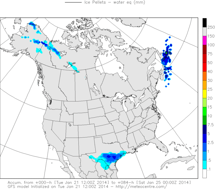
0zNAM Ice Pellets accumulations thru Friday Evening..
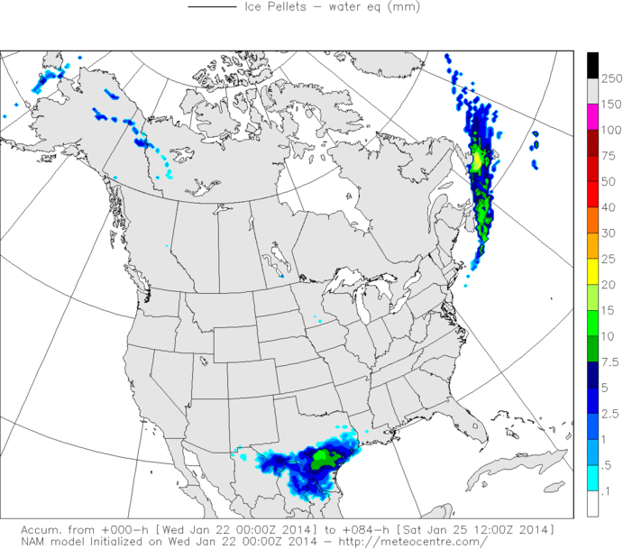

0zNAM Ice Pellets accumulations thru Friday Evening..

0 likes
The following post is NOT an official forecast and should not be used as such. It is just the opinion of the poster and may or may not be backed by sound meteorological data. It is NOT endorsed by any professional institution including storm2k.org For Official Information please refer to the NHC and NWS products.

Re: Texas Winter 2013-2014
Ntxw wrote:Here's the NAM.
GFS is kind of similar, mostly Edwards Plateau/Permian basin/Big country ordeal in terms of measurable snow. Does not include sleet and or freezing rain. Both seem to like Midland-Big Spring-San Angelo<-hello natlib-Brownwood areas for snow.
I'm liking the trend....but it is mighty dry here.....will have to really change quickly
0 likes
-
Brent
- S2K Supporter
- Posts: 38747
- Age: 37
- Joined: Sun May 16, 2004 10:30 pm
- Location: Tulsa Oklahoma
- Contact:
Re: Texas Winter 2013-2014
wxman57 can I get a meteogram for KANB now?  Clearly that run of the 60s the other day was trash
0 likes
#neversummer
-
wxman57

- Moderator-Pro Met

- Posts: 23174
- Age: 68
- Joined: Sat Jun 21, 2003 8:06 pm
- Location: Houston, TX (southwest)
Re: Texas Winter 2013-2014
Brent wrote:wxman57 can I get a meteogram for KANB now?
Yes, it looks colder now. Not a trace of precip indicated:

0 likes
-
TrekkerCC

- S2K Supporter
- Posts: 263
- Joined: Sat Sep 06, 2003 10:19 pm
- Location: North Central Texas (Dallas Area)
Re: Texas Winter 2013-2014
stormlover2013 wrote:What did the cmc And euro show?
I don't have access to the euro 00z precipitation graphics, but the CMC 00z run shows a developing coastal trough and precipitation occurs in central and southeastern parts of Texas. This precipitation includes a wintry mix. The 00z run CMC shows no precipitation for North Texas.
0 likes
Storm2K Forecast Disclaimer:
This post is NOT AN OFFICIAL FORECAST and should not be used as such. It is just the opinion of the poster and may or may not be backed by sound meteorological data. It is NOT endorsed by any professional institution including storm2k.org. For Official Information please refer to the NHC and NWS products.
This post is NOT AN OFFICIAL FORECAST and should not be used as such. It is just the opinion of the poster and may or may not be backed by sound meteorological data. It is NOT endorsed by any professional institution including storm2k.org. For Official Information please refer to the NHC and NWS products.
-
weatherdude1108
- Category 5
- Posts: 4228
- Joined: Tue Dec 13, 2011 1:04 pm
- Location: Northwest Austin/Cedar Park, TX
"MOST AREAS COULD SEE A DUSTING OF SNOW"


"Special Weather Statement in effect
WINTER PRECIPITATION AND SOME SNOW ACCUMULATION POSSIBLE ACROSS PORTIONS OF SOUTH CENTRAL TEXAS THURSDAY EVENING INTO FRIDAY
A STRONG COLD FRONT WITH AN ARCTIC AIRMASS BEHIND IT WILL SURGE ACROSS SOUTH CENTRAL TEXAS EARLY ON THURSDAY BRINGING MUCH COLDER AIR. LIGHT RAIN WILL DEVELOP DURING THE DAY. AS THE AIR CONTINUES TO COOL
WINTRY PRECIPITATION MAY DEVELOP. INITIALLY SOME SLEET WILL MIX WITH THE RAIN. AS TEMPERATURES DROP BELOW FREEZING
A MIX OF SLEET AND SNOW WILL DEVELOP THURSDAY NIGHT INTO FRIDAY MORNING. THE WINTER PRECIPITATION WILL START IN THE HILL COUNTRY LATE THURSDAY AFTERNOON AND SPREAD SOUTH THURSDAY NIGHT INTO EARLY FRIDAY. ALL PRECIPITATION WILL END FRIDAY MORNING INTO EARLY AFTERNOON. CURRENT PROJECTIONS SHOW ONLY LIGHT PRECIPITATION AMOUNTS. HOWEVER
SOME SNOW ACCUMULATION IS POSSIBLE MAINLY NORTH OF A LINE FROM DEL RIO TO SAN ANTONIO TO SCHULENBURG. NORTH OF THIS LINE
MOST AREAS COULD SEE A DUSTING OF SNOW
WITH UP TO ONE QUARTER INCH OF SNOW IN THE HILL COUNTRY. THE BEST TIME FOR ACCUMULATING WINTER PRECIPITATION WILL BE BETWEEN 6 PM THURSDAY AND 6 AM FRIDAY. THIS MAY IMPACT THE FRIDAY MORNING COMMUTES N THE AUSTIN AND SAN ANTONIO AREAS. CHECK THE FORECAST FREQUENTLY PRIOR TO AND DURING THIS POTENTIAL WINTER WEATHER EVENT AS SUBTLE CHANGES IN THE ATMOSPHERE COULD HAVE A SIGNIFICANT IMPACT ON THE FORECAST."
0 likes
The preceding post is NOT an official forecast, and should not be used as such. It is only the opinion of the poster and may or may not be backed by sound meteorological data. It is NOT endorsed by any professional institution including storm2k.org. For Official Information please refer to the NHC and NWS products.
Who is online
Users browsing this forum: No registered users and 62 guests