
A very tricky forecast remains for Thursday night through Friday as we draw closer to a possible Winter weather event for a large portion of TX. however I calling a Bear Watch at this point. Freezing rain and sleet remain a concern for Houston metro with light snow potential for the College Station area. Sleet and snow possible across the Hill Country and N portions of S Central TX. Snow and sleet threat will be S and SW of the Dallas-Ft Areas. The NWS does a great job with their AFDs. The Houston-Galveston NWS summarize the upcoming forecast very well:
THIS WILL REMAIN TRICKY AS FORECASTED THICKNESS VALUES ARE NOT ALL IN AGREEMENT. 1000 - 500MB AND 850 TO 700MB THICKNESS VALUES DO NOT INDICATE SNOW. 1000 TO 850MB THICKNESS VALUES DO GET TO 1290 AT KCLL WHICH WOULD INDICATE A CHANCE OF SNOW. A WINTER STORM WATCH OR WINTER WEATHER ADVISORIES MAY BE REQUIRED LATE THURSDAY INTO FRIDAY.
Texas Winter 2013-2014
Moderator: S2k Moderators
Forum rules
 The posts in this forum are NOT official forecast and should not be used as such. They are just the opinion of the poster and may or may not be backed by sound meteorological data. They are NOT endorsed by any professional institution or STORM2K.

The posts in this forum are NOT official forecast and should not be used as such. They are just the opinion of the poster and may or may not be backed by sound meteorological data. They are NOT endorsed by any professional institution or STORM2K.
0 likes
The following post is NOT an official forecast and should not be used as such. It is just the opinion of the poster and may or may not be backed by sound meteorological data. It is NOT endorsed by any professional institution including storm2k.org For Official Information please refer to the NHC and NWS products.


Euro is somewhat generous for SE Texas and half ish inch for everyone in central Tx.
It's now showing 15F for early next week's cold blast for DFW and various other cities matching early Jan raw temps. So don't let wxman57 deceive you with warm meteograms of 60s, the war rages on, his supply of ammo is falling short for the time being. The idea nothing will happen thru 1st week of Feb from last week clearly doesn't have strong footing. -EPO.
It's now showing 15F for early next week's cold blast for DFW and various other cities matching early Jan raw temps. So don't let wxman57 deceive you with warm meteograms of 60s, the war rages on, his supply of ammo is falling short for the time being. The idea nothing will happen thru 1st week of Feb from last week clearly doesn't have strong footing. -EPO.
0 likes
The above post and any post by Ntxw is NOT an official forecast and should not be used as such. It is just the opinion of the poster and may or may not be backed by sound meteorological data. It is NOT endorsed by any professional institution including Storm2k. For official information, please refer to NWS products.
Help support Storm2K!
-
ThunderSleetDreams

- S2K Supporter

- Posts: 1510
- Age: 43
- Joined: Tue Dec 20, 2011 4:42 pm
- Location: S of Weimar, TX
Re: Texas Winter 2013-2014
I just hope Lucy doesn't move the Football and then punches me in the balls....
0 likes
#NeverSummer
I hibernate when it gets above 75 degrees!
I hibernate when it gets above 75 degrees!
-
Rgv20

- S2K Supporter
- Posts: 2466
- Age: 39
- Joined: Wed Jan 05, 2011 5:42 pm
- Location: Edinburg/McAllen Tx

A strong Arctic front will sweep through the Rio Grande Valley and Deep South Texas Thursday afternoon. The front will usher in a big change with cold north winds and quickly dropping temperatures. Widespread precipitation will develop Thursday night and Friday as an upper disturbance approaches then combines with a developing coastal trough. There is a fair chance of sleet developing over the northern and western Ranch Lands, mainly west of a Falfurrias to Rio Grande City line. With temperatures remaining above freezing, no significant accumulations are expected. Residents are urged to monitor the latest forecasts and statements from the National Weather Service. -Campbell-
SPECIAL WEATHER STATEMENT
NATIONAL WEATHER SERVICE BROWNSVILLE TX
521 AM CST WED JAN 22 2014
TXZ248>257-221800-
ZAPATA-JIM HOGG-BROOKS-KENEDY-STARR-HIDALGO-INLAND WILLACY-
INLAND CAMERON-COASTAL WILLACY-COASTAL CAMERON-
INCLUDING THE CITIES OF...ZAPATA...HEBBRONVILLE...FALFURRIAS...
SARITA...RIO GRANDE CITY...ROMA...MCALLEN...EDINBURG...PHARR...
MISSION...WESLACO...RAYMONDVILLE...BROWNSVILLE...HARLINGEN...
PORT MANSFIELD...PORT ISABEL...SOUTH PADRE ISLAND...
LAGUNA HEIGHTS...LAGUNA VISTA
521 AM CST WED JAN 22 2014
...SIGNIFICANTLY COLDER THURSDAY NIGHT AND FRIDAY...
...AREAS OF SLEET ACROSS WESTERN RANCHLANDS FRIDAY...
ANOTHER ARCTIC FRONT IS POISED TO SURGE THROUGH DEEP SOUTH TEXAS
THURSDAY AFTERNOON. MILD DAYTIME TEMPERATURES TO BE REPLACED WITH
COLD TEMPERATURES AND FRIGID WIND CHILLS THURSDAY NIGHT AND FRIDAY.
A 30 TO 40 DEGREE DROP IN TEMPERATURES FROM MID 60S TO MID 70S
THURSDAY TO MID 30S TO LOWER 40S FRIDAY ARE EXPECTED. STRONG NORTH
TO NORTHEAST WINDS OF 15 TO 30 MPH TO MAKE IT FEEL LIKE IN THE 20S.
WIDESPREAD LIGHT RAIN TO DEVELOP THURSDAY NIGHT AND FRIDAY AS AN
UPPER AIR DISTURBANCE APPROACHES AND COMBINES WITH A LOW PRESSURE
COASTAL TROUGH. AS THE RAIN MIXES WITH THE DEEPENING COLD AIR WINTRY
PRECIPITATION IS POSSIBLE. ATMOSPHERIC TEMPERATURE PROFILES INDICATE
THERE IS A FAIR CHANCE OF SLEET DEVELOPING ACROSS THE NORTHERN AND
WESTERN RANCH LANDS. AREAS FROM ZAPATA TO HEBBRONVILLE TO SEE
POCKETS OF SLEET EARLY FRIDAY. AS THE COLD AIR CONTINUES TO SPILL
INTO THE REGION FREEZING PRECIPITATION MOVES EAST WITH AREAS FROM
FALFURRIAS TO RIO GRANDE CITY SEEING SOME ICE PELLETS MIX WITH THE
RAIN. PRECIPITATION AMOUNTS ARE EXPECTED TO BE LIGHT AND WITH
SURFACE TEMPERATURES NOT EXPECTED TO REACH OR FALL BELOW FREEZING
SIGNIFICANT TRAVEL CONDITIONS ARE NOT ANTICIPATED AT THIS TIME.
THERE REMAINS SOME UNCERTAINTY ON HOW COLD TEMPERATURES MIGHT BECOME
WITH CONTINUING DIFFERENCES AMONG FORECAST WEATHER MODELS. IT WOULD
ONLY TAKE AN ADDITIONAL FALL OF 2 TO 4 DEGREES TO PRODUCE A MORE
SIGNIFICANT WEATHER EVENT. RESIDENTS OF DEEP SOUTH TEXAS ARE URGED
TO LISTEN FOR LATER UPDATES ON THIS DEVELOPING WINTRY WEATHER
EVENT.
$$
59/55
0 likes
The following post is NOT an official forecast and should not be used as such. It is just the opinion of the poster and may or may not be backed by sound meteorological data. It is NOT endorsed by any professional institution including storm2k.org For Official Information please refer to the NHC and NWS products.
-
gboudx

- S2K Supporter
- Posts: 4090
- Joined: Thu Sep 04, 2003 1:39 pm
- Location: Rockwall, Tx but from Harvey, La
Update from jeff:
Ingredients appear to be coming together to produce a mixture of light winter precipitation across much of the area Thursday night into Friday.
A strong arctic cold front will move southward down the plains today and into TX on Thursday. Temperatures behind this front originate in central Canada and are very cold. While this arctic boundary moves southward, a piece of upper level energy within the mean flow of the upper level trough will break off and develop into an upper level storm system over the SW US on Thursday. This storm system helps to bring a plume of sub-tropical moisture NE from the Pacific as well as some Gulf moisture. This moisture rides back over the top of and into the arctic cold dome over the region by Thursday evening. The overall large scale setup is fairly straight forward….but the details will make all the difference in P-type and accumulation amounts.
Temperatures:
Will take the easiest aspect first. Strong cold air advection will onset post front with temperatures quickly falling into the 30’s and 40’s Thursday. Freezing line will advance rapidly southward on Thursday and reach a College Station to Huntsville line likely by sunset and continue to push southward overnight all the way to the coast. Temperatures by Friday morning will range from the mid 20’s north to near 30 at the coast with strong north winds of 15-25mph and gusty pushing wind chills into the teens. Will likely see very little recovery of temperatures on Friday and highs may not get much above freezing if at all with continued cold air advection and clouds/light precipitation which could prolong the threat of winter precipitation into much of Friday.
Precipitation:
Increasing weak large scale ascent and moisture will begin to produce periods of light rain on Thursday as the arctic boundary crosses the area. Suspect a brief break Thursday afternoon before lift increases again on Thursday night into Friday. Large scale models such as the GFS, NAM, and ECMWF show dry attempting to undercut the moisture below the cloud bearing level suggesting that rain falling from the cloud bases will have to saturate the near surface layer before reaching the ground. Current dry layer does not look overly deep and would be overcome with a few hours of precipitation falling. This will however help to “wet bulb” or cool temperatures in the air column toward the dewpoints which will likely play havoc with potential P-types. Overall amounts look greatest over our SW counties around Matagorda Bay and least around Lake Livingston. Do not expect liquid ratio precipitation amounts greater than about .25 of an inch.
P-type:
While surface temperatures will likely be well below freezing, it is what is happening above the surface which determines the type of precipitation that falls at a given location. A freezing surface layer with warmer air aloft results in freezing rain …liquid rain that freezes on contact with the surface forming a glaze of ice. If the warm air aloft is fairly shallow then the snow from aloft will only partially melt through the warm layer and then refreeze into a pellet of ice prior to reaching the surface…sleet. If the column from the surface to aloft is all below freezing then snow is most likely.
Current forecast soundings for Thursday night into Friday show a freezing surface layer up to around 1500 ft deep with a warm layer above that and then freezing aloft. This is pointing toward a freezing rain and sleet mixture across nearly the entire area. These soundings change with time and are different at locations across the area. For example the College Station sounding by Friday morning is nearly all below freezing suggesting more snow than freezing rain. Soundings at IAH and HOU keep a defined warm layer aloft through the period suggesting freezing rain mixed with some sleet.
Best attempt at the moment is:
North of a line from Rockport to Port O Connor to Galveston to High island: rain changing to freezing rain.
North of US 59: freezing rain mixed with periods of sleet
NW of a line from Columbus to Brenham to Huntsville: freezing rain mixed with sleet changing to sleet mixed with snow.
Accumulations:
It is pretty hard to get accumulations correct unless the P-type is right as freezing rain, sleet, and snow all produce different accumulations…start mixing them together and it gets even more challenging. Taking the models QPF models (liquid precip amounts) it appears areas west of I-45 could see upwards of .10 to .20 of liquid. This would equate to 1-2 inches of snow using standard liquid to solid ratios. Sleet amounts would be significantly lower in the ¼ to ½ of an inch range. Freezing rain amounts would be fairly equal to the liquid amount…maybe a little less. Liquid QPF amounts drop off quickly to the NE of Houston as this appears to be where the dry layer below the cloud bases wins out. Would not rule out a trace to .05 of an inch of accumulation in this region, but the main focus will be from Houston to the west and southwest.
Going with the main P-type of freezing rain mixed with sleet for much of the area suggest a possible accumulation of .05 to .15 of an inch of ice and sleet mix which will produce a crusty glaze on elevated objects including bridges and overpasses.
Over the NW counties where more sleet is possible and possibly some snow mix, accumulations may reach ¼ to ½ inch of sleet with possibly a dusting of snow. Would not discount a period of freezing rain and glazing in this region also under a thin layer of sleet/snow which will make bridges and overpasses extremely dangerous.
If should be clearly noted that precipitation amounts look to be on the light side…while not expecting heavy icing…it only takes a very small amount of ice on roadways to cause major problems.
Uncertainty:
Still a lot of uncertainty with respect to the P-type and accumulations across the region and likely this will continue up to the start of the event. Appears that the area will see enough of both cold and moisture at the same time to potentially cause some problems on bridges and overpasses across much of the area. Do not expect enough ice accumulation to result in any large scale power outages. Forecast changes are likely over the next 24 hours both to P-types and accumulation amounts.
A Winter Storm Watch will likely be needed for parts of the area by late today or early Thursday.
0 likes
Looks like Texas will get another shot of cold in about a week. Cold for a couple days then a quick warm up. Sounds familiar. Ryan Maue has posted a couple of maps for the Feb 6 time frame showing massive cold coming down. A 1062mb high over Montana. La la land for sure, but maybe 57's second week of February call might come true!
0 likes
-
cctxhurricanewatcher

- Category 5

- Posts: 1206
- Joined: Sun Sep 12, 2004 8:53 pm
- Location: Corpus Christi, Texas
Re:
gpsnowman wrote:Looks like Texas will get another shot of cold in about a week. Cold for a couple days then a quick warm up. Sounds familiar. Ryan Maue has posted a couple of maps for the Feb 6 time frame showing massive cold coming down. A 1062mb high over Montana. La la land for sure, but maybe 57's second week of February call might come true!

If this comes to be, Wxman 57 will have to leave North America to escape the cold. Not even Cancun or the Caymans would escape.
0 likes
+AO? +NAO? Progressive flow? 20-30F aabove normal in western Canada? No problem, if the EPO wants it cold it will be cold forget everything else. Perhaps we should dethrone wxman57 and crown the Pacific King
0 likes
The above post and any post by Ntxw is NOT an official forecast and should not be used as such. It is just the opinion of the poster and may or may not be backed by sound meteorological data. It is NOT endorsed by any professional institution including Storm2k. For official information, please refer to NWS products.
Help support Storm2K!
Help support Storm2K!
-
cctxhurricanewatcher
- Category 5
- Posts: 1206
- Joined: Sun Sep 12, 2004 8:53 pm
- Location: Corpus Christi, Texas
SPECIAL WEATHER STATEMENT
NATIONAL WEATHER SERVICE CORPUS CHRISTI TX
555 AM CST WED JAN 22 2014
TXZ229>234-239>247-230000-
LA SALLE-MCMULLEN-LIVE OAK-BEE-GOLIAD-VICTORIA-WEBB-DUVAL-
JIM WELLS-KLEBERG-NUECES-SAN PATRICIO-ARANSAS-REFUGIO-CALHOUN-
INCLUDING THE CITIES OF...COTULLA...CALLIHAM...CROSS...
LOMA ALTA...TILDEN...GEORGE WEST...THREE RIVERS...BEEVILLE...
GOLIAD...VICTORIA...LAREDO...FREER...BENAVIDES...SAN DIEGO...
ALICE...ORANGE GROVE...KINGSVILLE...CORPUS CHRISTI...PORTLAND...
INGLESIDE...ARANSAS PASS...SINTON...MATHIS...ROCKPORT...REFUGIO...
WOODSBORO...PORT LAVACA
555 AM CST WED JAN 22 2014
...STRONG ARCTIC FRONT WILL MOVE THROUGH SOUTH TEXAS THURSDAY
BRINGING COLD WIND CHILLS AND A CHANCE FOR WINTRY PRECIPITATION
OVERNIGHT THURSDAY NIGHT THROUGH FRIDAY MORNING...
A STRONG ARCTIC BLAST WILL VISIT SOUTH TEXAS LATE THURSDAY MORNING
AND THURSDAY AFTERNOON...BRINGING DANGEROUS WIND CHILLS AND A
CHANCE FOR WINTRY PRECIPITATION THURSDAY NIGHT AND FRIDAY MORNING.
AFTER MORNING TEMPERATURES IN THE 50S ON THURSDAY...READINGS WILL
FALL INTO THE 40S DURING THE AFTERNOON. NORTH TO NORTHEAST WINDS
WILL ALSO INCREASE TO 20 TO 35 MPH BEHIND THE FRONT THURSDAY
AFTERNOON THROUGH THURSDAY NIGHT. AREAS OF LIGHT RAIN WILL DEVELOP
OVER SOUTH TEXAS THURSDAY AND CONTINUE THURSDAY NIGHT AND FRIDAY
MORNING...AS LIFT ALONG THE FRONTAL BOUNDARY AND UPPER LEVEL
ENERGY IMPACT THE REGION.
THE COLD TEMPERATURES...WINDS...AND RAIN WILL BRING THE CHANCE FOR
POTENTIALLY DANGEROUS WIND CHILLS AND SOME WINTRY PRECIPITATION IN
THE FORM OF SLEET OR FREEZING RAIN...THE LATTER OVER INLAND AREAS
AWAY FROM THE COAST.
TEMPERATURES ARE EXPECTED TO FALL BELOW FREEZING NEAR AND NORTH
OF A RACHAL TO BEEVILLE TO SEADRIFT LINE BEFORE SUNRISE
FRIDAY...AND CONTINUE THROUGH FRIDAY MORNING. WHERE RAIN IS
OCCURRING AFTER MIDNIGHT THURSDAY NIGHT THROUGH FRIDAY
MORNING...LIGHT RAIN WILL CHANGE TO LIGHT FREEZING RAIN OR
SLEET. THE AREAS MOST LIKELY TO RECEIVE SMALL ACCUMULATIONS OF
FREEZING RAIN WILL BE OVER THE NORTHERN COASTAL BEND AND VICTORIA
AREA...GENERALLY NEAR...NORTH AND EAST OF A THREE RIVERS TO
BEEVILLE TO BLOOMINGTON LINE. THE CHANCES FOR FREEZING
PRECIPITATION...INCLUDING ACCUMULATIONS WILL BE LOWER FARTHER
SOUTH AND WEST. HOWEVER...ANY AMOUNT OF FREEZING PRECIPITATION
WILL LEAD TO TRAVEL PROBLEMS DUE TO ICING...ESPECIALLY ON BRIDGES
AND OVERPASSES. THE POTENTIAL FOR WINTRY PRECIPITATION SHOULD
END BY FRIDAY AFTERNOON AS RAINFALL DIMINISHES AND TEMPERATURES
WARM.
ALONG WITH THE POTENTIAL FOR WINTRY PRECIPITATION AND FREEZING
TEMPERATURES LATE THURSDAY NIGHT AND FRIDAY MORNING...THE
COMBINATION OF WINDS AND TEMPERATURES WILL RESULT IN WIND CHILLS
FROM THE UPPER TEENS TO MID 20S OVER MOST OF SOUTH TEXAS THURSDAY
NIGHT AND FRIDAY MORNING. ALSO...FREEZING TEMPERATURES ARE
EXPECTED OVER MOST INLAND AREAS FRIDAY NIGHT AND SATURDAY MORNING
OVER AREAS NEAR AND WEST OF A RICARDO TO CORPUS CHRISTI TO
REFUGIO TO PORT LAVACA LINE...BUT EAST AND NORTH OF A BRUNI TO
FREER TO ENCINAL LINE.
Last edited by cctxhurricanewatcher on Wed Jan 22, 2014 9:40 am, edited 2 times in total.
0 likes

-
orangeblood
- S2K Supporter
- Posts: 3895
- Joined: Tue Dec 15, 2009 6:14 pm
- Location: Fort Worth, TX
Re: Texas Winter 2013-2014
12Z NAM gets even more aggressive, showing 4-6 inches of snow from Austin to San Antonio and areas northwest.
Last edited by orangeblood on Wed Jan 22, 2014 10:04 am, edited 1 time in total.
0 likes
-
Tireman4

- S2K Supporter
- Posts: 5903
- Age: 60
- Joined: Fri Jun 30, 2006 1:08 pm
- Location: Humble, Texas
- Contact:
HGX AFD Morning:
PREV DISCUSSION... /ISSUED 508 AM CST WED JAN 22 2014/
DISCUSSION...
COLD AND CLEAR ACROSS SOUTHEAST TEXAS THIS MORNING AS SURFACE
HIGH PRESSURE SITS OVER CENTRAL LOUISIANA. TEMPERATURES TODAY WILL
BE ON THE RISE AS 850MB WINDS BACK TO THE SOUTHWEST AND 850
TEMPERATURES RISE. 12Z 850MB HAND ANALYSIS SHOWS 850 TEMPERATURES
OF 5 DEGREES C AT KLCH WHILE 8 DEGREES C AT KLCH. GFS AND NAM
FORECAST SOUNDINGS SHOW SIMILAR VALUES WHICH WOULD SUPPORT
TEMPERATURES IN THE UPPER 60S. TEMPERATURES SHOULD BE HELD DOWN
CLOSER TO 60 NEAR THE COAST DUE TO THE ONSHORE WIND.
AT THE SAME TIME WE`RE WARMING UP TODAY A STRONG COLD FRONT WILL
BE PUSHING SOUTHWARDS THROUGH THE PLAINS. AN OMEGA HIGH WILL
SETUP CAMP OUT WEST OF THE PACIFIC NORTHWEST AS A SHORTWAVE DIVES
SOUTHWARDS ON ITS EASTERN EDGE THIS AFTERNOON. THURSDAY MORNING
THE SHORTWAVE WILL SPLIT APART SENDING SOME ENERGY TOWARDS
OKLAHOMA WHILE ANOTHER PIECE OF ENERGY WILL CUTOFF INTO AN UPPER
LEVEL LOW UNDERNEATH THE OMEGA HIGH FORMING A REX BLOCK. ALSO
THURSDAY MORNING AN UPPER LEVEL LOW WILL DIVE SOUTHWARDS OVER THE
GREAT LAKES SENDING THE SURFACE COLD FRONT THROUGH SOUTHEAST TEXAS
THURSDAY MORNING. THE FRONT SHOULD ENTER OUR NORTHERN ZONES EARLY
THURSDAY MORNING AND BE OFF THE COAST JUST AFTER NOON. BEHIND THE
FRONT STRONG CAA WILL LIKELY KEEP TEMPERATURES FALLING OR STEADY
THURSDAY AFTERNOON. BY FRIDAY AT 6Z MODELS ARE IN PRETTY GOOD
AGREEMENT THAT A ~1045MB HIGH WILL BE CROSSING INTO TEXAS.
MODELS ARE CURRENTLY SHOWING PRECIPITATION STARTING THURSDAY AND
POSSIBLY NOW CONTINUING THROUGH FRIDAY. THE CONCERN WITH THIS WILL
BE WHEN THE TEMPERATURES START TO FALL BELLOW FREEZING AND IF
PRECIPITATION IS OCCURRING AT THAT TIME. THE CHANCE OF PRECIP WILL
COME FROM THE RRQ ALONG WITH WEAK WAA ALOFT. OMEGA FIELDS FROM
BOTH THE NAM AND GFS SHOW WIDESPREAD WEAK LIFT STARTING THURSDAY
ENDING ON FRIDAY. FROZEN PRECIPITATION SOMEWHERE IN OUR CWA DURING
THIS EVENT LOOKS LIKELY. BOTH NAM AND GFS SOUNDINGS SUPPORT ICE
PELLETS AND FREEZING RAIN ACROSS THE AREA THURSDAY NIGHT INTO FRIDAY
MORNING. THE BEST CHANCE OF PRECIPITATION LOOKS TO BE TOWARDS OUR
SOUTHWEST. THE TRICKY PART WILL BE HOW FAR SOUTH THE DRY AIR MAKES
IT. CURRENT SOUNDINGS SHOW SOME DRY AIR AT KCLL AND KIAH BUT IS
ONLY ~75MB THICK. THIS THIN LAYER OF DRY AIR WOULD STILL ALLOW
PRECIPITATION TO FALL THROUGH IT. IF THIS SCENARIO DOES PAN OUT
TEMPERATURES SLIGHTLY ABOVE FREEZING COULD WET BULB BELOW
FREEZING... IF PRECIPITATION STARTS... SLIGHTLY EARLIER THAN
EXPECTED. THE EURO HAS NOW TRENDED TO HAVE THE GREATEST NORTHERN
EXTENT OF QPF COVERAGE ALTHOUGH THE TOTALS STILL REMAIN IN THE
BALLPARK OF THE OTHER GLOBAL MODELS. THE CANADIAN ALSO LOOKS
SIMILAR TO EURO. THE OTHER MAIN QUESTION WILL BE IF ANY OF THIS
PRECIPITATION COULD FALL AS SNOW? AS OF RIGHT NOW GFS AND NAM
SOUNDINGS ONLY SUPPORT A CHANCE OF SNOW FRIDAY MORNING AT KCLL.
THIS WILL REMAIN TRICKY AS FORECASTED THICKNESS VALUES ARE NOT ALL
IN AGREEMENT. 1000 - 500MB AND 850 TO 700MB THICKNESS VALUES DO
NOT INDICATE SNOW. 1000 TO 850MB THICKNESS VALUES DO GET TO 1290
AT KCLL WHICH WOULD INDICATE A CHANCE OF SNOW. A WINTER STORM
WATCH OR WINTER WEATHER ADVISORIES MAY BE REQUIRED LATE THURSDAY
INTO FRIDAY.
SATURDAY INTO SUNDAY THE SURFACE HIGH WILL CONTINUE OFF TO THE
SOUTHEAST ALLOWING A WARMUP SUNDAY. THIS WILL BE SHORT LIVED
THOUGH AS ANOTHER SHORTWAVE DIVES SOUTHWARDS THROUGH THE PLAINS.
THIS WILL AGAIN BRING COLD AIR TO THE AREA FOR THE BEGINNING OF
NEXT WEEK. 23
MARINE...
WINDS ARE MUCH LIGHTER TODAY AND SEAS HAVE FALLEN RATHER
SIGNIFICANTLY. TIDE LEVELS HAVE ALSO RETURNED TO NEAR NORMAL VALUES
EXCEPT FOR THE UPPER REACHES OF THE GALVESTON BAY AREA. EVEN THESE
TIDE LEVELS WILL RETURN TO NORMAL AS ONSHORE WINDS SLOWLY INCREASE
TODAY.
AN ARCTIC AIRMASS WILL SURGE INTO THE REGION ON THURSDAY. THE
GRADIENT WILL RAPIDLY TIGHTEN AND NE WINDS WILL INCREASE TO 20-30KT
BY THURSDAY AFTERNOON. THE STRONG NE WINDS WILL DIMINISH BY LATE
FRIDAY WITH A WEAK OFFSHORE FLOW DEVELOPING SATURDAY. SMALL CRAFT
ADVISORIES ARE A GIVEN AND MAY EVEN NEED TO CONSIDER GALES AT SOME
TIMES. WINDS OVER THE WEEKEND LOOK CONSIDERABLY LIGHTER.
THE STRONG NE WINDS WILL PRODUCE ELEVATED TIDES THURS NITE INTO
FRIDAY. ATTM...FEEL TIDE LEVELS WILL INCREASE TO 1.0 TO 1.5 FEET
ABOVE NORMAL...MAYBE EVEN A BIT HIGHER. 43
&&
.PRELIMINARY POINT TEMPS/POPS...
COLLEGE STATION (CLL) 66 38 42 27 36 / 0 10 40 30 30
HOUSTON (IAH) 67 45 48 29 36 / 0 10 50 50 30
GALVESTON (GLS) 61 52 54 32 40 / 0 10 50 60 50
0 likes
-
srainhoutx

- S2K Supporter
- Posts: 6919
- Age: 68
- Joined: Sun Jan 14, 2007 11:34 am
- Location: Haywood County, NC
- Contact:
Re: Texas Winter 2013-2014
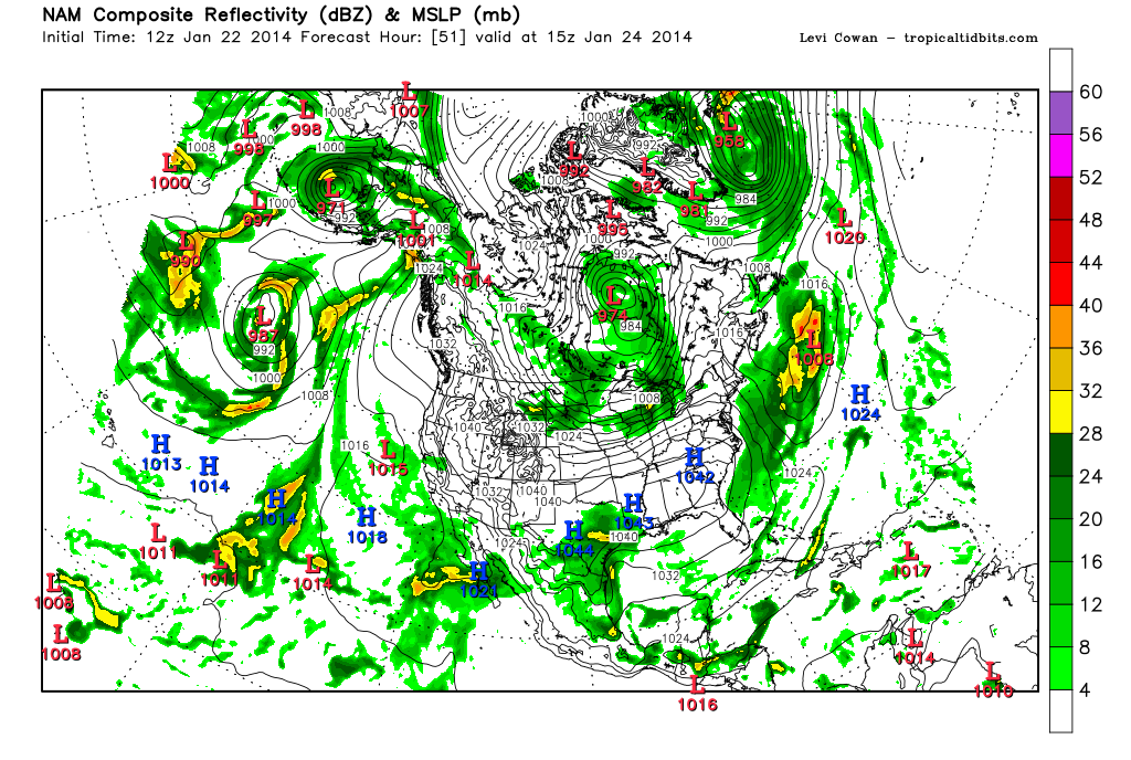
The 12Z NAM is getting into range where that shorter term model can begin to pick up on subtle features such as banding/higher reflectivity solutions and such. The 12Z version of the NAM is suggesting a Coastal trough/low near the Lower Texas Coast, brighter banding features N of the Coastal trough where heavier precipitation may develop and temperatures cold enough to support wintry weather.
Last edited by srainhoutx on Wed Jan 22, 2014 9:51 am, edited 1 time in total.
0 likes
Carla/Alicia/Jerry(In The Eye)/Michelle/Charley/Ivan/Dennis/Katrina/Rita/Wilma/Ike/Harvey
Member: National Weather Association
Wx Infinity Forums
http://wxinfinity.com/index.php
Facebook.com/WeatherInfinity
Twitter @WeatherInfinity
Member: National Weather Association
Wx Infinity Forums
http://wxinfinity.com/index.php
Facebook.com/WeatherInfinity
Twitter @WeatherInfinity
-
Stormcenter
- S2K Supporter
- Posts: 6689
- Joined: Wed Sep 03, 2003 11:27 am
- Location: Houston, TX
-
northjaxpro

- S2K Supporter
- Posts: 8900
- Joined: Mon Sep 27, 2010 11:21 am
- Location: Jacksonville, FL
I don't like to look too far out ahead in the long range as it is just in most cases as some has stated: LA LA land.
However, there are indications that a blocking pattern may become established near Greenland by the first week of February. If this happens, along with the ridging already established over the EPAC and Western U.S., it is feasible to see a motherload of Siberian air to come southbound into the CONUS.
So, the GFS 372 hr run is way out there, but if a solid blocking pattern continues into first week of February, a 1062 mb Arctic High dropping down is a viable possibility indeed
0 likes
NEVER, EVER SAY NEVER in the tropics and weather in general, and most importantly, with life itself!!
________________________________________________________________________________________
Fay 2008 Beryl 2012 Debby 2012 Colin 2016 Hermine 2016 Julia 2016 Matthew 2016 Irma 2017 Dorian 2019
________________________________________________________________________________________
Fay 2008 Beryl 2012 Debby 2012 Colin 2016 Hermine 2016 Julia 2016 Matthew 2016 Irma 2017 Dorian 2019
Re: Texas Winter 2013-2014
The Heat Miser shudders briefly at the thought of such high pressure coming down from Canada. Then quickly realizes it is the GFS @ 372 hrs and wipes the sweat from his brow in relief. "Plenty of time for this to change", he thinks to himself.
0 likes
-
Red Raider fan

- Tropical Depression

- Posts: 72
- Joined: Fri Dec 13, 2013 11:31 am
- Location: Schertz Tx.

Who is online
Users browsing this forum: No registered users and 39 guests