Texas Winter 2013-2014

Winter Weather Discussion

Moderator: S2k Moderators

Forum rules

The posts in this forum are NOT official forecast and should not be used as such. They are just the opinion of the poster and may or may not be backed by sound meteorological data. They are NOT endorsed by any professional institution or STORM2K.

Help Support Storm2K
Message
Author
User avatar
TeamPlayersBlue
Category 5
Category 5
Posts: 3462
Joined: Tue Feb 02, 2010 1:44 am
Location: Denver/Applewood, CO

Re: Re:

#4441 Postby TeamPlayersBlue » Wed Jan 22, 2014 6:29 pm

Rgv20 wrote:
davidiowx wrote:
Rgv20 wrote:12zECMWF Ensemble Means shows almost an inch of Snow for Austin/Mabry...Hope you get something Porta!


What does it show for the Houston area?


Checking the various station plots from the ECMWF Ensemble Means it shows 0.8 to almost 1''.


This could be sleet as well though huh?
0 likes   
Personal Forecast Disclaimer:
The posts in this forum are NOT official forecast and should not be used as such. They are just the opinion of the poster and may or may not be backed by sound meteorological data. They are NOT endorsed by any professional institution or storm2k.org. For official information, please refer to the NHC and NWS products.

User avatar
Portastorm
Storm2k Moderator
Storm2k Moderator
Posts: 9914
Age: 63
Joined: Fri Jul 11, 2003 9:16 am
Location: Round Rock, TX
Contact:

Re: Texas Winter 2013-2014

#4442 Postby Portastorm » Wed Jan 22, 2014 6:33 pm

ronyan wrote:Looking to next week, the GFS shows a 1048+ mb high entering Montana/South Dakota @ hr 132. The 850mb 0C line is off the coast by hr 156 but it looks like a dry cold on the 18z GFS. Still plenty of time for things to change on that. :wink:


Seen the 12z Euro or CMC? That might cheer you up a bit. Hint: it is cold but NOT dry. :wink:
0 likes   
Any forecasts under my name are to be taken with a grain of salt. Get your best forecasts from the National Weather Service and National Hurricane Center.

User avatar
dhweather
S2K Supporter
S2K Supporter
Posts: 6199
Joined: Sat Aug 14, 2004 9:29 pm
Location: Heath, TX
Contact:

Re: Texas Winter 2013-2014

#4443 Postby dhweather » Wed Jan 22, 2014 6:34 pm

18Z meteograms for DFW - cold and dry

Image

Image


Hmmm, I just noticed a bug in the new and improved meteogram spreadsheet for 192+ - it's not putting the dates in correctly. We will get that fixed.
0 likes   
The above post and any post by dhweather is NOT an official forecast and should not be used as such. It is just the opinion of the poster and may or may not be backed by sound meteorological data. It is NOT endorsed by any professional institution including storm2k.org. For official information, please refer to NWS products.

User avatar
TheProfessor
Professional-Met
Professional-Met
Posts: 3506
Age: 29
Joined: Tue Dec 03, 2013 10:56 am
Location: Wichita, Kansas

#4444 Postby TheProfessor » Wed Jan 22, 2014 6:41 pm

Friday looks like a terrible day for me! I loathe cold and sunny weather! :x
0 likes   
An alumnus of The Ohio State University.

Your local National Weather Service office is your best source for weather information.

User avatar
TheProfessor
Professional-Met
Professional-Met
Posts: 3506
Age: 29
Joined: Tue Dec 03, 2013 10:56 am
Location: Wichita, Kansas

#4445 Postby TheProfessor » Wed Jan 22, 2014 7:18 pm

I just now looked at the SERF and it has been trending a lot wetter for the DFW metroplex. perhaps this is why flurries are now in are forecast.
0 likes   
An alumnus of The Ohio State University.

Your local National Weather Service office is your best source for weather information.

User avatar
Rgv20
S2K Supporter
S2K Supporter
Posts: 2466
Age: 39
Joined: Wed Jan 05, 2011 5:42 pm
Location: Edinburg/McAllen Tx

#4446 Postby Rgv20 » Wed Jan 22, 2014 7:42 pm

Image
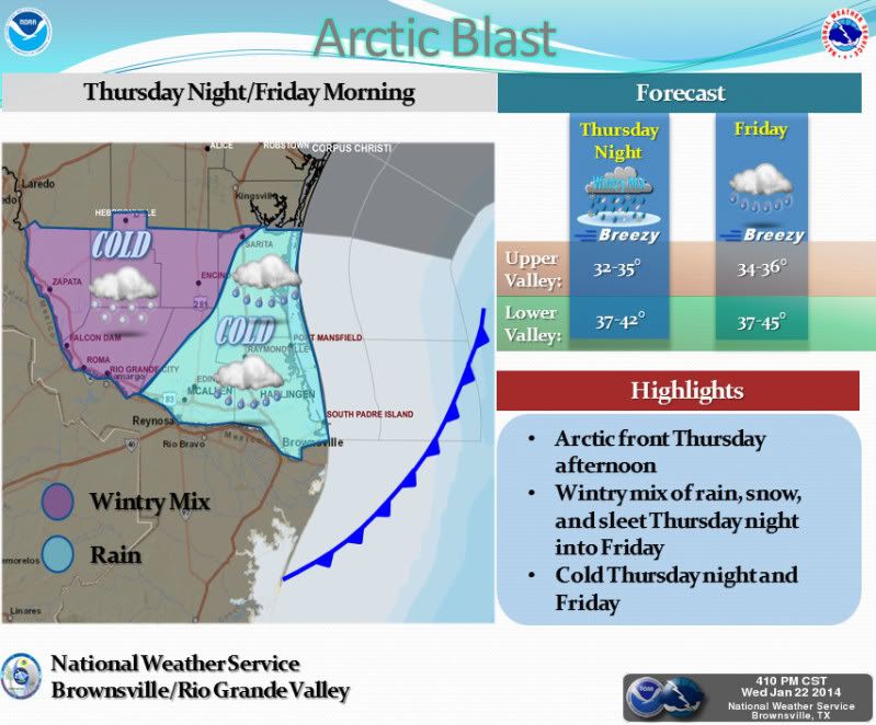
A strong Arctic front will sweep through the Rio Grande Valley and Deep South Texas Thursday afternoon. The front will usher in a big change with cold north winds and quickly dropping temperatures. Widespread precipitation will develop Thursday night and Friday as an upper disturbance approaches then combines with a developing coastal trough. There is a fair chance a wintry mix of rain, snow, and sleet developing over the northern and western Ranch Lands, with the greatest chances mainly west of a Falfurrias to Rio Grande City line. With temperatures remaining above freezing, no significant accumulations are expected. Residents are urged to monitor the latest forecasts and statements from the National Weather Service. -Campbell/Billings-
0 likes   
The following post is NOT an official forecast and should not be used as such. It is just the opinion of the poster and may or may not be backed by sound meteorological data. It is NOT endorsed by any professional institution including storm2k.org For Official Information please refer to the NHC and NWS products.

User avatar
Ntxw
Storm2k Moderator
Storm2k Moderator
Posts: 22897
Joined: Wed Oct 21, 2009 6:34 pm
Location: DFW, Texas

Re: Texas Winter 2013-2014

#4447 Postby Ntxw » Wed Jan 22, 2014 8:11 pm

This is too funny, a few days ago models had no big high after the current one and the long range (which GFS is still on with). And now there's a 1048-1050+ coming early next week lol. I bet it's that warm pool doing it's dirty work. Never seen a year with so many big ones, maybe it will all come tumbling down and an epic one will finish out winter!
0 likes   
The above post and any post by Ntxw is NOT an official forecast and should not be used as such. It is just the opinion of the poster and may or may not be backed by sound meteorological data. It is NOT endorsed by any professional institution including Storm2k. For official information, please refer to NWS products.

  Help support Storm2K!
Help Support Storm2K

User avatar
Ntxw
Storm2k Moderator
Storm2k Moderator
Posts: 22897
Joined: Wed Oct 21, 2009 6:34 pm
Location: DFW, Texas

#4448 Postby Ntxw » Wed Jan 22, 2014 8:37 pm

Here's proof to the -EPO as the king of cold. Western and NW Canada is and has been 20-40F above normal. Yet Texas is about to see a cold wave some 15-20F below normal, and another one early next week similar in nature if not a little colder while Western Canada remains 20F+ from normal.
0 likes   
The above post and any post by Ntxw is NOT an official forecast and should not be used as such. It is just the opinion of the poster and may or may not be backed by sound meteorological data. It is NOT endorsed by any professional institution including Storm2k. For official information, please refer to NWS products.


  Help support Storm2K!

Help Support Storm2K


gpsnowman
S2K Supporter
S2K Supporter
Posts: 3214
Joined: Fri Jan 07, 2011 10:35 am
Location: Grand Prairie Tx

#4449 Postby gpsnowman » Wed Jan 22, 2014 8:53 pm

Hey Ntwx, have precip chances gone up any at all for DFW?
0 likes   

User avatar
gboudx
S2K Supporter
S2K Supporter
Posts: 4080
Joined: Thu Sep 04, 2003 1:39 pm
Location: Rockwall, Tx but from Harvey, La

#4450 Postby gboudx » Wed Jan 22, 2014 9:03 pm

FWIW, Steve McCauley doesn't think DFW will get much of anything, including flurries.
0 likes   

User avatar
Ntxw
Storm2k Moderator
Storm2k Moderator
Posts: 22897
Joined: Wed Oct 21, 2009 6:34 pm
Location: DFW, Texas

Re:

#4451 Postby Ntxw » Wed Jan 22, 2014 9:07 pm

gpsnowman wrote:Hey Ntwx, have precip chances gone up any at all for DFW?


I don't think so. For the most part this is an I-10 and central Texas affair not a Red River valley north TX/Oklahoma ordeal. The high is moving backwards (from the NE) and centered over our region thus no moisture will likely make it. Our game is later next week when the PNA is negative, that's when the big storms will start kicking out and we see the usual set up for the southern plains as whole for a dynamic system.
0 likes   
The above post and any post by Ntxw is NOT an official forecast and should not be used as such. It is just the opinion of the poster and may or may not be backed by sound meteorological data. It is NOT endorsed by any professional institution including Storm2k. For official information, please refer to NWS products.


  Help support Storm2K!

Help Support Storm2K


jerryh421
Tropical Depression
Tropical Depression
Posts: 91
Joined: Wed Feb 02, 2011 1:02 am
Location: Houston, Texas

#4452 Postby jerryh421 » Wed Jan 22, 2014 9:20 pm

When do the new models come out??
0 likes   

User avatar
Ntxw
Storm2k Moderator
Storm2k Moderator
Posts: 22897
Joined: Wed Oct 21, 2009 6:34 pm
Location: DFW, Texas

Re:

#4453 Postby Ntxw » Wed Jan 22, 2014 9:26 pm

jerryh421 wrote:When do the new models come out??


The 0z NAM is out and it has The Austin area receiving most of the snow/sleet, up to 2+ inches. Williamson county looks good with maybe a bit more of snow. SE Texas the 850 line lags the surface freeze line as precip moves out so probably up to an inch mixture of sleet and freezing rain.
0 likes   
The above post and any post by Ntxw is NOT an official forecast and should not be used as such. It is just the opinion of the poster and may or may not be backed by sound meteorological data. It is NOT endorsed by any professional institution including Storm2k. For official information, please refer to NWS products.


  Help support Storm2K!

Help Support Storm2K


Wntrwthrguy
Tropical Storm
Tropical Storm
Posts: 161
Joined: Thu Nov 21, 2013 8:48 pm
Location: North Austin

#4454 Postby Wntrwthrguy » Wed Jan 22, 2014 9:32 pm

:uarrow: Any idea on when the frozen precip will begin in Williamson county around round rock/hutto? I see different hour by hour forecasts predicting different times the sleet/snow is going to start.
0 likes   
Any post should not be taken as a forecast. I am just an amateur living the dream.

stormlover2013

Re: Texas Winter 2013-2014

#4455 Postby stormlover2013 » Wed Jan 22, 2014 9:37 pm

Pretty strong line of moisture early Friday morning in se tx we shall see if it pans out!!
0 likes   

User avatar
Ntxw
Storm2k Moderator
Storm2k Moderator
Posts: 22897
Joined: Wed Oct 21, 2009 6:34 pm
Location: DFW, Texas

Re:

#4456 Postby Ntxw » Wed Jan 22, 2014 9:37 pm

Wntrwthrguy wrote::uarrow: Any idea on when the frozen precip will begin in Williamson county around round rock/hutto? I see different hour by hour forecasts predicting different times the sleet/snow is going to start.


It has the band at it's peak around between 18z and 21z so anytime between noon and 3pm tomorrow. It's highly dependent on banding features so it's not something we can say it will start at x time. Will have to follow radar trends.
0 likes   
The above post and any post by Ntxw is NOT an official forecast and should not be used as such. It is just the opinion of the poster and may or may not be backed by sound meteorological data. It is NOT endorsed by any professional institution including Storm2k. For official information, please refer to NWS products.


  Help support Storm2K!

Help Support Storm2K


User avatar
South Texas Storms
Professional-Met
Professional-Met
Posts: 4245
Joined: Thu Jun 24, 2010 12:28 am
Location: Houston, TX

Re: Texas Winter 2013-2014

#4457 Postby South Texas Storms » Wed Jan 22, 2014 9:44 pm

Here is my forecast precipitation types for this event. This is the first time I've made a map like this. We'll see how I do!

And here's my latest weather article with more of my ideas on this event!
http://www.examiner.com/article/frozen-precipitation-possible-thursday-night-through-friday

Image

Uploaded with ImageShack.us


Personal Forecast Disclaimer:
The posts in this forum are NOT official forecast and should not be used as such. They are just the opinion of the poster and may or may not be backed by sound meteorological data. They are NOT endorsed by any professional institution or storm2k.org. For official information, please refer to NWS products.
0 likes   

User avatar
srainhoutx
S2K Supporter
S2K Supporter
Posts: 6919
Age: 68
Joined: Sun Jan 14, 2007 11:34 am
Location: Haywood County, NC
Contact:

Re: Texas Winter 2013-2014

#4458 Postby srainhoutx » Wed Jan 22, 2014 9:49 pm

The 21Z SREF ensemble mean continues to advertise a prolonged light freezing rain/sleet event that finally begins to wind down Friday night/early Saturday morning. The 00Z NAM suggests a tab bit more moisture that comes to an end in SE Texas Friday afternoon/evening. Both of these shorter range meso models are suggesting a Coastal trough/low near Brownsville/Corpus Christi. Also of note, CLL will do a special sounding (ballon launch) 00Z tomorrow and possibly one at 06Z to assist NWS Houston/Galveston.
0 likes   
Carla/Alicia/Jerry(In The Eye)/Michelle/Charley/Ivan/Dennis/Katrina/Rita/Wilma/Ike/Harvey

Member: National Weather Association
Wx Infinity Forums
http://wxinfinity.com/index.php

Facebook.com/WeatherInfinity
Twitter @WeatherInfinity

User avatar
Ntxw
Storm2k Moderator
Storm2k Moderator
Posts: 22897
Joined: Wed Oct 21, 2009 6:34 pm
Location: DFW, Texas

Re: Texas Winter 2013-2014

#4459 Postby Ntxw » Wed Jan 22, 2014 9:53 pm

stormlover2013 wrote:Pretty strong line of moisture early Friday morning in se tx we shall see if it pans out!!


Houston will be an interesting case. Temperature profiles here are tricky as the cold is not as deep as Austin (roads there should be a mess since they will fall below the magical 27-29 threshold that usually sticks to main roads). Stuff will fall and likely bridges and overpasses in Houston will become a wrecking ball (30-32 range) assuming the model is correct. Of course in this part of the world just the idea of something falling is plenty enough for jams :wink:. I wonder if the schools will close as a precaution?
0 likes   
The above post and any post by Ntxw is NOT an official forecast and should not be used as such. It is just the opinion of the poster and may or may not be backed by sound meteorological data. It is NOT endorsed by any professional institution including Storm2k. For official information, please refer to NWS products.


  Help support Storm2K!

Help Support Storm2K


User avatar
Portastorm
Storm2k Moderator
Storm2k Moderator
Posts: 9914
Age: 63
Joined: Fri Jul 11, 2003 9:16 am
Location: Round Rock, TX
Contact:

Re: Re:

#4460 Postby Portastorm » Wed Jan 22, 2014 9:55 pm

Ntxw wrote:
Wntrwthrguy wrote::uarrow: Any idea on when the frozen precip will begin in Williamson county around round rock/hutto? I see different hour by hour forecasts predicting different times the sleet/snow is going to start.


It has the band at it's peak around between 18z and 21z so anytime between noon and 3pm tomorrow. It's highly dependent on banding features so it's not something we can say it will start at x time. Will have to follow radar trends.


If that's the case then I'm afraid much of that precip will be liquid and falling onto ground surfaces above freezing. Unless the models have the temps way off, the general AUS metro area won't cool to 32 or below until 5-6 p.m.
0 likes   
Any forecasts under my name are to be taken with a grain of salt. Get your best forecasts from the National Weather Service and National Hurricane Center.


Return to “Winter Weather”

Who is online

Users browsing this forum: Google Adsense [Bot] and 94 guests