Texas Winter 2013-2014

Winter Weather Discussion

Moderator: S2k Moderators

Forum rules

The posts in this forum are NOT official forecast and should not be used as such. They are just the opinion of the poster and may or may not be backed by sound meteorological data. They are NOT endorsed by any professional institution or STORM2K.

Help Support Storm2K
Message
Author
User avatar
Ntxw
Storm2k Moderator
Storm2k Moderator
Posts: 22896
Joined: Wed Oct 21, 2009 6:34 pm
Location: DFW, Texas

Re: Texas Winter 2013-2014

#4841 Postby Ntxw » Thu Jan 23, 2014 8:34 pm

South Texas Storms wrote:Wow I hope you're right! So you think the convective bands will hit after midnight and give us a few inches then?


Lets hope so, that's the model consensus anyway.
0 likes   
The above post and any post by Ntxw is NOT an official forecast and should not be used as such. It is just the opinion of the poster and may or may not be backed by sound meteorological data. It is NOT endorsed by any professional institution including Storm2k. For official information, please refer to NWS products.

  Help support Storm2K!
Help Support Storm2K

User avatar
Portastorm
Storm2k Moderator
Storm2k Moderator
Posts: 9914
Age: 63
Joined: Fri Jul 11, 2003 9:16 am
Location: Round Rock, TX
Contact:

Re: Texas Winter 2013-2014

#4842 Postby Portastorm » Thu Jan 23, 2014 8:37 pm

I sure don't understand seeing the news that some of these ISDs in the general Austin area are notifying about a two-hour delay tomorrow. It's not going to be much better at 10 am than it is at 7 or 8 am tomorrow. We won't get above freezing by then. If they feel compelled to "make the call" the night before then they should plan for a longer time frame.
0 likes   
Any forecasts under my name are to be taken with a grain of salt. Get your best forecasts from the National Weather Service and National Hurricane Center.

User avatar
South Texas Storms
Professional-Met
Professional-Met
Posts: 4245
Joined: Thu Jun 24, 2010 12:28 am
Location: Houston, TX

Re: Texas Winter 2013-2014

#4843 Postby South Texas Storms » Thu Jan 23, 2014 8:40 pm

Ntxw wrote:
South Texas Storms wrote:Wow I hope you're right! So you think the convective bands will hit after midnight and give us a few inches then?


Lets hope so, that's the model consensus anyway.


Thanks Ntxw. I'll keep yall updated!
0 likes   

User avatar
gboudx
S2K Supporter
S2K Supporter
Posts: 4080
Joined: Thu Sep 04, 2003 1:39 pm
Location: Rockwall, Tx but from Harvey, La

#4844 Postby gboudx » Thu Jan 23, 2014 8:40 pm

Here's an update from jeff. My apologies if already posted. You folks are tearing through to new pages pretty quickly. :D

Things starting to go downhill.

Freezing line has breached our northern counties with Caldwell now at 32 and CLL at 35. TXDOT is showing ice formation on roadways just outside our region mainly along and north of HWY 190 from Hearne to Round Rock. Appears another surge of cold/dry air is moving into the region and this should push much of the area to freezing in the midnight to 300am period.

A review of roadway versus air temperatures shows roadway bridges running about 3 degrees higher than air temperatures indicating critical air temperature for ice formation on bridges will be in the 29-30 degree range. This is currently fairly uniform across the entire region…but the difference is starting to close NW of Harris County where the air has been colder longer cooling those bridges.

See now reason to change any accumulation and P-type forms at this time.

Travel will be extremely hazardous after midnight tonight for most areas and all areas by 300am. Avoid travel unless it is an emergency.

Not sure if/when we will rise above freezing on Friday. Some of the models are attempting to hang on to sub-32F temperatures until the early to mid afternoon hours….much will depend on how quickly the precipitation ends. Still expect roadways to be a big problem for a good part of Friday.

Next update will be between 10-11pm.
0 likes   

User avatar
Portastorm
Storm2k Moderator
Storm2k Moderator
Posts: 9914
Age: 63
Joined: Fri Jul 11, 2003 9:16 am
Location: Round Rock, TX
Contact:

Re: Texas Winter 2013-2014

#4845 Postby Portastorm » Thu Jan 23, 2014 8:40 pm

Latest water vapor feed shows a solid and steady amount of Pacific moisture streaming into the state.

http://www.ssec.wisc.edu/data/geo/index.php?satellite=east&channel=wv&coverage=conus&file=gif&imgoranim=8&anim_method=flash
0 likes   
Any forecasts under my name are to be taken with a grain of salt. Get your best forecasts from the National Weather Service and National Hurricane Center.

Wntrwthrguy
Tropical Storm
Tropical Storm
Posts: 161
Joined: Thu Nov 21, 2013 8:48 pm
Location: North Austin

Re: Texas Winter 2013-2014

#4846 Postby Wntrwthrguy » Thu Jan 23, 2014 8:41 pm

Latest HRRR (RUC) -- 22z -- still looks good for you, buddy. Still showing 1-2 inches. Keep the faith![/quote]

How does it look for the Austin area? Is the best still to come?
0 likes   
Any post should not be taken as a forecast. I am just an amateur living the dream.

User avatar
Portastorm
Storm2k Moderator
Storm2k Moderator
Posts: 9914
Age: 63
Joined: Fri Jul 11, 2003 9:16 am
Location: Round Rock, TX
Contact:

Re: Texas Winter 2013-2014

#4847 Postby Portastorm » Thu Jan 23, 2014 8:42 pm

Wntrwthrguy wrote:How does it look for the Austin area? Is the best still to come?


Off and on again precip from now until 4-5 am. Still looking like accumulations of a wintry slop between 1/2 and 1 inch.

Meanwhile, APD is reporting 25 accidents in the last 30 minutes alone. Hopefully persons will get off the roads soon.
0 likes   
Any forecasts under my name are to be taken with a grain of salt. Get your best forecasts from the National Weather Service and National Hurricane Center.

User avatar
cheezyWXguy
Category 5
Category 5
Posts: 6238
Joined: Mon Feb 13, 2006 12:29 am
Location: Dallas, TX

Re: Texas Winter 2013-2014

#4848 Postby cheezyWXguy » Thu Jan 23, 2014 8:43 pm

South Texas Storms wrote:
Ntxw wrote:
South Texas Storms wrote:What time do you think the changeover may occur? You think we could see a few good hours of moderate snow/sleet around midnight?


Probably within the next 3 hours to snow, well before the convective stuff hits. I think you guys in CLL will end up with 1-3", while some areas just to your east may end up 2-4.


Wow I hope you're right! So you think the convective bands will hit after midnight and give us a few inches then?

well I dont know if you've noticed, South Texas, but we have in fact been switching between rain and sleet here in College Station. But wow, 1-3" was a little above what I was expecting. If that's the case I dont think I'll be going to class tomorrow.
0 likes   

User avatar
JDawg512
Category 5
Category 5
Posts: 1081
Age: 45
Joined: Mon Aug 26, 2013 8:56 pm
Location: Austin
Contact:

Re: Texas Winter 2013-2014

#4849 Postby JDawg512 » Thu Jan 23, 2014 8:43 pm

I agree Porta. I'm a bit peeved at ACC. Our instructor said that if things got bad they would release classes early. Well 10 min before class normally ends. We walk outside and it's sleeting. I had to have been sleeting for awhile cause my car was coated. Took well over an hour to get home. They underestimated this or at any rate they chose to stay on the conservative side of forecasting.
0 likes   
Resident Rain Miser

I am a weather hobbyist living 3.5 miles south of Downtown Austin and in no way or fashion should anything I say concerning forecasts be taken seriously. Please check your local NWS for accurate weather forecasting and conditions.

User avatar
somethingfunny
ChatStaff
ChatStaff
Posts: 3926
Age: 37
Joined: Thu May 31, 2007 10:30 pm
Location: McKinney, Texas

Re: Texas Winter 2013-2014

#4850 Postby somethingfunny » Thu Jan 23, 2014 8:44 pm

cheezyWXguy wrote:well I dont know if you've noticed, South Texas, but we have in fact been switching between rain and sleet here in College Station. But wow, 1-3" was a little above what I was expecting. If that's the case I dont think I'll be going to class tomorrow.


You may want to check in on that rain, find a cold elevated surface like a chain link fence - it might actually be freezing rain rather than plain rain if it's mixing with sleet.
0 likes   
I am not a meteorologist, and any posts made by me are not official forecasts or to be interpreted as being intelligent. These posts are just my opinions and are probably silly opinions.

User avatar
Ntxw
Storm2k Moderator
Storm2k Moderator
Posts: 22896
Joined: Wed Oct 21, 2009 6:34 pm
Location: DFW, Texas

#4851 Postby Ntxw » Thu Jan 23, 2014 8:52 pm

Further north, if we haven't noticed MOS guidance has DFW getting down to 15-16F tonight. That would be impressive, I'm not sure I believe it right now because winds and clouds are in place but dew points are definitely there. What model predicted that?
0 likes   
The above post and any post by Ntxw is NOT an official forecast and should not be used as such. It is just the opinion of the poster and may or may not be backed by sound meteorological data. It is NOT endorsed by any professional institution including Storm2k. For official information, please refer to NWS products.


  Help support Storm2K!

Help Support Storm2K


downsouthman1
Category 2
Category 2
Posts: 663
Age: 45
Joined: Fri Jan 07, 2011 8:14 pm
Location: Rowlett, TX

#4852 Postby downsouthman1 » Thu Jan 23, 2014 8:53 pm

Check this out everyone. SJT radar still shows a backbuilding convective band developing out west. 2 actually. It kinda looks like they're trying to merge into one. http://www.wunderground.com/radar/radbl ... oth=0&MR=1

Edit: Under this band, even with a 12 degree Dewpoint, it's snowing in Brady. Airport confirms that it's reaching the ground. How's that for upper level support?
0 likes   
Not a professional MET! My posts are merely speculation.

User avatar
South Texas Storms
Professional-Met
Professional-Met
Posts: 4245
Joined: Thu Jun 24, 2010 12:28 am
Location: Houston, TX

Re: Texas Winter 2013-2014

#4853 Postby South Texas Storms » Thu Jan 23, 2014 8:55 pm

I still haven't seen any sleet mixing with the rain here cheezy. I'm anxiously awaiting it though.
0 likes   

User avatar
Rgv20
S2K Supporter
S2K Supporter
Posts: 2466
Age: 39
Joined: Wed Jan 05, 2011 5:42 pm
Location: Edinburg/McAllen Tx

#4854 Postby Rgv20 » Thu Jan 23, 2014 8:58 pm

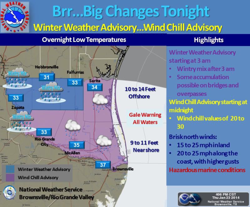
Its already down to 44 with drizzle and really gusty north winds..

Image
A strong Arctic front will push its way across the Rio Grande Valley and Deep South Texas this evening. This front will usher in much colder temperatures and brisk northerly winds of 15 to 25 mph that will make temperatures feel much colder. A Wind Chill Advisory is in effect from midnight tonight through Friday for all of the Rio Grande Valley and Deep South Texas. Dangerous wind chills are expected after midnight, with wind chill values of 20 to 30. Widespread precipitation will develop tonight, in the form of rain before 3 am. After 3 am, there is a fair chance of a wintry mix of rain and sleet developing over the northern and western ranch lands, with the greatest chances mainly west of a Falfurrias to Rio Grande City line. A Winter Weather Advisory has been issued Zapata, Jim Hogg, and Brooks counties from 3 am to noon Friday; some accumulation is possible on bridges and overpasses in the advisory area. If you are going to be outside dress in layers and wear a hat. Cover or bring inside cold sensitive vegetation and don't forget your outside pets!
0 likes   
The following post is NOT an official forecast and should not be used as such. It is just the opinion of the poster and may or may not be backed by sound meteorological data. It is NOT endorsed by any professional institution including storm2k.org For Official Information please refer to the NHC and NWS products.

weatherdude1108
Category 5
Category 5
Posts: 4228
Joined: Tue Dec 13, 2011 1:04 pm
Location: Northwest Austin/Cedar Park, TX

#4855 Postby weatherdude1108 » Thu Jan 23, 2014 8:58 pm

This was in my backyard around 6pm tonight when it was sleeting.
Image
0 likes   

User avatar
Annie Oakley
Category 5
Category 5
Posts: 1103
Joined: Tue Jul 31, 2007 12:54 pm
Location: Texas

#4856 Postby Annie Oakley » Thu Jan 23, 2014 9:05 pm

The Austin NWS site shows 32 degrees and 'unknown precip'......what does that mean? The unknown precip part, that is....
0 likes   

User avatar
cheezyWXguy
Category 5
Category 5
Posts: 6238
Joined: Mon Feb 13, 2006 12:29 am
Location: Dallas, TX

Re: Texas Winter 2013-2014

#4857 Postby cheezyWXguy » Thu Jan 23, 2014 9:07 pm

South Texas Storms wrote:I still haven't seen any sleet mixing with the rain here cheezy. I'm anxiously awaiting it though.

Really? It changed completely over for a few minutes, theres a glaze on the railings and steps at my apartment right now. Its calmed down a bit for now though
0 likes   

User avatar
South Texas Storms
Professional-Met
Professional-Met
Posts: 4245
Joined: Thu Jun 24, 2010 12:28 am
Location: Houston, TX

Re: Texas Winter 2013-2014

#4858 Postby South Texas Storms » Thu Jan 23, 2014 9:09 pm

cheezyWXguy wrote:
South Texas Storms wrote:I still haven't seen any sleet mixing with the rain here cheezy. I'm anxiously awaiting it though.

Really? It changed completely over for a few minutes, theres a glaze on the railings and steps at my apartment right now. Its calmed down a bit for now though


Where do you live? I live right across from the mall here.
0 likes   

User avatar
cheezyWXguy
Category 5
Category 5
Posts: 6238
Joined: Mon Feb 13, 2006 12:29 am
Location: Dallas, TX

Re: Texas Winter 2013-2014

#4859 Postby cheezyWXguy » Thu Jan 23, 2014 9:15 pm

South Texas Storms wrote:
cheezyWXguy wrote:
South Texas Storms wrote:I still haven't seen any sleet mixing with the rain here cheezy. I'm anxiously awaiting it though.

Really? It changed completely over for a few minutes, theres a glaze on the railings and steps at my apartment right now. Its calmed down a bit for now though


Where do you live? I live right across from the mall here.

Im near where Holleman and Harvey Mitchell intersect. Im pretty surprised it can be so different across just a few miles. There hasn't been much for me yet though so you're not really missing out.
0 likes   

User avatar
Texas Snowman
Storm2k Moderator
Storm2k Moderator
Posts: 6181
Joined: Fri Jan 25, 2008 11:29 am
Location: Denison, Texas

Re:

#4860 Postby Texas Snowman » Thu Jan 23, 2014 9:16 pm

Ntxw wrote:Further north, if we haven't noticed MOS guidance has DFW getting down to 15-16F tonight. That would be impressive, I'm not sure I believe it right now because winds and clouds are in place but dew points are definitely there. What model predicted that?


Certainly not the Wxman57 model. I'm pretty sure it said no more real cold or winter weather in Texas during the month of January!! :D
0 likes   
The above post and any post by Texas Snowman is NOT an official forecast and should not be used as such. It is just the opinion of the poster and may or may not be backed by sound meteorological data. It is NOT endorsed by any professional institution including storm2k.org. For official information, please refer to NWS products.


Return to “Winter Weather”

Who is online

Users browsing this forum: No registered users and 61 guests