Texas Winter 2013-2014
Moderator: S2k Moderators
Forum rules
 The posts in this forum are NOT official forecast and should not be used as such. They are just the opinion of the poster and may or may not be backed by sound meteorological data. They are NOT endorsed by any professional institution or STORM2K.

The posts in this forum are NOT official forecast and should not be used as such. They are just the opinion of the poster and may or may not be backed by sound meteorological data. They are NOT endorsed by any professional institution or STORM2K.
-
HouTXmetro

- Category 5

- Posts: 3949
- Joined: Sun Jun 13, 2004 6:00 pm
- Location: District of Columbia, USA
Re: Texas Winter 2013-2014
I was hoping we could get a bigger badder storm out of this but I'll take what I can get!!! I mean we already reached our Winter Weather quota for the decade a few days ago. So all this is a bonus.
0 likes
[Disclaimer: My Amateur Opinion, please defer to your local authorities or the NHC for Guidance.]
-
Portastorm

- Storm2k Moderator

- Posts: 9955
- Age: 63
- Joined: Fri Jul 11, 2003 9:16 am
- Location: Round Rock, TX
- Contact:

Re:
BigB0882 wrote:The NAM was overblown for Austin but it was way underdone for points east. So anything is possible!
A lot will depend if a coastal trough can form and a good one since the northern stream and southern stream are disconnected. The NAM has slowly been trending away from the connection since it's run a few nights ago. I'd say with good certainty some places along the gulf coast and or deep south Texas could see flurries on the backside of the front since the air mass is so deep but for more than that will require a good coastal low. Cold dry air will be fighting moisture return even further south than last week so it will take a good 5h shortwave to drag moisture against the surging air mass.
0 likes
The above post and any post by Ntxw is NOT an official forecast and should not be used as such. It is just the opinion of the poster and may or may not be backed by sound meteorological data. It is NOT endorsed by any professional institution including Storm2k. For official information, please refer to NWS products.
Help support Storm2K!
-
HouTXmetro
- Category 5
- Posts: 3949
- Joined: Sun Jun 13, 2004 6:00 pm
- Location: District of Columbia, USA
Re: Texas Winter 2013-2014
https://twitter.com/TropicalTidbits/sta ... 72/photo/1
I'm going to take a guess, if that happens chances of Winter event along Gulf coast shoots up?
Per Levi Cowan: 0z models suddenly deciding to bring upper low west of California eastward into the GOM seems to be the wildcard.
I'm going to take a guess, if that happens chances of Winter event along Gulf coast shoots up?
0 likes
[Disclaimer: My Amateur Opinion, please defer to your local authorities or the NHC for Guidance.]
-
Rgv20

- S2K Supporter

- Posts: 2466
- Age: 39
- Joined: Wed Jan 05, 2011 5:42 pm
- Location: Edinburg/McAllen Tx
0zCMC has winter fun for South/Central Texas on Tuesday and Wednesday! Starting Wednesday morning it has sleet/snow for my area, going to be interesting what the ECMWF shows in about 30 minutes or so 
0zCMC Tuesday Evening.
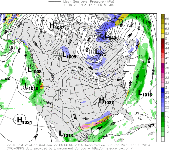
0zCMC Wednesday Morning.
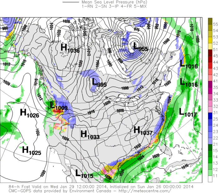
0zCMC Tuesday Evening.

0zCMC Wednesday Morning.

0 likes
The following post is NOT an official forecast and should not be used as such. It is just the opinion of the poster and may or may not be backed by sound meteorological data. It is NOT endorsed by any professional institution including storm2k.org For Official Information please refer to the NHC and NWS products.
-
CYCLONE MIKE
- Category 5
- Posts: 2183
- Joined: Tue Aug 31, 2004 6:04 pm
- Location: Gonzales, LA
Re: Texas Winter 2013-2014
Very interesting indeed. Now that it seems the 0zgfs is coming into agreement as well we could very well be on our way to looking at another winter storm for the deep south in less than a week. Hopefully don't wake up tomorrow and models have gone poof. 
0 likes
-
Rgv20
- S2K Supporter
- Posts: 2466
- Age: 39
- Joined: Wed Jan 05, 2011 5:42 pm
- Location: Edinburg/McAllen Tx
0zECMWF has snow 0.5'' to 1.5''+ inches from around Austin, College Station, Huntsville , Houston and all of Southern LA with New Orleans receiving 2+ inches!  Does not show anything for Southern Texas tho :/
Looks like the Euro wants to move the 500mb low very slowly(thru Thursday Evening still has it in old central Mexico, while the NAM, GFS, and CMC eject it over Southern Texas by Wednesday.
Looks like the Euro wants to move the 500mb low very slowly(thru Thursday Evening still has it in old central Mexico, while the NAM, GFS, and CMC eject it over Southern Texas by Wednesday.
0 likes
The following post is NOT an official forecast and should not be used as such. It is just the opinion of the poster and may or may not be backed by sound meteorological data. It is NOT endorsed by any professional institution including storm2k.org For Official Information please refer to the NHC and NWS products.
-
HouTXmetro
- Category 5
- Posts: 3949
- Joined: Sun Jun 13, 2004 6:00 pm
- Location: District of Columbia, USA
Re:
Rgv20 wrote:0zECMWF has snow 0.5'' to 1.5''+ inches from around Austin, College Station, Huntsville , Houston and all of Southern LA with New Orleans receiving 2+ inches!
Looks like the Euro wants to move the 500mb low very slowly(thru Thursday Evening still has it in old central Mexico, while the NAM, GFS, and CMC eject it over Southern Texas by Wednesday.
So if the Euro moves it slower do we miss out on the Winter fun in Texas?
0 likes
[Disclaimer: My Amateur Opinion, please defer to your local authorities or the NHC for Guidance.]
-
Rgv20
- S2K Supporter
- Posts: 2466
- Age: 39
- Joined: Wed Jan 05, 2011 5:42 pm
- Location: Edinburg/McAllen Tx
Re: Texas Winter 2013-2014
stormlover2013 wrote:Anything for the Beaumont area?
Half an inch to 1 inch
HouTXmetro wrote:Rgv20 wrote:0zECMWF has snow 0.5'' to 1.5''+ inches from around Austin, College Station, Huntsville , Houston and all of Southern LA with New Orleans receiving 2+ inches!
Looks like the Euro wants to move the 500mb low very slowly(thru Thursday Evening still has it in old central Mexico, while the NAM, GFS, and CMC eject it over Southern Texas by Wednesday.
So if the Euro moves it slower do we miss out on the Winter fun in Texas?
The Southern Half of Texas will...Right now tho the ECMWF and UKMET are on the slower side and GFS, CMC, NAM, and even the NAVGEM are faster.
0 likes
The following post is NOT an official forecast and should not be used as such. It is just the opinion of the poster and may or may not be backed by sound meteorological data. It is NOT endorsed by any professional institution including storm2k.org For Official Information please refer to the NHC and NWS products.
-
HouTXmetro
- Category 5
- Posts: 3949
- Joined: Sun Jun 13, 2004 6:00 pm
- Location: District of Columbia, USA
Re: Texas Winter 2013-2014
Rgv20 wrote:stormlover2013 wrote:Anything for the Beaumont area?
Half an inch to 1 inchHouTXmetro wrote:Rgv20 wrote:0zECMWF has snow 0.5'' to 1.5''+ inches from around Austin, College Station, Huntsville , Houston and all of Southern LA with New Orleans receiving 2+ inches!
Looks like the Euro wants to move the 500mb low very slowly(thru Thursday Evening still has it in old central Mexico, while the NAM, GFS, and CMC eject it over Southern Texas by Wednesday.
So if the Euro moves it slower do we miss out on the Winter fun in Texas?
The Southern Half of Texas will...Right now tho the ECMWF and UKMET are on the slower side and GFS, CMC, NAM, and even the NAVGEM are faster.
Ok, EURO slower....But if that's the case wouldn't Central/SE Texas areas miss out too? I would think the dry air would be entrenched by then. Just trying to understand.
0 likes
[Disclaimer: My Amateur Opinion, please defer to your local authorities or the NHC for Guidance.]
-
Rgv20
- S2K Supporter
- Posts: 2466
- Age: 39
- Joined: Wed Jan 05, 2011 5:42 pm
- Location: Edinburg/McAllen Tx
0 likes
The following post is NOT an official forecast and should not be used as such. It is just the opinion of the poster and may or may not be backed by sound meteorological data. It is NOT endorsed by any professional institution including storm2k.org For Official Information please refer to the NHC and NWS products.
-
HouTXmetro
- Category 5
- Posts: 3949
- Joined: Sun Jun 13, 2004 6:00 pm
- Location: District of Columbia, USA
Re:
Rgv20 wrote::uarrow: Not according to the Euro, it has 0.20 of precipitation from about Austin eastward toward the Beaumont area for Tuesday during the day. I guess another couple nights of staying up way past my bed time model watching! lol
And I thank you!!!!
0 likes
[Disclaimer: My Amateur Opinion, please defer to your local authorities or the NHC for Guidance.]
-
wxman57

- Moderator-Pro Met

- Posts: 23174
- Age: 68
- Joined: Sat Jun 21, 2003 8:06 pm
- Location: Houston, TX (southwest)
Re: Texas Winter 2013-2014
All 3 global models (Euro, GFS, CMC) predict significant snow Tuesday from the Texas coast through the FL Panhandle. NAM does, too. Generally 1-3". That's the only good use for cold. It's rare to see such good agreement on a snow event.
0 likes
-
CYCLONE MIKE
- Category 5
- Posts: 2183
- Joined: Tue Aug 31, 2004 6:04 pm
- Location: Gonzales, LA
Re: Texas Winter 2013-2014
Wxman,
our nws office is only going with .10 in of ice accumulation, lesser qpf (euro/ukmet), right now due the hpc graphics and shortwave not being as strong as some other models are showing. Is the euro that much drier?
our nws office is only going with .10 in of ice accumulation, lesser qpf (euro/ukmet), right now due the hpc graphics and shortwave not being as strong as some other models are showing. Is the euro that much drier?
0 likes
-
Wntrwthrguy
- Tropical Storm

- Posts: 161
- Joined: Thu Nov 21, 2013 8:48 pm
- Location: North Austin
Re: Texas Winter 2013-2014
wxman57 wrote:All 3 global models (Euro, GFS, CMC) predict significant snow Tuesday from the Texas coast through the FL Panhandle. NAM does, too. Generally 1-3". That's the only good use for cold. It's rare to see such good agreement on a snow event.
Anything for the Austin area or is this storm predicted to be south and east?
0 likes
Any post should not be taken as a forecast. I am just an amateur living the dream.
-
Tireman4

- S2K Supporter
- Posts: 5903
- Age: 60
- Joined: Fri Jun 30, 2006 1:08 pm
- Location: Humble, Texas
- Contact:
Re: Texas Winter 2013-2014
'wxman57 wrote:All 3 global models (Euro, GFS, CMC) predict significant snow Tuesday from the Texas coast through the FL Panhandle. NAM does, too. Generally 1-3". That's the only good use for cold. It's rare to see such good agreement on a snow event.
Umm, are you sure you to do this? You realize that you are abandoning all hope of your thermostat working? If this happens, you have to go chasing with Porta in his snow chase car, Champ the Charger.
0 likes
-
srainhoutx

- S2K Supporter
- Posts: 6919
- Age: 68
- Joined: Sun Jan 14, 2007 11:34 am
- Location: Haywood County, NC
- Contact:
Re: Texas Winter 2013-2014
Morning Update from Jeff:
Increasing potential for additional widespread winter precipitation Tuesday and Wednesday.
Appears winter precipitation will start during the mid to late morning hours on Tuesday
Another very strong arctic cold front will blast down the plains today and off the TX coast Monday. Temperatures will fall quickly behind this boundary to freezing by Tuesday morning. Upstream analysis of both surface and temperatures aloft suggest this air mass is about as cold as the air mass the first week of January which brought record cold to many locations across the US. An upper level piece of energy will develop into an upper level low over Baja early in the week and it now appears this system will not cut-off and stall out but instead move across the area in the cold air. Forecast models have really trended wetter overnight with liquid amounts pushing well into our local warning criteria for both ice and snow.
P-type:
Incoming air mass is colder than the last air mass both at the surface and aloft which will likely support a range of P-types across the area. Temperatures will be around 30-33 Tuesday morning and look to fall into the mid 20’s during the day on Tuesday with freezing conditions at all locations by late morning. Expect precipitation to break out from SW to NE during the day with various P-types. Still some uncertainty on the exact thermal profiles:
North of a line from Brenham to The Woodlands to Liberty: sleet changing to snow
North of a line from Columbus to Galveston (including metro Houston): freezing rain and sleet changing to sleet and snow
Coast northward: freezing rain changing to freezing rain and sleet
Thermal profiles show only a modest warm layer in the mid layers and it is possible that effective evaporational cooling of falling precipitation could result in a quicker change to more sleet and snow across a greater part of the area. Much of this depends on just how much warm advection there is in the mid levels.
Accumulations:
Freezing rain and sleet at 26-28 is completely different than at 30-31. Colder temperatures support much more efficient ice formation and almost all liquid freezes producing much more significant glaze. Still some disagreement on the actual liquid amounts, but some of the models are showing between .15 and .40 liquid QPF which could be up to 3.0 inches of snow or around .25 of an inch of ice. A couple models show almost no precipitation across the area as they track the Baja feature further south limiting the precipitation to the coastal bend southward.
Changing P-types will also play havoc with accumulations with more snow resulting in greater accumulations and more freezing rain less. Mix them all together or change the phase over different periods will produce varying amounts.
Still have to keep an eye on the dry air to the north which could cut down on accumulations, but this is looking less of an issue since yesterday.
If the thermal profiles hang on to freezing rain longer across our central and coastal areas…icing is going to be fairly significant possibly pushing over .25 of an inch especially with temperatures forecast to be in the mid to upper 20’s. A quick change to sleet and snow would lower the ice accumulation but increase the snow accumulation…possibly a couple of inches.
Impacts:
Still 48 hours out from any onset of adverse conditions and time for things to change…and they will. Just look how much things have changed since Friday evening. Potential is there for some fairly significant impacts to travel and possibly power.
Confidence has increased over yesterday that precipitation will fall with freezing temperatures, but the amounts and type continue to vary and as with most winter weather events in this area…the confidence is usually not great until the event is nearly ongoing.
A winter storm watch will likely be required either this afternoon or early Monday
Will update again this afternoon after all 12Z (600am) model guidance is in.
0 likes
Carla/Alicia/Jerry(In The Eye)/Michelle/Charley/Ivan/Dennis/Katrina/Rita/Wilma/Ike/Harvey
Member: National Weather Association
Wx Infinity Forums
http://wxinfinity.com/index.php
Facebook.com/WeatherInfinity
Twitter @WeatherInfinity
Member: National Weather Association
Wx Infinity Forums
http://wxinfinity.com/index.php
Facebook.com/WeatherInfinity
Twitter @WeatherInfinity
Who is online
Users browsing this forum: No registered users and 72 guests