Texas Winter 2013-2014

Winter Weather Discussion

Moderator: S2k Moderators

Forum rules

The posts in this forum are NOT official forecast and should not be used as such. They are just the opinion of the poster and may or may not be backed by sound meteorological data. They are NOT endorsed by any professional institution or STORM2K.

Help Support Storm2K
Message
Author
User avatar
Tireman4
S2K Supporter
S2K Supporter
Posts: 5858
Age: 60
Joined: Fri Jun 30, 2006 1:08 pm
Location: Humble, Texas
Contact:

Re:

#5201 Postby Tireman4 » Sun Jan 26, 2014 12:59 pm

Ntxw wrote:The Ukmet sends the baja low way south, almost central Mexico south...that's not a trend you want to see in Texas, still does have a little bit of precip for SE TX.


Well it is the Ukie.....LOL
0 likes   

User avatar
Ntxw
Storm2k Moderator
Storm2k Moderator
Posts: 22895
Joined: Wed Oct 21, 2009 6:34 pm
Location: DFW, Texas

Re: Re:

#5202 Postby Ntxw » Sun Jan 26, 2014 1:03 pm

Tireman4 wrote:
Ntxw wrote:The Ukmet sends the baja low way south, almost central Mexico south...that's not a trend you want to see in Texas, still does have a little bit of precip for SE TX.


Well it is the Ukie.....LOL


It's a very reliable model. It doesn't go through the major swings like Euro and GFS, though alone it isn't always respected but it's good to use for verification between the other two.
0 likes   
The above post and any post by Ntxw is NOT an official forecast and should not be used as such. It is just the opinion of the poster and may or may not be backed by sound meteorological data. It is NOT endorsed by any professional institution including Storm2k. For official information, please refer to NWS products.

  Help support Storm2K!
Help Support Storm2K

BigB0882
S2K Supporter
S2K Supporter
Posts: 2284
Joined: Thu Jul 03, 2003 12:08 am
Location: Baton Rouge, LA
Contact:

#5203 Postby BigB0882 » Sun Jan 26, 2014 1:05 pm

Does the ukmet give anything to SELA?
0 likes   

User avatar
Ntxw
Storm2k Moderator
Storm2k Moderator
Posts: 22895
Joined: Wed Oct 21, 2009 6:34 pm
Location: DFW, Texas

Re:

#5204 Postby Ntxw » Sun Jan 26, 2014 1:09 pm

BigB0882 wrote:Does the ukmet give anything to SELA?


It does but it's close with temperatures

Your precip chances doesn't so much swing on the baja low as it is in Texas. I made a post last night in the deep south thread about the northern stream and the line of rain/storms ahead of the front and being undercut. A northern MX baja low will enhances your amounts but not necessary.
0 likes   
The above post and any post by Ntxw is NOT an official forecast and should not be used as such. It is just the opinion of the poster and may or may not be backed by sound meteorological data. It is NOT endorsed by any professional institution including Storm2k. For official information, please refer to NWS products.


  Help support Storm2K!

Help Support Storm2K


User avatar
PTrackerLA
Category 5
Category 5
Posts: 5280
Age: 41
Joined: Thu Oct 10, 2002 8:40 pm
Location: Lafayette, LA

Re: Texas Winter 2013-2014

#5205 Postby PTrackerLA » Sun Jan 26, 2014 1:12 pm

Wow a 1066 high? This winter is downright crazy.
0 likes   

User avatar
Ntxw
Storm2k Moderator
Storm2k Moderator
Posts: 22895
Joined: Wed Oct 21, 2009 6:34 pm
Location: DFW, Texas

Re: Texas Winter 2013-2014

#5206 Postby Ntxw » Sun Jan 26, 2014 1:13 pm

Euro is not all that different from the GFS, swath is similar to the last storm
0 likes   
The above post and any post by Ntxw is NOT an official forecast and should not be used as such. It is just the opinion of the poster and may or may not be backed by sound meteorological data. It is NOT endorsed by any professional institution including Storm2k. For official information, please refer to NWS products.


  Help support Storm2K!

Help Support Storm2K


User avatar
South Texas Storms
Professional-Met
Professional-Met
Posts: 4245
Joined: Thu Jun 24, 2010 12:28 am
Location: Houston, TX

Re: Texas Winter 2013-2014

#5207 Postby South Texas Storms » Sun Jan 26, 2014 1:14 pm

12z Euro shifted the snow slightly north from it's 0z run. It now shows about 1 inch of sleet/snow in Austin and Houston, with about 2 inches in College Station.
0 likes   

User avatar
srainhoutx
S2K Supporter
S2K Supporter
Posts: 6919
Age: 68
Joined: Sun Jan 14, 2007 11:34 am
Location: Haywood County, NC
Contact:

Re: Texas Winter 2013-2014

#5208 Postby srainhoutx » Sun Jan 26, 2014 1:14 pm

The UKMet was discounted due to the poor handling of the upper trough pattern across the Mid West and Mid Mississippi Valley. The UKMet is too flat with the mean trough and embedded energy.
0 likes   
Carla/Alicia/Jerry(In The Eye)/Michelle/Charley/Ivan/Dennis/Katrina/Rita/Wilma/Ike/Harvey

Member: National Weather Association
Wx Infinity Forums
http://wxinfinity.com/index.php

Facebook.com/WeatherInfinity
Twitter @WeatherInfinity

User avatar
South Texas Storms
Professional-Met
Professional-Met
Posts: 4245
Joined: Thu Jun 24, 2010 12:28 am
Location: Houston, TX

Re: Texas Winter 2013-2014

#5209 Postby South Texas Storms » Sun Jan 26, 2014 1:18 pm

srainhoutx wrote:The UKMet was discounted due to the poor handling of the upper trough pattern across the Mid West and Mid Mississippi Valley. The UKMet is too flat with the mean trough and embedded energy.


Is that what the latest HPC Model Diagnostic Discussion said?
0 likes   

User avatar
TexasF6
S2K Supporter
S2K Supporter
Posts: 816
Joined: Mon Aug 09, 2004 9:33 pm
Location: Austin, TX

Re: Texas Winter 2013-2014

#5210 Postby TexasF6 » Sun Jan 26, 2014 1:19 pm

Would someone care to post new graphics please? I'm curious about counties north of Williamson in Austin area and storm impacts....Thanks in advance!
0 likes   

User avatar
Ntxw
Storm2k Moderator
Storm2k Moderator
Posts: 22895
Joined: Wed Oct 21, 2009 6:34 pm
Location: DFW, Texas

Re: Texas Winter 2013-2014

#5211 Postby Ntxw » Sun Jan 26, 2014 1:20 pm

srainhoutx wrote:The UKMet was discounted due to the poor handling of the upper trough pattern across the Mid West and Mid Mississippi Valley. The UKMet is too flat with the mean trough and embedded energy.


Well to be fair the Euro sends the baja low deep into central MX as well. The induced Texas precip is from northern stream energy
0 likes   
The above post and any post by Ntxw is NOT an official forecast and should not be used as such. It is just the opinion of the poster and may or may not be backed by sound meteorological data. It is NOT endorsed by any professional institution including Storm2k. For official information, please refer to NWS products.


  Help support Storm2K!

Help Support Storm2K


User avatar
Portastorm
Storm2k Moderator
Storm2k Moderator
Posts: 9914
Age: 63
Joined: Fri Jul 11, 2003 9:16 am
Location: Round Rock, TX
Contact:

Re: Texas Winter 2013-2014

#5212 Postby Portastorm » Sun Jan 26, 2014 1:27 pm

South Texas Storms wrote:
srainhoutx wrote:The UKMet was discounted due to the poor handling of the upper trough pattern across the Mid West and Mid Mississippi Valley. The UKMet is too flat with the mean trough and embedded energy.


Is that what the latest HPC Model Diagnostic Discussion said?


I believe srainhoutx made his post as a result of this information below from the model diagnostics discussion out of the NWS national weather desk in DC:

BROAD SHORTWAVE DIGGING INTO THE SOUTHERN PLAINS/LOWER MS VALLEY
POTENTIAL ICE STORM FOR THE GULF COAST REGION
~~~~~~~~~~~~~~~~~~~~~~~~~~~~~~~~~~~~~~~~~~~~~~~~~~~~~~~~~~~~~~~~~~~
PREFERENCE: 12Z GFS / 00Z CMC BLEND
CONFIDENCE: BELOW AVERAGE

THERE ARE STILL SIGNIFICANT DIFFERENCES REGARDING A BROAD
SHORTWAVE...EXPECTED TO AMPLIFY SOUTHWARD ACROSS THE
CENTRAL/SOUTHERN PLAINS AND MISSISSIPPI VALLEY ON TUE INTO
WED...WITH THE POTENTIAL FOR A MAJOR ICE STORM ALONG THE GULF
COAST INTO THE SOUTHEAST. THE 12Z NAM IS ONE EXTREME OF THE
SPREAD...AS THE SLOWEST AND DEEPEST TO DIG THE TROUGH SOUTH
RESULTING IN WIDESPREAD SN/PL/FZRA FROM THE GULF COAST TO THE
SOUTHEASTERN U.S. COASTLINE. THE 00Z UKMET IS THE OTHER EXTREME
WITH A FLATTER/QUICKER UPPER TROUGH PROGRESSION WHICH VERY LITTLE
WINTER PRECIP FOR THE SOUTH.

TRENDS IN THE ENSEMBLE SPAGHETTI HEIGHT PLOTS SUPPORT A SOLUTION
IN THE MIDDLE WITH THE GFS TRENDING TOWARD THIS MIDDLE
CONSENSUS...ALONG WITH VERY SLOW SHIFTS TOWARD THIS IDEA FROM THE
ECMWF/UKMET AS WELL. THE 00Z CMC HAS A SIMILAR IDEA OF THE 12Z
GFS...BUT A BIT LESS SHARP WITH THE SHORTWAVE TROUGH AS IT MOVES
ACROSS THE OHIO VALLEY ON WED. FOR NOW...A BLEND OF THE 12Z GFS /
00Z CMC IS PREFERRED WITH LIMITED CONFIDENCE DUE TO THE LARGER
THAN AVERAGE SPREAD FOR A DAY 2/3 SYSTEM.
0 likes   
Any forecasts under my name are to be taken with a grain of salt. Get your best forecasts from the National Weather Service and National Hurricane Center.

User avatar
gboudx
S2K Supporter
S2K Supporter
Posts: 4080
Joined: Thu Sep 04, 2003 1:39 pm
Location: Rockwall, Tx but from Harvey, La

Re: Texas Winter 2013-2014

#5213 Postby gboudx » Sun Jan 26, 2014 2:52 pm

Ntxw wrote:
Wxman57's front porch Mid-Fabruary

Image


But he'll still be biking

Image
0 likes   

User avatar
TexasF6
S2K Supporter
S2K Supporter
Posts: 816
Joined: Mon Aug 09, 2004 9:33 pm
Location: Austin, TX

Re: Texas Winter 2013-2014

#5214 Postby TexasF6 » Sun Jan 26, 2014 2:55 pm

:uarrow: LOL :D :D
0 likes   

User avatar
HouTXmetro
Category 5
Category 5
Posts: 3949
Joined: Sun Jun 13, 2004 6:00 pm
Location: District of Columbia, USA

#5215 Postby HouTXmetro » Sun Jan 26, 2014 2:55 pm

Have we reached the time frame where we can simply sit back and see how the main players are evolving on satellite?
0 likes   
[Disclaimer: My Amateur Opinion, please defer to your local authorities or the NHC for Guidance.]

User avatar
Rgv20
S2K Supporter
S2K Supporter
Posts: 2466
Age: 39
Joined: Wed Jan 05, 2011 5:42 pm
Location: Edinburg/McAllen Tx

#5216 Postby Rgv20 » Sun Jan 26, 2014 3:08 pm

NWS Brownsville afternoon discussion..

.LONG TERM.../TUESDAY THROUGH SUNDAY/...ALL OF THE FORECAST
CHALLENGES ARE EARLY ON IN THE EXTENDED FORECAST...NAMELY TUESDAY
AND WEDNESDAY. IN THE WAKE OF THE ARCTIC COLD FRONT THAT ARRIVES
MONDAY...OVERRUNNING CONDITIONS ALONG WITH AN UPPER LEVEL LOW
OVER MEXICO WILL COMBINE AND PROVIDE A DECENT CHANCE FOR DRIZZLE
AND A COLD LIGHT RAIN TUESDAY THROUGH WEDNESDAY MORNING. THE BIG
CHALLENGE IS GETTING A FEEL FOR JUST HOW COLD THE AIRMASS WILL BE
WHEN IT INVADES THE RGV AND DEEP SOUTH TEXAS AND HOW THAT MIGHT
AFFECT THE TYPE OF PRECIPITATION. MODELS OFTEN HAVE A DIFFICULT TIME
WITH SHALLOW ARCTIC FRONTS. WITH THAT SAID...AND SIMILAR TO LAST
WEEK...THERE COULD BE SOME INSIGNIFICANT WINTRY TYPE PRECIP THAT
FALLS ACROSS THE NORTHERN RANCHLANDS TUESDAY NIGHT AND EARLY WED
ALONG WITH A POSSIBLE LIGHT FREEZE. MOST LIKELY ANY WINTRY PRECIP
WILL FALL IN THE FORM OF LIGHT FREEZING RAIN/DRIZZLE OR ICE
PELLETS. IF THIS DOES MATERIALIZE...NO MEASURABLE ACCUMULATIONS OF
ICE IS EXPECTED.
BREEZY TO WINDY CONDITIONS ARE ALSO ANTICIPATED
MOST OF THE DAY TUESDAY AS GUSTY NORTH WINDS PREVAIL BEHIND THE
FRONT. WINDS WILL GRADUALLY DIMINISH TUESDAY NIGHT. CONFIDENCE IS
HIGH THAT ALL PRECIPITATION WILL BE LIGHT WITH A COUPLE OF TENTHS
POSSIBLE ALONG COASTAL LOCATIONS...AND MOST AREAS RECEIVING LESS
THAN A TENTH OF AN INCH. CONFIDENCE IS MODERATELY HIGH THAT
FREEZING TEMPERATURES WILL REMAIN NORTH OF RGV METRO AREAS.


TEMPS WILL BE VERY TRICKY DURING THE TUESDAY AND WEDNESDAY PERIOD.
MOST CONCERNED IS THAT DAYTIME HIGHS MAY BE TOO WARM ACCORDING TO
MODELS AS THE SHALLOW ARCTIC AIR MAY BE UNDERREPRESENTED. WITH
THAT IN MIND...TRENDED TOWARDS THE COLDER GUIDANCE. THE GOOD NEWS
IS TEMPS WILL REBOUND INTO THE 70S AND 80S BY NEXT WEEKEND.
0 likes   
The following post is NOT an official forecast and should not be used as such. It is just the opinion of the poster and may or may not be backed by sound meteorological data. It is NOT endorsed by any professional institution including storm2k.org For Official Information please refer to the NHC and NWS products.

User avatar
Big O
Category 1
Category 1
Posts: 252
Age: 55
Joined: Sun Sep 16, 2007 4:40 pm
Location: McAllen, Texas

#5217 Postby Big O » Sun Jan 26, 2014 3:11 pm

Interesting long-range thoughts from WSI: pic.twitter.com/trALivnB4r
0 likes   

User avatar
Rgv20
S2K Supporter
S2K Supporter
Posts: 2466
Age: 39
Joined: Wed Jan 05, 2011 5:42 pm
Location: Edinburg/McAllen Tx

#5218 Postby Rgv20 » Sun Jan 26, 2014 3:41 pm

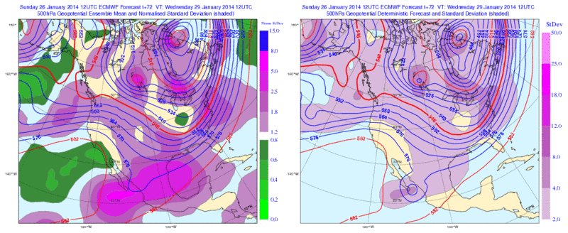
Looks like the 12zECMWF Ensemble Means want to eject the baja low much quicker than the operational run and as a result the Ensemble Means have some moisture to work with for South Texas.

Image
0 likes   
The following post is NOT an official forecast and should not be used as such. It is just the opinion of the poster and may or may not be backed by sound meteorological data. It is NOT endorsed by any professional institution including storm2k.org For Official Information please refer to the NHC and NWS products.

gpsnowman
S2K Supporter
S2K Supporter
Posts: 3214
Joined: Fri Jan 07, 2011 10:35 am
Location: Grand Prairie Tx

#5219 Postby gpsnowman » Sun Jan 26, 2014 3:44 pm

Steve McCauley seems to think our precipitation chances really get going in early February. Specifically the 3-6 time frame. :froze: What will the temps be? Time will tell.
0 likes   

User avatar
HouTXmetro
Category 5
Category 5
Posts: 3949
Joined: Sun Jun 13, 2004 6:00 pm
Location: District of Columbia, USA

Re:

#5220 Postby HouTXmetro » Sun Jan 26, 2014 3:45 pm

Rgv20 wrote:Looks like the 12zECMWF Ensemble Means want to eject the baja low much quicker than the operational run and as a result the Ensemble Means have some moisture to work with for South Texas.

Image


That would mean more moisture for all of us to work with :D
0 likes   
[Disclaimer: My Amateur Opinion, please defer to your local authorities or the NHC for Guidance.]


Return to “Winter Weather”

Who is online

Users browsing this forum: No registered users and 52 guests