Texas Winter 2013-2014
Moderator: S2k Moderators
Forum rules
 The posts in this forum are NOT official forecast and should not be used as such. They are just the opinion of the poster and may or may not be backed by sound meteorological data. They are NOT endorsed by any professional institution or STORM2K.
 The posts in this forum are NOT official forecast and should not be used as such. They are just the opinion of the poster and may or may not be backed by sound meteorological data. They are NOT endorsed by any professional institution or STORM2K.
-
BigB0882
- S2K Supporter

- Posts: 2291
- Joined: Thu Jul 03, 2003 12:08 am
- Location: Baton Rouge, LA
- Contact:
I don't know. I am looking on twister data and the amounts (snow accumulation) on the NAM through 42 hours are way less than the previous runs. So I don't know if it is seeing it as all snow. Otherwise why isn't it showing up in the twister data images? I have a feeling it is freezing rain. Or, worst of all, the NAM sees temps being too high for frozen precip at all which seems highly unlikely. This run is very odd.
0 likes
- TeamPlayersBlue
- Category 5

- Posts: 3524
- Joined: Tue Feb 02, 2010 1:44 am
- Location: Denver/Applewood, CO
Re:
BigB0882 wrote:I don't know. I am looking on twister data and the amounts (snow accumulation) on the NAM through 42 hours are way less than the previous runs. So I don't know if it is seeing it as all snow. Otherwise why isn't it showing up in the twister data images? I have a feeling it is freezing rain. Or, worst of all, the NAM sees temps being too high for frozen precip at all which seems highly unlikely. This run is very odd.
Not the case, temps are below freezing according to the 925 data
0 likes
Personal Forecast Disclaimer:
The posts in this forum are NOT official forecast and should not be used as such. They are just the opinion of the poster and may or may not be backed by sound meteorological data. They are NOT endorsed by any professional institution or storm2k.org. For official information, please refer to the NHC and NWS products.
The posts in this forum are NOT official forecast and should not be used as such. They are just the opinion of the poster and may or may not be backed by sound meteorological data. They are NOT endorsed by any professional institution or storm2k.org. For official information, please refer to the NHC and NWS products.
- cycloneye
- Admin

- Posts: 149184
- Age: 69
- Joined: Thu Oct 10, 2002 10:54 am
- Location: San Juan, Puerto Rico
Re:
southerngale wrote:How many inches?
Sent from my SCH-I535 using Tapatalk
That is sleet for you. About 0.50 to 1 inch.
0 likes
Visit the Caribbean-Central America Weather Thread where you can find at first post web cams,radars
and observations from Caribbean basin members Click Here
and observations from Caribbean basin members Click Here
Re:
BigB0882 wrote:I don't know. I am looking on twister data and the amounts (snow accumulation) on the NAM through 42 hours are way less than the previous runs. So I don't know if it is seeing it as all snow. Otherwise why isn't it showing up in the twister data images? I have a feeling it is freezing rain. Or, worst of all, the NAM sees temps being too high for frozen precip at all which seems highly unlikely. This run is very odd.
It is sleet, oodles of sleet for SE Texas and Louisiana

0 likes
The above post and any post by Ntxw is NOT an official forecast and should not be used as such. It is just the opinion of the poster and may or may not be backed by sound meteorological data. It is NOT endorsed by any professional institution including Storm2k. For official information, please refer to NWS products.
Re: Re:
TeamPlayersBlue wrote:BigB0882 wrote:I don't know. I am looking on twister data and the amounts (snow accumulation) on the NAM through 42 hours are way less than the previous runs. So I don't know if it is seeing it as all snow. Otherwise why isn't it showing up in the twister data images? I have a feeling it is freezing rain. Or, worst of all, the NAM sees temps being too high for frozen precip at all which seems highly unlikely. This run is very odd.
Not the case, temps are below freezing according to the 925 data
Temps above 925 are above freezing
Warm nose at 850

Last edited by Ntxw on Sun Jan 26, 2014 9:44 pm, edited 1 time in total.
0 likes
The above post and any post by Ntxw is NOT an official forecast and should not be used as such. It is just the opinion of the poster and may or may not be backed by sound meteorological data. It is NOT endorsed by any professional institution including Storm2k. For official information, please refer to NWS products.
Re: Texas Winter 2013-2014
Nam really buries what is left of the upper low way down in Mexico...
0 likes
- TeamPlayersBlue
- Category 5

- Posts: 3524
- Joined: Tue Feb 02, 2010 1:44 am
- Location: Denver/Applewood, CO
Re: Re:
Ntxw wrote:TeamPlayersBlue wrote:BigB0882 wrote:I don't know. I am looking on twister data and the amounts (snow accumulation) on the NAM through 42 hours are way less than the previous runs. So I don't know if it is seeing it as all snow. Otherwise why isn't it showing up in the twister data images? I have a feeling it is freezing rain. Or, worst of all, the NAM sees temps being too high for frozen precip at all which seems highly unlikely. This run is very odd.
Not the case, temps are below freezing according to the 925 data
Temps above 925 are above freezing
Warm nose at 850
Correct, but its frozen precip
0 likes
Personal Forecast Disclaimer:
The posts in this forum are NOT official forecast and should not be used as such. They are just the opinion of the poster and may or may not be backed by sound meteorological data. They are NOT endorsed by any professional institution or storm2k.org. For official information, please refer to the NHC and NWS products.
The posts in this forum are NOT official forecast and should not be used as such. They are just the opinion of the poster and may or may not be backed by sound meteorological data. They are NOT endorsed by any professional institution or storm2k.org. For official information, please refer to the NHC and NWS products.
- TeamPlayersBlue
- Category 5

- Posts: 3524
- Joined: Tue Feb 02, 2010 1:44 am
- Location: Denver/Applewood, CO
OK i see the image now. How deep can snow fall through before it melts? Any rule to follow? That warm nose looks fairly deep 
0 likes
Personal Forecast Disclaimer:
The posts in this forum are NOT official forecast and should not be used as such. They are just the opinion of the poster and may or may not be backed by sound meteorological data. They are NOT endorsed by any professional institution or storm2k.org. For official information, please refer to the NHC and NWS products.
The posts in this forum are NOT official forecast and should not be used as such. They are just the opinion of the poster and may or may not be backed by sound meteorological data. They are NOT endorsed by any professional institution or storm2k.org. For official information, please refer to the NHC and NWS products.
Re: Re:
TeamPlayersBlue wrote:Correct, but its frozen precipSo freezing at the surface, 850 is still north of Conroe. This is awesome but its sooooo close to being all snow. Any chance to precip can cool the warm nose? Or something.... IM DESPERATE!!!!!!
Frozen at the surface correct hence sleet. If it was just a little above freezing then the margin of error is ok. But it is showing 40s above which I don't think is quite freezing rain but supports sleet since it is of a good size up to 700mb. Assuming the NAM is correct.
0 likes
The above post and any post by Ntxw is NOT an official forecast and should not be used as such. It is just the opinion of the poster and may or may not be backed by sound meteorological data. It is NOT endorsed by any professional institution including Storm2k. For official information, please refer to NWS products.
- Rgv20
- S2K Supporter

- Posts: 2466
- Age: 39
- Joined: Wed Jan 05, 2011 5:42 pm
- Location: Edinburg/McAllen Tx
Re: Texas Winter 2013-2014
hriverajr wrote:Nam really buries what is left of the upper low way down in Mexico...
Is that a good set up for winter weather in the RGV? I'm guessing as long as the 500mb wind comes out of the SW for us we are in good shape with regards for moisture.
0 likes
The following post is NOT an official forecast and should not be used as such. It is just the opinion of the poster and may or may not be backed by sound meteorological data. It is NOT endorsed by any professional institution including storm2k.org For Official Information please refer to the NHC and NWS products.
-
Wntrwthrguy
- Tropical Storm

- Posts: 161
- Joined: Thu Nov 21, 2013 8:48 pm
- Location: North Austin
- TeamPlayersBlue
- Category 5

- Posts: 3524
- Joined: Tue Feb 02, 2010 1:44 am
- Location: Denver/Applewood, CO
Re: Re:
Ntxw wrote:TeamPlayersBlue wrote:Correct, but its frozen precipSo freezing at the surface, 850 is still north of Conroe. This is awesome but its sooooo close to being all snow. Any chance to precip can cool the warm nose? Or something.... IM DESPERATE!!!!!!
Frozen at the surface correct hence sleet. If it was just a little above freezing then the margin of error is ok. But it is showing 40s above which I don't think is quite freezing rain but supports sleet since it is of a good size up to 700mb. Assuming the NAM is correct.
With the precip going through a layer thats near -10C yeah, sleet i think. Oh man, not what i want. The precip doesnt seem to be as long as other models, like the longevitiy of the event.
0 likes
Personal Forecast Disclaimer:
The posts in this forum are NOT official forecast and should not be used as such. They are just the opinion of the poster and may or may not be backed by sound meteorological data. They are NOT endorsed by any professional institution or storm2k.org. For official information, please refer to the NHC and NWS products.
The posts in this forum are NOT official forecast and should not be used as such. They are just the opinion of the poster and may or may not be backed by sound meteorological data. They are NOT endorsed by any professional institution or storm2k.org. For official information, please refer to the NHC and NWS products.
Re: Re:
TeamPlayersBlue wrote:With the precip going through a layer thats near -10C yeah, sleet i think. Oh man, not what i want. The precip doesnt seem to be as long as other models, like the longevitiy of the event.
Yep if that panned out Houston will be a skating rink on Tuesday and probably stay shut down Wednesday. It will stick in the 20s.
0 likes
The above post and any post by Ntxw is NOT an official forecast and should not be used as such. It is just the opinion of the poster and may or may not be backed by sound meteorological data. It is NOT endorsed by any professional institution including Storm2k. For official information, please refer to NWS products.
Re: Texas Winter 2013-2014
That's a pretty significant warm nose the 0Z NAM is advertising compared to previous runs. Let's wait til the other 0Z models roll out before we give up on the snow.
0 likes
- Rgv20
- S2K Supporter

- Posts: 2466
- Age: 39
- Joined: Wed Jan 05, 2011 5:42 pm
- Location: Edinburg/McAllen Tx
0zNAM Forecast Simulated Radar lights up for Deep South Texas starting around 3AM to 9AM Wednesday Morning, temperatures will be a close call but none the less the 0zNAM calls for half an inch to 1 inch of Frozen Precipitation.
3AM Wednesday
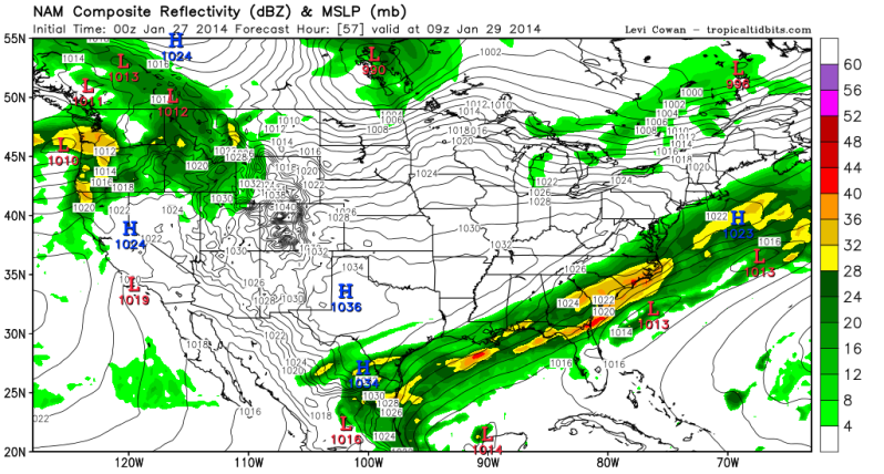
6AM
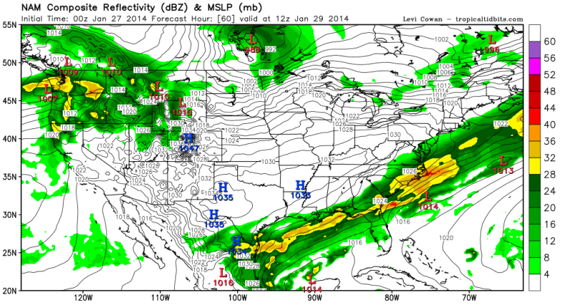
9AM
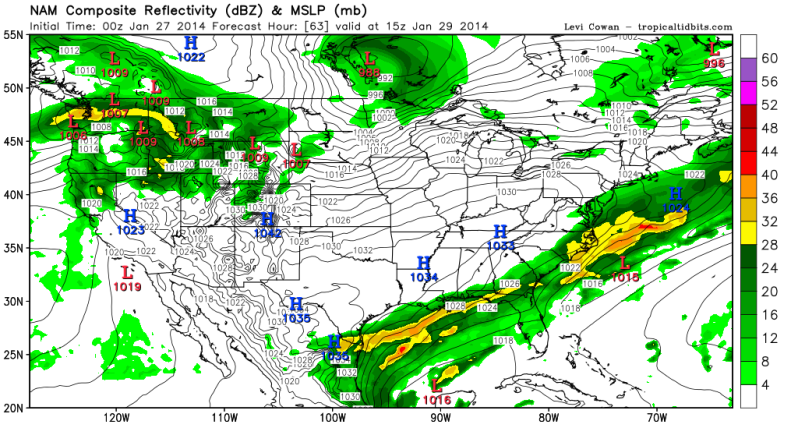
3AM Wednesday

6AM

9AM

0 likes
The following post is NOT an official forecast and should not be used as such. It is just the opinion of the poster and may or may not be backed by sound meteorological data. It is NOT endorsed by any professional institution including storm2k.org For Official Information please refer to the NHC and NWS products.
Re: Texas Winter 2013-2014
Hard to hang my hat on the NAM just yet. Need the GFS here in a few to hopefully provide some consensus. Tomorrow soundings will help....if / when the event gets near...UH release the balloons!!
0 likes
Re:
BigB0882 wrote:Is the NAM close to a 2 day event in that run or am I misunderstanding?
It's about a 18-24 hour event or a day. Heaviest stuff is Tuesday evening into midnight which the majority of the heavy stuff according to the model.
0 likes
The above post and any post by Ntxw is NOT an official forecast and should not be used as such. It is just the opinion of the poster and may or may not be backed by sound meteorological data. It is NOT endorsed by any professional institution including Storm2k. For official information, please refer to NWS products.
Re: Texas Winter 2013-2014
ROCK wrote:Hard to hang my hat on the NAM just yet. Need the GFS here in a few to hopefully provide some consensus. Tomorrow soundings will help....if / when the event gets near...UH release the balloons!!
Actually since yesterday evening the GFS has been showing a sleet storm for Houston, maybe ending with a little snow. No one bothered to check the soundings and just assumed it was snow. I don't think we'll see much change regarding that from that model.
0 likes
The above post and any post by Ntxw is NOT an official forecast and should not be used as such. It is just the opinion of the poster and may or may not be backed by sound meteorological data. It is NOT endorsed by any professional institution including Storm2k. For official information, please refer to NWS products.
- ThunderSleetDreams
- S2K Supporter

- Posts: 1510
- Age: 43
- Joined: Tue Dec 20, 2011 4:42 pm
- Location: S of Weimar, TX
Re: Texas Winter 2013-2014
This storm looks a lot like the Dallas storm from December. Houston metro should be an ice rink
0 likes
#NeverSummer
I hibernate when it gets above 75 degrees!
I hibernate when it gets above 75 degrees!
Who is online
Users browsing this forum: Stratton23, txtwister78 and 59 guests


