Texas Winter 2013-2014

Winter Weather Discussion

Moderator: S2k Moderators

Forum rules

The posts in this forum are NOT official forecast and should not be used as such. They are just the opinion of the poster and may or may not be backed by sound meteorological data. They are NOT endorsed by any professional institution or STORM2K.

Help Support Storm2K
Message
Author
aggiecutter
Category 5
Category 5
Posts: 1753
Joined: Thu Oct 14, 2004 9:22 pm
Location: Texarkana

Re: Texas Winter 2013-2014

#5581 Postby aggiecutter » Mon Jan 27, 2014 7:34 pm

HouTXmetro wrote:
ravyrn wrote:
HouTXmetro wrote:Colder temps filtering into South Central Louisiana Faster than East Texas... Lafayette is already down to 48 while Lufkin, TX is at 54. To the West San Antonio down to 48 while Huntsville, TX is at 53. Is there a reason cold temps are filtering into other areas faster then East/SE TX? Same thing happened last event.


I could be completely wrong, but I think the Ouachita Mountains help hold the dense shallow cold air back acting like a dam which may have caused it to progress a little slower past the Arklatex region. I think earlier in this thread a while back someone said as much.


Well that makes perfect sense.


That is very true, with particularly shallow arctic air masses. The Quachita mountain range is one of very few mountain ranges in North America that are orientated East to West. They run from Pinnacle Mountain just outside Little Rock, Arkansas to the Winding Stair Mountain range, just Northwest of Talihina, Oklahoma. Several of the peaks in West-Central Arkansas and Eastern Oklahoma run in the 2,600 foot range. Thus, depending upon the trajectory of the shallow arctic air, the air mass has trouble traversing the mountains.
0 likes   

User avatar
ROCK
Category 5
Category 5
Posts: 9492
Age: 54
Joined: Tue Aug 17, 2004 7:30 am
Location: Kemah, Texas

Re: Texas Winter 2013-2014

#5582 Postby ROCK » Mon Jan 27, 2014 8:11 pm

Roxy wrote:I usually only follow hurricanes, and at this point everyone would say...forget the models! Is it the same w/winter storms or is it really a bust? They have already canceled school, my boys really want to see some winter weather.

P. s. here in clear lake it is still relatively warm....


Here in Pearland....sitting at 57F and quite windy...not sure that is considered warm...lol....temps will drop...look at the current map above...-8 dewpoint in Dallas..lol I havent seen that in a long time. Not that I look very often in winter. :cheesy:
0 likes   

User avatar
South Texas Storms
Professional-Met
Professional-Met
Posts: 4245
Joined: Thu Jun 24, 2010 12:28 am
Location: Houston, TX

Re: Texas Winter 2013-2014

#5583 Postby South Texas Storms » Mon Jan 27, 2014 8:12 pm

It looks like the precip. is getting going a little earlier than the models forecasted as rain is currently developing just north of Del Rio. Bring on the surprises tonight!
0 likes   

ndale
Category 1
Category 1
Posts: 429
Joined: Tue Dec 29, 2009 11:12 am
Location: Pflugerville/Austin Tx

Re: Texas Winter 2013-2014

#5584 Postby ndale » Mon Jan 27, 2014 8:15 pm

South Texas Storms wrote:It looks like the precip. is getting going a little earlier than the models forecasted as rain is currently developing just north of Del Rio. Bring on the surprises tonight!


Did the models show the precip start developing in central Tx, is this starting further to the west than predicted?
0 likes   
Any opinions stated are those of an amateur, please take with several grains of salt and for official forecast refer to the National Weather Service.

User avatar
Roxy
S2K Supporter
S2K Supporter
Posts: 657
Joined: Mon Aug 16, 2004 7:58 am
Location: Houston (Clear Lake)

Re: Texas Winter 2013-2014

#5585 Postby Roxy » Mon Jan 27, 2014 8:19 pm

ROCK wrote:
Roxy wrote:I usually only follow hurricanes, and at this point everyone would say...forget the models! Is it the same w/winter storms or is it really a bust? They have already canceled school, my boys really want to see some winter weather.

P. s. here in clear lake it is still relatively warm....


Here in Pearland....sitting at 57F and quite windy...not sure that is considered warm...lol....temps will drop...look at the current map above...-8 dewpoint in Dallas..lol I havent seen that in a long time. Not that I look very often in winter. :cheesy:


I said relatively! :)

55 now, far cry from freezing.
0 likes   

User avatar
ROCK
Category 5
Category 5
Posts: 9492
Age: 54
Joined: Tue Aug 17, 2004 7:30 am
Location: Kemah, Texas

Re: Texas Winter 2013-2014

#5586 Postby ROCK » Mon Jan 27, 2014 8:22 pm

sleet in San Angelo? just reported.....uh oh.... :wink:
0 likes   

User avatar
Tireman4
S2K Supporter
S2K Supporter
Posts: 5858
Age: 60
Joined: Fri Jun 30, 2006 1:08 pm
Location: Humble, Texas
Contact:

Re: Texas Winter 2013-2014

#5587 Postby Tireman4 » Mon Jan 27, 2014 8:25 pm

ROCK wrote:sleet in San Angelo? just reported.....uh oh.... :wink:


The Hi Res NAM showed this. Woo Hoo...:)
0 likes   

User avatar
ROCK
Category 5
Category 5
Posts: 9492
Age: 54
Joined: Tue Aug 17, 2004 7:30 am
Location: Kemah, Texas

Re: Texas Winter 2013-2014

#5588 Postby ROCK » Mon Jan 27, 2014 8:26 pm

Port should be firing up the Prius right about now with that report.... :cheesy:
0 likes   

User avatar
Tireman4
S2K Supporter
S2K Supporter
Posts: 5858
Age: 60
Joined: Fri Jun 30, 2006 1:08 pm
Location: Humble, Texas
Contact:

Re: Texas Winter 2013-2014

#5589 Postby Tireman4 » Mon Jan 27, 2014 8:28 pm

Here in Pearland....sitting at 57F and quite windy...not sure that is considered warm...lol....temps will drop...look at the current map above...-8 dewpoint in Dallas..lol I havent seen that in a long time. Not that I look very often in winter. :cheesy:[/quote]


I said relatively! :)

55 now, far cry from freezing.[/quote]

Think of this as coming in waves. (Orangeblood and Ntwx can explain better than I can) The cold in coming in waves. One wave will lower it down degrees, then the next will. Be patient. It is coming...
0 likes   

User avatar
South Texas Storms
Professional-Met
Professional-Met
Posts: 4245
Joined: Thu Jun 24, 2010 12:28 am
Location: Houston, TX

Re: Texas Winter 2013-2014

#5590 Postby South Texas Storms » Mon Jan 27, 2014 8:28 pm

ndale wrote:
South Texas Storms wrote:It looks like the precip. is getting going a little earlier than the models forecasted as rain is currently developing just north of Del Rio. Bring on the surprises tonight!


Did the models show the precip start developing in central Tx, is this starting further to the west than predicted?


The precip is currently developing further west than the models predicted. They also showed the precip developing mainly after midnight, so this is about 6 hours ahead of schedule.
0 likes   

User avatar
Ntxw
Storm2k Moderator
Storm2k Moderator
Posts: 22894
Joined: Wed Oct 21, 2009 6:34 pm
Location: DFW, Texas

Re: Texas Winter 2013-2014

#5591 Postby Ntxw » Mon Jan 27, 2014 8:33 pm

South Texas Storms wrote:The precip is currently developing further west than the models predicted. They also showed the precip developing mainly after midnight, so this is about 6 hours ahead of schedule.


What model are you looking at? I'm looking at the 18z NAM had reflectivity showing up around 01-02UTC which is about this time just east of trans-pecos region..
0 likes   
The above post and any post by Ntxw is NOT an official forecast and should not be used as such. It is just the opinion of the poster and may or may not be backed by sound meteorological data. It is NOT endorsed by any professional institution including Storm2k. For official information, please refer to NWS products.

  Help support Storm2K!
Help Support Storm2K

User avatar
TheProfessor
Professional-Met
Professional-Met
Posts: 3506
Age: 29
Joined: Tue Dec 03, 2013 10:56 am
Location: Wichita, Kansas

#5592 Postby TheProfessor » Mon Jan 27, 2014 8:34 pm

There is a nice line of snow to the north Oklahoma city. Could this make it all the way down toward the metroplex?
Last edited by TheProfessor on Mon Jan 27, 2014 8:39 pm, edited 1 time in total.
0 likes   
An alumnus of The Ohio State University.

Your local National Weather Service office is your best source for weather information.

User avatar
Roxy
S2K Supporter
S2K Supporter
Posts: 657
Joined: Mon Aug 16, 2004 7:58 am
Location: Houston (Clear Lake)

Re: Texas Winter 2013-2014

#5593 Postby Roxy » Mon Jan 27, 2014 8:35 pm

Tireman4 wrote:Here in Pearland....sitting at 57F and quite windy...not sure that is considered warm...lol....temps will drop...look at the current map above...-8 dewpoint in Dallas..lol I havent seen that in a long time. Not that I look very often in winter. :cheesy:


I said relatively! :)

55 now, far cry from freezing.[/quote]

Think of this as coming in waves. (Orangeblood and Ntwx can explain better than I can) The cold in coming in waves. One wave will lower it down degrees, then the next will. Be patient. It is coming...[/quote]

Should I turn the pool on tonight? When are the freezing temps coming.

P.s. the wind is blowing, it is getting cold!
0 likes   

User avatar
South Texas Storms
Professional-Met
Professional-Met
Posts: 4245
Joined: Thu Jun 24, 2010 12:28 am
Location: Houston, TX

Re: Texas Winter 2013-2014

#5594 Postby South Texas Storms » Mon Jan 27, 2014 8:36 pm

Ntxw wrote:
South Texas Storms wrote:The precip is currently developing further west than the models predicted. They also showed the precip developing mainly after midnight, so this is about 6 hours ahead of schedule.


What model are you looking at? I'm looking at the 18z NAM had reflectivity showing up around 01-02UTC which is about this time just east of trans-pecos region..


Ah maybe the NAM did forecast it then. The GFS, RAP, and HRRR all start developing the precip after midnight.
0 likes   

davidiowx
Category 1
Category 1
Posts: 390
Joined: Tue Sep 10, 2013 11:07 am
Location: Richmond, TX

Re: Texas Winter 2013-2014

#5595 Postby davidiowx » Mon Jan 27, 2014 8:41 pm

South Texas Storms wrote:
ndale wrote:
South Texas Storms wrote:It looks like the precip. is getting going a little earlier than the models forecasted as rain is currently developing just north of Del Rio. Bring on the surprises tonight!


Did the models show the precip start developing in central Tx, is this starting further to the west than predicted?


The precip is currently developing further west than the models predicted. They also showed the precip developing mainly after midnight, so this is about 6 hours ahead of schedule.


To me that sounds like a possible bust. Especially in regards to Winter Storm Warning criteria. The precip is already developing and we are in the 50s and upper 40s. I have a feeling we may end up wet but without the accumulations to warrant a WSW. Things can change rapidly and I still hold hope but I definitely am not getting my hopes up. A surprise is not out of the question but looking less likely as we near the event.


This is my opinion. Not a forecast.
0 likes   

User avatar
Tireman4
S2K Supporter
S2K Supporter
Posts: 5858
Age: 60
Joined: Fri Jun 30, 2006 1:08 pm
Location: Humble, Texas
Contact:

Re: Texas Winter 2013-2014

#5596 Postby Tireman4 » Mon Jan 27, 2014 8:46 pm

[To me that sounds like a possible bust. Especially in regards to Winter Storm Warning criteria. The precip is already developing and we are in the 50s and upper 40s. I have a feeling we may end up wet but without the accumulations to warrant a WSW. Things can change rapidly and I still hold hope but I definitely am not getting my hopes up. A surprise is not out of the question but looking less likely as we near the event.


This is my opinion. Not a forecast.[/quote]

Think of the cold air coming in waves. We have seen the first, the next is coming and then the next. Second, look at the 18Z NAM. It is proving itself out right now. Be patient young grasshopper. Winter weather in Texas is tricky. Forecasting it is even harder. Do not believe me, ask the mets. They are pulling their hair out over this. Just be patient.
0 likes   

User avatar
TeamPlayersBlue
Category 5
Category 5
Posts: 3462
Joined: Tue Feb 02, 2010 1:44 am
Location: Denver/Applewood, CO

#5597 Postby TeamPlayersBlue » Mon Jan 27, 2014 8:52 pm

Right now watch the dewpoint. Temp right now means nothing till precip starts
0 likes   
Personal Forecast Disclaimer:
The posts in this forum are NOT official forecast and should not be used as such. They are just the opinion of the poster and may or may not be backed by sound meteorological data. They are NOT endorsed by any professional institution or storm2k.org. For official information, please refer to the NHC and NWS products.

User avatar
TeamPlayersBlue
Category 5
Category 5
Posts: 3462
Joined: Tue Feb 02, 2010 1:44 am
Location: Denver/Applewood, CO

Re:

#5598 Postby TeamPlayersBlue » Mon Jan 27, 2014 8:53 pm

TheProfessor wrote:There is a nice line of snow to the north Oklahoma city. Could this make it all the way down toward the metroplex?


Doubt it.
0 likes   
Personal Forecast Disclaimer:
The posts in this forum are NOT official forecast and should not be used as such. They are just the opinion of the poster and may or may not be backed by sound meteorological data. They are NOT endorsed by any professional institution or storm2k.org. For official information, please refer to the NHC and NWS products.

User avatar
Roxy
S2K Supporter
S2K Supporter
Posts: 657
Joined: Mon Aug 16, 2004 7:58 am
Location: Houston (Clear Lake)

Re: Texas Winter 2013-2014

#5599 Postby Roxy » Mon Jan 27, 2014 8:53 pm

Sounds like a bust. Guess I am glad they have already canceled school, just in case.

I still hope we see some sort of winter precip.
0 likes   

User avatar
Rgv20
S2K Supporter
S2K Supporter
Posts: 2466
Age: 39
Joined: Wed Jan 05, 2011 5:42 pm
Location: Edinburg/McAllen Tx

#5600 Postby Rgv20 » Mon Jan 27, 2014 8:53 pm

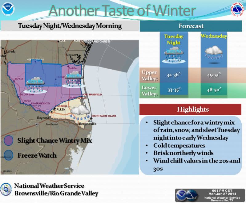
This is the 3rd Winter Weather threat for Deep South Texas, pretty impressive to say the least!

Image

Another blast of winter is in store for the Rio Grande Valley and Deep South Texas. Colder air will surge south across the region bringing below normal temperatures. A freeze watch has been issued for Jim Hogg and Brooks counties for Tuesday night into early Wednesday morning as temperatures may hit or dip just below freezing for a few hours. Precipitation chances increase as an upper level disturbance moves over the area and a coastal trough develops over the lower Texas coastal waters. There is a slight chance of a wintry mix of rain, snow, and sleet developing primarily for those areas north and west of the middle and lower Rio Grande Valley. No significant accumulations are expected. Residents are urged to monitor the latest forecasts and statements from the National Weather Service.
0 likes   
The following post is NOT an official forecast and should not be used as such. It is just the opinion of the poster and may or may not be backed by sound meteorological data. It is NOT endorsed by any professional institution including storm2k.org For Official Information please refer to the NHC and NWS products.


Return to “Winter Weather”

Who is online

Users browsing this forum: No registered users and 75 guests