Texas Winter 2013-2014
Moderator: S2k Moderators
Forum rules
 The posts in this forum are NOT official forecast and should not be used as such. They are just the opinion of the poster and may or may not be backed by sound meteorological data. They are NOT endorsed by any professional institution or STORM2K.

The posts in this forum are NOT official forecast and should not be used as such. They are just the opinion of the poster and may or may not be backed by sound meteorological data. They are NOT endorsed by any professional institution or STORM2K.
-
South Texas Storms

- Professional-Met

- Posts: 4258
- Joined: Thu Jun 24, 2010 12:28 am
- Location: Houston, TX
-
HouTXmetro

- Category 5

- Posts: 3949
- Joined: Sun Jun 13, 2004 6:00 pm
- Location: District of Columbia, USA
Re: Texas Winter 2013-2014
JDawg512 wrote:It is 26 degrees and dropping quickly from 34 degrees about 40 minutes ago here near South Central Austin. Rain is still falling and it is beginning to freeze on surfaces. I'm hoping it changes over soon. I checked two of my thermometers to make sure the 26 wasn't a fluke they both are reading 26 degrees.
26?! NO FREKIN WAY that is right. If that's the air filtering in now is EXTREMELY colder than expected.
0 likes
[Disclaimer: My Amateur Opinion, please defer to your local authorities or the NHC for Guidance.]

Re: Texas Winter 2013-2014
What kind of thermometers?
0 likes
Anything I post is my personal opinion and should not used for any type of planning or lifesaving reasons. Please refer to National Weather Service forecasts.
-
TeamPlayersBlue

- Category 5
- Posts: 3530
- Joined: Tue Feb 02, 2010 1:44 am
- Location: Denver/Applewood, CO
47.3F 27.5F, noooowwwww its starting to drop here. Finally. Dewpoint continuing to drop as well
0 likes
Personal Forecast Disclaimer:
The posts in this forum are NOT official forecast and should not be used as such. They are just the opinion of the poster and may or may not be backed by sound meteorological data. They are NOT endorsed by any professional institution or storm2k.org. For official information, please refer to the NHC and NWS products.
The posts in this forum are NOT official forecast and should not be used as such. They are just the opinion of the poster and may or may not be backed by sound meteorological data. They are NOT endorsed by any professional institution or storm2k.org. For official information, please refer to the NHC and NWS products.
-
South Texas Storms
- Professional-Met
- Posts: 4258
- Joined: Thu Jun 24, 2010 12:28 am
- Location: Houston, TX
Re: Texas Winter 2013-2014
Latest HRRR model is now showing about 1 inch of snow tonight just north of Brazos county.
0 likes
-
Longhornmaniac8

- Category 1

- Posts: 261
- Joined: Thu Nov 18, 2010 2:30 am
- Location: Austin, TX
-
Longhornmaniac8
- Category 1
- Posts: 261
- Joined: Thu Nov 18, 2010 2:30 am
- Location: Austin, TX
Re: Texas Winter 2013-2014
I'm assuming the precipitation on the radar is just the first wave, based on how early this seems to be?
0 likes
-
Rgv20

- S2K Supporter

- Posts: 2466
- Age: 39
- Joined: Wed Jan 05, 2011 5:42 pm
- Location: Edinburg/McAllen Tx
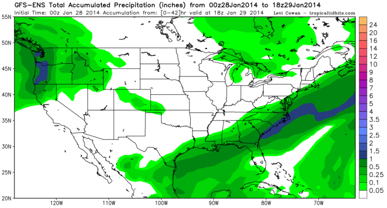
0zGFS Ensemble Mean Total Precipitation thru Midday Wednesday is between 0.25-0.50 for Deep South Texas and with temperatures expected to be near freezing this may end up as a pretty good winter weather for the Mid and Upper RGV! 

0 likes
The following post is NOT an official forecast and should not be used as such. It is just the opinion of the poster and may or may not be backed by sound meteorological data. It is NOT endorsed by any professional institution including storm2k.org For Official Information please refer to the NHC and NWS products.

Re: Texas Winter 2013-2014
Longhornmaniac8 wrote:I'm assuming the precipitation on the radar is just the first wave, based on how early this seems to be?
Yeah I am a little confused as well. Is there more to come?
0 likes
-
Rgv20
- S2K Supporter
- Posts: 2466
- Age: 39
- Joined: Wed Jan 05, 2011 5:42 pm
- Location: Edinburg/McAllen Tx
Model trends continue to look good! Below is the 0zUKMET precipitation forecast..
Precipitation forecast from 6pm to midnight Tuesday.
Precipitation forecast from Midnight to 6am Wednesday Morning.
Precipitation forecast from 6pm to midnight Tuesday.

Precipitation forecast from Midnight to 6am Wednesday Morning.

0 likes
The following post is NOT an official forecast and should not be used as such. It is just the opinion of the poster and may or may not be backed by sound meteorological data. It is NOT endorsed by any professional institution including storm2k.org For Official Information please refer to the NHC and NWS products.
-
South Texas Storms
- Professional-Met
- Posts: 4258
- Joined: Thu Jun 24, 2010 12:28 am
- Location: Houston, TX
Re: Texas Winter 2013-2014
Several reports of freezing rain are coming in from the Austin area. Pesky warm nose...
0 likes

Re: Texas Winter 2013-2014
jerryh421 wrote:Longhornmaniac8 wrote:I'm assuming the precipitation on the radar is just the first wave, based on how early this seems to be?
Yeah I am a little confused as well. Is there more to come?
At this point, it's wait and see. I did meteograms for various areas in SETX/SWLA and GFS is much drier. At this point, it's pretty much useless to check models. Time to pay attention to that moisture and see if it extends. The warm patch around Houston seems to diminishing quickly.
0 likes
-
Longhornmaniac8
- Category 1
- Posts: 261
- Joined: Thu Nov 18, 2010 2:30 am
- Location: Austin, TX
Definitely getting ice on elevated surfaces like chairs and lids of grills and such. At the moment it's a very light sleet/freezing rain combo, but the temperature continues to plummet and the dew point is on its way up. Up to 56% relative humidity now; temperature 31.3 and dew point 19.
Cheers,
Cameron
Cheers,
Cameron
0 likes
-
South Texas Storms
- Professional-Met
- Posts: 4258
- Joined: Thu Jun 24, 2010 12:28 am
- Location: Houston, TX
Re: Texas Winter 2013-2014
Updated Winter Weather Advisory from EWX:
"...WINTER WEATHER ADVISORY CONTINUES FOR MUCH OF SOUTH CENTRAL
TEXAS AND THE HILL COUNTRY FROM MIDNIGHT TONIGHT THROUGH NOON
TUESDAY...
.LIGHT RAIN MIXED WITH SLEET ARRIVED INTO SOUTH CENTRAL TEXAS
AHEAD OF PREVIOUSLY FORECAST...CAUSING A CHANGE IN THE EXPECTED
IMPACTS FOR LATE TONIGHT. THE EARLY ARRIVAL OF MOSTLY LIGHT RAIN
AND SOME SLEET RESULTED IN AN INCREASED POTENTIAL FOR FREEZING
RAIN AND A DECREASED POTENTIAL FOR ACCUMULATING SNOW IN THE
OVERNIGHT HOURS. THERE IS AN INCREASED POTENTIAL FOR LIGHT ICING
ON ROADWAYS THROUGH LATE TUESDAY MORNING...ESPECIALLY BRIDGES AND
OVERPASSES. THE RAIN AND FREEZING RAIN MIX IS STILL EXPECTED TO
CHANGE OVER TO A MIX OF LIGHT SLEET AND SNOW...BUT WITH LITTLE OR
NO ADDITIONAL ACCUMULATIONS EXPECTED. OVERNIGHT PRECIPITATION
RATES ARE EXPECTED TO BECOME EVEN LIGHTER THAN THEY WERE IN THE
EVENING HOURS...BUT THE WINTRY MIX OF RAIN...FREEZING RAIN...SLEET
AND SNOW COULD BRIEFLY INCREASE AGAIN AROUND DAYBREAK TUESDAY.
WINTER PRECIPITATION IS STILL EXPECTED TO END FROM THE NORTHWEST
LATE TUESDAY MORNING...AND END ACROSS ALL AREAS BY LATE TUESDAY
AFTERNOON. WIND CHILLS WILL REMAIN THE TEENS AND 20S AT TIMES
THROUGH DAYBREAK TUESDAY."
0 likes
-
weatherdude1108
- Category 5
- Posts: 4228
- Joined: Tue Dec 13, 2011 1:04 pm
- Location: Northwest Austin/Cedar Park, TX
In reference to my 35 and ice post, the thermometer is under an eve, 20 feet or so above the ground. The rain gauge and playhouse are on the ground (but slightly elevated) . No ice yet on patio furniture or grass, or patio surface.
The house is in kind of a low spot topographically. My guess is the surface temperature is a few degrees colder than where the temperature sensor is. Similar principle to seeing frost at 37 degrees. Or the sensor is off.
Update: Now 31 degrees. Dropped fast! 
Got a text just now that my work is delayed two hours tomorrow. Second "ice day" in five days. Amazing!
The house is in kind of a low spot topographically. My guess is the surface temperature is a few degrees colder than where the temperature sensor is. Similar principle to seeing frost at 37 degrees. Or the sensor is off.
Update: Now 31 degrees.
Got a text just now that my work is delayed two hours tomorrow. Second "ice day" in five days. Amazing!
Last edited by weatherdude1108 on Tue Jan 28, 2014 12:56 am, edited 1 time in total.
0 likes
-
Rgv20
- S2K Supporter
- Posts: 2466
- Age: 39
- Joined: Wed Jan 05, 2011 5:42 pm
- Location: Edinburg/McAllen Tx
0zCMC mostly has Sleet as the main Winter Precip..
Sleet Accumulations
Snow Accumulations
Sleet Accumulations

Snow Accumulations

0 likes
The following post is NOT an official forecast and should not be used as such. It is just the opinion of the poster and may or may not be backed by sound meteorological data. It is NOT endorsed by any professional institution including storm2k.org For Official Information please refer to the NHC and NWS products.
-
HouTXmetro
- Category 5
- Posts: 3949
- Joined: Sun Jun 13, 2004 6:00 pm
- Location: District of Columbia, USA
Wow, this was not expected.. I don't know if it's hitting the ground but Moisture is streaming into the DFW Metroplex
http://radar.weather.gov/Conus/southplains_loop.php
http://radar.weather.gov/Conus/southplains_loop.php
0 likes
[Disclaimer: My Amateur Opinion, please defer to your local authorities or the NHC for Guidance.]
Re:
HouTXmetro wrote:Wow, this was not expected.. I don't know if it's hitting the ground but Moisture is streaming into the DFW Metroplex
http://radar.weather.gov/Conus/southplains_loop.php
Those are very light echos, given the dew points, I doubt it.
0 likes
-
Houstonia

- S2K Supporter
- Posts: 829
- Age: 61
- Joined: Fri Oct 11, 2002 9:45 am
- Location: Sharpstown, Houston, Harris County, Southeast Texas.
Re: Texas Winter 2013-2014
around 46 and there's something floating in the air - it looks like a super-fine drizzle - so fine that it's not leaving any water residue on the ground, but can be seen when I flash my flashlight into the dark backyard.
It's very damp here, but very little wind. winter clouds in the sky.
It's very damp here, but very little wind. winter clouds in the sky.
0 likes
-
South Texas Storms
- Professional-Met
- Posts: 4258
- Joined: Thu Jun 24, 2010 12:28 am
- Location: Houston, TX
Re: Texas Winter 2013-2014
0z Euro is a lot wetter for you as well Rgv. The trend is your friend tonight!
0 likes
Who is online
Users browsing this forum: No registered users and 44 guests