Texas Winter 2013-2014
Moderator: S2k Moderators
Forum rules
 The posts in this forum are NOT official forecast and should not be used as such. They are just the opinion of the poster and may or may not be backed by sound meteorological data. They are NOT endorsed by any professional institution or STORM2K.

The posts in this forum are NOT official forecast and should not be used as such. They are just the opinion of the poster and may or may not be backed by sound meteorological data. They are NOT endorsed by any professional institution or STORM2K.
-
SaskatchewanScreamer
-
Rgv20

- S2K Supporter

- Posts: 2466
- Age: 39
- Joined: Wed Jan 05, 2011 5:42 pm
- Location: Edinburg/McAllen Tx
Winter Storm Warning Issued for all of the Rio Grande Valley!
URGENT - WINTER WEATHER MESSAGE
NATIONAL WEATHER SERVICE BROWNSVILLE TX
1128 PM CST TUE JAN 28 2014
...DANGEROUS TRAVEL CONDITIONS AND WIND CHILLS OVERNIGHT TONIGHT...
.AREAS OF SLEET AND FREEZING RAIN ARE EXPECTED ACROSS THE RIO
GRANDE VALLEY AND DEEP SOUTH TEXAS. AS TEMPERATURES FALL...ICE
ACCRETION FROM FREEZING RAIN AND SLEET IS EXPECTED. THIS WILL
CREATE VERY HAZARDOUS TRAVEL CONDITIONS ACROSS THE REGION.
ADDITIONALLY DANGEROUS COLD WIND CHILL VALUES ARE EXPECTED THROUGH THE
OVERNIGHT HOURS AND INTO EARLY WEDNESDAY MORNING.
TXZ251>257-291330-
/O.UPG.KBRO.WW.Y.0002.140129T0600Z-140129T1400Z/
/O.NEW.KBRO.WS.W.0001.140129T0528Z-140129T1400Z/
/O.CON.KBRO.WC.Y.0004.000000T0000Z-140129T1700Z/
KENEDY-STARR-HIDALGO-INLAND WILLACY-INLAND CAMERON-
COASTAL WILLACY-COASTAL CAMERON-
INCLUDING THE CITIES OF...SARITA...RIO GRANDE CITY...ROMA...
MCALLEN...EDINBURG...PHARR...MISSION...WESLACO...RAYMONDVILLE...
BROWNSVILLE...HARLINGEN...PORT MANSFIELD...PORT ISABEL...
SOUTH PADRE ISLAND...LAGUNA HEIGHTS...LAGUNA VISTA
1128 PM CST TUE JAN 28 2014
...WINTER STORM WARNING IN EFFECT UNTIL 8 AM CST WEDNESDAY...
...WIND CHILL ADVISORY REMAINS IN EFFECT UNTIL 11 AM CST
WEDNESDAY...
THE NATIONAL WEATHER SERVICE IN BROWNSVILLE HAS ISSUED A WINTER
STORM WARNING FOR FREEZING RAIN AND SLEET...WHICH IS IN EFFECT
UNTIL 8 AM CST WEDNESDAY. THE WINTER WEATHER ADVISORY IS NO
LONGER IN EFFECT.
* EVENT...STRONG COLD ARCTIC AIR BRINGING BELOW FREEZING
TEMPERATURES TONIGHT IN COMBINATION WITH A DISTURBANCE OVER
MEXICO WILL DEVELOP THE POTENTIAL FOR A MIX OF FREEZING RAIN AND
SLEET ACROSS DEEP SOUTH TEXAS. ICE ACCRETION OVER ONE EIGHT OF
AN INCH AND SLEET ACCUMULATION TO ONE HALF TO THREE QUARTERS OF
AN INCH ARE EXPECTED.
* WIND CHILL VALUES...23 TO 26 ACROSS THE RIO GRANDE RANCH LANDS
AND 25 TO 28 ACROSS THE RIO GRANDE VALLEY.
* TIMING...NOW THROUGH EARLY WEDNESDAY MORNING.
* IMPACT...TRAVEL IN MANY AREAS ACROSS THE RIO GRANDE VALLEY WILL
BE SIGNFICANTLY IMPACTED...ESPECIALLY ON BRIDGES AND OVERPASSES
WITH SLICK SPOTS FORMING. HYPOTHERMIA COULD DEVELOP QUICKLY IN
PERSONS AND ANIMALS THAT ARE WITHOUT ADEQUATE SHELTER. THOSE
OUTDOORS FOR EXTENDED PERIODS OF TIME SHOULD BE ADEQUATELY
DRESSED IN MULTIPLE LAYERS.
PRECAUTIONARY/PREPAREDNESS ACTIONS...
PRECAUTIONARY/PREPAREDNESS ACTIONS...
A WINTER STORM WARNING IS ISSUED WHEN DANGEROUS WINTER WEATHER IS
IMMINENT. SNOW ACCUMULATIONS OF AT LEAST ONE INCH ON ROADS OR
WALKWAYS...AT LEAST ONE HALF INCH OF SLEET ACCUMULATION...OR ICE
ACCRETION OF ONE EIGHTH INCH OR MORE ON EXPOSED SURFACES.
HAZARDOUS DRIVING CONDITIONS WILL RESULT. PERSONS WITH TRAVEL
PLANS IN THE WARNING AREA ARE STRONGLY ENCOURAGED TO POSTPONE
THEM UNTIL CONDITIONS IMPROVE.
A WIND CHILL ADVISORY IS ISSUED WHEN WIND CHILL INDEX VALUES WILL
DROP TO 30 OR LOWER FOR AT LEAST 2 HOURS FOR THE RIO GRANDE
VALLEY AND 25 DEGREES OR LOWER FOR 2 OR MORE HOURS FOR THE RIO
GRANDE PLAINS AND NORTHERN RANCHLANDS...WITH WINDS OF 10 MPH OR
GREATER.
&&
$$
JGG/TS/JT
0 likes
The following post is NOT an official forecast and should not be used as such. It is just the opinion of the poster and may or may not be backed by sound meteorological data. It is NOT endorsed by any professional institution including storm2k.org For Official Information please refer to the NHC and NWS products.
-
Rgv20
- S2K Supporter
- Posts: 2466
- Age: 39
- Joined: Wed Jan 05, 2011 5:42 pm
- Location: Edinburg/McAllen Tx
AREA FORECAST DISCUSSION
NATIONAL WEATHER SERVICE BROWNSVILLE TX
1142 PM CST TUE JAN 28 2014
.DISCUSSION...06Z SOUNDING DATA REVEALED ABOUT A 4000 FT LAYER OF
ABOVE FREEZING TEMPERATURES AT AROUND 800MB WITH A MAXIMUM WARM
LAYER TEMPERATURE AROUND 5 TO 6 DEGREES C. THIS WAS A MORE
FAVORABLE PROFILE FOR FREEZING RAIN THAN ORIGINALLY EXPECTED. WITH
INCREASING RETURNS OVER THE AREA TO THE SOUTHWEST AND AN UPPER LOW
STILL SEVERAL HOURS AWAY PRODUCING LIFT IN CONCERT WITH LOW LEVEL
FRONTOGENETIC FORCING HAVE REPLACED THE WINTER WEATHER ADVISORY
WITH A WINTER STORM WARNING FOR ABOUT 1/8 TO 1/4 INCH OF FREEZING
RAIN GLAZE AND AROUND ONE HALF TO ONE INCH OF SLEET ACCRETION.
SNOW OF ONE INCH OR MORE IS AT LEAST A POSSIBILITY IN THE COLDER
AIR OVER ZAPATA AND JIM HOGG COUNTY BUT LIKELY WILL STILL BE MORE
OF THE ICE VARIETY.
PRECIP FALLING THROUGH THE DRY LOWEST 4000 FT OR SO IS PRODUCING A
STRONG WET BULB COOLING EFFECT ON THE LOWEST PORTION OF THE
ATMOSPHERE AND TEMPS IN HIDALGO COUNTY HAVE FALLEN ABOUT 4 DEGREES
IN THE LAST COUPLE OF HOURS AND SHOULD AT THAT RATE FALL BELOW
FREEZING SHORTLY. WSW PRODUCT OUT AND GRIDS WILL BE REWORKED VERY
SHORTLY. /68-JGG/
0 likes
The following post is NOT an official forecast and should not be used as such. It is just the opinion of the poster and may or may not be backed by sound meteorological data. It is NOT endorsed by any professional institution including storm2k.org For Official Information please refer to the NHC and NWS products.
-
Rgv20
- S2K Supporter
- Posts: 2466
- Age: 39
- Joined: Wed Jan 05, 2011 5:42 pm
- Location: Edinburg/McAllen Tx
http://www.krgv.com/news/txdot-closes-expressway/
PHARR - Texas Department of Transportation crews have closed the expressway as weather conditions continue to worsen in the Rio Grande Valley.
U.S. 83 will be temporarily closed from Mission to Brownsville and U.S. 281 will be closed south of Edinburg.
TxDOT said crews will continue to monitor the roads throughout the night and will reopen them when it is safe to do so.
0 likes
The following post is NOT an official forecast and should not be used as such. It is just the opinion of the poster and may or may not be backed by sound meteorological data. It is NOT endorsed by any professional institution including storm2k.org For Official Information please refer to the NHC and NWS products.
-
orangeblood
- S2K Supporter
- Posts: 3895
- Joined: Tue Dec 15, 2009 6:14 pm
- Location: Fort Worth, TX
Re: Texas Winter 2013-2014
European goes wild with a massive snowstorm for the panhandle into North Texas middle of next week, brings the system in slower and further south into Mexico - in fact I'm not sure I've ever seen a storm, that deep, come negative tilt through Texas from that direction ? Canadian is similar, both models are much slower with the 2nd system late next week (digs the upper low into northern Baja), might bode well for more of an overrunning type setup if that were to verify - strong HP filtering in from the north with impulses coming out in southwest flow.
GFS is much faster and further north with the 2nd system
GFS is much faster and further north with the 2nd system
0 likes
-
Rgv20
- S2K Supporter
- Posts: 2466
- Age: 39
- Joined: Wed Jan 05, 2011 5:42 pm
- Location: Edinburg/McAllen Tx
AREA FORECAST DISCUSSION...UPDATED
NATIONAL WEATHER SERVICE BROWNSVILLE TX
157 AM CST WED JAN 29 2014
.DISCUSSION...NUMEROUS REPORTS OF ICE GLAZE ACROSS THE CWA OVER
THE LAST TWO HOURS...PARTICULARLY IN THE RIO GRANDE VALLEY METRO
AREAS. 2M TEMPS ARE RIGHT AT 32 IN MOST PLACES WITH IMMEDIATE
SURFACES LOWER. STRONG MID LEVEL ASCENT AND LOW LEVEL
FRONTOGENETIC FORCING CONTINUES AND EXPECTING AT LEAST ANOTHER 4
TO 5 HOURS OF RAINFALL/SLEET OVER THE AREA THROUGH THE NIGHT. AS
MID LEVEL LIFT INCREASES WITH THE APPROACH OF THE UPPER LOW BY 7
TO 9 AM MID LEVEL TEMPS SHOULD COOL TO THE POINT THAT A CHANGEOVER
TO MORE SLEET/SNOW IS POSSIBLE. LESS PRECIP/EVAPORATIVE COOLING AT
HBV/BKS HAS KEPT TEMPS WARMER THERE BUT PRECIP OF ANY SIGNIFICANCE
WILL LOWER TEMPS QUICKLY. ANOTHER 0.10 TO 0.25 INCHES OF FREEZING
RAIN IS POSSIBLE ON TOP OF AMOUNTS ALREADY RECEIVED. STILL
EXPECTING A QUICK WARMUP BY AROUND 8 AM WITH TRAVEL PROBLEMS/ICE
ACCUMULATION REDUCING FAIRLY QUICKLY. /68-JGG/
Edit:3AM here and its 34F Raining at a pretty good clip, I can also hear some Sleet. PS I put the alarm at 2:20AM lol
0 likes
The following post is NOT an official forecast and should not be used as such. It is just the opinion of the poster and may or may not be backed by sound meteorological data. It is NOT endorsed by any professional institution including storm2k.org For Official Information please refer to the NHC and NWS products.


Re: Texas Winter 2013-2014
orangeblood wrote:European goes wild with a massive snowstorm for the panhandle into North Texas middle of next week, brings the system in slower and further south into Mexico - in fact I'm not sure I've ever seen a storm, that deep, come negative tilt through Texas from that direction ? Canadian is similar, both models are much slower with the 2nd system late next week (digs the upper low into northern Baja), might bode well for more of an overrunning type setup if that were to verify - strong HP filtering in from the north with impulses coming out in southwest flow.
GFS is much faster and further north with the 2nd system
The Euro lays down up to a foot of snow between the two systems for much of the northern half of the state.
0 likes
The above post and any post by Ntxw is NOT an official forecast and should not be used as such. It is just the opinion of the poster and may or may not be backed by sound meteorological data. It is NOT endorsed by any professional institution including Storm2k. For official information, please refer to NWS products.
Help support Storm2K!
-
srainhoutx

- S2K Supporter
- Posts: 6919
- Age: 68
- Joined: Sun Jan 14, 2007 11:34 am
- Location: Haywood County, NC
- Contact:
Re: Texas Winter 2013-2014
The overnight guidance continues to advertise a synoptic pattern change from that of a Western Ridge/Eastern trough to a pattern that becomes more zonal with a split flow developing across the Western half of the Lower 48. Changes begin to lurk near the Day 4-5 time frame as differences are seen via the operation GFS and Euro. The guidance generally agree that a upper air disturbance drops S into Northern Mexico as the 500MB trough pattern shifts back to the W and a positive trough regime develops from the Desert SW on NE across New Mexico into the Upper Mid West. The Global models suggest a upper low will drop S into Mexico, but the GFS shears out this feature while the Euro suggests a stronger more closed core low.
It does appear that a weak cold front will push S and stall near the Coast increasing our rain chances by Friday. As the front stalls, a Coastal wave develops allowing over running light to moderate rain to spread N into Central and SE Texas and Louisiana. The SPC does mention the potential for stronger storms to develop across the NW Gulf Region as lee side cyclogenesis becomes possible as that upper low ejects from Mexico into the Southern Plains around a week from today or next Tuesday. As is typical with any synoptic large scale pattern change, there tends to be a great deal of run to run volatility but it does appear we are transitioning to a pattern that will increase our rain chances across Central/N/ SE Texas and on E where dry conditions have plagued our Region since the pesky NW flow aloft developed. As the pattern further changes to that of a trough across the West and a SE Ridge, additional storminess is suggested as very cold air pools across Western Canada into the Inter Mountain West and Plains as Pacific storms drop S into California and the Baja Region of NW Mexico and tap Eastern Pacific moisture. This type of pattern in early February tends to suggest a very unsettled weather pattern with cold air intrusions into our Region as Winter Storms wrap up across the Southern Plains and pull much colder air S from Western Canada. The storm track also tends to favor dropping heavy snow across the Plains that has been lacking and adding to less air mass modification as the very cold air pushes S. Time will tell, but the pattern suggests we have not seen the last of wintry mischief across our Region extending back into New Mexico, The Panhandle/Central N and Eastern Texas as well as Oklahoma. We will see.
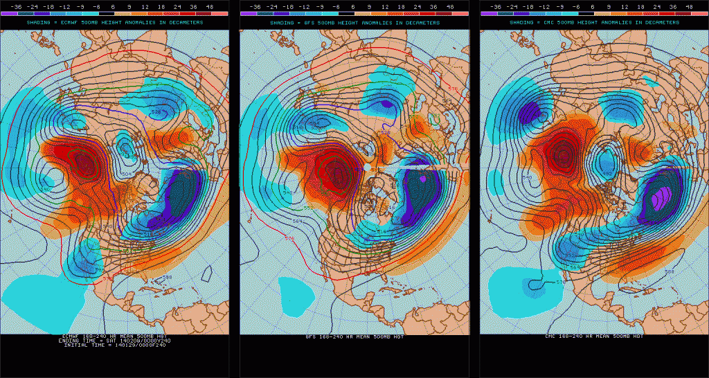
It does appear that a weak cold front will push S and stall near the Coast increasing our rain chances by Friday. As the front stalls, a Coastal wave develops allowing over running light to moderate rain to spread N into Central and SE Texas and Louisiana. The SPC does mention the potential for stronger storms to develop across the NW Gulf Region as lee side cyclogenesis becomes possible as that upper low ejects from Mexico into the Southern Plains around a week from today or next Tuesday. As is typical with any synoptic large scale pattern change, there tends to be a great deal of run to run volatility but it does appear we are transitioning to a pattern that will increase our rain chances across Central/N/ SE Texas and on E where dry conditions have plagued our Region since the pesky NW flow aloft developed. As the pattern further changes to that of a trough across the West and a SE Ridge, additional storminess is suggested as very cold air pools across Western Canada into the Inter Mountain West and Plains as Pacific storms drop S into California and the Baja Region of NW Mexico and tap Eastern Pacific moisture. This type of pattern in early February tends to suggest a very unsettled weather pattern with cold air intrusions into our Region as Winter Storms wrap up across the Southern Plains and pull much colder air S from Western Canada. The storm track also tends to favor dropping heavy snow across the Plains that has been lacking and adding to less air mass modification as the very cold air pushes S. Time will tell, but the pattern suggests we have not seen the last of wintry mischief across our Region extending back into New Mexico, The Panhandle/Central N and Eastern Texas as well as Oklahoma. We will see.
Last edited by srainhoutx on Wed Jan 29, 2014 9:14 am, edited 2 times in total.
0 likes
Carla/Alicia/Jerry(In The Eye)/Michelle/Charley/Ivan/Dennis/Katrina/Rita/Wilma/Ike/Harvey
Member: National Weather Association
Wx Infinity Forums
http://wxinfinity.com/index.php
Facebook.com/WeatherInfinity
Twitter @WeatherInfinity
Member: National Weather Association
Wx Infinity Forums
http://wxinfinity.com/index.php
Facebook.com/WeatherInfinity
Twitter @WeatherInfinity
16F this morning currently at the North Texas Branch of PWC for what is the 4th time from different air masses into the teens.
0 likes
The above post and any post by Ntxw is NOT an official forecast and should not be used as such. It is just the opinion of the poster and may or may not be backed by sound meteorological data. It is NOT endorsed by any professional institution including Storm2k. For official information, please refer to NWS products.
Help support Storm2K!
Help support Storm2K!

Re: Texas Winter 2013-2014
Very frustrating to watch as a v shaped dry slot enveloped my area yesterday, flurries to the n and nw in arkansas and snow 100 or so miles to the south. Im hoping that this next round next week treats us better but what im really afraid of is that we will end up getting primed for ice.
0 likes

-
wxman57

- Moderator-Pro Met

- Posts: 23174
- Age: 68
- Joined: Sat Jun 21, 2003 8:06 pm
- Location: Houston, TX (southwest)
Re: Texas Winter 2013-2014
All the way down to 30 in Houston. That's quite cold enough. Looking forward to 70s Fri/Sat.
0 likes
-
Tireman4

- S2K Supporter
- Posts: 5903
- Age: 60
- Joined: Fri Jun 30, 2006 1:08 pm
- Location: Humble, Texas
- Contact:
Re: Texas Winter 2013-2014
wxman57 wrote:All the way down to 30 in Houston. That's quite cold enough. Looking forward to 70s Fri/Sat.
Are you still showing the Upside map of yours for next week? LOL
0 likes
-
CaptinCrunch

- S2K Supporter
- Posts: 8779
- Age: 58
- Joined: Mon Nov 03, 2003 4:33 pm
- Location: Kennedale, TX (Tarrant Co.)
-
TheProfessor

- Professional-Met

- Posts: 3506
- Age: 29
- Joined: Tue Dec 03, 2013 10:56 am
- Location: Wichita, Kansas
-
gboudx

- S2K Supporter
- Posts: 4090
- Joined: Thu Sep 04, 2003 1:39 pm
- Location: Rockwall, Tx but from Harvey, La
Re:
texas1836 wrote:Low of 10 degrees at the DWC in McKinney this morning. The air must be a bit warmer above and coldest shallow, it fluctuated from 10 to 13 degrees quite regularly in short periods of time.
Interesting because I saw the same thing with my weather station. It was 16, then went to 20, then down to 18. All within about 30 mins which doesn't make any sense. I was thinking it's having issues and maybe I need to replace the battery.
On a positive note, the dewpoint is up to 14. C'mon moisture!
0 likes
-
wxman57
- Moderator-Pro Met
- Posts: 23174
- Age: 68
- Joined: Sat Jun 21, 2003 8:06 pm
- Location: Houston, TX (southwest)
Re: Texas Winter 2013-2014
Tireman4 wrote:wxman57 wrote:All the way down to 30 in Houston. That's quite cold enough. Looking forward to 70s Fri/Sat.
Are you still showing the Upside map of yours for next week? LOL
00Z Euro shifted the snow north to the sothern Panhandle through Dallas/Ft. Worth next Tue/Wed. Up to a foot of snow in the D-FW area from 6pm Tue to 6pm Wed. Over 20" farther east. Note that the contours are in 5cm intervals. 2.5cm = 1 inch, 10cm = 5 inches, 25cm = 10 inches, etc. Note that the 00Z GFS is quite different from the Euro - worlds apart in fact.

0 likes
Re: Re:
gboudx wrote:texas1836 wrote:Low of 10 degrees at the DWC in McKinney this morning. The air must be a bit warmer above and coldest shallow, it fluctuated from 10 to 13 degrees quite regularly in short periods of time.
Interesting because I saw the same thing with my weather station. It was 16, then went to 20, then down to 18. All within about 30 mins which doesn't make any sense. I was thinking it's having issues and maybe I need to replace the battery.
On a positive note, the dewpoint is up to 14. C'mon moisture!
I noticed on my way out a high level cloud deck, I think that may have something to do with it.
Some gossip and chatter of secret files within the bustling PWC HQ. Papers and charts labeled "Operation Glaciation" were rumored to have been seen. Perhaps our field reporter Texas Snowman or loyal TV channel viewer Tireman4 may have some insight!
0 likes
The above post and any post by Ntxw is NOT an official forecast and should not be used as such. It is just the opinion of the poster and may or may not be backed by sound meteorological data. It is NOT endorsed by any professional institution including Storm2k. For official information, please refer to NWS products.
Help support Storm2K!
Help support Storm2K!

Re: Texas Winter 2013-2014
wxman57 wrote:Tireman4 wrote:wxman57 wrote:All the way down to 30 in Houston. That's quite cold enough. Looking forward to 70s Fri/Sat.
Are you still showing the Upside map of yours for next week? LOL
00Z Euro shifted the snow north to the sothern Panhandle through Dallas/Ft. Worth next Tue/Wed. Up to a foot of snow in the D-FW area from 6pm Tue to 6pm Wed. Over 20" farther east. Note that the contours are in 5cm intervals. 2.5cm = 1 inch, 10cm = 5 inches, 25cm = 10 inches, etc. Note that the 00Z GFS is quite different from the Euro - worlds apart in fact.
http://home.comcast.net/~cgh57/eurosnow.gif
I will be heading North next week if this forecast continues to verfify!
0 likes
Any forecast I make is based on my opinion only. Please refer to the NWS or NHC for official forecasts.
Who is online
Users browsing this forum: No registered users and 55 guests