Texas Winter 2013-2014
Moderator: S2k Moderators
Forum rules
 The posts in this forum are NOT official forecast and should not be used as such. They are just the opinion of the poster and may or may not be backed by sound meteorological data. They are NOT endorsed by any professional institution or STORM2K.

The posts in this forum are NOT official forecast and should not be used as such. They are just the opinion of the poster and may or may not be backed by sound meteorological data. They are NOT endorsed by any professional institution or STORM2K.
-
Texas Snowman

- Storm2k Moderator

- Posts: 6197
- Joined: Fri Jan 25, 2008 11:29 am
- Location: Denison, Texas
0 likes
The above post and any post by Texas Snowman is NOT an official forecast and should not be used as such. It is just the opinion of the poster and may or may not be backed by sound meteorological data. It is NOT endorsed by any professional institution including storm2k.org. For official information, please refer to NWS products.

Ah yes the seesaw, got to love it. One month anniversary of winter cancels this week from last month, any takers? Here's a thought mid to end of January western Canada was 20-40F above normal! If the EPO wants cold it will find cold 
0 likes
The above post and any post by Ntxw is NOT an official forecast and should not be used as such. It is just the opinion of the poster and may or may not be backed by sound meteorological data. It is NOT endorsed by any professional institution including Storm2k. For official information, please refer to NWS products.
Help support Storm2K!
-
TheProfessor

- Professional-Met

- Posts: 3506
- Age: 29
- Joined: Tue Dec 03, 2013 10:56 am
- Location: Wichita, Kansas
-
Tireman4

- S2K Supporter

- Posts: 5904
- Age: 60
- Joined: Fri Jun 30, 2006 1:08 pm
- Location: Humble, Texas
- Contact:
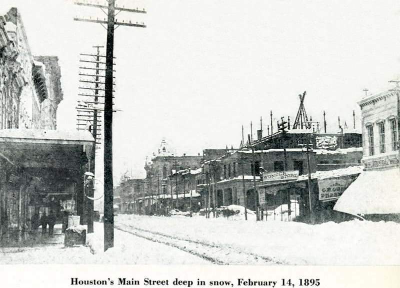
To whet the snow lovers delight in Houston and to post a negative -WSI (for Wxman57). Today marks the anniversary of the BIG one in Houston. That is right, the infamous Valentine's Day Snowstorm in Houston.
http://photos1.blogger.com/blogger/6964 ... ow1895.jpg
http://photos1.blogger.com/blogger/6964 ... ow1895.jpg
0 likes
-
TheProfessor
- Professional-Met
- Posts: 3506
- Age: 29
- Joined: Tue Dec 03, 2013 10:56 am
- Location: Wichita, Kansas
0 likes
An alumnus of The Ohio State University.
Your local National Weather Service office is your best source for weather information.
Your local National Weather Service office is your best source for weather information.
-
texas1836
- Tropical Storm

- Posts: 223
- Age: 55
- Joined: Fri Aug 17, 2012 10:10 am
- Location: Ruidoso, New Mexico
Re: Texas Winter 2013-2014
JDawg512 wrote:weatherdude1108 wrote:Interesting about the plants! I noticed the Pink Indigo potted plant I brought into the garage several weeks ago has sprouted new leaves. The garage has no windows!It's like they have this internal circadian rhythm and can sense a change in atmospheric pressure, possibly on a larger scale(?), and react accordingly. Fascinating!
Yes I find it fascinating as well. I have spent the last 6 years watching and recording which plants react during seasonal or pattern changes. Filtering out species that get "fooled" and watching the ones that consistently grow indicating a change in weather.
I'm going to continue to record my observations for several more years.
What I wish now is some consistent rainfall... looking for rain clouds..

A lot of it has to do with soil temperatures, along with day light hours and warmer air.
0 likes
-
wxman57

- Moderator-Pro Met

- Posts: 23175
- Age: 68
- Joined: Sat Jun 21, 2003 8:06 pm
- Location: Houston, TX (southwest)
Re: Texas Winter 2013-2014
It's ++WSI all the way for the next week. Long-range GFS drops our lows into the lower 40s for next weekend's big cold front, but temps should quickly rebound. I think I'll get out and mow my lawn this evening to celebrate the arrival of spring. Sure, the grass isn't growing yet, but the weeds are getting tall.
0 likes
-
Tireman4
- S2K Supporter
- Posts: 5904
- Age: 60
- Joined: Fri Jun 30, 2006 1:08 pm
- Location: Humble, Texas
- Contact:
Re: Texas Winter 2013-2014
wxman57 wrote:It's ++WSI all the way for the next week. Long-range GFS drops our lows into the lower 40s for next weekend's big cold front, but temps should quickly rebound. I think I'll get out and mow my lawn this evening to celebrate the arrival of spring. Sure, the grass isn't growing yet, but the weeds are getting tall.
Yeah, the clovers are starting to get big. I guess I have to mow too. You might want to use the propane heater (the portable one) while you mow. Ha ha ha.
0 likes
-
Portastorm

- Storm2k Moderator
- Posts: 9955
- Age: 63
- Joined: Fri Jul 11, 2003 9:16 am
- Location: Round Rock, TX
- Contact:
Re: Texas Winter 2013-2014
wxman57 wrote:It's ++WSI all the way for the next week. Long-range GFS drops our lows into the lower 40s for next weekend's big cold front, but temps should quickly rebound. I think I'll get out and mow my lawn this evening to celebrate the arrival of spring. Sure, the grass isn't growing yet, but the weeds are getting tall.
Indeed ... the weather maps for the next week look like you drew them up. Actually, maybe not. You'd probably sprinkle some 90s into Texas for good measure.
0 likes
Any forecasts under my name are to be taken with a grain of salt. Get your best forecasts from the National Weather Service and National Hurricane Center.
-
wxman57
- Moderator-Pro Met
- Posts: 23175
- Age: 68
- Joined: Sat Jun 21, 2003 8:06 pm
- Location: Houston, TX (southwest)
Re: Texas Winter 2013-2014
Nice weather on the 12Z GFS. Have to endure 2 more cold nights and one more cold day (tomorrow). Might not be so lucky next week, as temps may dip down near 40 for lows and highs around 55-65.

0 likes
-
TeamPlayersBlue

- Category 5

- Posts: 3533
- Joined: Tue Feb 02, 2010 1:44 am
- Location: Denver/Applewood, CO
Dang Heat miser we were just joking with you man! It's already 80 here in Austin. IM MELTING!!!!!!!
0 likes
Personal Forecast Disclaimer:
The posts in this forum are NOT official forecast and should not be used as such. They are just the opinion of the poster and may or may not be backed by sound meteorological data. They are NOT endorsed by any professional institution or storm2k.org. For official information, please refer to the NHC and NWS products.
The posts in this forum are NOT official forecast and should not be used as such. They are just the opinion of the poster and may or may not be backed by sound meteorological data. They are NOT endorsed by any professional institution or storm2k.org. For official information, please refer to the NHC and NWS products.
-
wxman57
- Moderator-Pro Met
- Posts: 23175
- Age: 68
- Joined: Sat Jun 21, 2003 8:06 pm
- Location: Houston, TX (southwest)
Re: Texas Winter 2013-2014
Speaking of apps, if any of you likes to look at model data, then the best app I've found is "WeatherGeek Pro" (iTunes & Android):
https://itunes.apple.com/us/app/weather ... 71494?mt=8
I don't use it on my iPhone, as my eyes are too old for that. It works great on my iPad. Much easier than going to NCEP's website.
It appears that cold front has reached Dallas and should reach Austin pretty soon. The cooler air won't last too long, though.
0 likes

-
Portastorm
- Storm2k Moderator
- Posts: 9955
- Age: 63
- Joined: Fri Jul 11, 2003 9:16 am
- Location: Round Rock, TX
- Contact:
Re: Texas Winter 2013-2014
Don't despair my fellow cold mongerers, today's 8-14 day forecast from the Climate Prediction Center says that wxman57's little late-winter "holiday" will end abruptly!
8-14 DAY OUTLOOK FOR FEB 22 - 28 2014
TODAY'S WEEK-2 OUTLOOK FEATURES SOME NOTABLE CHANGES IN SOME PORTIONS OF THE
COUNTRY. NEAR TO BELOW-NORMAL TEMPERATURES ARE FAVORED ACROSS MOST OF THE CONUS
WITH THE EXCEPTION OF THE WEST COAST AND PARTS OF THE IMMEDIATE EAST COAST.
ARCTIC AIR IS EXPECTED TO MAKE A RETURN IN THE WAKE OF A STRONG SURFACE SYSTEM
EARLY IN THE PERIOD. ADDITIONALLY, MODELS ARE IN GOOD AGREEMENT ON A FAIRLY
AMPLIFIED RIDGE/TROUGH SOLUTION ACROSS THE CONUS, WITH AN EXPECTED EASTWARD
SHIFT FROM YESTERDAY. WHEN EXAMINING THE DAILY PROGRESSION OF ENSEMBLE MEAN
FORECASTS, THE AMPLITUDE OF THE CANADIAN ENSEMBLE MEAN STANDS OUT AS
EXCEPTIONAL. GIVEN THE TENDENCY FOR HIGH AMPLITUDE RIDGES NEAR THE WEST COAST
THIS WINTER SEASON, THIS SOLUTION SEEMS PARTICULARLY REASONABLE.
RIDGING NEAR THE WEST COAST FAVORS BELOW-MEDIAN PRECIPITATION ACROSS MUCH OF
THE WESTERN CONUS, A SUBSTANTIAL CHANGE FROM THE CURRENT PATTERN. WITH RIDGING
FORECAST OFF THE EAST COAST AND THE MEAN TROUGH FORECAST NEAR 90W, ABOVE-MEDIAN
PRECIPITATION IS FAVORED ACROSS MUCH OF THE EASTERN CONUS.
THE LARGE-SCALE PATTERN OF TROPICAL CONVECTION IS FORECAST TO AGAIN SHIFT
TOWARD A REGIME THAT TELECONNECTS WITH ANOMALOUS RIDGING ALONG THE WEST COAST
DURING WEEK-2 AND BEYOND.
THE OFFICIAL 8-14 DAY HEIGHT PROG CONSISTS OF: 20 PERCENT OF TODAY'S
OPERATIONAL 6Z GFS CENTERED ON DAY 11...10 PERCENT OF TODAY'S 0Z GFS ENSEMBLE
MEAN CENTERED ON DAY 11...15 PERCENT OF TODAY'S 6Z GFS ENSEMBLE MEAN CENTERED
ON DAY 11...30 PERCENT OF TODAY'S 0Z EUROPEAN ENSEMBLE MEAN CENTERED ON DAY
11...AND 25 PERCENT OF TODAY'S 0Z CANADIAN ENSEMBLE MEAN CENTERED ON DAY 11.
FORECAST CONFIDENCE FOR THE 8-14 DAY PERIOD IS: ABOVE AVERAGE, 4 OUT OF 5, DUE
TO GOOD MODEL AGREEMENT OFFSET SLIGHTLY BY UNCERTAINTY ASSOCIATED WITH AN
EXPECTED PATTERN CHANGE ACROSS THE EASTERN CONUS.
FORECASTER: STEPHEN BAXTER
0 likes
Any forecasts under my name are to be taken with a grain of salt. Get your best forecasts from the National Weather Service and National Hurricane Center.
-
wxman57
- Moderator-Pro Met
- Posts: 23175
- Age: 68
- Joined: Sat Jun 21, 2003 8:06 pm
- Location: Houston, TX (southwest)
Re: Texas Winter 2013-2014
Yep, Porta's right. 12z Euro has temps way down into the mid to upper 30s in Dallas-Ft. Worth by next Monday behind that Arctic blast. GFS is similar. Arctic air just isn't what it used to be a week or two ago. I don't think Ryan Maue will mind me posting this piece of his 240hr total accumulated snowfall for the Gulf Coast. The scale on the right will help in determining exact snowfall amounts over the next 10 days at your individual locations across Texas or Louisiana.

0 likes
-
Stormcenter
- S2K Supporter
- Posts: 6689
- Joined: Wed Sep 03, 2003 11:27 am
- Location: Houston, TX
Who is online
Users browsing this forum: No registered users and 72 guests