ENSO Updates (2007 thru 2023)

This is the general tropical discussion area. Anyone can take their shot at predicting a storms path.

Moderator: S2k Moderators

Forum rules

The posts in this forum are NOT official forecasts and should not be used as such. They are just the opinion of the poster and may or may not be backed by sound meteorological data. They are NOT endorsed by any professional institution or STORM2K. For official information, please refer to products from the National Hurricane Center and National Weather Service.

Help Support Storm2K
Message
Author
CaliforniaResident
Tropical Storm
Tropical Storm
Posts: 212
Joined: Fri Feb 21, 2014 1:47 pm

Re: Re:

#3461 Postby CaliforniaResident » Sat Mar 01, 2014 12:13 pm

Ntxw wrote:
CaliforniaResident wrote:Los Angeles has literally received more rain in the past 3 days than it has in all of 2013. Is that due to the budding El Nino?


Don't think so, there is no Nino. It's probably due to strong westerlies from the MJO.


It does seem very unusual here though. We had some distant rumbles of thunder and flashes last night and people won't stop talking about it. Is moderate rain and mild thunderstorm activity all that worthy of headline news and endless tweets? I guess it is for the locals here. If El Nino happens, will this happen on a more regular basis next winter?
0 likes   

User avatar
Ntxw
Storm2k Moderator
Storm2k Moderator
Posts: 22784
Joined: Wed Oct 21, 2009 6:34 pm
Location: DFW, Texas

Re: Re:

#3462 Postby Ntxw » Sat Mar 01, 2014 12:43 pm

CaliforniaResident wrote:It does seem very unusual here though. We had some distant rumbles of thunder and flashes last night and people won't stop talking about it. Is moderate rain and mild thunderstorm activity all that worthy of headline news and endless tweets? I guess it is for the locals here. If El Nino happens, will this happen on a more regular basis next winter?


Correct. While there is no current Nino, as stated in previous posts the MJO is in it's Nino like phases which favors southern branch storms. If there was a true El Nino the subtropical jet would be very active and California would see many systems coming from the west southwest like this one.
0 likes   
The above post and any post by Ntxw is NOT an official forecast and should not be used as such. It is just the opinion of the poster and may or may not be backed by sound meteorological data. It is NOT endorsed by any professional institution including Storm2k. For official information, please refer to NWS products.

  Help support Storm2K!
Help Support Storm2K

User avatar
cycloneye
Admin
Admin
Posts: 145303
Age: 68
Joined: Thu Oct 10, 2002 10:54 am
Location: San Juan, Puerto Rico

Re: ENSO Updates

#3463 Postby cycloneye » Sat Mar 01, 2014 1:14 pm

Levi Cowan answered my question about CFSv2 showing no El Nino until October.


Luis Martinez ‏@tropicspr · 3 h
@TropicalTidbits CFSv2 has El Nino cancel or is the spring barrier for models? pic.twitter.com/DrE1x6A8pj

Levi Cowan ‏@TropicalTidbits · 4 min
@tropicspr Spring barrier makes all of this uncertain. The thinking is El Nino is more likely because of the deep Kelvin Wave coming east.


0 likes   
Visit the Caribbean-Central America Weather Thread where you can find at first post web cams,radars
and observations from Caribbean basin members Click Here

User avatar
Kingarabian
S2K Supporter
S2K Supporter
Posts: 15980
Joined: Sat Aug 08, 2009 3:06 am
Location: Honolulu, Hawaii

Re: ENSO Updates

#3464 Postby Kingarabian » Sat Mar 01, 2014 3:21 pm

cycloneye wrote:Levi Cowan answered my question about CFSv2 showing no El Nino until October.


Luis Martinez ‏@tropicspr · 3 h
@TropicalTidbits CFSv2 has El Nino cancel or is the spring barrier for models? pic.twitter.com/DrE1x6A8pj

Levi Cowan ‏@TropicalTidbits · 4 min
@tropicspr Spring barrier makes all of this uncertain. The thinking is El Nino is more likely because of the deep Kelvin Wave coming east.


I think that's also due in part to the CFS showing too much El-Nino bias for the past couple of seasons.
0 likes   
RIP Kobe Bryant

User avatar
cycloneye
Admin
Admin
Posts: 145303
Age: 68
Joined: Thu Oct 10, 2002 10:54 am
Location: San Juan, Puerto Rico

Re: ENSO Updates

#3465 Postby cycloneye » Sat Mar 01, 2014 7:52 pm

Ntxw wrote:
cycloneye wrote:The ESPI continues to rise in positive territory. (March 1 at +42)

http://trmm.gsfc.nasa.gov//trmm_rain/Ev ... y_day.html


30 day SOI is now in negative territory at -1, it's going to keep falling as we lose several more +20s


Almost there.

Image
0 likes   
Visit the Caribbean-Central America Weather Thread where you can find at first post web cams,radars
and observations from Caribbean basin members Click Here

User avatar
Kingarabian
S2K Supporter
S2K Supporter
Posts: 15980
Joined: Sat Aug 08, 2009 3:06 am
Location: Honolulu, Hawaii

#3466 Postby Kingarabian » Sat Mar 01, 2014 8:31 pm

PDO comes out this week, right?
0 likes   
RIP Kobe Bryant

User avatar
cycloneye
Admin
Admin
Posts: 145303
Age: 68
Joined: Thu Oct 10, 2002 10:54 am
Location: San Juan, Puerto Rico

Re:

#3467 Postby cycloneye » Sat Mar 01, 2014 8:43 pm

Kingarabian wrote:PDO comes out this week, right?


The PDO updates are on the 15th.
0 likes   
Visit the Caribbean-Central America Weather Thread where you can find at first post web cams,radars
and observations from Caribbean basin members Click Here

User avatar
Ntxw
Storm2k Moderator
Storm2k Moderator
Posts: 22784
Joined: Wed Oct 21, 2009 6:34 pm
Location: DFW, Texas

Re: ENSO Updates

#3468 Postby Ntxw » Sat Mar 01, 2014 9:29 pm

cycloneye wrote:Almost there.


Is that an updated or lag figure? the Longpaddock site has -1

http://www.longpaddock.qld.gov.au.../
0 likes   
The above post and any post by Ntxw is NOT an official forecast and should not be used as such. It is just the opinion of the poster and may or may not be backed by sound meteorological data. It is NOT endorsed by any professional institution including Storm2k. For official information, please refer to NWS products.


  Help support Storm2K!

Help Support Storm2K


User avatar
cycloneye
Admin
Admin
Posts: 145303
Age: 68
Joined: Thu Oct 10, 2002 10:54 am
Location: San Juan, Puerto Rico

Re: ENSO Updates

#3469 Postby cycloneye » Sat Mar 01, 2014 9:37 pm

Ntxw wrote:
cycloneye wrote:Almost there.


Is that an updated or lag figure? the Longpaddock site has -1

http://www.longpaddock.qld.gov.au.../


+0.2 is the update for Febuary 28 so yes is a lag..See the text below.

http://www.bom.gov.au/climate/enso/soi.txt
0 likes   
Visit the Caribbean-Central America Weather Thread where you can find at first post web cams,radars
and observations from Caribbean basin members Click Here

CaliforniaResident
Tropical Storm
Tropical Storm
Posts: 212
Joined: Fri Feb 21, 2014 1:47 pm

Re: ENSO Updates

#3470 Postby CaliforniaResident » Sun Mar 02, 2014 12:22 pm

cycloneye wrote:
Ntxw wrote:
cycloneye wrote:The ESPI continues to rise in positive territory. (March 1 at +42)

http://trmm.gsfc.nasa.gov//trmm_rain/Ev ... y_day.html


30 day SOI is now in negative territory at -1, it's going to keep falling as we lose several more +20s


Almost there.
http://oi58.tinypic.com/k9usso.jpg


I'm not scientifically versed in meteorology; just a former East Coaster stuck in California and missing rain and thunderstorms. Can you tell me if this means El Nino is more likely to come in the fall? Last night L.A. had an actual small thunderstorm and I was having dinner at a friend's house and the entire family spend the entire evening glued to the window watching it because it is SO rare in L.A. (Their six year old son asked if it was fireworks as he had never seen a thunderstorm before!!). 2014-2015 will be my final year in the L.A area and I'd like to see more rain that year. The state is in a serious drought so I'm sure EL Nino would reverse the situation.
0 likes   

dexterlabio
Category 5
Category 5
Posts: 3468
Joined: Sat Oct 24, 2009 11:50 pm

Re: ENSO Updates

#3471 Postby dexterlabio » Sun Mar 02, 2014 12:38 pm

^More negative SOI value means ENSO is trending towards the warm phase (El Nino). I believe positive ESPI values say the same thing. If I'm not mistaken, this is the first time we've seen the ESPI turned positive since 2010 am I right?
0 likes   
Personal Forecast Disclaimer:
The posts in this forum are NOT official forecast and should not be used as such. They are just the opinion of the poster and may or may not be backed by sound meteorological data. They are NOT endorsed by any professional institution or storm2k.org. For official information, please refer to the NHC and NWS products.

User avatar
cycloneye
Admin
Admin
Posts: 145303
Age: 68
Joined: Thu Oct 10, 2002 10:54 am
Location: San Juan, Puerto Rico

Re: ENSO Updates

#3472 Postby cycloneye » Sun Mar 02, 2014 1:14 pm

The only thing notable on this Sunday March 2nd is the sudden spike up at Nino 1+2 for the past three days.

Image
0 likes   
Visit the Caribbean-Central America Weather Thread where you can find at first post web cams,radars
and observations from Caribbean basin members Click Here

User avatar
cycloneye
Admin
Admin
Posts: 145303
Age: 68
Joined: Thu Oct 10, 2002 10:54 am
Location: San Juan, Puerto Rico

Re: ENSO Updates

#3473 Postby cycloneye » Sun Mar 02, 2014 6:45 pm

Here is news about the SOI that has flipped to negative for the first time since November 21rst 2013.

20140131,20140301,-0.7.
0 likes   
Visit the Caribbean-Central America Weather Thread where you can find at first post web cams,radars
and observations from Caribbean basin members Click Here

User avatar
cycloneye
Admin
Admin
Posts: 145303
Age: 68
Joined: Thu Oct 10, 2002 10:54 am
Location: San Juan, Puerto Rico

Re: ENSO:30 day SOI to negative (First time since 11/21/13)

#3474 Postby cycloneye » Sun Mar 02, 2014 8:37 pm

Another strong Kelvin Wave moving east thru the Pacific.

Image
0 likes   
Visit the Caribbean-Central America Weather Thread where you can find at first post web cams,radars
and observations from Caribbean basin members Click Here

User avatar
cycloneye
Admin
Admin
Posts: 145303
Age: 68
Joined: Thu Oct 10, 2002 10:54 am
Location: San Juan, Puerto Rico

Re: ENSO Updates

#3475 Postby cycloneye » Mon Mar 03, 2014 6:05 am

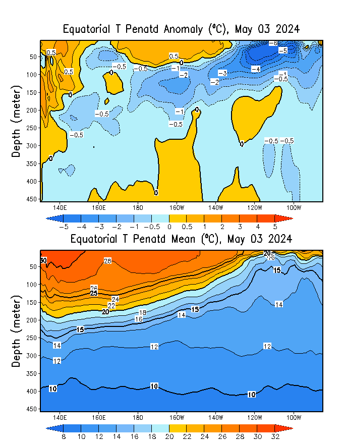
The latest saved loop of the sub-surface waters shows how the large warm pool continues to expand eastward and now moving towards the surface.

Image
0 likes   
Visit the Caribbean-Central America Weather Thread where you can find at first post web cams,radars
and observations from Caribbean basin members Click Here

User avatar
cycloneye
Admin
Admin
Posts: 145303
Age: 68
Joined: Thu Oct 10, 2002 10:54 am
Location: San Juan, Puerto Rico

Re: ENSO Updates

#3476 Postby cycloneye » Mon Mar 03, 2014 1:08 pm

The CPC 3/3/14 update has Nino 3.4 down from -0.4C that was last week to -0.6C this week. I suspect that the effects from the large warm pool will be seen in the next 2 to 3 weeks.

http://www.cpc.ncep.noaa.gov/products/a ... ts-web.pdf

Image
0 likes   
Visit the Caribbean-Central America Weather Thread where you can find at first post web cams,radars
and observations from Caribbean basin members Click Here

User avatar
cycloneye
Admin
Admin
Posts: 145303
Age: 68
Joined: Thu Oct 10, 2002 10:54 am
Location: San Juan, Puerto Rico

Re: ENSO: CPC 3/3/14 has Nino 3.4 at -0.6C

#3477 Postby cycloneye » Mon Mar 03, 2014 6:49 pm

The 30 day SOI continues to go down now at -2.0

20140201,20140302,-2.0
0 likes   
Visit the Caribbean-Central America Weather Thread where you can find at first post web cams,radars
and observations from Caribbean basin members Click Here

stephen23
Category 1
Category 1
Posts: 341
Joined: Sat Aug 04, 2012 10:57 pm
Location: North Fort Worth

Re: ENSO: CPC 3/3/14 has Nino 3.4 at -0.6C

#3478 Postby stephen23 » Mon Mar 03, 2014 8:02 pm

Im confused. Im just trying to learn this whole side of weather. Doesn't the decrease of 3.4 mean that we are trnding back to la nina? Just confused in how all this works.
0 likes   
Personal Forecast Disclaimer:
The posts in this forum are NOT official forecast and should not be used as such. They are just the opinion of the poster and may or may not be backed by sound meteorological data. They are NOT endorsed by any professional institution or storm2k.org. For official information, please refer to the NHC and NWS products.

User avatar
cycloneye
Admin
Admin
Posts: 145303
Age: 68
Joined: Thu Oct 10, 2002 10:54 am
Location: San Juan, Puerto Rico

Re: ENSO: CPC 3/3/14 has Nino 3.4 at -0.6C

#3479 Postby cycloneye » Mon Mar 03, 2014 8:22 pm

stephen23 wrote:Im confused. Im just trying to learn this whole side of weather. Doesn't the decrease of 3.4 mean that we are trnding back to la nina? Just confused in how all this works.


I think our friend Ntxw can explain with more detailed analysis all about how ENSO works but I can tell you that an upwelling phase after a kelvin wave has caused the cooling of Nino 3.4. But the large warm pool that is at the Sub-Surface will warm the waters at surface in the coming weeks.

Image
0 likes   
Visit the Caribbean-Central America Weather Thread where you can find at first post web cams,radars
and observations from Caribbean basin members Click Here

User avatar
Ntxw
Storm2k Moderator
Storm2k Moderator
Posts: 22784
Joined: Wed Oct 21, 2009 6:34 pm
Location: DFW, Texas

Re: ENSO: CPC 3/3/14 has Nino 3.4 at -0.6C

#3480 Postby Ntxw » Mon Mar 03, 2014 8:22 pm

stephen23 wrote:Im confused. Im just trying to learn this whole side of weather. Doesn't the decrease of 3.4 mean that we are trnding back to la nina? Just confused in how all this works.


The immediate surface reflects the cold pool that has been up welling as the warm pool is moving up the thermocline. The rest of it will get pushed up before the warmth arrives. If you look at the loops our friend cycloneye has provided you see how the thermocline works. The warm pool will arrive the second half of March and we will see the beginnings of much more significant warming come April and May as the pool will sustain it for a few months. There is no Nina nor any evidence of one remotely close probably less than 5% chance.

Think of it as a cold front. It's 80F today but there's a massive cold air mass coming doesn't mean it will be 80F tomorrow. You can't stay warm if there is a front approaching even though it is warm on that day. The surface can't stay cold remaining due to the fact there is a mass of warmth ready to surge.
0 likes   
The above post and any post by Ntxw is NOT an official forecast and should not be used as such. It is just the opinion of the poster and may or may not be backed by sound meteorological data. It is NOT endorsed by any professional institution including Storm2k. For official information, please refer to NWS products.


  Help support Storm2K!

Help Support Storm2K


Return to “Talkin' Tropics”

Who is online

Users browsing this forum: Bobbyh83, Google Adsense [Bot], southmdwatcher and 40 guests