
Texas Winter 2013-2014
Moderator: S2k Moderators
Forum rules
 The posts in this forum are NOT official forecast and should not be used as such. They are just the opinion of the poster and may or may not be backed by sound meteorological data. They are NOT endorsed by any professional institution or STORM2K.

The posts in this forum are NOT official forecast and should not be used as such. They are just the opinion of the poster and may or may not be backed by sound meteorological data. They are NOT endorsed by any professional institution or STORM2K.
-
srainhoutx

- S2K Supporter

- Posts: 6919
- Age: 68
- Joined: Sun Jan 14, 2007 11:34 am
- Location: Haywood County, NC
- Contact:
Re: Texas Winter 2013-2014
Water vapor imagery is depicting at least 3 features worth monitoring. The main cold core upper low is moving into Western New Mexico and a secondary disturbance is developing further S near Ruidoso/Cloudcroft. A third disturbance is now approaching the Baja from the Eastern Pacific and all the disturbances are generally moving E to ENE.
0 likes
Carla/Alicia/Jerry(In The Eye)/Michelle/Charley/Ivan/Dennis/Katrina/Rita/Wilma/Ike/Harvey
Member: National Weather Association
Wx Infinity Forums
http://wxinfinity.com/index.php
Facebook.com/WeatherInfinity
Twitter @WeatherInfinity
Member: National Weather Association
Wx Infinity Forums
http://wxinfinity.com/index.php
Facebook.com/WeatherInfinity
Twitter @WeatherInfinity

Man, we are just jinxed on the east side of the metroplex. Tarrant/Denton county getting lit up with thundersleet, we have nothing.
0 likes
The above post and any post by dhweather is NOT an official forecast and should not be used as such. It is just the opinion of the poster and may or may not be backed by sound meteorological data. It is NOT endorsed by any professional institution including storm2k.org. For official information, please refer to NWS products.
Re: Texas Winter 2013-2014
Here in SW Denton we just had a bout of thunder sleet, coming down very hard. It stopped and now it looks like really small/light flurries?
0 likes
-
TheProfessor

- Professional-Met

- Posts: 3506
- Age: 29
- Joined: Tue Dec 03, 2013 10:56 am
- Location: Wichita, Kansas
-
WeatherNewbie
- Tropical Storm

- Posts: 235
- Joined: Mon Mar 22, 2010 3:42 pm
- Location: Richardson, Texas
Sleet just started in Richardson.
0 likes
The above post is NOT an official forecast and should not be used as such. It is just the opinion of the poster and may or may not be backed by sound meteorological data. It is NOT endorsed by any professional institution including storm2k.org. For official information, please refer to NWS products.


Re: Texas Winter 2013-2014
We are getting some weird mixed bag falling right now in the Cedar Hill area. Looks like a sleet/flurry/freezing rain mix. It's hard to tell because the wind is blowing it around.
0 likes
-
srainhoutx
- S2K Supporter
- Posts: 6919
- Age: 68
- Joined: Sun Jan 14, 2007 11:34 am
- Location: Haywood County, NC
- Contact:
Re: Texas Winter 2013-2014
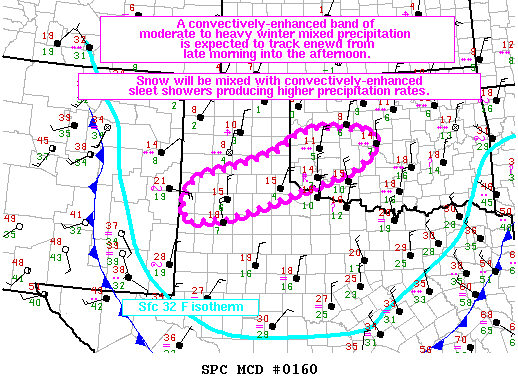
MESOSCALE DISCUSSION 0160
NWS STORM PREDICTION CENTER NORMAN OK
1128 AM CST SUN MAR 02 2014
AREAS AFFECTED...HIGH PLAINS OF WEST TX TO SWRN-CENTRAL OK
CONCERNING...WINTER MIXED PRECIPITATION
VALID 021728Z - 022230Z
SUMMARY...A BAND OF CONVECTIVELY-ENHANCED SLEET/SNOW SHOWERS WITH
EMBEDDED TSTMS IS EXPECTED TO DEVELOP OVER THE HIGH PLAINS OF WEST
TX TOWARD 18Z INTO THE EARLY AFTERNOON WITH ACTIVITY SPREADING ENEWD
INTO SWRN OK THIS AFTERNOON. THE AREA OF GREATEST POTENTIAL FOR
THIS WINTER WEATHER HAZARD IS GENERALLY 35 MILES EITHER SIDE OF A
LINE FROM 35 SE CVS TO 35 WNW OKC. ADDITIONAL ONGOING ELEVATED
TSTMS OVER SWRN OK SHOULD REACH CENTRAL OK /NEAR OKC METRO/ BETWEEN
19-20Z SUPPORTING ENHANCED PRECIPITATION RATES OF SNOW AND SLEET.
DISCUSSION...AN ARCTIC AIR MASS HAS SPREAD SWD ACROSS THE TX HIGH
PLAINS AND MUCH OF OK WITH SURFACE TEMPERATURES ACROSS THE
DISCUSSION AREA CURRENTLY IN THE LOW TO MID TEENS. PRONOUNCED MID
LEVEL COOLING EXPECTED ALONG THE TRACK OF THE ERN NM SHORTWAVE
TROUGH WILL RESULT IN STEEPENING OF 700-500 MB LAPSE RATES WITH NWD
AND NEWD EXTENT INTO WRN/SRN OK. STRONG FORCING FOR ASCENT
SPREADING ACROSS THE HIGH PLAINS OF W TX AND TX PANHANDLE INTO
WRN/CENTRAL OK ATTENDANT TO DPVA WITH THE TROUGH IS EXPECTED TO
RESULT IN AN INCREASE IN ELEVATED CONVECTION. THE LAST SEVERAL RUNS
OF THE HRRR /11-15Z/ SUPPORT THIS SCENARIO WITH CONVECTIVE ELEMENTS
INCREASING IN COVERAGE ACROSS THE WRN HALF OF THE DISCUSSION AREA BY
18-19Z...AND SPREADING ENEWD. A LEADING AREA OF ONGOING/SUSTAINED
TSTM DEVELOPMENT OVER SWRN OK TO INVOF CDS MAY BE AFFECTED NOW BY
INCREASING UVVS WITH THE APPROACHING TROUGH...AND THIS ACTIVITY
SHOULD TRACK ENEWD POTENTIALLY REACHING CENTRAL OK /IN VICINITY AND
JUST WEST OF OKC/ BETWEEN 19-20Z.
..PETERS.. 03/02/2014
ATTN...WFO...OUN...LUB...AMA...
0 likes
Carla/Alicia/Jerry(In The Eye)/Michelle/Charley/Ivan/Dennis/Katrina/Rita/Wilma/Ike/Harvey
Member: National Weather Association
Wx Infinity Forums
http://wxinfinity.com/index.php
Facebook.com/WeatherInfinity
Twitter @WeatherInfinity
Member: National Weather Association
Wx Infinity Forums
http://wxinfinity.com/index.php
Facebook.com/WeatherInfinity
Twitter @WeatherInfinity
-
TrekkerCC

- S2K Supporter
- Posts: 263
- Joined: Sat Sep 06, 2003 10:19 pm
- Location: North Central Texas (Dallas Area)
Re:
Tammie wrote:Lightening reported in Little Elm. Also, another Dentonite just posted on Facebook large hail mised in with thundersleet at her house. Is that truly possible???
I can believe it. Thundersleet is just like a regular thunderstorm other than the precip type is different, if you have rapid updrafts/downdrafts then hail can result just like a thunderstorm in the Spring or Summer.
0 likes
Storm2K Forecast Disclaimer:
This post is NOT AN OFFICIAL FORECAST and should not be used as such. It is just the opinion of the poster and may or may not be backed by sound meteorological data. It is NOT endorsed by any professional institution including storm2k.org. For Official Information please refer to the NHC and NWS products.
This post is NOT AN OFFICIAL FORECAST and should not be used as such. It is just the opinion of the poster and may or may not be backed by sound meteorological data. It is NOT endorsed by any professional institution including storm2k.org. For Official Information please refer to the NHC and NWS products.
-
ColdFusion

- S2K Supporter
- Posts: 452
- Joined: Wed Feb 13, 2008 3:46 pm
- Location: Addison, TX
Re:
TheProfessor wrote:Light snow with near blizzard conditions here. can't wait for the line out near Wichita Falls to develop!
Near blizzard conditions? Are you serious?
0 likes
-
TheProfessor
- Professional-Met
- Posts: 3506
- Age: 29
- Joined: Tue Dec 03, 2013 10:56 am
- Location: Wichita, Kansas
-
Lagreeneyes03
- Category 2

- Posts: 608
- Joined: Mon Dec 09, 2013 10:53 am
- Location: Luxurious Lake Grapevine
Re: Texas Winter 2013-2014
TheProfessor wrote:Lagreeneyes03 wrote:We must be dry slotted here right next to DFW airport-bone dry not a drop or pellet of anything. Not even moisture on the pavement in my part of Grapevine.
Wow im 1 mile south west of lake Grapevine in Southlake and were getting pounded right now
I spoke to soon--THUNDERSLEET!
0 likes
I'm a Princess, not a forecaster.
-
TrekkerCC
- S2K Supporter
- Posts: 263
- Joined: Sat Sep 06, 2003 10:19 pm
- Location: North Central Texas (Dallas Area)
Re:
TheProfessor wrote::uarrow: yeah at times it was very close to white out conditions
Can you confirm it is not sleet (which might look like snow) and it is actually snow falling where you are?
0 likes
Storm2K Forecast Disclaimer:
This post is NOT AN OFFICIAL FORECAST and should not be used as such. It is just the opinion of the poster and may or may not be backed by sound meteorological data. It is NOT endorsed by any professional institution including storm2k.org. For Official Information please refer to the NHC and NWS products.
This post is NOT AN OFFICIAL FORECAST and should not be used as such. It is just the opinion of the poster and may or may not be backed by sound meteorological data. It is NOT endorsed by any professional institution including storm2k.org. For Official Information please refer to the NHC and NWS products.

Re: Texas Winter 2013-2014
Ralph's Weather wrote:ravyrn wrote:Ralph's Weather wrote:If I understand the mountain's role correctly, their effect is felt when the cold is filtering in from the NE. This year many of our cold spells have come from the "Polar Vortex" over the Great Lakes so the cold has had to traverse the mountains. This front is pulling air from the Plains so the mountains should not have an effect on our weather this time.
Your note on the very warm air aloft is valid though and will likely have an effect on the heavier stuff until the deeper cold filters in.
No, their E-W alignment is most noticed when the cold comes from the NW or NNW. If the cold comes from the NE, the damming affect isn't as deep or noticed. The ArkLaTex is SE of the Ouachita mountains.
The mountains are in SE OK which is NE of E TX. The current front is gonna have no issues with the mountains at least as far as the Tyler/Longview are is concerned.

Actually, that'd be north of E TX. I am referring to the ArkLaTex, however, and not E TX. The Oauchitas are NW of the ArkLaTex. As I guessed, the cold air did get dammed up somewhat by the Oauchitas.
0 likes
-
Portastorm

- Storm2k Moderator

- Posts: 9954
- Age: 63
- Joined: Fri Jul 11, 2003 9:16 am
- Location: Round Rock, TX
- Contact:
Re: Texas Winter 2013-2014
OK, I'll admit it now ... I'm terribly jealous of you folks in North Texas. Thundersleet is awesome! Last saw it here in Austin back in February 2003. Enjoy it and if someone can take a video or something, all the better. Pictures too for those of us to your south building cold rain men. 
0 likes
Any forecasts under my name are to be taken with a grain of salt. Get your best forecasts from the National Weather Service and National Hurricane Center.
-
orangeblood
- S2K Supporter
- Posts: 3895
- Joined: Tue Dec 15, 2009 6:14 pm
- Location: Fort Worth, TX
Re: Texas Winter 2013-2014
This is one of the most impressive arctic airmasses I've seen in quite some time and it's March 2nd....now down to 22 F at my house, RAP has DFW flirting awfully close to the all-time March record of 10 F tomorrow morning.
0 likes
-
TheProfessor
- Professional-Met
- Posts: 3506
- Age: 29
- Joined: Tue Dec 03, 2013 10:56 am
- Location: Wichita, Kansas
Re: Re:
TrekkerCC wrote:TheProfessor wrote::uarrow: yeah at times it was very close to white out conditions
Can you confirm it is not sleet (which might look like snow) and it is actually snow falling where you are?
Yeah, I was outside and the precip was soft, there was sleet mixed in with it.
0 likes
An alumnus of The Ohio State University.
Your local National Weather Service office is your best source for weather information.
Your local National Weather Service office is your best source for weather information.
-
South Texas Storms

- Professional-Met
- Posts: 4255
- Joined: Thu Jun 24, 2010 12:28 am
- Location: Houston, TX
Re: Texas Winter 2013-2014
Portastorm wrote:OK, I'll admit it now ... I'm terribly jealous of you folks in North Texas. Thundersleet is awesome! Last saw it here in Austin back in February 2003. Enjoy it and if someone can take a video or something, all the better. Pictures too for those of us to your south building cold rain men.
Ha...my dad in SA wishes he could be building a cold rain man. SA got missed by the rain again as it stayed just to the NE. This is getting downright depressing. Less than 1 inch so far for the year. We really need El Nino to bring us some rain.
0 likes
-
TrekkerCC
- S2K Supporter
- Posts: 263
- Joined: Sat Sep 06, 2003 10:19 pm
- Location: North Central Texas (Dallas Area)
Re: Re:
TheProfessor wrote:TrekkerCC wrote:TheProfessor wrote::uarrow: yeah at times it was very close to white out conditions
Can you confirm it is not sleet (which might look like snow) and it is actually snow falling where you are?
Yeah, I was outside and the precip was soft, there was sleet mixed in with it.
Very Cool! I wonder what will happen once the main batch forms out to the west.
BTW - for everyone's information the thunderstorm dropping sleet has tops of 34,000ft+ (this is the storm that is hitting Carrollton).
0 likes
Storm2K Forecast Disclaimer:
This post is NOT AN OFFICIAL FORECAST and should not be used as such. It is just the opinion of the poster and may or may not be backed by sound meteorological data. It is NOT endorsed by any professional institution including storm2k.org. For Official Information please refer to the NHC and NWS products.
This post is NOT AN OFFICIAL FORECAST and should not be used as such. It is just the opinion of the poster and may or may not be backed by sound meteorological data. It is NOT endorsed by any professional institution including storm2k.org. For Official Information please refer to the NHC and NWS products.
-
orangeblood
- S2K Supporter
- Posts: 3895
- Joined: Tue Dec 15, 2009 6:14 pm
- Location: Fort Worth, TX
Re: Texas Winter 2013-2014
Check out the storms beginning to bust through the CAP south of Wichita Falls, exactly what the RAP has been depicting....
0 likes
Who is online
Users browsing this forum: ElectricStorm, KirbyDude25, SnowyOwl31 and 58 guests