ENSO Updates (2007 thru 2023)
Moderator: S2k Moderators
Forum rules

The posts in this forum are NOT official forecasts and should not be used as such. They are just the opinion of the poster and may or may not be backed by sound meteorological data. They are NOT endorsed by any professional institution or STORM2K. For official information, please refer to products from the National Hurricane Center and National Weather Service.
-
Kingarabian

- S2K Supporter

- Posts: 16364
- Joined: Sat Aug 08, 2009 3:06 am
- Location: Honolulu, Hawaii

Re: ENSO: CPC 3/3/14 has Nino 3.4 at -0.6C
Ok so if we do go el nino then we should have less hurricanes this year unless we have a crazy year like 2004 right? Or does a week nino really not play a factor that much?
0 likes
Personal Forecast Disclaimer:
The posts in this forum are NOT official forecast and should not be used as such. They are just the opinion of the poster and may or may not be backed by sound meteorological data. They are NOT endorsed by any professional institution or storm2k.org. For official information, please refer to the NHC and NWS products.
The posts in this forum are NOT official forecast and should not be used as such. They are just the opinion of the poster and may or may not be backed by sound meteorological data. They are NOT endorsed by any professional institution or storm2k.org. For official information, please refer to the NHC and NWS products.


Re: ENSO: CPC 3/3/14 has Nino 3.4 at -0.6C
stephen23 wrote:Ok so if we do go el nino then we should have less hurricanes this year unless we have a crazy year like 2004 right? Or does a week nino really not play a factor that much?
Hard to say at this time. It's a known fact that moderate and strong Nino's feature below normal ACE in the Atlantic and the stronger ones are often the quietest of the bunch. Weaker Nino's tend not to influence as much shear into the Atlantic as their counterparts then more is dependent on local conditions of the basin, this is common sense when thinking about it.
This says nothing about landfalls and any individual system only what the season as a whole might turn out to be. In other words first we need to get a Nino<- we know the odds of this is slowly creeping up, and then we need to determine how strong it will be to know what effects it may or may not have on the Atlantic season which at this time the skill for predicting is no more than an educated guess. Maybe in May or June we will have better evidence of how ENSO and the hurricane season will play out.
0 likes
The above post and any post by Ntxw is NOT an official forecast and should not be used as such. It is just the opinion of the poster and may or may not be backed by sound meteorological data. It is NOT endorsed by any professional institution including Storm2k. For official information, please refer to NWS products.
Help support Storm2K!
-
cycloneye

- Admin

- Posts: 149464
- Age: 69
- Joined: Thu Oct 10, 2002 10:54 am
- Location: San Juan, Puerto Rico
Re: ENSO Updates
Dr Michael Ventrice lays out an interesting comparison between 1997 and 2014 at this time of year.
WSI Energy Weather @WSI_Energy · 7 min
The current pattern over the West Pac looks eerily similar to the Spring that preceded the "Super El Nino" in 1997.

WSI Energy Weather @WSI_Energy · 7 min
The current pattern over the West Pac looks eerily similar to the Spring that preceded the "Super El Nino" in 1997.
0 likes
Visit the Caribbean-Central America Weather Thread where you can find at first post web cams,radars
and observations from Caribbean basin members Click Here
and observations from Caribbean basin members Click Here
-
hurricanetrack

- HurricaneTrack.com

- Posts: 1781
- Joined: Tue Dec 02, 2003 10:46 pm
- Location: Wilmington, NC
- Contact:
Keep your eyes on the tropical central and wpac. If we see typhoons (especially strong ones) between now and the end of April it's a very good signal for ENSO to spike.
MJO continues to mean business and loops around the Pacific
Westerlies (reds and oranges) started in the far WPAC between 0 and 60E since early Feb and has slowly made it's way east now towards the international dateline and eventually the eastern basin

MJO continues to mean business and loops around the Pacific
Westerlies (reds and oranges) started in the far WPAC between 0 and 60E since early Feb and has slowly made it's way east now towards the international dateline and eventually the eastern basin
0 likes
The above post and any post by Ntxw is NOT an official forecast and should not be used as such. It is just the opinion of the poster and may or may not be backed by sound meteorological data. It is NOT endorsed by any professional institution including Storm2k. For official information, please refer to NWS products.
Help support Storm2K!
Help support Storm2K!
The longpaddock (daily) site has the 30 day SOI at -4. We will lose the last of the big +SOI tomorrow and it looks like -SOI will continue on the daily's. Could be another big jump, wouldn't be surprised if we were at -6 or lower the next week or two.

0 likes
The above post and any post by Ntxw is NOT an official forecast and should not be used as such. It is just the opinion of the poster and may or may not be backed by sound meteorological data. It is NOT endorsed by any professional institution including Storm2k. For official information, please refer to NWS products.
Help support Storm2K!
Help support Storm2K!
-
xtyphooncyclonex

- Category 5
- Posts: 3891
- Age: 24
- Joined: Sat Dec 08, 2012 9:07 am
- Location: Cebu City
- Contact:
Faxai now officially a typhoon. Could this be related to ENSO?
0 likes
REMINDER: My opinions that I, or any other NON Pro-Met in this forum, are unofficial. Please do not take my opinions as an official forecast and warning. I am NOT a meteorologist. Following my forecasts blindly may lead to false alarm, danger and risk if official forecasts from agencies are ignored.
-
cycloneye
- Admin
- Posts: 149464
- Age: 69
- Joined: Thu Oct 10, 2002 10:54 am
- Location: San Juan, Puerto Rico
Re: ENSO Updates
The latest 30 day SOI reading is down to -3.4.
20140202,20140303,-3.4
20140202,20140303,-3.4
0 likes
Visit the Caribbean-Central America Weather Thread where you can find at first post web cams,radars
and observations from Caribbean basin members Click Here
and observations from Caribbean basin members Click Here
Re:
xtyphooncyclonex wrote:Faxai now officially a typhoon. Could this be related to ENSO?
Yes, adds on more westerlies. Feedback is likely occuring.
0 likes
The above post and any post by Ntxw is NOT an official forecast and should not be used as such. It is just the opinion of the poster and may or may not be backed by sound meteorological data. It is NOT endorsed by any professional institution including Storm2k. For official information, please refer to NWS products.
Help support Storm2K!
Help support Storm2K!

-
cycloneye
- Admin
- Posts: 149464
- Age: 69
- Joined: Thu Oct 10, 2002 10:54 am
- Location: San Juan, Puerto Rico
Re: ENSO Updates
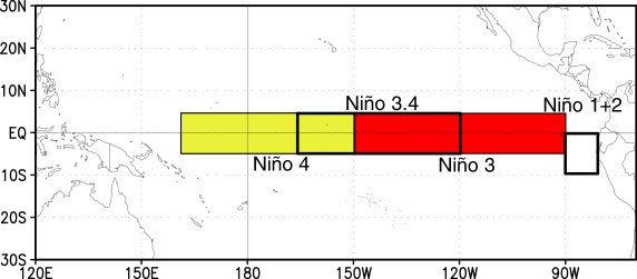
For the newbies and others who may not know where are the four ENSO regions located,here is a good graphic.
0 likes
Visit the Caribbean-Central America Weather Thread where you can find at first post web cams,radars
and observations from Caribbean basin members Click Here
and observations from Caribbean basin members Click Here
-
xtyphooncyclonex
- Category 5
- Posts: 3891
- Age: 24
- Joined: Sat Dec 08, 2012 9:07 am
- Location: Cebu City
- Contact:
Forest fires prevailing over Malaysia's capital, Kuala Lumpur. Several fires sprouting over SE Asia; First Philippines, then this. I know that the effects of the ENSO are felt later but, this time early is weird!
0 likes
REMINDER: My opinions that I, or any other NON Pro-Met in this forum, are unofficial. Please do not take my opinions as an official forecast and warning. I am NOT a meteorologist. Following my forecasts blindly may lead to false alarm, danger and risk if official forecasts from agencies are ignored.
-
euro6208
Re: ENSO Updates
Ntxw...
What would you expect this year for the Western Pacific if weak or Super el nino?
What would you expect this year for the Western Pacific if weak or Super el nino?
0 likes
-
xtyphooncyclonex
- Category 5
- Posts: 3891
- Age: 24
- Joined: Sat Dec 08, 2012 9:07 am
- Location: Cebu City
- Contact:
Re: ENSO Updates
cycloneye wrote:Dr Michael Ventrice lays out an interesting comparison between 1997 and 2014 at this time of year.
WSI Energy Weather @WSI_Energy · 7 min
The current pattern over the West Pac looks eerily similar to the Spring that preceded the "Super El Nino" in 1997.
GFS is even developing another one lashing the PHL!
0 likes
REMINDER: My opinions that I, or any other NON Pro-Met in this forum, are unofficial. Please do not take my opinions as an official forecast and warning. I am NOT a meteorologist. Following my forecasts blindly may lead to false alarm, danger and risk if official forecasts from agencies are ignored.
Re: ENSO Updates
euro6208 wrote:Ntxw...
What would you expect this year for the Western Pacific if weak or Super el nino?
Higher risk of an above normal season and higher risk of typhoons becoming STYs. A stronger Nino will likely start the season faster and harder straight through the year if it occurs. What I'm starting to wonder is if the big ending to last season in the wpac was an indicator westerlies would come several weeks later.
SOI continues downward and with tropical cyclones around it's not likely to rise anytime soon.
0 likes
The above post and any post by Ntxw is NOT an official forecast and should not be used as such. It is just the opinion of the poster and may or may not be backed by sound meteorological data. It is NOT endorsed by any professional institution including Storm2k. For official information, please refer to NWS products.
Help support Storm2K!
Help support Storm2K!
-
Andrew92

- S2K Supporter
- Posts: 3247
- Age: 42
- Joined: Mon Jun 16, 2003 12:35 am
- Location: Phoenix, Arizona
Re: ENSO Updates
Ntxw wrote:euro6208 wrote:Ntxw...
What would you expect this year for the Western Pacific if weak or Super el nino?
Higher risk of an above normal season and higher risk of typhoons becoming STYs. A stronger Nino will likely start the season faster and harder straight through the year if it occurs. What I'm starting to wonder is if the big ending to last season in the wpac was an indicator westerlies would come several weeks later.
SOI continues downward and with tropical cyclones around it's not likely to rise anytime soon.
The following post is NOT an official forecast and should not be used as such. It is just the opinion of the poster and may or may not be backed by sound meteorological data. It is NOT endorsed by any professional institution or storm2k.org. For official information, please refer to the NHC and NWS products.
I must admit to not know much about the Western Pacific, the frequency of tropical storms and typhoons there, and their relation to El Nino. However, some initial research looking at 1981-82 and 1996-97 does indeed yield some similarities to what is happening this year over there. There were super typhoons in November of 1981 and 1996, to go along with Haiyan this past November. Late March of 1982 was a pretty busy time over there too, especially for the Philippines as two storms, including a typhoon, directly hit those islands, while another fish storm meandered for a few days, sort of like Faxai right now. Although no storms reached the Philippines in early 1997, the remnants of one that occurred in January did, and then in April came another fish tropical storm that lasted about a week. I also haven't mentioned Kajiki, which did also impact the Philippines as a minimal tropical storm at the end of January/beginning of February of this year. A couple weeks before that was Lingling, a similarly weak storm that meandered just east of the Philippines.
I don't think this entirely means anything, as like I said, my knowledge in this area is quite limited. But it is compelling nonetheless, and hints at the strong possibility of a very strong El Nino this year. Couple that with the graphic of April 1997 versus today, and my eyebrows are raised.
-Andrew92
0 likes
-
cycloneye
- Admin
- Posts: 149464
- Age: 69
- Joined: Thu Oct 10, 2002 10:54 am
- Location: San Juan, Puerto Rico
Re: ENSO Updates
Some things to point out from the sst anomalies graphics below about ENSO are the following:
1-Waters in WestCentral Pacific are very warm.
2-Waters off Baja/Coast of California are warm.
3-Waters off Central America are warm.
4-Indian Ocean is cold.
5-Waters just off equatorial South America are beginning to warm.
6-The PDO looks to stay in positive on next update with less cold waters between Hawaii and California.
7-The Sub-Surface waters are very warm with the large pool about to reach the surface.
8-30 day SOI is in negative.
9-ESPI is positive.
All of the above are ingredients that are signs of an impending El Nino coming. How strong it may be is the big question.
0 likes
Visit the Caribbean-Central America Weather Thread where you can find at first post web cams,radars
and observations from Caribbean basin members Click Here
and observations from Caribbean basin members Click Here
-
Kingarabian
- S2K Supporter
- Posts: 16364
- Joined: Sat Aug 08, 2009 3:06 am
- Location: Honolulu, Hawaii
-
cycloneye
- Admin
- Posts: 149464
- Age: 69
- Joined: Thu Oct 10, 2002 10:54 am
- Location: San Juan, Puerto Rico
Re: ENSO Updates
30 day SOI down to -3.8.
20140203,20140304,-3.8
20140203,20140304,-3.8
0 likes
Visit the Caribbean-Central America Weather Thread where you can find at first post web cams,radars
and observations from Caribbean basin members Click Here
and observations from Caribbean basin members Click Here
Who is online
Users browsing this forum: No registered users and 77 guests