
ENSO Updates (2007 thru 2023)
Moderator: S2k Moderators
Forum rules

The posts in this forum are NOT official forecasts and should not be used as such. They are just the opinion of the poster and may or may not be backed by sound meteorological data. They are NOT endorsed by any professional institution or STORM2K. For official information, please refer to products from the National Hurricane Center and National Weather Service.
-
cycloneye

- Admin

- Posts: 149463
- Age: 69
- Joined: Thu Oct 10, 2002 10:54 am
- Location: San Juan, Puerto Rico
Re: ENSO: PDO Febuary update is up to +38
Will ECMWF be right this time as we know what happened in 2013 with their forecasts?
0 likes
Visit the Caribbean-Central America Weather Thread where you can find at first post web cams,radars
and observations from Caribbean basin members Click Here
and observations from Caribbean basin members Click Here

Re: Atlantic Sea Surface Temperatures and Anomalies
wxman57 wrote:2004 was El Nino, not warm neutral. JJA average anomaly -.5C. By July-Sept the 3-month average was -.7C. It's a good analog for what we're seeing this year, considering the predictions of El Nino. Not that we're expecting 4 major hurricane impacts in Florida in 2014. In 2003-2004, the Dec-Feb average was +.3C vs. -.7C for 2013-2014. SSTs in Nino 3.4 are 1C cooler than the start of 2004.
http://www.cpc.ncep.noaa.gov/products/analysis_monitoring/ensostuff/ensoyears.shtml
Thank you Waxman57. That was what I was trying to ask. I was thinking 2003 was neutral and 2004 was +PDO El Nino during hurricane season. Looking back since 1990....... In +PDO years when were were in neutral years
1990 14-8-1
Post-Modoki 1992 7-4-1 1 landfall hurricane gulf coast
1993 8-4-1
1996 13-9-6
Post Modoki 2003 16-7-3 1 landfall hurricane gulf coast
Post Modoki 2005 28-5-7 5 landfall hurricane gulf coast
it appears there has been a landfall hurricane on gulf coast 0% of the time in a normal ENSO neutral +PDO year and had been a landfall Gulf Coast hurricane 100% of the time in a post-Modoki Enso neutral +PDO year.
On the other hand since 1990 there has been a gulf coast landfall hurricane 80% of the time during El Nino +PDO years and there has been a El Nino Modoki 60% of the times we have been in El Nino +PDO
Modoki 1991 8-4-2
1997 8-3-1 1 landfall hurricane gulf coast
Modoki 2002 12-4-2 1 landfall hurricane gulf coast
Modoki 2004 15-9-6 2 landfall hurricane gulf coast
2009 9-3-2 1 landfall hurricane gulf coast
Could there be anything to this in your expertise? Also all neutral and el Nino states were only looked at during the actual state during hurricane season.
0 likes
Personal Forecast Disclaimer:
The posts in this forum are NOT official forecast and should not be used as such. They are just the opinion of the poster and may or may not be backed by sound meteorological data. They are NOT endorsed by any professional institution or storm2k.org. For official information, please refer to the NHC and NWS products.
The posts in this forum are NOT official forecast and should not be used as such. They are just the opinion of the poster and may or may not be backed by sound meteorological data. They are NOT endorsed by any professional institution or storm2k.org. For official information, please refer to the NHC and NWS products.
-
cycloneye
- Admin
- Posts: 149463
- Age: 69
- Joined: Thu Oct 10, 2002 10:54 am
- Location: San Juan, Puerto Rico
Re: ENSO: PDO Febuary update is up to +38
The latest 30 day SOI update has it down to -7.2.
20140210,20140311,-7.2
http://www.bom.gov.au/climate/enso/soi.txt
20140210,20140311,-7.2
http://www.bom.gov.au/climate/enso/soi.txt
0 likes
Visit the Caribbean-Central America Weather Thread where you can find at first post web cams,radars
and observations from Caribbean basin members Click Here
and observations from Caribbean basin members Click Here

Re: ENSO: PDO Febuary update is at +38
cycloneye wrote:PDO Febuary update is up to +38
The Febuary update is up from the +30 of January.
http://jisao.washington.edu/pdo/PDO.latest
We haven't seen a +PDO reading since the 2009/10 El Nino, nonetheless back to back positive readings! March looks even better thus far (through 12 days) with the classic warm horseshoe eastern Pacific, cold thumb western Pacific. May see another positive reading come April.
0 likes
The above post and any post by Ntxw is NOT an official forecast and should not be used as such. It is just the opinion of the poster and may or may not be backed by sound meteorological data. It is NOT endorsed by any professional institution including Storm2k. For official information, please refer to NWS products.
Help support Storm2K!

Re: Atlantic Sea Surface Temperatures and Anomalies
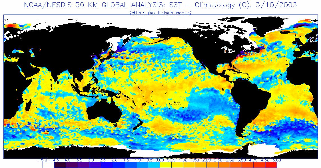
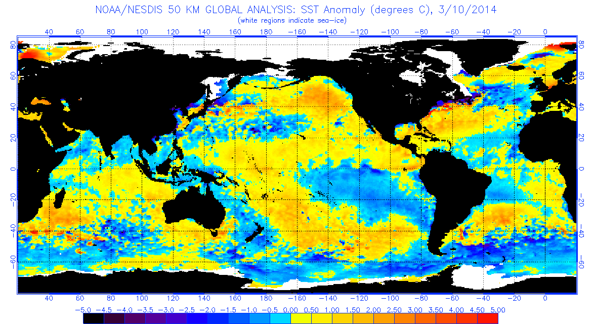
stephen23 wrote:blp wrote:2003 has some similarities
http://www.ospo.noaa.gov/data/sst/anoma ... 0.2003.gif
http://www.ospo.noaa.gov/data/sst/anoma ... 0.2014.gif
Wasn't 2003 also a neutral year that was transitioning to el nino in 2004?
Winter ENSO
2002-2003 Moderate Modoki El Nino
2003-2004 Neutral
2004-2005 Weak Modoki El Nino
2005-2006 Weak La Nina
2006-2007 Weak Eastern Equatorial El Nino
2007-2008 Strong La Nina
2008-2009 Weak La Nina
2009-2010 Strong Modoki El Nino
2010-2011 Strong La Nina
2011-2012 Weak La Nina
2012-2013 Neutral
2013-2014 Neutral
0 likes
Re: ENSO: PDO Febuary update is at +38
Ntxw wrote:cycloneye wrote:PDO Febuary update is up to +38
The Febuary update is up from the +30 of January.
http://jisao.washington.edu/pdo/PDO.latest
We haven't seen a +PDO reading since the 2009/10 El Nino, nonetheless back to back positive readings! March looks even better thus far (through 12 days) with the classic warm horseshoe eastern Pacific, cold thumb western Pacific. May see another positive reading come April.
PDO Phase
1924-1947 Warm PDO
1947-1977 Cool PDO
1977-1998 Warm PDO
1998-2002 Cool PDO
2002-2007 Warm PDO
2007-? Cool PDO
0 likes
Well if we're going to use ENSO has a model, lets throw the early 90s in there.
1991-1992-Moderate Modoki El Nino
1992-1993-Neutral
1993-1994-Neutral <-Freak low ACE neutral year much like last year
1994-1995-Moderate Modoki El Nino
Wouldn't you say those two neutrals then Nino would fit better? Strange when you look deep into it, it seems Modoki El Nino's are the majority of Nino's not minority 2004 isn't so special after all just that it was one of the weakest in the bunch.
0 likes
The above post and any post by Ntxw is NOT an official forecast and should not be used as such. It is just the opinion of the poster and may or may not be backed by sound meteorological data. It is NOT endorsed by any professional institution including Storm2k. For official information, please refer to NWS products.
Help support Storm2K!
Help support Storm2K!
Re: Atlantic Sea Surface Temperatures and Anomalies
Ntxw wrote:Well if we're going to use ENSO has a model, lets throw the early 90s in there.
1991-1992-Moderate Modoki El Nino
1992-1993-Neutral
1993-1994-Neutral <-Freak low ACE neutral year much like last year
1994-1995-Moderate Modoki El Nino
Wouldn't you say those two neutrals then Nino would fit better? Strange when you look deep into it, it seems Modoki El Nino's are the majority of Nino's not minority 2004 isn't so special after all just that it was one of the weakest in the bunch.
All the years you listed were already accounted for in my post above. I have looked back every year to 1950 with the Enso phase and PDO phase and have found no pattern in ENSO phases. For instance, from the years between 1990 and present at hurricane season there has been 10 neutral years, 7 El Nino years, and 7 La Nina years in no kind of pattern. N,El,N,N,El,La,N,El,La,La,La,N,El,N,El,N,El,La,N,El,La,La,N,N
0 likes
Personal Forecast Disclaimer:
The posts in this forum are NOT official forecast and should not be used as such. They are just the opinion of the poster and may or may not be backed by sound meteorological data. They are NOT endorsed by any professional institution or storm2k.org. For official information, please refer to the NHC and NWS products.
The posts in this forum are NOT official forecast and should not be used as such. They are just the opinion of the poster and may or may not be backed by sound meteorological data. They are NOT endorsed by any professional institution or storm2k.org. For official information, please refer to the NHC and NWS products.

Re: Re:
ninel conde wrote:ninel conde wrote:i think its past pathetic at this time. not sure it could be any more stable. im not sure it even matters if there is an el nino or not will all other factors so negative.
http://www.ssd.noaa.gov/PS/TROP/TCFP/da ... t_THDV.gif
I was just going to ask to post some of the products showing this "basement" factor of stable air over the Atlantic. Getting more ridiculous by the quarter indeed.
0 likes

Re:
RL3AO wrote:There has been so much Arctic flow into the Eastern US/Atlantic that I can't imagine the current stability being a guaranteed sign in Summer/Fall. In fact, you can already see it rebounding towards normal as the pattern shifts to Spring.
A lot of this depends on moisture. In the mid latitudes (subtropics) it's definitely the relationship and balance between warm and cold air. In the tropics it's a little different I suspect since true cold air doesn't make it that far south in the warm months, or really any month. There it relies on moisture (instability is the relationship between temperature and moisture so here it relies on the second part more) and when the tropics is dry, it's likely stable and if it's wet it's likely unstable.
Back on topic, we should be watching the Pacific typhoon basins WPAC and CPAC as it may signal the next westerly burst out west.
0 likes
The above post and any post by Ntxw is NOT an official forecast and should not be used as such. It is just the opinion of the poster and may or may not be backed by sound meteorological data. It is NOT endorsed by any professional institution including Storm2k. For official information, please refer to NWS products.
Help support Storm2K!
Help support Storm2K!
-
cycloneye
- Admin
- Posts: 149463
- Age: 69
- Joined: Thu Oct 10, 2002 10:54 am
- Location: San Juan, Puerto Rico
Re: ENSO: PDO Febuary update is up to +38
CFSv2 aligns with ECMWF on a weak to moderate El Nino for ASO. But is the so called spring barrier for the models so they have to be looked with caution in this period.

0 likes
Visit the Caribbean-Central America Weather Thread where you can find at first post web cams,radars
and observations from Caribbean basin members Click Here
and observations from Caribbean basin members Click Here
Re: ENSO: PDO Febuary update is up to +38
Cyclenall wrote:ninel conde wrote:ninel conde wrote:i think its past pathetic at this time. not sure it could be any more stable. im not sure it even matters if there is an el nino or not will all other factors so negative.
http://www.ssd.noaa.gov/PS/TROP/TCFP/da ... t_THDV.gif
I was just going to ask to post some of the products showing this "basement" factor of stable air over the Atlantic. Getting more ridiculous by the quarter indeed.
I'm not sure where I see mid March Tropical Atlantic below average instability having an negative affect during hurricane season. Some of the biggest years we remember all had very low below average vertical instability in mid March.
2004 15-9-6
2005 28-15-17
2007 15-6-2
2008 16-8-5
In fact all these years had below average tropical Atlantic vertical instability and Above average GOM instability just as we have in March in 2014.
2013 was a year that had above average Vertical Instability in tropical Atlantic and below average Vertical Instability in GOM during mid March and we all know how that turned out
0 likes
Personal Forecast Disclaimer:
The posts in this forum are NOT official forecast and should not be used as such. They are just the opinion of the poster and may or may not be backed by sound meteorological data. They are NOT endorsed by any professional institution or storm2k.org. For official information, please refer to the NHC and NWS products.
The posts in this forum are NOT official forecast and should not be used as such. They are just the opinion of the poster and may or may not be backed by sound meteorological data. They are NOT endorsed by any professional institution or storm2k.org. For official information, please refer to the NHC and NWS products.
Re: ENSO: PDO Febuary update is up to +38
stephen23 wrote:In fact all these years had below average tropical Atlantic vertical instability and Above average GOM instability just as we have in March in 2014.
2013 was a year that had above average Vertical Instability in tropical Atlantic and below average Vertical Instability in GOM during mid March and we all know how that turned out
But a month of vertical instability (or lack of) doesn't tell the whole story. This is a multi-year problem during Hurricane season. What signal this year points to something different than what has been persistent for quite some time is the question.
0 likes
The above post and any post by Ntxw is NOT an official forecast and should not be used as such. It is just the opinion of the poster and may or may not be backed by sound meteorological data. It is NOT endorsed by any professional institution including Storm2k. For official information, please refer to NWS products.
Help support Storm2K!
Help support Storm2K!
-
cycloneye
- Admin
- Posts: 149463
- Age: 69
- Joined: Thu Oct 10, 2002 10:54 am
- Location: San Juan, Puerto Rico
Re: ENSO: PDO Febuary update is up to +38
Here is a good graphic that shows how the currents are warming in the equatorial Pacific. Graphic was posted on Twitter by NHC forecaster Eric Blake.
Eric Blake @EricBlake12 · 30 min
The equatorial Pacific is surging (well for the ocean) eastward toward South America

http://www.oscar.noaa.gov/datadisplay/o ... pe=nonjava
Eric Blake @EricBlake12 · 30 min
The equatorial Pacific is surging (well for the ocean) eastward toward South America
http://www.oscar.noaa.gov/datadisplay/o ... pe=nonjava
0 likes
Visit the Caribbean-Central America Weather Thread where you can find at first post web cams,radars
and observations from Caribbean basin members Click Here
and observations from Caribbean basin members Click Here
Re: Atlantic Sea Surface Temperatures and Anomalies
Ntxw wrote:Well if we're going to use ENSO has a model, lets throw the early 90s in there.
1991-1992-Moderate Modoki El Nino
1992-1993-Neutral
1993-1994-Neutral <-Freak low ACE neutral year much like last year
1994-1995-Moderate Modoki El Nino
Wouldn't you say those two neutrals then Nino would fit better? Strange when you look deep into it, it seems Modoki El Nino's are the majority of Nino's not minority 2004 isn't so special after all just that it was one of the weakest in the bunch.
A checked back a little further. Actually all the way back to 1950 and the statistics stay the same. Between 1950 and 1990 80% of all El Nino PDO+ years have had a landfall hurricane on gulf coast. Between 1990 and present 80% of all El Nino PDO+ years have had a landfall hurricane on Gulf Coast. The total number of named storms in these years are well below normal except for 1953, 2002, 2004 but it also appears that during these events that the threat of Gulf Coast landfalls may be higher. Out of the 15 years since 1950 that have been El Nino PDO+ only 1976,1982, and 1991 did not have a Gulf Coast Landfall Hurricane. From 1950 to 1990 during El Nino PDO+ years it has turned out to be El Nino Modoki 50% of the time. From 1990 to present during El Nino PDO+ events it has been El Nino Modoki 80% of the time. From 1950 to present during El Nino Modoki years there has been a Gulf Coast landfall hurricane 88.89% of the time with the only exception since 1950 being 1991.
0 likes
Personal Forecast Disclaimer:
The posts in this forum are NOT official forecast and should not be used as such. They are just the opinion of the poster and may or may not be backed by sound meteorological data. They are NOT endorsed by any professional institution or storm2k.org. For official information, please refer to the NHC and NWS products.
The posts in this forum are NOT official forecast and should not be used as such. They are just the opinion of the poster and may or may not be backed by sound meteorological data. They are NOT endorsed by any professional institution or storm2k.org. For official information, please refer to the NHC and NWS products.
-
cycloneye
- Admin
- Posts: 149463
- Age: 69
- Joined: Thu Oct 10, 2002 10:54 am
- Location: San Juan, Puerto Rico
Re: ENSO: PDO Febuary update is up to +38
These graphics speak for themselves about what is going in the sub-surface of the Equatorial Pacific.


0 likes
Visit the Caribbean-Central America Weather Thread where you can find at first post web cams,radars
and observations from Caribbean basin members Click Here
and observations from Caribbean basin members Click Here
-
Portastorm

- Storm2k Moderator

- Posts: 9955
- Age: 63
- Joined: Fri Jul 11, 2003 9:16 am
- Location: Round Rock, TX
- Contact:
Re: Atlantic Sea Surface Temperatures and Anomalies
Eye opening research to be certain, stephen23. Nice work, although the results are concerning.
0 likes
Any forecasts under my name are to be taken with a grain of salt. Get your best forecasts from the National Weather Service and National Hurricane Center.
Re: ENSO: Large warm pool at sub-surface inching to surface

On the rise again
0 likes
Personal Forecast Disclaimer:
The posts in this forum are NOT official forecast and should not be used as such. They are just the opinion of the poster and may or may not be backed by sound meteorological data. They are NOT endorsed by any professional institution or storm2k.org. For official information, please refer to the NHC and NWS products.
The posts in this forum are NOT official forecast and should not be used as such. They are just the opinion of the poster and may or may not be backed by sound meteorological data. They are NOT endorsed by any professional institution or storm2k.org. For official information, please refer to the NHC and NWS products.
-
hurricanetrack

- HurricaneTrack.com

- Posts: 1781
- Joined: Tue Dec 02, 2003 10:46 pm
- Location: Wilmington, NC
- Contact:
I think it is interesting to see two things here:
1. a cold pool has developed in the west Pac instead of more warm anomalies.
2. Fairly nice cold pool holding strong on eastern side of Pacific, right off of South America.
Seems to fit nicely with idea of weak El Nino conditions by the fall - probably centered in C Pacific. Does not seem to be any solid evidence of this so-called "Super El Nino".
0 likes
Who is online
Users browsing this forum: No registered users and 86 guests