When was the last time we had a +PDO?
May 2010
Moderator: S2k Moderators


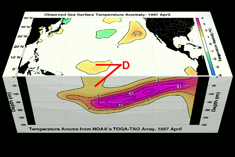
cycloneye wrote:Here is the updated data of the sub-surface. The graphics speak for themselves.


NOAA ENSO data updated already. ESPI is at 0.71, was 0.72 yesterday. Been ~0.70 a few days now. More of a step pause than step fall & step up again. SOI is rapidly moving as well. Average for last 30 days is -12.9. There is alot of anomalous west winds on TAO as of yesterday data. Kelvin waves are tough to model. They are almost always less in the forecast than what occurs. With another one setting up west of there & the general pattern.. once you have them coming regularly & as strong as the one is now, the chances of atleast a weaker one in the wake is good. The temperature anomaly below the surface is higher than before the 1997-98 El Nino event. The circulation of cooler surface water being whisked in from the Southern Pacific, up along South America has been cut off.
Looking at everything. I'm going to be a bit less conservative than NOAA & say 85% of El Nino conditions occurring in the next 7-12weeks. 70% chance this gets declared an offical EL Nino (that persists for 5 months) & 40% chance it becomes a Super El Niño.


Alyono wrote:given the possibility of such strong warming in the CPAC, could this significantly increase the chance of a Hawaiian landfall? Had a strike on the minor unpopulated islands in 2009

cycloneye wrote:I found this post at Dr Masters blog very informative that I am posting it here.NOAA ENSO data updated already. ESPI is at 0.71, was 0.72 yesterday. Been ~0.70 a few days now. More of a step pause than step fall & step up again. SOI is rapidly moving as well. Average for last 30 days is -12.9. There is alot of anomalous west winds on TAO as of yesterday data. Kelvin waves are tough to model. They are almost always less in the forecast than what occurs. With another one setting up west of there & the general pattern.. once you have them coming regularly & as strong as the one is now, the chances of atleast a weaker one in the wake is good. The temperature anomaly below the surface is higher than before the 1997-98 El Nino event. The circulation of cooler surface water being whisked in from the Southern Pacific, up along South America has been cut off.
Looking at everything. I'm going to be a bit less conservative than NOAA & say 85% of El Nino conditions occurring in the next 7-12weeks. 70% chance this gets declared an offical EL Nino (that persists for 5 months) & 40% chance it becomes a Super El Niño.
This post is NOT AN OFFICIAL FORECAST and should not be used as such. It is just the opinion of the poster and may or may not be backed by sound meteorological data. It is NOT endorsed by any professional institution including storm2k.org. For Official Information please refer to the NHC and NWS products.
Kingarabian wrote:For the first time in 2 months, Nino 3.4 is finally creeping into positive territory once again after crossing into 0.0C.
http://img811.imageshack.us/img811/6286/hksc.png

cycloneye wrote:Ntxw, now we are talking the best comparison possible of the warm pool at sub-surface with the past initial stages of El Nino events and 2014.March 2014 warm pool beats every past one.
Yellow Evan wrote:Could we see 3-4C waters reach the surface?
What's the ceiling of this El Nino?

Users browsing this forum: No registered users and 64 guests


