ENSO Updates (2007 thru 2023)

This is the general tropical discussion area. Anyone can take their shot at predicting a storms path.

Moderator: S2k Moderators

Forum rules

The posts in this forum are NOT official forecasts and should not be used as such. They are just the opinion of the poster and may or may not be backed by sound meteorological data. They are NOT endorsed by any professional institution or STORM2K. For official information, please refer to products from the National Hurricane Center and National Weather Service.

Help Support Storm2K
Message
Author
User avatar
Kingarabian
S2K Supporter
S2K Supporter
Posts: 15981
Joined: Sat Aug 08, 2009 3:06 am
Location: Honolulu, Hawaii

Re: I wanted a La Nina

#3801 Postby Kingarabian » Mon Mar 24, 2014 6:37 pm

Cyclenall wrote:At +0.1ºC? Ugh! Kiss the 2014 Atlantic Hurricane season goodbye, the interest in that basin will be at an all time low similar to the early 1980s. Now that the beans have been spilled on Andrew, there is no more "It only takes one" lol. Sure it'll be awesome to see April storms in the Epac (this is tongue in cheek) but still...

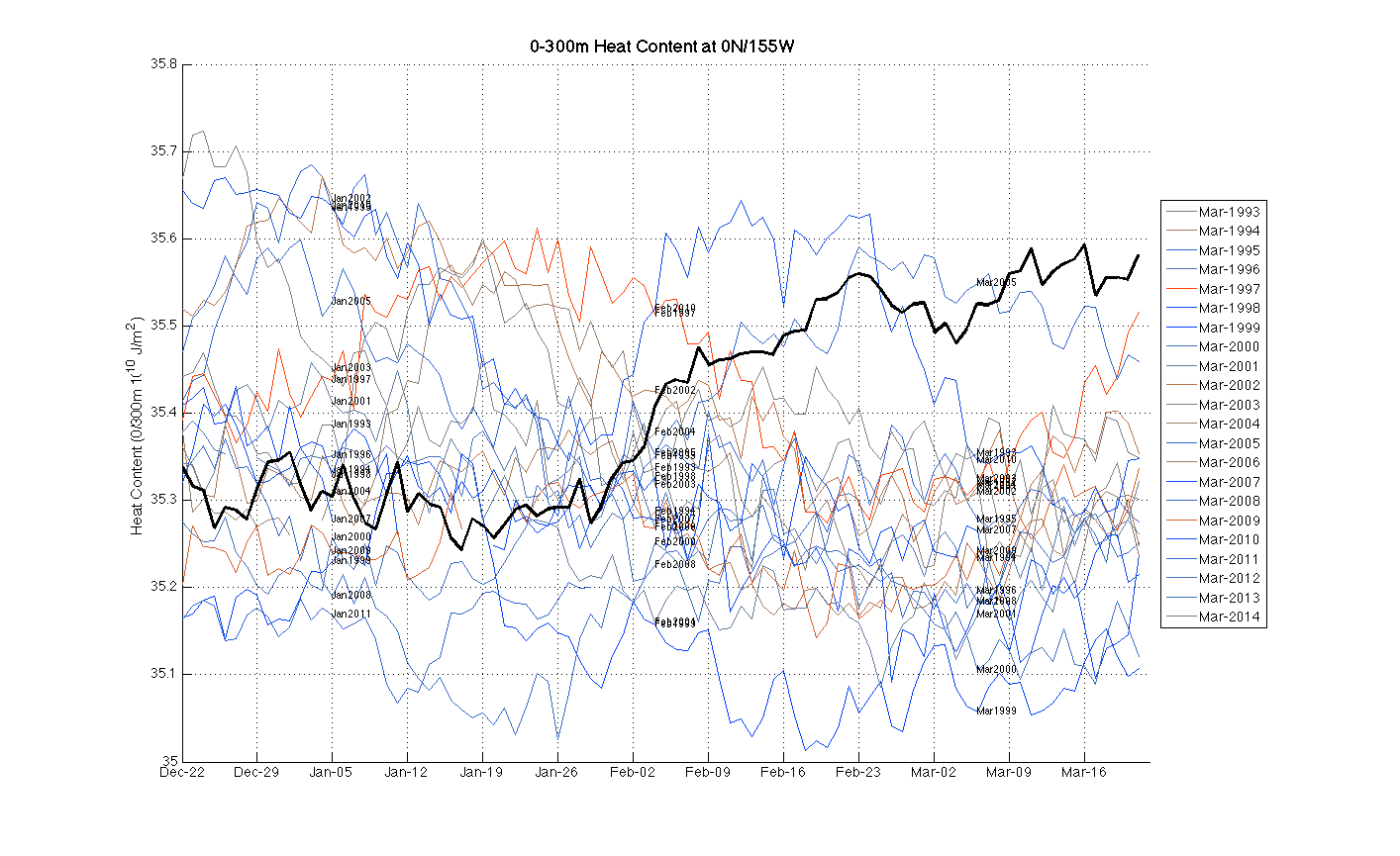
The theory about an El Nino fixing the stability problem in the Atlantic in my eyes might not do it this year, therefore I might throw in the towel months before it starts.

Kingarabian wrote:So we're ahead of 1997 now with that +0.1C reading.

What is the comparison?

For the last week of March in 1997, Nino 3.4 was at 0.0C.
0 likes   
RIP Kobe Bryant

User avatar
Ntxw
Storm2k Moderator
Storm2k Moderator
Posts: 22785
Joined: Wed Oct 21, 2009 6:34 pm
Location: DFW, Texas

Re: I wanted a La Nina

#3802 Postby Ntxw » Mon Mar 24, 2014 6:43 pm

Kingarabian wrote:For the last week of March in 1997, Nino 3.4 was at 0.0C.


Indeed both 1997 and 2014 started out cold in early March at -0.4C. Both have some of the most dramatic rises for ENSO 3.4 regarding this matter as the 0.5C rise last week to this week is not usual. Typically it's a slow step up. By the final week of April 1997 achieved +0.6C beginning what is the first trimonthly of El Nino threshold per ONI.
0 likes   
The above post and any post by Ntxw is NOT an official forecast and should not be used as such. It is just the opinion of the poster and may or may not be backed by sound meteorological data. It is NOT endorsed by any professional institution including Storm2k. For official information, please refer to NWS products.

  Help support Storm2K!
Help Support Storm2K

User avatar
Kingarabian
S2K Supporter
S2K Supporter
Posts: 15981
Joined: Sat Aug 08, 2009 3:06 am
Location: Honolulu, Hawaii

#3803 Postby Kingarabian » Mon Mar 24, 2014 7:23 pm

Our friend TropicalAnalystwx13 has posted this on Dr. Masters Wunderground Blog:

Image

The amount of ocean heat content in the Pacific subsurface continues to be the highest on record, beating values observed during the 1997-98 El Nino (the record holder; included in the image). An El Nino is almost inevitable by now; what remains to be seen is how strong it gets. There remains a good chance we see this become a strong El Nino (>1.5C).


Yet another variable that 2014 is beating 1997 in.
0 likes   
RIP Kobe Bryant

User avatar
Ntxw
Storm2k Moderator
Storm2k Moderator
Posts: 22785
Joined: Wed Oct 21, 2009 6:34 pm
Location: DFW, Texas

Re: ENSO: CPC 3/24/14 update=Nino 3.4 up to +0.1C

#3804 Postby Ntxw » Mon Mar 24, 2014 7:26 pm

Hammy wrote:I've noticed a westward expansion of the cool pool off of South America over the last week

http://www.ospo.noaa.gov/data/sst/anomaly/2014/anomp.3.24.2014.gif
compared to last week
http://www.ospo.noaa.gov/data/sst/anomaly/2014/anomp.3.17.2014.gif


This is the case. But like the other ENSO regions last month that saw dramatic cooling there is no foundation. We saw dramatic cool anomalies across 3.4 several weeks ago at the surface, it's been wiped out because there is no source to recharge it. We knew they were going to warm because of what was occurring below. It's too shallow and surface based. You need support from below or it won't hold when winds shift. What we see from 1+2 right now is the remnants of the small cold pool that was pushed up and out of the way by our resident warm pool expanding.
0 likes   
The above post and any post by Ntxw is NOT an official forecast and should not be used as such. It is just the opinion of the poster and may or may not be backed by sound meteorological data. It is NOT endorsed by any professional institution including Storm2k. For official information, please refer to NWS products.


  Help support Storm2K!

Help Support Storm2K


User avatar
Ntxw
Storm2k Moderator
Storm2k Moderator
Posts: 22785
Joined: Wed Oct 21, 2009 6:34 pm
Location: DFW, Texas

Re: ENSO: CPC 3/24/14 update=Nino 3.4 up to +0.1C

#3805 Postby Ntxw » Mon Mar 24, 2014 8:10 pm

cycloneye wrote:Here is a good graphic of information about the past El Nino events since 1957 to present. The big question is where will the 2014 El Nino will be in that graphic when it updates after this event is over. Anyone wants to guess the maximum strength of the 2014 event?

I will go with +2.1C

http://oi58.tinypic.com/aewapw.jpg


This is a fantastic graphic. Not just the strengths but look at when they get started. The big 3 began ONI AMJ. IMO this is the key to knowing how strong this possible ENSO event is going to be. We don't have to wait months and months, we'll know how strong it's likely to be very soon. If it doesn't start in April and/or May we can rule out super Nino. If it starts in the summer June through August good chance it will be mod. Any later, weak.
0 likes   
The above post and any post by Ntxw is NOT an official forecast and should not be used as such. It is just the opinion of the poster and may or may not be backed by sound meteorological data. It is NOT endorsed by any professional institution including Storm2k. For official information, please refer to NWS products.


  Help support Storm2K!

Help Support Storm2K


User avatar
Yellow Evan
Professional-Met
Professional-Met
Posts: 16143
Age: 27
Joined: Fri Jul 15, 2011 12:48 pm
Location: Henderson, Nevada/Honolulu, HI
Contact:

Re: ENSO: CPC 3/24/14 update=Nino 3.4 up to +0.1C

#3806 Postby Yellow Evan » Mon Mar 24, 2014 8:21 pm

Hammy wrote:I've noticed a westward expansion of the cool pool off of South America over the last week

http://www.ospo.noaa.gov/data/sst/anomaly/2014/anomp.3.24.2014.gif
compared to last week
http://www.ospo.noaa.gov/data/sst/anomaly/2014/anomp.3.17.2014.gif

ENSO 1+2 tends to fluctuate a bit more often than 3.4. I would not take too much stock into this.
0 likes   

User avatar
Cyclenall
Category 5
Category 5
Posts: 6666
Joined: Thu Jun 08, 2006 10:01 pm
Location: Ontario, Canada

Re: I wanted a La Nina

#3807 Postby Cyclenall » Mon Mar 24, 2014 8:25 pm

Ntxw wrote:
Kingarabian wrote:For the last week of March in 1997, Nino 3.4 was at 0.0C.


Indeed both 1997 and 2014 started out cold in early March at -0.4C. Both have some of the most dramatic rises for ENSO 3.4 regarding this matter as the 0.5C rise last week to this week is not usual. Typically it's a slow step up. By the final week of April 1997 achieved +0.6C beginning what is the first trimonthly of El Nino threshold per ONI.

So if we see another jump of Nino 3.4 by 0.5ºC or more in next week's update, we'll know something ridiculous is starting.
0 likes   

User avatar
Ntxw
Storm2k Moderator
Storm2k Moderator
Posts: 22785
Joined: Wed Oct 21, 2009 6:34 pm
Location: DFW, Texas

Re: ENSO: CPC 3/24/14 update=Nino 3.4 up to +0.1C

#3808 Postby Ntxw » Mon Mar 24, 2014 10:04 pm

ESPI continues to run high, still +0.70s. Drought intensifying over the Maritime Continent and Australia. The Pacific continues to get wetter. This is the misfortune of any El Nino, especially the bigger ones. A lot of suffering for a highly populated region of Southern and SE Asia and only gets worse if it continues on the path. Well documented of disease and famine in this part of the world with warm ENSO.

Image
0 likes   
The above post and any post by Ntxw is NOT an official forecast and should not be used as such. It is just the opinion of the poster and may or may not be backed by sound meteorological data. It is NOT endorsed by any professional institution including Storm2k. For official information, please refer to NWS products.


  Help support Storm2K!

Help Support Storm2K


User avatar
cycloneye
Admin
Admin
Posts: 145327
Age: 68
Joined: Thu Oct 10, 2002 10:54 am
Location: San Juan, Puerto Rico

Re: ENSO: CPC 3/24/14 update=Nino 3.4 up to +0.1C

#3809 Postby cycloneye » Mon Mar 24, 2014 10:13 pm

30 day SOI is slightly up from last weeks -13.4. Ntxw ,nothing to open eyes there right?

Image
0 likes   
Visit the Caribbean-Central America Weather Thread where you can find at first post web cams,radars
and observations from Caribbean basin members Click Here

User avatar
TropicalAnalystwx13
Category 5
Category 5
Posts: 2109
Age: 27
Joined: Tue Jul 19, 2011 8:20 pm
Location: Wilmington, NC
Contact:

#3810 Postby TropicalAnalystwx13 » Mon Mar 24, 2014 10:47 pm

The CFS is forecasting a return to easterly trades as we enter April, which would slow down any warming along the equatorial Pacific during that time. It's nothing to freak out, though, as westerly winds return in earnest by week 4.
0 likes   

dexterlabio
Category 5
Category 5
Posts: 3468
Joined: Sat Oct 24, 2009 11:50 pm

Re: ENSO: CPC 3/24/14 update=Nino 3.4 up to +0.1C

#3811 Postby dexterlabio » Mon Mar 24, 2014 11:53 pm

All eyes will be on WPAC in the coming days or weeks. If we're really expecting a "carbon copy", or a stronger version perhaps, of the 1997 Nino, we should look out for significant tropical development in this region, if there'll be any...like what happened during Super typhoon Isa.

So far the GFS has been on and off showing a strong typhoon in the long range. I personally don't put weight on long range model forecast right now. 2 weeks ago the models showed a strong typhoon east of the Philippines but later on only turned out to be a tropical depression (TD 04W/"Caloy").
0 likes   
Personal Forecast Disclaimer:
The posts in this forum are NOT official forecast and should not be used as such. They are just the opinion of the poster and may or may not be backed by sound meteorological data. They are NOT endorsed by any professional institution or storm2k.org. For official information, please refer to the NHC and NWS products.

User avatar
cycloneye
Admin
Admin
Posts: 145327
Age: 68
Joined: Thu Oct 10, 2002 10:54 am
Location: San Juan, Puerto Rico

Re: ENSO Updates

#3812 Postby cycloneye » Tue Mar 25, 2014 6:55 am

The Autralians update:

Increased chance of El Niño in 2014

Issued on Tuesday 25 March 2014 | Product Code IDCKGEWWOO

While the tropical Pacific Ocean remains El Niño–Southern Oscillation (ENSO) neutral, the chance of an El Niño occurring in 2014 has increased. The latest climate model survey by the Bureau shows that the tropical Pacific is likely to warm in the coming months, with most models showing sea surface temperatures reaching El Niño thresholds during the southern hemisphere winter.

Observations indicate that the tropical Pacific Ocean is currently warming. Following two strong westerly wind bursts since the start of the year, waters below the surface of the tropical Pacific have warmed significantly over the past two months. This has led to some warming at the surface, with further warming expected in the coming weeks. The Southern Oscillation Index (SOI) has dropped to –13—the lowest 30-day value since March 2010—but would need to remain firmly negative for several weeks to indicate the atmosphere and ocean are reinforcing each other.

El Niño is often, but not always, associated with below normal rainfall across large parts of southern and inland eastern Australia during the second half of the year. Daytime temperatures also tend to be above normal over southern Australia.

http://www.bom.gov.au/climate/enso/
0 likes   
Visit the Caribbean-Central America Weather Thread where you can find at first post web cams,radars
and observations from Caribbean basin members Click Here

User avatar
wxman57
Moderator-Pro Met
Moderator-Pro Met
Posts: 22979
Age: 67
Joined: Sat Jun 21, 2003 8:06 pm
Location: Houston, TX (southwest)

Re: ENSO Updates

#3813 Postby wxman57 » Tue Mar 25, 2014 9:01 am

Very interesting if you go back to March of 1997 and check the March 12th and March 9th Nino 3.4 values and compare to the current month:

http://www.cpc.ncep.noaa.gov/data/indices/wksst8110.for

Here are the readings from 1997:
March 12th: -0.4C
March 19th: +0.1C

And from 2014:
March 12th: -0.4C
March 19th: +0.1C

Notice any similarities? ;-)

There's a huge mass of warm sub-surface water about to make its appearance. Anomalies may top +1.0C by June.
0 likes   

User avatar
cycloneye
Admin
Admin
Posts: 145327
Age: 68
Joined: Thu Oct 10, 2002 10:54 am
Location: San Juan, Puerto Rico

Re: ENSO Updates

#3814 Postby cycloneye » Tue Mar 25, 2014 10:03 am

What about +0.3C to round it? Yesterday at CPC update it was at +0.1C.

Image
0 likes   
Visit the Caribbean-Central America Weather Thread where you can find at first post web cams,radars
and observations from Caribbean basin members Click Here

User avatar
Ntxw
Storm2k Moderator
Storm2k Moderator
Posts: 22785
Joined: Wed Oct 21, 2009 6:34 pm
Location: DFW, Texas

Re: ENSO Updates

#3815 Postby Ntxw » Tue Mar 25, 2014 10:14 am

wxman57 wrote:Very interesting if you go back to March of 1997 and check the March 12th and March 9th Nino 3.4 values and compare to the current month:

http://www.cpc.ncep.noaa.gov/data/indices/wksst8110.for

Here are the readings from 1997:
March 12th: -0.4C
March 19th: +0.1C

And from 2014:
March 12th: -0.4C
March 19th: +0.1C

Notice any similarities? ;-)

There's a huge mass of warm sub-surface water about to make its appearance. Anomalies may top +1.0C by June.


Dang aren't you being a little bullish there wxman57 :wink: ?+1C by June! That isn't even the real peak of ENSO at that pace you must be wanting +2C by September and +3C in December! You're trying to destroy the Caribbean with 70-80kts wind shear aren't you? :lol:

No doubt this is one of the fastest, strongest sub-surface warm pool mass we have seen since records, and the kelvin waves have been the strongest to boot.
0 likes   
The above post and any post by Ntxw is NOT an official forecast and should not be used as such. It is just the opinion of the poster and may or may not be backed by sound meteorological data. It is NOT endorsed by any professional institution including Storm2k. For official information, please refer to NWS products.


  Help support Storm2K!

Help Support Storm2K


euro6208

Re: ENSO Updates

#3816 Postby euro6208 » Tue Mar 25, 2014 11:06 am

Firefighters battle grass fire on Cross Island Road

:uarrow:

Huge drought over the western pacific and guam is now experiencing the effects due to upcoming el nino!

literally hot as hell over here...
0 likes   

stephen23
Category 1
Category 1
Posts: 341
Joined: Sat Aug 04, 2012 10:57 pm
Location: North Fort Worth

Re: ENSO Updates

#3817 Postby stephen23 » Tue Mar 25, 2014 12:19 pm

Could one of the pro explain to me. I see that ENSO 3.4 has warmed up quite a bit but I'm still trying to find out why so much comparison to 1997. When I look back at sst anomaly for the same time in 1997 I really don't see that much comparison. In 1997 the waters off of South America were already warm by this point in time as well as warm water had already passed south of the equator.
Image


And 2014:
Image


Would a better analog Possibly be 1957:

1957 -0.3 0.1 0.4 0.7 0.9 1.0 1.1 1.2 1.2 1.3 1.5 1.8
Last edited by stephen23 on Tue Mar 25, 2014 12:35 pm, edited 2 times in total.
0 likes   
Personal Forecast Disclaimer:
The posts in this forum are NOT official forecast and should not be used as such. They are just the opinion of the poster and may or may not be backed by sound meteorological data. They are NOT endorsed by any professional institution or storm2k.org. For official information, please refer to the NHC and NWS products.

User avatar
Ntxw
Storm2k Moderator
Storm2k Moderator
Posts: 22785
Joined: Wed Oct 21, 2009 6:34 pm
Location: DFW, Texas

Re: ENSO Updates

#3818 Postby Ntxw » Tue Mar 25, 2014 12:25 pm

stephen23 wrote:Could one of the pro explain to me. I see that ENSO 3.4 has warmed up quite a bit but I'm still trying to find out why so much comparison to 1997. When I look back at sst anomaly for the same time in 1997 I really don't see that much comparison. In 1997 the waters off of South America were already super warm by this point in time as well as warm water had already passed south of the equator.


If you have been following ENSO, and the many tweets, posts, blogs from professionals as well as the CPC you will understand that ENSO is more than just what the SST's look like. It is about what the atmosphere is doing and what the ocean is doing below the surface as well. SST's change quickly with winds and weather patterns. When looking at everything as a whole (many many posts) the leading events to 2014 (heat content, rise of ENSO, Oceanic Kelvin waves, MJO waves) the magnitude is really only comparable to the early months of 1997, perhaps 1972. Will it continue to match? No one knows but thus far it's the best fit.

And to your maps, why are you comparing March 2014 to May 1997? You have to keep the variables the same go for March 1997.

For example, a month ago if one didn't see what was below and above just the surface would anyone would've guessed we were heading for an El Nino?

Image
0 likes   
The above post and any post by Ntxw is NOT an official forecast and should not be used as such. It is just the opinion of the poster and may or may not be backed by sound meteorological data. It is NOT endorsed by any professional institution including Storm2k. For official information, please refer to NWS products.


  Help support Storm2K!

Help Support Storm2K


stephen23
Category 1
Category 1
Posts: 341
Joined: Sat Aug 04, 2012 10:57 pm
Location: North Fort Worth

Re: ENSO Updates

#3819 Postby stephen23 » Tue Mar 25, 2014 1:00 pm

Ntxw wrote:
stephen23 wrote:Could one of the pro explain to me. I see that ENSO 3.4 has warmed up quite a bit but I'm still trying to find out why so much comparison to 1997. When I look back at sst anomaly for the same time in 1997 I really don't see that much comparison. In 1997 the waters off of South America were already super warm by this point in time as well as warm water had already passed south of the equator.


If you have been following ENSO, and the many tweets, posts, blogs from professionals as well as the CPC you will understand that ENSO is more than just what the SST's look like. It is about what the atmosphere is doing and what the ocean is doing below the surface as well. SST's change quickly with winds and weather patterns. When looking at everything as a whole (many many posts) the leading events to 2014 (heat content, rise of ENSO, Oceanic Kelvin waves, MJO waves) the magnitude is really only comparable to the early months of 1997, perhaps 1972. Will it continue to match? No one knows but thus far it's the best fit.

And to your maps, why are you comparing March 2014 to May 1997? You have to keep the variables the same go for March 1997.

For example, a month ago if one didn't see what was below and above just the surface would anyone would've guessed we were heading for an El Nino?

http://i60.tinypic.com/23r009x.gif


Ok. I understand now Ntxw. Now one more question. Why is there a difference on the Tropical Tidbit site and the site that Wxman had above for the the sst values on March 19th . Tropical Tidbit site had March 19th at -.082. The site that Wxman has above for March 19th has .1. Am I missing something that is calculated in here. Just trying to learn and figure this stuff out. This is my past time when I'm not out doing catastrophe work.

Image
0 likes   
Personal Forecast Disclaimer:
The posts in this forum are NOT official forecast and should not be used as such. They are just the opinion of the poster and may or may not be backed by sound meteorological data. They are NOT endorsed by any professional institution or storm2k.org. For official information, please refer to the NHC and NWS products.

User avatar
wxman57
Moderator-Pro Met
Moderator-Pro Met
Posts: 22979
Age: 67
Joined: Sat Jun 21, 2003 8:06 pm
Location: Houston, TX (southwest)

Re: ENSO Updates

#3820 Postby wxman57 » Tue Mar 25, 2014 1:47 pm

I don't know why there would be a difference unless the two sites are analyzing slightly different Nino 3.4 regions or more likely the observation dates are different. I'm using NCEP's weekly temperature page:

Image

Here's the latest on Tropical Tidbits (+.272C):

Image
0 likes   


Return to “Talkin' Tropics”

Who is online

Users browsing this forum: NotSparta and 27 guests