Although the incredible rainfall is the main threat...
SEL9
URGENT - IMMEDIATE BROADCAST REQUESTED
TORNADO WATCH NUMBER 119
NWS STORM PREDICTION CENTER NORMAN OK
955 PM CDT TUE APR 29 2014
THE NWS STORM PREDICTION CENTER HAS ISSUED A
* TORNADO WATCH FOR PORTIONS OF
FLORIDA PANHANDLE
COASTAL WATERS
* EFFECTIVE THIS TUESDAY NIGHT AND WEDNESDAY MORNING FROM 955 PM
UNTIL 200 AM CDT.
* PRIMARY THREATS INCLUDE...
A COUPLE TORNADOES POSSIBLE
ISOLATED DAMAGING WIND GUSTS TO 70 MPH POSSIBLE
ISOLATED LARGE HAIL EVENTS TO 1.5 INCHES IN DIAMETER POSSIBLE
THE TORNADO WATCH AREA IS APPROXIMATELY ALONG AND 50 STATUTE
MILES NORTH AND SOUTH OF A LINE FROM 40 MILES WEST OF PANAMA CITY
FLORIDA TO 30 MILES EAST OF PANAMA CITY FLORIDA. FOR A COMPLETE
DEPICTION OF THE WATCH SEE THE ASSOCIATED WATCH OUTLINE UPDATE
(WOUS64 KWNS WOU9).
PRECAUTIONARY/PREPAREDNESS ACTIONS...
REMEMBER...A TORNADO WATCH MEANS CONDITIONS ARE FAVORABLE FOR
TORNADOES AND SEVERE THUNDERSTORMS IN AND CLOSE TO THE WATCH
AREA. PERSONS IN THESE AREAS SHOULD BE ON THE LOOKOUT FOR
THREATENING WEATHER CONDITIONS AND LISTEN FOR LATER STATEMENTS
AND POSSIBLE WARNINGS.
&&
DISCUSSION...A LARGE SUPERCELL THUNDERSTORM OVER THE WESTERN FL
PANHANDLE WILL MOVE SLOWLY EASTWARD INTO THE WATCH AREA LATE THIS
EVENING. STRONG LOW LEVEL VERTICAL SHEAR AND AMPLE MOISTURE MAY
ALLOW THE STORM TO MAINTAIN ORGANIZATION AND INTENSITY. ISOLATED
TORNADOES AND LOCALLY DAMAGING WINDS ARE THE MAIN THREATS.
AVIATION...TORNADOES AND A FEW SEVERE THUNDERSTORMS WITH HAIL
SURFACE AND ALOFT TO 1.5 INCHES. EXTREME TURBULENCE AND SURFACE
WIND GUSTS TO 60 KNOTS. A FEW CUMULONIMBI WITH MAXIMUM TOPS TO
500. MEAN STORM MOTION VECTOR 27025.
...HART
Significant Severe Weather Outbreak Possible 04/26-30/2014
Moderator: S2k Moderators
Forum rules

The posts in this forum are NOT official forecast and should not be used as such. They are just the opinion of the poster and may or may not be backed by sound meteorological data. They are NOT endorsed by any professional institution or STORM2K.

Escambia County, FL EOC has declared a local state of emergency for the next 24 hours- schools are closed and they're asking everyone to stay home and off roads until hopefully flood waters recede. I-10 is shut down a few miles east of the AL-FL state line.
61K lightning strike in the past hour on the local radar system.
61K lightning strike in the past hour on the local radar system.
0 likes

WTF
CrazyC83 wrote:Some areas around Pensacola have had around 16 inches of rain tonight alone...incredible.
Its been an extreme weather day there, a possible tornado with the best supercell I've ever seen in Florida with a strong couplet moving through parts of northern Pensacola. That intense convection as been sitting in that spot all day long and just pouring non-stop as if a TS was sitting there. I have no idea what is causing it and how a powerful supercell with a possible tornado formed embedded within just a rained-out atmosphere while large areas of MS, AL with full sunlight most of the day and a recovered airmass barely had any TOR warnings! The mysteries of weather run deep.
0 likes

What is Going on Down There?
Live Coverage: http://www.weartv.com/news/features/live-news/
People are dying now, flood waters are carrying away cars and submerging them in some cases, water coming into people's homes . So last year it was OKC's turn on May 31-June 1 to have immense training and its Pen's turn but they get this a bit more often as 2011 or 2012 had a big event too.

 Most impressive supercell of the day, why its there is unknown.

Some nice curves and snaking with that cell.


Nick Wiltgen @WxNick 4h - Oh my. 5.24" rain in 45 min at Pensacola airport… highest rain total I've ever seen in a METAR in less than 1 hr in my 16-yr career #flood
That has to be a record of some sort for Pen, that is unimaginable!!!!
People are dying now, flood waters are carrying away cars and submerging them in some cases, water coming into people's homes
Nick Wiltgen @WxNick 4h - Oh my. 5.24" rain in 45 min at Pensacola airport… highest rain total I've ever seen in a METAR in less than 1 hr in my 16-yr career #flood
That has to be a record of some sort for Pen, that is unimaginable!!!!
0 likes
-
SeGaBob
0 likes

-
cycloneye

- Admin

- Posts: 149367
- Age: 69
- Joined: Thu Oct 10, 2002 10:54 am
- Location: San Juan, Puerto Rico
Re: Significant Severe Weather Outbreak Possible 04/26-30/2014
The Mayflower-Villona Tornado was ranked as EF-4. It tracked for around 41 miles and caused 14 deaths.
0 likes
Visit the Caribbean-Central America Weather Thread where you can find at first post web cams,radars
and observations from Caribbean basin members Click Here
and observations from Caribbean basin members Click Here
-
CrazyC83
- Professional-Met

- Posts: 34315
- Joined: Tue Mar 07, 2006 11:57 pm
- Location: Deep South, for the first time!
High end EF-4 for Mayflower/Vilonia, winds around 190 mph. Interesting is that after the first occlusion, it produced four tornadoes, strongest EF-2, and went up and down. I was expecting another long track tornado, guessing around EF-3, instead of such.
Some other notables so far:
Tupelo - still holding EF-3. I hadn't seen any damage supporting higher, we shall see.
Jackson metro - also currently EF-3. Didn't see a lot of pics out of that one, so that might stand.
Huntland, TN - currently a high-end EF-3. I could see it being upgraded perhaps.
Bessemer - surveyed as an EF-2.
0 likes
-
TropicalAnalystwx13

- Category 5

- Posts: 2109
- Age: 28
- Joined: Tue Jul 19, 2011 8:20 pm
- Location: Wilmington, NC
- Contact:
Re:
CrazyC83 wrote:Bessemer - surveyed as an EF-2.
So all those trying to hype the fact this twister didn't enter in the Birmingham metropolis, there you go. Its not like it was an EF5 or something
TropicalAnalystwx13 wrote:At least 62 confirmed tornadoes so far this outbreak, including 9 EF3s and 2 EF4s (though Vilonia is debatable).
Debatable like a possible EF5? Lets just call it an EF4.9 (190 mph) and settle
The Pensacola extreme flooding disaster alone was estimated in excess of $100 million in damage. On the main wiki article, there are amazing stats, facts, and more about how rare the event was and it even surpassed what I guessed...once in a 100 year event minimum! Possible 1-in-200 year event with the insane rainfall burst during that 45 min period being a 1-in-500 year event...okay
0 likes
-
WeatherGuesser
- Category 5
- Posts: 2672
- Joined: Tue Jun 29, 2010 6:46 am
Re: Re:
Cyclenall wrote: The Pensacola extreme flooding disaster alone was estimated in excess of $100 million in damage. On the main wiki article, there are amazing stats, facts, and more about how rare the event was and it even surpassed what I guessed...once in a 100 year event minimum! Possible 1-in-200 year event with the insane rainfall burst during that 45 min period being a 1-in-500 year event...okay
* Washington, D.C., Baltimore, Philadelphia, and New York City all received approximately 5 inches of rain since Monday. That’s the same amount of rain that has fallen in Los Angeles this entire year (5.11″) so far.
* The 20.47 inches that fell in Pensacola, Florida (Monday to Wednesday) is more rain than Los Angeles has received in 2012, 2013, and 2014 combined (16.86 inches)
http://www.washingtonpost.com/blogs/cap ... situation/
0 likes
-
TropicalAnalystwx13
- Category 5
- Posts: 2109
- Age: 28
- Joined: Tue Jul 19, 2011 8:20 pm
- Location: Wilmington, NC
- Contact:
Re: Re:
Cyclenall wrote:CrazyC83 wrote:Bessemer - surveyed as an EF-2.
So all those trying to hype the fact this twister didn't enter in the Birmingham metropolis, there you go. Its not like it was an EF5 or something. I'm not directing this solely at this board, but the greater online weather presence in which such things as "The big story of the night was the downtown Birmingham area being "saved" by a rapid cycling supercell" and "That was TOO close!" and "What a miracle! Dodged a bullet!"
TropicalAnalystwx13 wrote:At least 62 confirmed tornadoes so far this outbreak, including 9 EF3s and 2 EF4s (though Vilonia is debatable).
Debatable like a possible EF5? Lets just call it an EF4.9 (190 mph) and settle. If we do rounding then you have your 5
.
The Pensacola extreme flooding disaster alone was estimated in excess of $100 million in damage. On the main wiki article, there are amazing stats, facts, and more about how rare the event was and it even surpassed what I guessed...once in a 100 year event minimum! Possible 1-in-200 year event with the insane rainfall burst during that 45 min period being a 1-in-500 year event...okay
Yes. Several houses obliterated with ground scouring right next to the foundations doesn't scream EF4 to me.

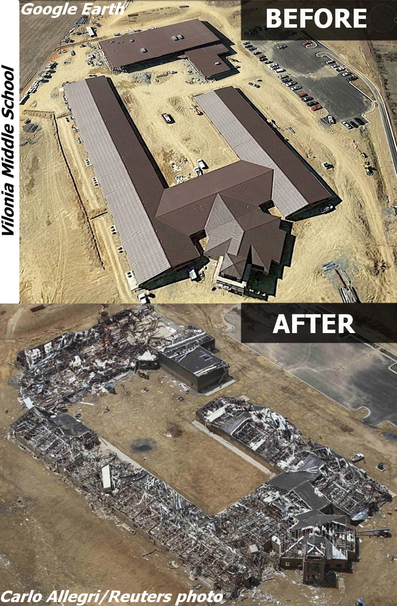
Nor does a *just-built* middle school being almost completely leveled.
0 likes
-
vbhoutex

- Storm2k Executive
- Posts: 29147
- Age: 74
- Joined: Wed Oct 09, 2002 11:31 pm
- Location: Cypress, TX
- Contact:
Re:
EF-5bigj wrote:Sometimes I think the EF scale has consistency issues...ground scouring,houses obliterated down to the slad sounds EF-5 to me. They rated the Louisville,MS tornado a EF-4 also but again houses leveled to the slab ect. How does one rate EF-5 damage as EF-4 damage?
The scale takes into consideration how the homes are built iirc. Perhaps that is the difference.
Based on what I know about the EF scale the school is EF-4 as there is no scouring or walls completely wiped away. Is it total destruction? Yes it is in our eyes, but based on the scale I think it is EF4. JMHO. I am not an expert however, so if one of our expert pros wants to chime in please do.
0 likes
Skywarn, C.E.R.T.
Please click below to donate to STORM2K to help with the expenses of keeping the site going:

Please click below to donate to STORM2K to help with the expenses of keeping the site going:
-
vbhoutex
- Storm2k Executive
- Posts: 29147
- Age: 74
- Joined: Wed Oct 09, 2002 11:31 pm
- Location: Cypress, TX
- Contact:
Re:
EF-5bigj wrote:Ahh I see so badly built homes ect.
Not necessarily badly built as opposed to older less stringent codes and/or older homes that have deteriorated.
0 likes
Skywarn, C.E.R.T.
Please click below to donate to STORM2K to help with the expenses of keeping the site going:
Please click below to donate to STORM2K to help with the expenses of keeping the site going:
Return to “USA & Caribbean Weather”
Who is online
Users browsing this forum: Google Adsense [Bot], South Texas Storms and 72 guests