Texas Spring-2014

U.S. & Caribbean Weather Discussions and Severe Weather Events

Moderator: S2k Moderators

Forum rules

The posts in this forum are NOT official forecast and should not be used as such. They are just the opinion of the poster and may or may not be backed by sound meteorological data. They are NOT endorsed by any professional institution or STORM2K.

Help Support Storm2K
Message
Author
User avatar
Tireman4
S2K Supporter
S2K Supporter
Posts: 5853
Age: 59
Joined: Fri Jun 30, 2006 1:08 pm
Location: Humble, Texas
Contact:

Re: Re:

#661 Postby Tireman4 » Fri May 02, 2014 1:48 pm

Portastorm wrote:
dhweather wrote:GFS and Euro look promising for a significant rain for a large part of the state in the 8-10 day range. The only problem is models in the 8-10 day range are higher than half the voters in Colorado or Washington.


The 1,440-hour GFS shows a Cat 5 in the Gulf!!! :eek:


Shoot, did you see the 2,440 hour GFS. That one shows a snowstorm in Houston and Dallas. :P
0 likes   

weatherdude1108
Category 5
Category 5
Posts: 4228
Joined: Tue Dec 13, 2011 1:04 pm
Location: Northwest Austin/Cedar Park, TX

Re: Re:

#662 Postby weatherdude1108 » Fri May 02, 2014 2:20 pm

Tireman4 wrote:
Portastorm wrote:
dhweather wrote:GFS and Euro look promising for a significant rain for a large part of the state in the 8-10 day range. The only problem is models in the 8-10 day range are higher than half the voters in Colorado or Washington.


The 1,440-hour GFS shows a Cat 5 in the Gulf!!! :eek:


Shoot, did you see the 2,440 hour GFS. That one shows a snowstorm in Houston and Dallas. :P

:roflmao:
Y'all are cracking me up.
0 likes   

User avatar
Portastorm
Storm2k Moderator
Storm2k Moderator
Posts: 9914
Age: 63
Joined: Fri Jul 11, 2003 9:16 am
Location: Round Rock, TX
Contact:

Re: Texas Spring-2014

#663 Postby Portastorm » Fri May 02, 2014 3:52 pm

Our friends in New Braunfels (NWS EWX) had some interesting things to say this afternoon about next week:

.LONG TERM (SUNDAY THROUGH FRIDAY)...
A DEEPENING UPSTREAM TROUGH WILL CONTINUE TO INCREASE SOUTHERLY
WINDS SUNDAY WITH THE STILL WARM AND DRY AFTERNOON AIR LEADING TO
MORE FIRE SPREAD CONCERNS. GULF MOISTURE RETURN IS EXPECTED TO
PRODUCE BRIEF LOW CLOUDS AND WARMER MIN TEMPERATURES BY MONDAY
MORNING...WITH MOISTURE GRADUALLY DEEPENING TROUGH WEDNESDAY. THE
APPROACHING TROUGH AND NOCTURNAL LOW LEVEL WINDS COULD PRODUCE A
FEW SPRINKLES NEAR THE ESCARPMENT AS EARLY AS TUESDAY MORNING...BUT
RAIN CHANCES WILL BE LEFT OUT OF THE FORECAST UNTIL WEDNESDAY
MORNING. MODEL HANDLING OF THE TROUGH HAS CONVERGED ON A SCENARIO
TO SUGGEST THE CANADIAN TO BE THE MOST CONSISTENT...WITH THE ECMWF
BECOMING LESS CUT OFF WITH THE LOW AND THE GFS BECOMING LESS
PROGRESSIVE AND SHALLOW WITH THE OPEN TROUGH. WHILE THIS
CONVERGENCE WOULD SUGGEST A PROMISING SHOT OF MUCH NEEDED
RAIN...THE CONCERN HERE IS STILL A FALSE PROMISE THAT COULD EASILY
BE DASHED BY A SLIGHT TROUGH DISPLACEMENT NORTHWARD...AND ANOTHER
DRY SLOT DISAPPOINTMENT. WILL CAP POPS AT 20 FOR THE EXTENDED AN
HOPE THAT THE MODEL AGREEMENT CARRIES OVER INTO THE WEEKEND RUNS.

ON THE OPTIMISTIC POINT OF VIEW...BOTH THE GFS AND ECMWF SHOW A WIDE
WINDOW OF OPPORTUNITY FROM WEDNESDAY THROUGH FRIDAY...BOTH WITH A
LEAD SHORTWAVE AND A STRONGER TRAILING TROUGH. FINALLY...AN
INTERESTING TROPICAL DISTURBANCE FEATURE IS SHOWN BY RECENT RUNS
OF THE ECMWF...CANADIAN...AND NOGAPS TO APPROACH SRN MEXICO COULD
ADD TO PRECIPITABLE WATER VALUES SHOULD THE DEEPER SOLUTION FOR
FRIDAY PREVAIL. NORMALLY THIS COULD BE DISREGARDED SO EARLY IN THE
YEAR...BUT WARM SST VALUES AROUND 30 DEG C AND A POSITIVE ANOMALY
FIELD WAS NOTED OVER THE PACIFIC COAST OF MEXICO.
0 likes   
Any forecasts under my name are to be taken with a grain of salt. Get your best forecasts from the National Weather Service and National Hurricane Center.

User avatar
wxman57
Moderator-Pro Met
Moderator-Pro Met
Posts: 22978
Age: 67
Joined: Sat Jun 21, 2003 8:06 pm
Location: Houston, TX (southwest)

Re: Re:

#664 Postby wxman57 » Fri May 02, 2014 3:54 pm

Tireman4 wrote:
Portastorm wrote:
dhweather wrote:GFS and Euro look promising for a significant rain for a large part of the state in the 8-10 day range. The only problem is models in the 8-10 day range are higher than half the voters in Colorado or Washington.


The 1,440-hour GFS shows a Cat 5 in the Gulf!!! :eek:


Shoot, did you see the 2,440 hour GFS. That one shows a snowstorm in Houston and Dallas. :P


Highly unlikely, 2440 hours is a little over 101 days - sometime in August.
0 likes   

weatherdude1108
Category 5
Category 5
Posts: 4228
Joined: Tue Dec 13, 2011 1:04 pm
Location: Northwest Austin/Cedar Park, TX

Re: Texas Spring-2014

#665 Postby weatherdude1108 » Fri May 02, 2014 4:22 pm

Portastorm wrote:Our friends in New Braunfels (NWS EWX) had some interesting things to say this afternoon about next week:

.LONG TERM (SUNDAY THROUGH FRIDAY)...
A DEEPENING UPSTREAM TROUGH WILL CONTINUE TO INCREASE SOUTHERLY
WINDS SUNDAY WITH THE STILL WARM AND DRY AFTERNOON AIR LEADING TO
MORE FIRE SPREAD CONCERNS. GULF MOISTURE RETURN IS EXPECTED TO
PRODUCE BRIEF LOW CLOUDS AND WARMER MIN TEMPERATURES BY MONDAY
MORNING...WITH MOISTURE GRADUALLY DEEPENING TROUGH WEDNESDAY. THE
APPROACHING TROUGH AND NOCTURNAL LOW LEVEL WINDS COULD PRODUCE A
FEW SPRINKLES NEAR THE ESCARPMENT AS EARLY AS TUESDAY MORNING...BUT
RAIN CHANCES WILL BE LEFT OUT OF THE FORECAST UNTIL WEDNESDAY
MORNING. MODEL HANDLING OF THE TROUGH HAS CONVERGED ON A SCENARIO
TO SUGGEST THE CANADIAN TO BE THE MOST CONSISTENT...WITH THE ECMWF
BECOMING LESS CUT OFF WITH THE LOW AND THE GFS BECOMING LESS
PROGRESSIVE AND SHALLOW WITH THE OPEN TROUGH. WHILE THIS
CONVERGENCE WOULD SUGGEST A PROMISING SHOT OF MUCH NEEDED
RAIN...THE CONCERN HERE IS STILL A FALSE PROMISE THAT COULD EASILY
BE DASHED BY A SLIGHT TROUGH DISPLACEMENT NORTHWARD...AND ANOTHER
DRY SLOT DISAPPOINTMENT. WILL CAP POPS AT 20 FOR THE EXTENDED AN
HOPE THAT THE MODEL AGREEMENT CARRIES OVER INTO THE WEEKEND RUNS.

ON THE OPTIMISTIC POINT OF VIEW...BOTH THE GFS AND ECMWF SHOW A WIDE
WINDOW OF OPPORTUNITY FROM WEDNESDAY THROUGH FRIDAY...BOTH WITH A
LEAD SHORTWAVE AND A STRONGER TRAILING TROUGH. FINALLY...AN
INTERESTING TROPICAL DISTURBANCE FEATURE IS SHOWN BY RECENT RUNS
OF THE ECMWF...CANADIAN...AND NOGAPS TO APPROACH SRN MEXICO COULD
ADD TO PRECIPITABLE WATER VALUES SHOULD THE DEEPER SOLUTION FOR
FRIDAY PREVAIL. NORMALLY THIS COULD BE DISREGARDED SO EARLY IN THE
YEAR...BUT WARM SST VALUES AROUND 30 DEG C AND A POSITIVE ANOMALY
FIELD WAS NOTED OVER THE PACIFIC COAST OF MEXICO.


:uarrow:
I saw that! I was about to post it. You beat me again! :wink: They are being cautious also.
0 likes   

User avatar
Tireman4
S2K Supporter
S2K Supporter
Posts: 5853
Age: 59
Joined: Fri Jun 30, 2006 1:08 pm
Location: Humble, Texas
Contact:

Re: Re:

#666 Postby Tireman4 » Fri May 02, 2014 6:40 pm

[
The 1,440-hour GFS shows a Cat 5 in the Gulf!!! :eek:[/quote]

Shoot, did you see the 2,440 hour GFS. That one shows a snowstorm in Houston and Dallas. :P[/quote]

Highly unlikely, 2440 hours is a little over 101 days - sometime in August.[/quote]

Well it is the GFS sir. :)
0 likes   

User avatar
Ntxw
Storm2k Moderator
Storm2k Moderator
Posts: 22785
Joined: Wed Oct 21, 2009 6:34 pm
Location: DFW, Texas

#667 Postby Ntxw » Fri May 02, 2014 11:04 pm

Quick update of background stuff. We have not seen any -PDO readings this year, all have been +PDO gradually rising. April's update will come out in a little over a week, we're going to see another big +PDO reading. As you can see below the GOA warm pool has morphed into a full fledged +PDO configuration of the Pacific from the north, the El Nino coming from the south.

May is going to see some record blocking in Alaska/GOA. Something we have been so accustomed to the past year, just another day in the park.

Image
0 likes   
The above post and any post by Ntxw is NOT an official forecast and should not be used as such. It is just the opinion of the poster and may or may not be backed by sound meteorological data. It is NOT endorsed by any professional institution including Storm2k. For official information, please refer to NWS products.

  Help support Storm2K!
Help Support Storm2K

User avatar
dhweather
S2K Supporter
S2K Supporter
Posts: 6199
Joined: Sat Aug 14, 2004 9:29 pm
Location: Heath, TX
Contact:

Re: Re:

#668 Postby dhweather » Sat May 03, 2014 7:15 am

Portastorm wrote:
dhweather wrote:GFS and Euro look promising for a significant rain for a large part of the state in the 8-10 day range. The only problem is models in the 8-10 day range are higher than half the voters in Colorado or Washington.


The 1,440-hour GFS shows a Cat 5 in the Gulf!!! :eek:


Dang, the season is getting here fast! :lol: :lol:
0 likes   
The above post and any post by dhweather is NOT an official forecast and should not be used as such. It is just the opinion of the poster and may or may not be backed by sound meteorological data. It is NOT endorsed by any professional institution including storm2k.org. For official information, please refer to NWS products.

User avatar
Ntxw
Storm2k Moderator
Storm2k Moderator
Posts: 22785
Joined: Wed Oct 21, 2009 6:34 pm
Location: DFW, Texas

#669 Postby Ntxw » Sat May 03, 2014 7:44 am

Bring out those canoes and kayaks, scuba gear if necessary :lol:. Or you can hop on aggiecutter's ark

Image

Image

We have to be careful with this kind of set up though in May. It brings good rains, but often it also brings over performing localized severe weather especially in the afternoon on the dry line in Central and N TX. Could be multiple day threat. It shouldn't be a large scale severe weather outbreak but because the system is so far south it's always a point to track around these parts.
0 likes   
The above post and any post by Ntxw is NOT an official forecast and should not be used as such. It is just the opinion of the poster and may or may not be backed by sound meteorological data. It is NOT endorsed by any professional institution including Storm2k. For official information, please refer to NWS products.


  Help support Storm2K!

Help Support Storm2K


User avatar
dhweather
S2K Supporter
S2K Supporter
Posts: 6199
Joined: Sat Aug 14, 2004 9:29 pm
Location: Heath, TX
Contact:

Re: Texas Spring-2014

#670 Postby dhweather » Sat May 03, 2014 7:56 am

Just testing this image posting utility, this is only a test! :wink:

Image
0 likes   
The above post and any post by dhweather is NOT an official forecast and should not be used as such. It is just the opinion of the poster and may or may not be backed by sound meteorological data. It is NOT endorsed by any professional institution including storm2k.org. For official information, please refer to NWS products.

User avatar
Rgv20
S2K Supporter
S2K Supporter
Posts: 2466
Age: 38
Joined: Wed Jan 05, 2011 5:42 pm
Location: Edinburg/McAllen Tx

#671 Postby Rgv20 » Sat May 03, 2014 10:42 am

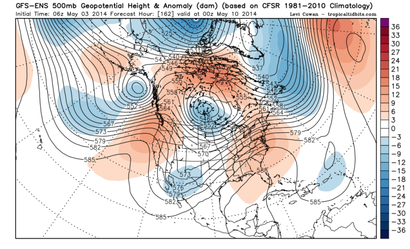
This will be the storm (blue shade west of El Paso, Tx) responsible for the possible beneficial rains late next week until the weekend. 6zGFS Ensembles is a bit stronger while the 0zECMWF Ensembles are a bit weaker and quicker with the storm. ECMWF Ensemble Means are still pretty wet tho, large area of Texas with 1.5''+ of Rain thru Sunday Morning.

Image
0 likes   
The following post is NOT an official forecast and should not be used as such. It is just the opinion of the poster and may or may not be backed by sound meteorological data. It is NOT endorsed by any professional institution including storm2k.org For Official Information please refer to the NHC and NWS products.

User avatar
Ntxw
Storm2k Moderator
Storm2k Moderator
Posts: 22785
Joined: Wed Oct 21, 2009 6:34 pm
Location: DFW, Texas

#672 Postby Ntxw » Sat May 03, 2014 11:16 am

We have to watch the EPAC if Amanda forms. This is highly unusual this time of year but the large envelope of moisture from any potential systems bears watch to help our little system out. The trough will draw it (moisture plume) out from the gulf of tehuantepec.
0 likes   
The above post and any post by Ntxw is NOT an official forecast and should not be used as such. It is just the opinion of the poster and may or may not be backed by sound meteorological data. It is NOT endorsed by any professional institution including Storm2k. For official information, please refer to NWS products.


  Help support Storm2K!

Help Support Storm2K


User avatar
Ntxw
Storm2k Moderator
Storm2k Moderator
Posts: 22785
Joined: Wed Oct 21, 2009 6:34 pm
Location: DFW, Texas

#673 Postby Ntxw » Sat May 03, 2014 11:18 pm

Could this be the coming party of El Nino? EPAC sure seems to think it as lot of incoming moisture will be from this region. I'm starting to see hints of parking troughs just to our west, SW flow with a Pacific Ocean about as wet as it can be bodes well. Will the skies open up and answer our prayers in deluge as it did in May of 1997? of course we got Jarrell out of it, costly price.

Image

The boy is coming fellow Texans and it cannot be stopped

Image

Image
0 likes   
The above post and any post by Ntxw is NOT an official forecast and should not be used as such. It is just the opinion of the poster and may or may not be backed by sound meteorological data. It is NOT endorsed by any professional institution including Storm2k. For official information, please refer to NWS products.


  Help support Storm2K!

Help Support Storm2K


weatherdude1108
Category 5
Category 5
Posts: 4228
Joined: Tue Dec 13, 2011 1:04 pm
Location: Northwest Austin/Cedar Park, TX

Re:

#674 Postby weatherdude1108 » Sat May 03, 2014 11:26 pm

Ntxw wrote:Could this be the coming party of El Nino? EPAC sure seems to think it as lot of incoming moisture will be from this region. I'm starting to see hints of parking troughs just to our west, SW flow with a Pacific Ocean about as wet as it can be bodes well. Will the skies open up and answer our prayers in deluge as it did in May of 1997? of course we got Jarrell out of it, costly price.

Image

The boy is coming fellow Texans and it cannot be stopped

Image

Image


That is a beautiful map!! :) Heaviest rain where most is needed. I have cracks all over my yard resulting from the humidity in the teens and 20 percent desert air ranges since last Monday.
0 likes   

User avatar
dhweather
S2K Supporter
S2K Supporter
Posts: 6199
Joined: Sat Aug 14, 2004 9:29 pm
Location: Heath, TX
Contact:

#675 Postby dhweather » Sun May 04, 2014 1:48 pm

I hope that precip map is right, lord knows we need it. Just drove over Ray Hubbard, it's looking mighty sad.

The Euro is rather bullish with rain thru 10 days, maybe it happens?
0 likes   
The above post and any post by dhweather is NOT an official forecast and should not be used as such. It is just the opinion of the poster and may or may not be backed by sound meteorological data. It is NOT endorsed by any professional institution including storm2k.org. For official information, please refer to NWS products.

User avatar
gboudx
S2K Supporter
S2K Supporter
Posts: 4080
Joined: Thu Sep 04, 2003 1:39 pm
Location: Rockwall, Tx but from Harvey, La

#676 Postby gboudx » Sun May 04, 2014 2:53 pm

:uarrow: I walked down to the "lake" yesterday. If I wanted to, I could walk straight across to Wylie and not get wet. But I'm a mile from the Collin/Rockwall county border so this is the far northern end of the lake.
0 likes   

User avatar
ravyrn
S2K Supporter
S2K Supporter
Posts: 1000
Age: 42
Joined: Sun Aug 31, 2008 5:10 am
Location: Alderbranch, TX

Re:

#677 Postby ravyrn » Mon May 05, 2014 12:20 am

Ntxw wrote:Could this be the coming party of El Nino? EPAC sure seems to think it as lot of incoming moisture will be from this region. I'm starting to see hints of parking troughs just to our west, SW flow with a Pacific Ocean about as wet as it can be bodes well. Will the skies open up and answer our prayers in deluge as it did in May of 1997? of course we got Jarrell out of it, costly price.

http://i60.tinypic.com/1r3mlv.gif

The boy is coming fellow Texans and it cannot be stopped

http://i62.tinypic.com/voxsgl.gif

http://i60.tinypic.com/1zmc8qa.jpg


I hope you're right, Ntxw. Unfortunately, a lot of the promets are on the hot/dry summer bus. I know there have been a few, but the only one I can think of off the top of my head is Steve McCauley. Their argument is that the effects of El Nino isn't generally felt in Texas during the summer, but later in the fall/winter. I'm not disagreeing with your assessment, I respect your analysis of the ENSO greatly. Just throwing out the POV from the opposition to us having a wet/mild summer. I do hope we get some rain in CTX and NTX to fill up those reservoirs. And also up in the panhandle to knock out that extreme drought -- tons of crops up that way. We're pretty fortunate here in ETX. Was fishing on Lake Palestine today and it is quite full and everything around us is relatively green. I hope that capacity and green can spread SW, W, NW, and NNW of me!
0 likes   

User avatar
Ntxw
Storm2k Moderator
Storm2k Moderator
Posts: 22785
Joined: Wed Oct 21, 2009 6:34 pm
Location: DFW, Texas

#678 Postby Ntxw » Mon May 05, 2014 7:10 am

:uarrow: I know what you mean, I feel the drought as much as the others around here. It's the safe forecast for a forecaster to continue what is, that I also understand. I try to avoid looking things in a regional scale which is what most do and works for short to medium term. Sometimes though you have to look out bigger, on global scale to grasp the long term.

DFW hit 96 yesterday which made the euro the superior model in forecasting the well above normal wave of heat ahead of the incoming trough over the GFS
0 likes   
The above post and any post by Ntxw is NOT an official forecast and should not be used as such. It is just the opinion of the poster and may or may not be backed by sound meteorological data. It is NOT endorsed by any professional institution including Storm2k. For official information, please refer to NWS products.


  Help support Storm2K!

Help Support Storm2K


User avatar
Texas Snowman
Storm2k Moderator
Storm2k Moderator
Posts: 6179
Joined: Fri Jan 25, 2008 11:29 am
Location: Denison, Texas

#679 Postby Texas Snowman » Mon May 05, 2014 8:38 am

@BigJoeBastardi · http://Weatherbell.com believes drought situation will be dented on plains this summer. CFSV2 next 45 days


**** CFSV2 picture Joe Bastardi posted on Twitter: https://pbs.twimg.com/media/Bm3y4QKCYAEbY1X.jpg:large
0 likes   
The above post and any post by Texas Snowman is NOT an official forecast and should not be used as such. It is just the opinion of the poster and may or may not be backed by sound meteorological data. It is NOT endorsed by any professional institution including storm2k.org. For official information, please refer to NWS products.

User avatar
dhweather
S2K Supporter
S2K Supporter
Posts: 6199
Joined: Sat Aug 14, 2004 9:29 pm
Location: Heath, TX
Contact:

#680 Postby dhweather » Mon May 05, 2014 9:08 am

0Z Euro isn't nearly as aggressive with rain as it was yesterday. We still get rain, just not a lot, maybe 1-1.5 inches.
0 likes   
The above post and any post by dhweather is NOT an official forecast and should not be used as such. It is just the opinion of the poster and may or may not be backed by sound meteorological data. It is NOT endorsed by any professional institution including storm2k.org. For official information, please refer to NWS products.


Return to “USA & Caribbean Weather”

Who is online

Users browsing this forum: No registered users and 7 guests