ENSO Updates (2007 thru 2023)
Moderator: S2k Moderators
Forum rules

The posts in this forum are NOT official forecasts and should not be used as such. They are just the opinion of the poster and may or may not be backed by sound meteorological data. They are NOT endorsed by any professional institution or STORM2K. For official information, please refer to products from the National Hurricane Center and National Weather Service.
-
xtyphooncyclonex

- Category 5

- Posts: 3891
- Age: 24
- Joined: Sat Dec 08, 2012 9:07 am
- Location: Cebu City
- Contact:
Some +1ºC anomalies are appearing and are spreading over the equatorial central and eastern Pacific.
0 likes
REMINDER: My opinions that I, or any other NON Pro-Met in this forum, are unofficial. Please do not take my opinions as an official forecast and warning. I am NOT a meteorologist. Following my forecasts blindly may lead to false alarm, danger and risk if official forecasts from agencies are ignored.


Cool maps of the day!
Ocean currents. It appears the equatorial Pacific has completely changed it's flow from typical. West to east is the new norm, new kelvin wave is pushing it's way from the west while the east continues to see rise in temperature anomalies as well as sea surface heights.

Latest animation of sst anom's the past week or so
http://www.esrl.noaa.gov/psd/map/clim/sst.anom.anim.week.html
Ocean currents. It appears the equatorial Pacific has completely changed it's flow from typical. West to east is the new norm, new kelvin wave is pushing it's way from the west while the east continues to see rise in temperature anomalies as well as sea surface heights.
Latest animation of sst anom's the past week or so
http://www.esrl.noaa.gov/psd/map/clim/sst.anom.anim.week.html
0 likes
The above post and any post by Ntxw is NOT an official forecast and should not be used as such. It is just the opinion of the poster and may or may not be backed by sound meteorological data. It is NOT endorsed by any professional institution including Storm2k. For official information, please refer to NWS products.
Help support Storm2K!
-
cycloneye

- Admin

- Posts: 149457
- Age: 69
- Joined: Thu Oct 10, 2002 10:54 am
- Location: San Juan, Puerto Rico
Re: ENSO Updates
Climate Prediction Center Monthly 5/8/14 update
CPC has a 65% of having El Nino by the summer.The big question continues to be how strong El Nino will be when it peaks.
EL NIÑO/SOUTHERN OSCILLATION (ENSO)
DIAGNOSTIC DISCUSSION
issued by
CLIMATE PREDICTION CENTER/NCEP
and the International Research Institute for Climate and Society
8 May 2014
ENSO Alert System Status: El Niño Watch
Synopsis: Chance of El Niño increases during the remainder of the year, exceeding 65% during summer.
ENSO-neutral continued during April 2014, but with above-average sea surface temperatures (SST) developing over much of the eastern tropical Pacific as well as persisting near the International Date Line (Fig. 1). The weekly SST indices were near to slightly above average and increasing in the Niño1+2, Niño3 and Niño3.4 regions, and above average in the Niño4 region (Fig. 2). The downwelling phase of a strong oceanic Kelvin wave that began in January greatly increased the oceanic heat content during March and April (Fig. 3), and produced large positive subsurface temperature anomalies across the central and eastern Pacific (Fig. 4). The upper portion of these subsurface anomalies reached the sea surface, warming the waters east of 125oW longitude. Also during April, weak low-level westerly wind anomalies were observed over the far western Pacific, while upper-level easterly anomalies occurred over much of the Pacific. Convection was enhanced over the west-central equatorial Pacific (Fig. 5). These atmospheric and oceanic conditions collectively indicate a continued evolution toward El Niño.
The model predictions of ENSO for this summer and beyond are indicating an increased likelihood of El Niño compared with those from last month. Most of the models indicate that ENSO-neutral (Niño-3.4 index between -0.5oC and 0.5oC) will persist through part of the remainder of the Northern Hemisphere spring 2014 (Fig. 6), most likely transitioning to El Niño during the summer. There remains uncertainty as to exactly when El Niño will develop and an even greater uncertainty as to how strong it may become. This uncertainty is related to the inherently lower forecast skill of the models for forecasts made in the spring. While ENSO-neutral is favored for Northern Hemisphere spring, the chance of El Niño increases during the remainder of the year, exceeding 65% during the summer (click CPC/IRI consensus forecast for the chance of each outcome).
http://www.cpc.ncep.noaa.gov/products/a ... odisc.html
0 likes
Visit the Caribbean-Central America Weather Thread where you can find at first post web cams,radars
and observations from Caribbean basin members Click Here
and observations from Caribbean basin members Click Here
First +1C anomaly area is appearing on the buoys, in regions 4 and western 3.4. Harbinger of things to come?

0 likes
The above post and any post by Ntxw is NOT an official forecast and should not be used as such. It is just the opinion of the poster and may or may not be backed by sound meteorological data. It is NOT endorsed by any professional institution including Storm2k. For official information, please refer to NWS products.
Help support Storm2K!
Help support Storm2K!
-
xtyphooncyclonex
- Category 5
- Posts: 3891
- Age: 24
- Joined: Sat Dec 08, 2012 9:07 am
- Location: Cebu City
- Contact:
Is there a chance that the El Niño will be declared by late May? My guess is also that we get our first 0.5C anomaly by the next update.
Current average SST anomaly temp estimate is at 0.75ºC
Current average SST anomaly temp estimate is at 0.75ºC
0 likes
REMINDER: My opinions that I, or any other NON Pro-Met in this forum, are unofficial. Please do not take my opinions as an official forecast and warning. I am NOT a meteorologist. Following my forecasts blindly may lead to false alarm, danger and risk if official forecasts from agencies are ignored.
-
xtyphooncyclonex
- Category 5
- Posts: 3891
- Age: 24
- Joined: Sat Dec 08, 2012 9:07 am
- Location: Cebu City
- Contact:
Over 50% chance of El Niño by MJJ. It is very likely that this year will not be a bust like 2012.
0 likes
REMINDER: My opinions that I, or any other NON Pro-Met in this forum, are unofficial. Please do not take my opinions as an official forecast and warning. I am NOT a meteorologist. Following my forecasts blindly may lead to false alarm, danger and risk if official forecasts from agencies are ignored.
Re:
xtyphooncyclonex wrote:Over 50% chance of El Niño by MJJ. It is very likely that this year will not be a bust like 2012.
April had an average above 0C likely somewhere between 0.2C or 0.3C. By the end of May if we see +1C and steadily rise in June, the average for the 3 months (AMJ) could still turn out as the first. If we wait until mid June or so to reach +1C the three month average would likely wait until MJJ. We won't know this until those months are all accounted for and gone by.
0 likes
The above post and any post by Ntxw is NOT an official forecast and should not be used as such. It is just the opinion of the poster and may or may not be backed by sound meteorological data. It is NOT endorsed by any professional institution including Storm2k. For official information, please refer to NWS products.
Help support Storm2K!
Help support Storm2K!
-
xtyphooncyclonex
- Category 5
- Posts: 3891
- Age: 24
- Joined: Sat Dec 08, 2012 9:07 am
- Location: Cebu City
- Contact:
Re: Re:
Ntxw wrote:xtyphooncyclonex wrote:Over 50% chance of El Niño by MJJ. It is very likely that this year will not be a bust like 2012.
April had an average above 0C likely somewhere between 0.2C or 0.3C. By the end of May if we see +1C and steadily rise in June, the average for the 3 months (AMJ) could still turn out as the first. If we wait until mid June or so to reach +1C the three month average would likely wait until MJJ. We won't know this until those months are all accounted for and gone by.
Well right now, the SST anomalies are rapidly increasing thanks to the surfacing of the warm pool. 2009 had the first 0.5 ONI by MJJ. Probably our first could be as what you said, AMJ. Could this be even stronger than 2009?
0 likes
REMINDER: My opinions that I, or any other NON Pro-Met in this forum, are unofficial. Please do not take my opinions as an official forecast and warning. I am NOT a meteorologist. Following my forecasts blindly may lead to false alarm, danger and risk if official forecasts from agencies are ignored.
Re: Re:
xtyphooncyclonex wrote:Well right now, the SST anomalies are rapidly increasing thanks to the surfacing of the warm pool. 2009 had the first 0.5 ONI by MJJ. Probably our first could be as what you said, AMJ. Could this be even stronger than 2009?
It most likely will match 09 and possibly stronger. However that Nino behaved differently and arguably is a different kind of Nino. It began MJJ but 0.5C weekly didn't come until Mid June and July is what brought the three months over 0.5C average. As mentioned before sea level rises, PDO, currents, westerlies, and most of the other Nino indexes we use were considerably lower in 09 and was not really prevalent as it is now until the fall for that year.
0 likes
The above post and any post by Ntxw is NOT an official forecast and should not be used as such. It is just the opinion of the poster and may or may not be backed by sound meteorological data. It is NOT endorsed by any professional institution including Storm2k. For official information, please refer to NWS products.
Help support Storm2K!
Help support Storm2K!
-
xtyphooncyclonex
- Category 5
- Posts: 3891
- Age: 24
- Joined: Sat Dec 08, 2012 9:07 am
- Location: Cebu City
- Contact:
Re: Re:
Ntxw wrote:xtyphooncyclonex wrote:Well right now, the SST anomalies are rapidly increasing thanks to the surfacing of the warm pool. 2009 had the first 0.5 ONI by MJJ. Probably our first could be as what you said, AMJ. Could this be even stronger than 2009?
It most likely will match 09 and possibly stronger. However that Nino behaved differently and arguably is a different kind of Nino. It began MJJ but 0.5C weekly didn't come until Mid June and July is what brought the three months over 0.5C average. As mentioned before sea level rises, PDO, currents, westerlies, and most of the other Nino indexes we use were considerably lower in 09 and was not really prevalent as it is now until the fall for that year.
Our first 0.5 is very likely on the second Monday of May! Niño 3.4 has been steady at borderline 0.5 and could be higher as CPC usually gives a higher rating. We could see also our first 1.0 in Niño 1+2!
0 likes
REMINDER: My opinions that I, or any other NON Pro-Met in this forum, are unofficial. Please do not take my opinions as an official forecast and warning. I am NOT a meteorologist. Following my forecasts blindly may lead to false alarm, danger and risk if official forecasts from agencies are ignored.


Re: ENSO: CPC May update=65% of El Nino by Summer
Not sure if it's been posted yet but the April PDO value was released at +1.13, up from +.97 in March.
0 likes
Re: ENSO: CPC May update=65% of El Nino by Summer
Siker wrote:Not sure if it's been posted yet but the April PDO value was released at +1.13, up from +.97 in March.
4th consecutive month and May has not deviated, it's not a fluke. Here's an interesting factoid; since 1950 we haven't seen a PDO value of greater than 1 in a cold PDO era. Whenever it did happen it was only towards the transition from cold to warm periods (1957, 1976, 2002) the PDO then remained positive for several years.
0 likes
The above post and any post by Ntxw is NOT an official forecast and should not be used as such. It is just the opinion of the poster and may or may not be backed by sound meteorological data. It is NOT endorsed by any professional institution including Storm2k. For official information, please refer to NWS products.
Help support Storm2K!
Help support Storm2K!
-
Yellow Evan

- Professional-Met

- Posts: 16240
- Age: 27
- Joined: Fri Jul 15, 2011 12:48 pm
- Location: Henderson, Nevada/Honolulu, HI
- Contact:
Re: ENSO: CPC May update=65% of El Nino by Summer
Ntxw wrote:Siker wrote:Not sure if it's been posted yet but the April PDO value was released at +1.13, up from +.97 in March.
4th consecutive month and May has not deviated, it's not a fluke. Here's an interesting factoid; since 1950 we haven't seen a PDO value of greater than 1 in a cold PDO era. Whenever it did happen it was only towards the transition from cold to warm periods (1957, 1976, 2002) the PDO then remained positive for several years.
Wait, PDO was positive prior to 1957? 2002-2006 was kinda an upward spike within a cold PDO era, so I guess that was a transition from cold to warm.
0 likes
Re: ENSO: CPC May update=65% of El Nino by Summer
Yellow Evan wrote:Ntxw wrote:Siker wrote:Not sure if it's been posted yet but the April PDO value was released at +1.13, up from +.97 in March.
4th consecutive month and May has not deviated, it's not a fluke. Here's an interesting factoid; since 1950 we haven't seen a PDO value of greater than 1 in a cold PDO era. Whenever it did happen it was only towards the transition from cold to warm periods (1957, 1976, 2002) the PDO then remained positive for several years.
Wait, PDO was positive prior to 1957? 2002-2006 was kinda an upward spike within a cold PDO era, so I guess that was a transition from cold to warm.
1957's El Nino ended the long streak of negative PDO of the 40s/50s. It was not too different from 2002 in that it was a respite between negative PDO and extended a few years. They weren't long lasting like 1980s/1990s +PDO but I guess it comes down to your definition of a -PDO/+PDO whether it is a prolonged break or a shorter positive era. Negative PDO era El Nino's don't produce the big +PDO readings. As powerful as 1972 and 2009 was they only brought the index up to weak levels for only a few months.
So now begs the question, is this another break? A new era? Or just an unusual blip for the Nino and dies, if it continues. A few readings doesn't mean much in the big scheme over years but if it continues it's a good question to ask with some eyebrow raising values.
0 likes
The above post and any post by Ntxw is NOT an official forecast and should not be used as such. It is just the opinion of the poster and may or may not be backed by sound meteorological data. It is NOT endorsed by any professional institution including Storm2k. For official information, please refer to NWS products.
Help support Storm2K!
Help support Storm2K!
-
xtyphooncyclonex
- Category 5
- Posts: 3891
- Age: 24
- Joined: Sat Dec 08, 2012 9:07 am
- Location: Cebu City
- Contact:
Current Daily Niño values: (all rounded)
1+2: +1.0ºC
3: +0.7ºC
3.4: +0.5ºC
4: +1.0ºC
These are also my predictions for the CPC weekly update, this could also even be higher.
1+2: +1.0ºC
3: +0.7ºC
3.4: +0.5ºC
4: +1.0ºC
These are also my predictions for the CPC weekly update, this could also even be higher.
0 likes
REMINDER: My opinions that I, or any other NON Pro-Met in this forum, are unofficial. Please do not take my opinions as an official forecast and warning. I am NOT a meteorologist. Following my forecasts blindly may lead to false alarm, danger and risk if official forecasts from agencies are ignored.
-
Yellow Evan
- Professional-Met
- Posts: 16240
- Age: 27
- Joined: Fri Jul 15, 2011 12:48 pm
- Location: Henderson, Nevada/Honolulu, HI
- Contact:
Re: ENSO: CPC May update=65% of El Nino by Summer
Ntxw wrote:Yellow Evan wrote:Ntxw wrote:
4th consecutive month and May has not deviated, it's not a fluke. Here's an interesting factoid; since 1950 we haven't seen a PDO value of greater than 1 in a cold PDO era. Whenever it did happen it was only towards the transition from cold to warm periods (1957, 1976, 2002) the PDO then remained positive for several years.
Wait, PDO was positive prior to 1957? 2002-2006 was kinda an upward spike within a cold PDO era, so I guess that was a transition from cold to warm.
1957's El Nino ended the long streak of negative PDO of the 40s/50s. It was not too different from 2002 in that it was a respite between negative PDO and extended a few years. They weren't long lasting like 1980s/1990s +PDO but I guess it comes down to your definition of a -PDO/+PDO whether it is a prolonged break or a shorter positive era. Negative PDO era El Nino's don't produce the big +PDO readings. As powerful as 1972 and 2009 was they only brought the index up to weak levels for only a few months.
So now begs the question, is this another break? A new era? Or just an unusual blip for the Nino and dies, if it continues. A few readings doesn't mean much in the big scheme over years but if it continues it's a good question to ask with some eyebrow raising values.
I doubt it's a new era. I think it's just a blip like 1972 and 1965 were.
It's also worth noting that 3 El Ninos occurred form 1962-66, and fourth in 1968-69. 1957-58 and 1969-70 had briefly El Nino comebacks in 1959 and 1970 as well. Something just does not seem right with that, given that in the present -PDO era, we haven't had El Nino-neutral-El Nino kind of event.
0 likes
0 likes
The above post and any post by Ntxw is NOT an official forecast and should not be used as such. It is just the opinion of the poster and may or may not be backed by sound meteorological data. It is NOT endorsed by any professional institution including Storm2k. For official information, please refer to NWS products.
Help support Storm2K!
Help support Storm2K!

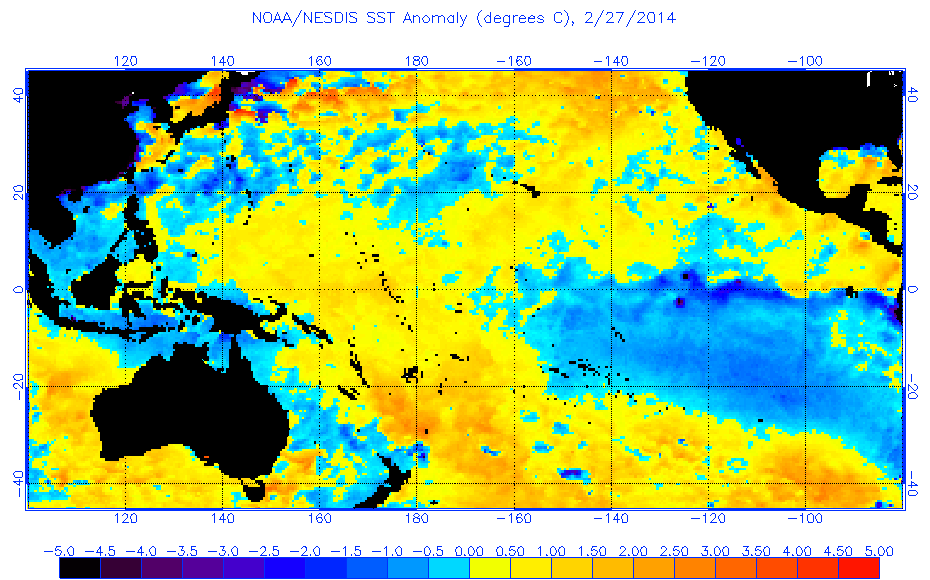
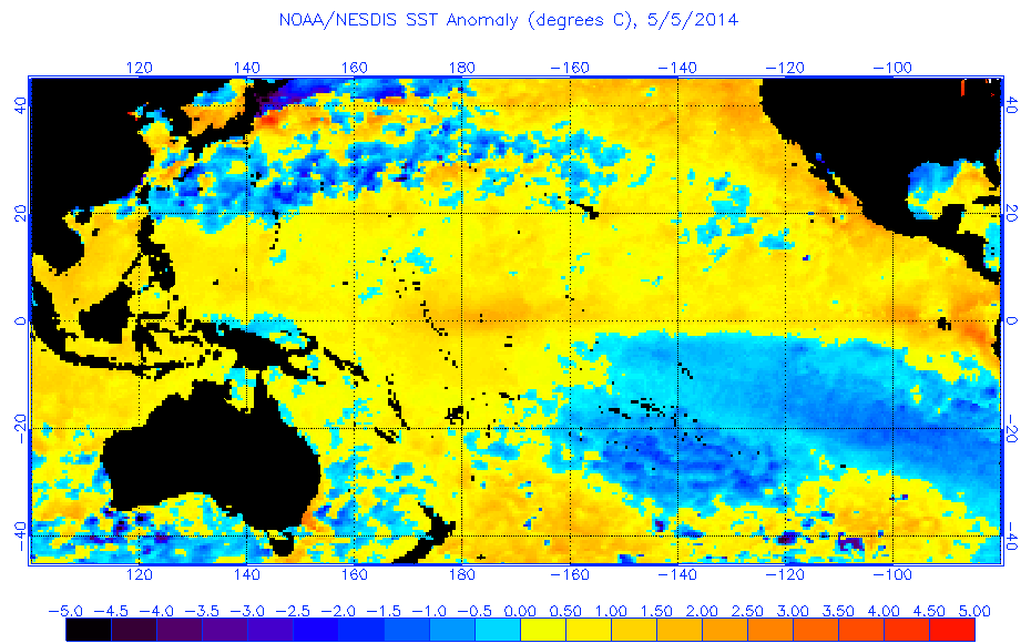
Re: ENSO Updates= April PDO data up to +1.13
interesting comparison, little over two months here and a 5C increase in some areas
http://www.ospo.noaa.gov/data/sst/anomaly/2014/anomp.2.27.2014.gif
http://www.ospo.noaa.gov/data/sst/anomaly/2014/anomp.5.5.2014.gif
http://www.ospo.noaa.gov/data/sst/anomaly/2014/anomp.2.27.2014.gif
http://www.ospo.noaa.gov/data/sst/anomaly/2014/anomp.5.5.2014.gif
0 likes
The above post is not official and should not be used as such. It is the opinion of the poster and may or may not be backed by sound meteorological data. It is not endorsed by any professional institution or storm2k.org. For official information, please refer to the NHC and NWS products.
-
xtyphooncyclonex
- Category 5
- Posts: 3891
- Age: 24
- Joined: Sat Dec 08, 2012 9:07 am
- Location: Cebu City
- Contact:
Niño 1+2 exceeds moderate El Niño threshold! Meanwhile Niño 3 and 3.4 are rapidly warming but still at weak threshold. Niño 4 just weakened from moderate. These are just daily unofficial anomalies posted in Tropical Tidbits.
Anyway, in this update all Niño regions should be at El Niño threshold.
Anyway, in this update all Niño regions should be at El Niño threshold.
0 likes
REMINDER: My opinions that I, or any other NON Pro-Met in this forum, are unofficial. Please do not take my opinions as an official forecast and warning. I am NOT a meteorologist. Following my forecasts blindly may lead to false alarm, danger and risk if official forecasts from agencies are ignored.
-
xtyphooncyclonex
- Category 5
- Posts: 3891
- Age: 24
- Joined: Sat Dec 08, 2012 9:07 am
- Location: Cebu City
- Contact:
30 day SOI is rapidly going down near negative but not yet at Niño threshold.
0 likes
REMINDER: My opinions that I, or any other NON Pro-Met in this forum, are unofficial. Please do not take my opinions as an official forecast and warning. I am NOT a meteorologist. Following my forecasts blindly may lead to false alarm, danger and risk if official forecasts from agencies are ignored.
Who is online
Users browsing this forum: TomballEd, WaveBreaking and 127 guests