
425
WFUS53 KICT 120227
TORICT
KSC113-159-120300-
/O.NEW.KICT.TO.W.0004.140512T0227Z-140512T0300Z/
BULLETIN - EAS ACTIVATION REQUESTED
TORNADO WARNING
NATIONAL WEATHER SERVICE WICHITA KS
927 PM CDT SUN MAY 11 2014
THE NATIONAL WEATHER SERVICE IN WICHITA HAS ISSUED A
* TORNADO WARNING FOR...
WESTERN MCPHERSON COUNTY IN CENTRAL KANSAS...
EASTERN RICE COUNTY IN CENTRAL KANSAS...
* UNTIL 1000 PM CDT
* AT 923 PM CDT...A CONFIRMED TORNADO WAS LOCATED 8 MILES NORTHEAST
OF NICKERSON...AND MOVING NORTHEAST AT 45 MPH.
HAZARD...DAMAGING TORNADO AND GOLF BALL SIZE HAIL.
SOURCE...WEATHER SPOTTERS CONFIRMED TORNADO.
IMPACT...FLYING DEBRIS WILL BE DANGEROUS TO THOSE CAUGHT WITHOUT
SHELTER. MOBILE HOMES WILL BE DAMAGED OR DESTROYED. DAMAGE
TO ROOFS...WINDOWS AND VEHICLES WILL OCCUR. TREE DAMAGE IS
LIKELY.
* THE TORNADO WILL BE NEAR...
WINDOM AND INMAN AROUND 935 PM CDT.
MCPHERSON AROUND 950 PM CDT.
OTHER LOCATIONS IN THE WARNING INCLUDE MCPHERSON AIRPORT.
THIS INCLUDES INTERSTATE 135 BETWEEN MILE MARKERS 51 AND 77.
PRECAUTIONARY/PREPAREDNESS ACTIONS...
TO REPEAT...A TORNADO IS ON THE GROUND. TAKE COVER NOW. MOVE TO AN
INTERIOR ROOM ON THE LOWEST FLOOR OF A STURDY BUILDING. AVOID
WINDOWS. IF IN A MOBILE HOME...A VEHICLE OR OUTDOORS...MOVE TO THE
CLOSEST SUBSTANTIAL SHELTER AND PROTECT YOURSELF FROM FLYING DEBRIS.
TORNADOES ARE DIFFICULT TO SEE AND CONFIRM AT NIGHT. TAKE COVER NOW.
Tornado Outbreak Possible 5/11/2014
Moderator: S2k Moderators
Forum rules

The posts in this forum are NOT official forecast and should not be used as such. They are just the opinion of the poster and may or may not be backed by sound meteorological data. They are NOT endorsed by any professional institution or STORM2K.
316
WFUS53 KICT 120257
TORICT
KSC113-120330-
/O.NEW.KICT.TO.W.0005.140512T0257Z-140512T0330Z/
BULLETIN - EAS ACTIVATION REQUESTED
TORNADO WARNING
NATIONAL WEATHER SERVICE WICHITA KS
957 PM CDT SUN MAY 11 2014
THE NATIONAL WEATHER SERVICE IN WICHITA HAS ISSUED A
* TORNADO WARNING FOR...
MCPHERSON COUNTY IN CENTRAL KANSAS...
* UNTIL 1030 PM CDT
* AT 956 PM CDT...A CONFIRMED TORNADO WAS LOCATED NEAR MCPHERSON...
AND MOVING NORTHEAST AT 30 MPH. THIS WARNING REPLACES THE PREVIOUS
TORNADO WARNING FOR MCPHERSON COUNTY.
HAZARD...DAMAGING TORNADO AND GOLF BALL SIZE HAIL.
SOURCE...EMERGENCY MANAGEMENT CONFIRMED TORNADO.
IMPACT...FLYING DEBRIS WILL BE DANGEROUS TO THOSE CAUGHT WITHOUT
SHELTER. MOBILE HOMES WILL BE DAMAGED OR DESTROYED. DAMAGE
TO ROOFS...WINDOWS AND VEHICLES WILL OCCUR. TREE DAMAGE IS
LIKELY.
* THE TORNADO WILL BE NEAR...
GALVA AROUND 1015 PM CDT.
CANTON AROUND 1025 PM CDT.
THIS INCLUDES INTERSTATE 135 BETWEEN MILE MARKERS 44 AND 69.
PRECAUTIONARY/PREPAREDNESS ACTIONS...
TO REPEAT...A TORNADO IS ON THE GROUND. TAKE COVER NOW. MOVE TO AN
INTERIOR ROOM ON THE LOWEST FLOOR OF A STURDY BUILDING. AVOID
WINDOWS. IF IN A MOBILE HOME...A VEHICLE OR OUTDOORS...MOVE TO THE
CLOSEST SUBSTANTIAL SHELTER AND PROTECT YOURSELF FROM FLYING DEBRIS.
TORNADOES ARE DIFFICULT TO SEE AND CONFIRM AT NIGHT. TAKE COVER NOW.
0 likes


Re: Tornado Outbreak Possible 5/11/2014

Photo allegedly taken in Johnston, IA last night. I can't find any reports of a tornado there? Maybe a funnel cloud?
0 likes
Re:
Bunkertor wrote:^ That would be a very well shaped funnel cloud....
I found the source of the photo on Twitter and confirmed the photo was from last night and from Johnston, as per a google image search.
No tornado reported near Johnston/Des Moines, so it must have been one heck of a funnel cloud.
0 likes

More amazing video
Cyclenall wrote:RL3AO wrote:Wheres that pic from because I'm skeptical its from today. There has been no reports of a large tornado.
I couldn't get a tag for it because its a screen grab but there have been 1 or 2 reports of a large tornado from this main supercell today, the NWS used the strong wording "A large and extremely dangerous tornado" in the TOR warning at one point.
The video where the still was taken from is on YouTube now:
[youtube]http://www.youtube.com/watch?v=6DDc3qlK4qg[/youtube]
0 likes
-
supercane4867
- Category 5

- Posts: 4966
- Joined: Wed Nov 14, 2012 10:43 am
Re: Tornado Outbreak Possible 5/11/2014
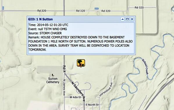
There was a report of house destroyed down to the basement in Sutton earlier, that sounds like at least EF4 damage
0 likes

-
TropicalAnalystwx13

- Category 5
- Posts: 2109
- Age: 28
- Joined: Tue Jul 19, 2011 8:20 pm
- Location: Wilmington, NC
- Contact:
Return to “USA & Caribbean Weather”
Who is online
Users browsing this forum: AnnularCane, HurricaneBelle and 63 guests