I guess this is only 5 knots shy of category 5 status, this is unbelievable.
EPAC: AMANDA - Post-Tropical
Moderator: S2k Moderators
-
xtyphooncyclonex

- Category 5

- Posts: 3891
- Age: 24
- Joined: Sat Dec 08, 2012 9:07 am
- Location: Cebu City
- Contact:
The strongest May ePac hurricane in recorded history, surpassing Hurricane Adolph of 2001. 
I guess this is only 5 knots shy of category 5 status, this is unbelievable.
I guess this is only 5 knots shy of category 5 status, this is unbelievable.
0 likes
REMINDER: My opinions that I, or any other NON Pro-Met in this forum, are unofficial. Please do not take my opinions as an official forecast and warning. I am NOT a meteorologist. Following my forecasts blindly may lead to false alarm, danger and risk if official forecasts from agencies are ignored.
-
Yellow Evan

- Professional-Met

- Posts: 16240
- Age: 27
- Joined: Fri Jul 15, 2011 12:48 pm
- Location: Henderson, Nevada/Honolulu, HI
- Contact:
-
Yellow Evan
- Professional-Met
- Posts: 16240
- Age: 27
- Joined: Fri Jul 15, 2011 12:48 pm
- Location: Henderson, Nevada/Honolulu, HI
- Contact:
Re: Re:
Extratropical94 wrote:RL3AO wrote:Its really hard for NHC to go 140 without recon. If we get some more dark grey on the dvorak IR images, they might do it.
Do you know if they had recon in Celia (2010)?
No. Celia was way too far out and land, and the NHC focused it's recon on what later became Alex 10 in the ATL.
0 likes
-
hurricanes1234
- Category 5
- Posts: 2908
- Joined: Sat Jul 28, 2012 6:19 pm
- Location: Trinidad and Tobago
Re:
Yellow Evan wrote:HOLY CRAP!!!!! WOW!!!!!!!!
I can not believe this. This is stunning. WOW!!!! Never though in my wildest dreams this would happen. 135 KNOTS in may!!!
Yes, indeed. I don't think anyone thought this would happen. Now it's just to wait a little less than two hours before history is likely made.
0 likes
PLEASE NOTE: With the exception of information from weather agencies that I may copy and paste here, my posts will NEVER be official, since I am NOT a meteorologist. They are solely my amateur opinion, and may or may not be accurate. Therefore, please DO NOT use them as official details, particularly when making important decisions. Thank you.
-
xtyphooncyclonex
- Category 5
- Posts: 3891
- Age: 24
- Joined: Sat Dec 08, 2012 9:07 am
- Location: Cebu City
- Contact:
Hurricane Amanda is currently the strongest storm in the ePac since Hurricane Celia of 2010.
Could this be stronger? I am really amazed.
Could this be stronger? I am really amazed.
0 likes
REMINDER: My opinions that I, or any other NON Pro-Met in this forum, are unofficial. Please do not take my opinions as an official forecast and warning. I am NOT a meteorologist. Following my forecasts blindly may lead to false alarm, danger and risk if official forecasts from agencies are ignored.
-
TheAustinMan

- Category 5
- Posts: 1060
- Joined: Mon Jul 08, 2013 4:26 pm
- Location: Central TX / United States
Re:
xtyphooncyclonex wrote:Hurricane Amanda is currently the strongest storm in the ePac since Hurricane Celia of 2010.
Could this be stronger? I am really amazed.
Just a little correction - Hurricane Dora (2011) did make it as strong as 155 mph / 929 mbar in July.
0 likes
Treat my opinions with a grain of salt. For official information see your local weather service.
“It's tough to make predictions, especially about the future.”
“It's tough to make predictions, especially about the future.”

Re: EPAC: AMANDA - Hurricane=12z Best Track up to 135kts.
Last time we saw such a stunning storm on this side of the world was Dora in 2011.

0 likes
-
Yellow Evan
- Professional-Met
- Posts: 16240
- Age: 27
- Joined: Fri Jul 15, 2011 12:48 pm
- Location: Henderson, Nevada/Honolulu, HI
- Contact:
Re:
xtyphooncyclonex wrote:Hurricane Amanda is currently the strongest storm in the ePac since Hurricane Celia of 2010.
Could this be stronger? I am really amazed.
They might pull the trigger IMO. Steward did the 12z TWO, and he tends to be very bullish.
0 likes
-
xtyphooncyclonex
- Category 5
- Posts: 3891
- Age: 24
- Joined: Sat Dec 08, 2012 9:07 am
- Location: Cebu City
- Contact:
Re: Re:
Yellow Evan wrote:xtyphooncyclonex wrote:Hurricane Amanda is currently the strongest storm in the ePac since Hurricane Celia of 2010.
Could this be stronger? I am really amazed.
They might pull the trigger IMO. Steward did the 12z TWO, and he tends to be very bullish.
But still, the convection is really cold and the eye is so warm. The storm looks impressive enough for that intensity. The last time we had this was Dora of 2011. This is quite unusual, as it is very early for such to form.
0 likes
REMINDER: My opinions that I, or any other NON Pro-Met in this forum, are unofficial. Please do not take my opinions as an official forecast and warning. I am NOT a meteorologist. Following my forecasts blindly may lead to false alarm, danger and risk if official forecasts from agencies are ignored.


Holy cow is right. She continues to beat what you think she will do. Just stunning little system, record making.
0 likes
The above post and any post by Ntxw is NOT an official forecast and should not be used as such. It is just the opinion of the poster and may or may not be backed by sound meteorological data. It is NOT endorsed by any professional institution including Storm2k. For official information, please refer to NWS products.
Help support Storm2K!

-
TheAustinMan
- Category 5
- Posts: 1060
- Joined: Mon Jul 08, 2013 4:26 pm
- Location: Central TX / United States
Re: EPAC: AMANDA - Hurricane=12z Best Track up to 135kts.
Latest microwave imagery does not show any signs of an EWRC as of yet, and unlike Hurricane Dora of 2011, Amanda does not appear to have a dominant peripheral mass of convection. As the terminator approaches Amanda we should get to finally see what Amanda looks like in its sharpest definition.

Last edited by TheAustinMan on Sun May 25, 2014 8:47 am, edited 1 time in total.
0 likes
Treat my opinions with a grain of salt. For official information see your local weather service.
“It's tough to make predictions, especially about the future.”
“It's tough to make predictions, especially about the future.”
-
hurricanes1234
- Category 5
- Posts: 2908
- Joined: Sat Jul 28, 2012 6:19 pm
- Location: Trinidad and Tobago
Re: EPAC: AMANDA - Hurricane=12z Best Track up to 135kts.
I've run out of words for this hurricane.


0 likes
PLEASE NOTE: With the exception of information from weather agencies that I may copy and paste here, my posts will NEVER be official, since I am NOT a meteorologist. They are solely my amateur opinion, and may or may not be accurate. Therefore, please DO NOT use them as official details, particularly when making important decisions. Thank you.
-
Yellow Evan
- Professional-Met
- Posts: 16240
- Age: 27
- Joined: Fri Jul 15, 2011 12:48 pm
- Location: Henderson, Nevada/Honolulu, HI
- Contact:
-
Tireman4

- S2K Supporter

- Posts: 5903
- Age: 60
- Joined: Fri Jun 30, 2006 1:08 pm
- Location: Humble, Texas
- Contact:
Re:
Ntxw wrote:Holy cow is right. She continues to beat what you think she will do. Just stunning little system, record making.
I hope I am not stating the obvious, but this could be a long year in the EPAC....
0 likes
-
cycloneye

- Admin

- Posts: 149505
- Age: 69
- Joined: Thu Oct 10, 2002 10:54 am
- Location: San Juan, Puerto Rico
Re: Re:
Tireman4 wrote:Ntxw wrote:Holy cow is right. She continues to beat what you think she will do. Just stunning little system, record making.
I hope I am not stating the obvious, but this could be a long year in the EPAC....
I posted something like that at EPAC thread
0 likes
Visit the Caribbean-Central America Weather Thread where you can find at first post web cams,radars
and observations from Caribbean basin members Click Here
and observations from Caribbean basin members Click Here
-
hurricanes1234
- Category 5
- Posts: 2908
- Joined: Sat Jul 28, 2012 6:19 pm
- Location: Trinidad and Tobago
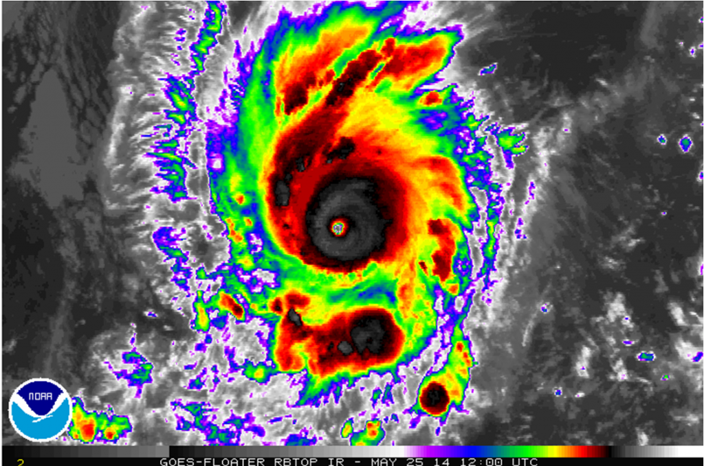
The cloudtops have warmed a little, but the ring of red is even thicker and rounder, plus, the eye looks clearer to me. I, however, don't fully think they'll upgrade it to a Category 5, but that's just my opinion.
0 likes
PLEASE NOTE: With the exception of information from weather agencies that I may copy and paste here, my posts will NEVER be official, since I am NOT a meteorologist. They are solely my amateur opinion, and may or may not be accurate. Therefore, please DO NOT use them as official details, particularly when making important decisions. Thank you.
-
Yellow Evan
- Professional-Met
- Posts: 16240
- Age: 27
- Joined: Fri Jul 15, 2011 12:48 pm
- Location: Henderson, Nevada/Honolulu, HI
- Contact:
Re:
hurricanes1234 wrote:The cloudtops have warmed a little, but the ring of red is even thicker and rounder, plus, the eye looks clearer to me. I, however, don't fully think they'll upgrade it to a Category 5, but that's just my opinion.
I won't be shocked if they keep it at 135 knts, but I think there's chance they declare it 140 knts.
0 likes
-
tolakram
- Admin
- Posts: 20186
- Age: 62
- Joined: Sun Aug 27, 2006 8:23 pm
- Location: Florence, KY (name is Mark)
Re: EPAC: AMANDA - Hurricane
Still a little early for a good visible but you can see what appears to be shear starting to impinge on the right side of Amanda.
13:00Z

13:00Z

0 likes
M a r k
- - - - -
Join us in chat: Storm2K Chatroom Invite. Android and IOS apps also available.
The posts in this forum are NOT official forecasts and should not be used as such. Posts are NOT endorsed by any professional institution or STORM2K.org. For official information and forecasts, please refer to NHC and NWS products.
Re: Re:
Yellow Evan wrote:hurricanes1234 wrote:The cloudtops have warmed a little, but the ring of red is even thicker and rounder, plus, the eye looks clearer to me. I, however, don't fully think they'll upgrade it to a Category 5, but that's just my opinion.
I won't be shocked if they keep it at 135 knts, but I think there's chance they declare it 140 knts.
Wouldn't this make Amanda very close (if not soon) to tie or beating ITA for the strongest cyclone in 2014 to date? ITA peaked at 135kts and 930mbar
0 likes
The above post and any post by Ntxw is NOT an official forecast and should not be used as such. It is just the opinion of the poster and may or may not be backed by sound meteorological data. It is NOT endorsed by any professional institution including Storm2k. For official information, please refer to NWS products.
Help support Storm2K!
Help support Storm2K!
-
hurricanes1234
- Category 5
- Posts: 2908
- Joined: Sat Jul 28, 2012 6:19 pm
- Location: Trinidad and Tobago
First visible - SPECTACULAR.

IMPORTANT: This file may not be downloadable on all devices. It is a GIF file.
IMPORTANT: This file may not be downloadable on all devices. It is a GIF file.
0 likes
PLEASE NOTE: With the exception of information from weather agencies that I may copy and paste here, my posts will NEVER be official, since I am NOT a meteorologist. They are solely my amateur opinion, and may or may not be accurate. Therefore, please DO NOT use them as official details, particularly when making important decisions. Thank you.
Who is online
Users browsing this forum: No registered users and 32 guests