Texas Spring-2014
Moderator: S2k Moderators
Forum rules

The posts in this forum are NOT official forecast and should not be used as such. They are just the opinion of the poster and may or may not be backed by sound meteorological data. They are NOT endorsed by any professional institution or STORM2K.
-
Portastorm

- Storm2k Moderator

- Posts: 9955
- Age: 63
- Joined: Fri Jul 11, 2003 9:16 am
- Location: Round Rock, TX
- Contact:
Re: Texas Spring-2014
Recorded 1.85" of rain since midnight. That takes the two-day total close to 4 inches! I'm going to steal the McDonalds ad phrase and write: I'm Loving It! 
0 likes
Any forecasts under my name are to be taken with a grain of salt. Get your best forecasts from the National Weather Service and National Hurricane Center.
-
srainhoutx

- S2K Supporter

- Posts: 6919
- Age: 68
- Joined: Sun Jan 14, 2007 11:34 am
- Location: Haywood County, NC
- Contact:
Re: Texas Spring-2014
An additional 1.37 inches of rain in the gauge for a total of 5.62 inches since 4:00 PM yesterday at my location in NW Harris County.
0 likes
Carla/Alicia/Jerry(In The Eye)/Michelle/Charley/Ivan/Dennis/Katrina/Rita/Wilma/Ike/Harvey
Member: National Weather Association
Wx Infinity Forums
http://wxinfinity.com/index.php
Facebook.com/WeatherInfinity
Twitter @WeatherInfinity
Member: National Weather Association
Wx Infinity Forums
http://wxinfinity.com/index.php
Facebook.com/WeatherInfinity
Twitter @WeatherInfinity
-
Tireman4

- S2K Supporter
- Posts: 5903
- Age: 60
- Joined: Fri Jun 30, 2006 1:08 pm
- Location: Humble, Texas
- Contact:
Re: Texas Spring-2014
Portastorm wrote:Recorded 1.85" of rain since midnight. That takes the two-day total close to 4 inches! I'm going to steal the McDonalds ad phrase and write: I'm Loving It!
I thought it was "You deserve a break today"? LOL
0 likes
-
weatherdude1108
- Category 5

- Posts: 4228
- Joined: Tue Dec 13, 2011 1:04 pm
- Location: Northwest Austin/Cedar Park, TX
Nice to see the area lakes starting to respond to all of this.  We need a few more of these over the next week to make a dent. But, at least it's better than nothing.
Lake Buchanan is expected to rise to between 988 and 989 over the next 24 hours. Lake Travis is expected to rise to between 626 and 626.5 over the next 24 hours.
http://hydromet.lcra.org/riverreport/report.aspx
Lake Buchanan is expected to rise to between 988 and 989 over the next 24 hours. Lake Travis is expected to rise to between 626 and 626.5 over the next 24 hours.
http://hydromet.lcra.org/riverreport/report.aspx
0 likes
The preceding post is NOT an official forecast, and should not be used as such. It is only the opinion of the poster and may or may not be backed by sound meteorological data. It is NOT endorsed by any professional institution including storm2k.org. For Official Information please refer to the NHC and NWS products.
-
TeamPlayersBlue

- Category 5
- Posts: 3530
- Joined: Tue Feb 02, 2010 1:44 am
- Location: Denver/Applewood, CO
Another 1.12 inches here so far. Still some pitter patter outside. Have the windows open today and its almost June. Love it.
0 likes
Personal Forecast Disclaimer:
The posts in this forum are NOT official forecast and should not be used as such. They are just the opinion of the poster and may or may not be backed by sound meteorological data. They are NOT endorsed by any professional institution or storm2k.org. For official information, please refer to the NHC and NWS products.
The posts in this forum are NOT official forecast and should not be used as such. They are just the opinion of the poster and may or may not be backed by sound meteorological data. They are NOT endorsed by any professional institution or storm2k.org. For official information, please refer to the NHC and NWS products.

Re: Re:
gboudx wrote:TheProfessor wrote:This system is becoming a big disappointment for me, I was hoping for a few inches of rain but haven't gotten them yet.
It's not just you, but the DFW area. Today was supposed to be our big rain day so we'll just have to wait and see. We need the big rain area to the south to move further off to the east, because it's probably robbing us of inflow.
I think we are effectively getting dry slotted.
0 likes
The above post and any post by dhweather is NOT an official forecast and should not be used as such. It is just the opinion of the poster and may or may not be backed by sound meteorological data. It is NOT endorsed by any professional institution including storm2k.org. For official information, please refer to NWS products.
-
gboudx

- S2K Supporter
- Posts: 4090
- Joined: Thu Sep 04, 2003 1:39 pm
- Location: Rockwall, Tx but from Harvey, La
Re: Re:
dhweather wrote:gboudx wrote:TheProfessor wrote:This system is becoming a big disappointment for me, I was hoping for a few inches of rain but haven't gotten them yet.
It's not just you, but the DFW area. Today was supposed to be our big rain day so we'll just have to wait and see. We need the big rain area to the south to move further off to the east, because it's probably robbing us of inflow.
I think we are effectively getting dry slotted.
I want to see what happens out west with clearing occurring and instability increasing. Hopefully we start seeing storms develop and move our way. It would be nice to see an MCS develop and move slowly over us.
0 likes
-
TheProfessor

- Professional-Met

- Posts: 3506
- Age: 29
- Joined: Tue Dec 03, 2013 10:56 am
- Location: Wichita, Kansas
-
TeamPlayersBlue
- Category 5
- Posts: 3530
- Joined: Tue Feb 02, 2010 1:44 am
- Location: Denver/Applewood, CO
I havent seen dewpoints on the backside of the low but is it possible you guys can get the wrap around moisture? Another line is developing now which should hit SE texas later. Dont think were playing softball tomorrow night if we get another half inch or so 
0 likes
Personal Forecast Disclaimer:
The posts in this forum are NOT official forecast and should not be used as such. They are just the opinion of the poster and may or may not be backed by sound meteorological data. They are NOT endorsed by any professional institution or storm2k.org. For official information, please refer to the NHC and NWS products.
The posts in this forum are NOT official forecast and should not be used as such. They are just the opinion of the poster and may or may not be backed by sound meteorological data. They are NOT endorsed by any professional institution or storm2k.org. For official information, please refer to the NHC and NWS products.
-
TeamPlayersBlue
- Category 5
- Posts: 3530
- Joined: Tue Feb 02, 2010 1:44 am
- Location: Denver/Applewood, CO
http://www.ssd.noaa.gov/goes/east/wfo/t ... h-vis.html posted by Ryan Maue.... The Low basically has an eye
0 likes
Personal Forecast Disclaimer:
The posts in this forum are NOT official forecast and should not be used as such. They are just the opinion of the poster and may or may not be backed by sound meteorological data. They are NOT endorsed by any professional institution or storm2k.org. For official information, please refer to the NHC and NWS products.
The posts in this forum are NOT official forecast and should not be used as such. They are just the opinion of the poster and may or may not be backed by sound meteorological data. They are NOT endorsed by any professional institution or storm2k.org. For official information, please refer to the NHC and NWS products.
-
aggiecutter
- Category 5
- Posts: 1755
- Joined: Thu Oct 14, 2004 9:22 pm
- Location: Texarkana
Re: Texas Spring-2014
Looks like some heavy convection starting to fire a long the core of the low as it enters north Texas:
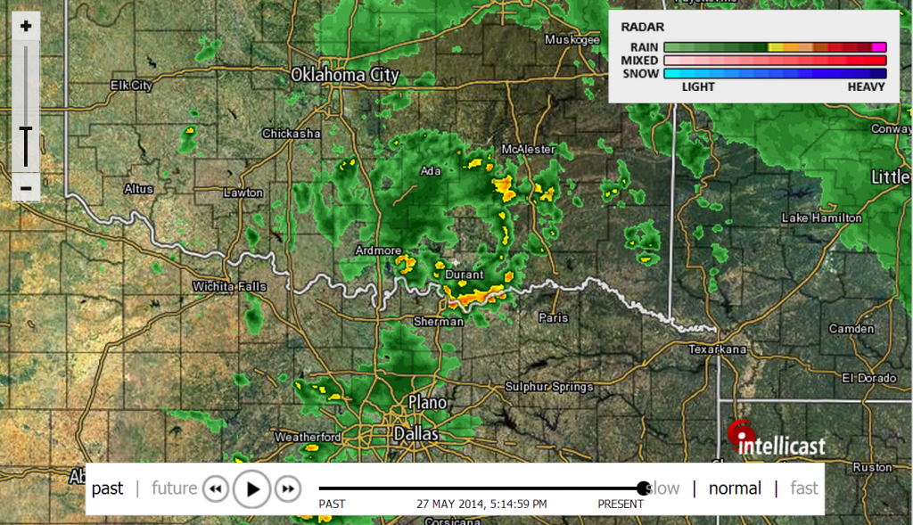

0 likes
-
aggiecutter
- Category 5
- Posts: 1755
- Joined: Thu Oct 14, 2004 9:22 pm
- Location: Texarkana
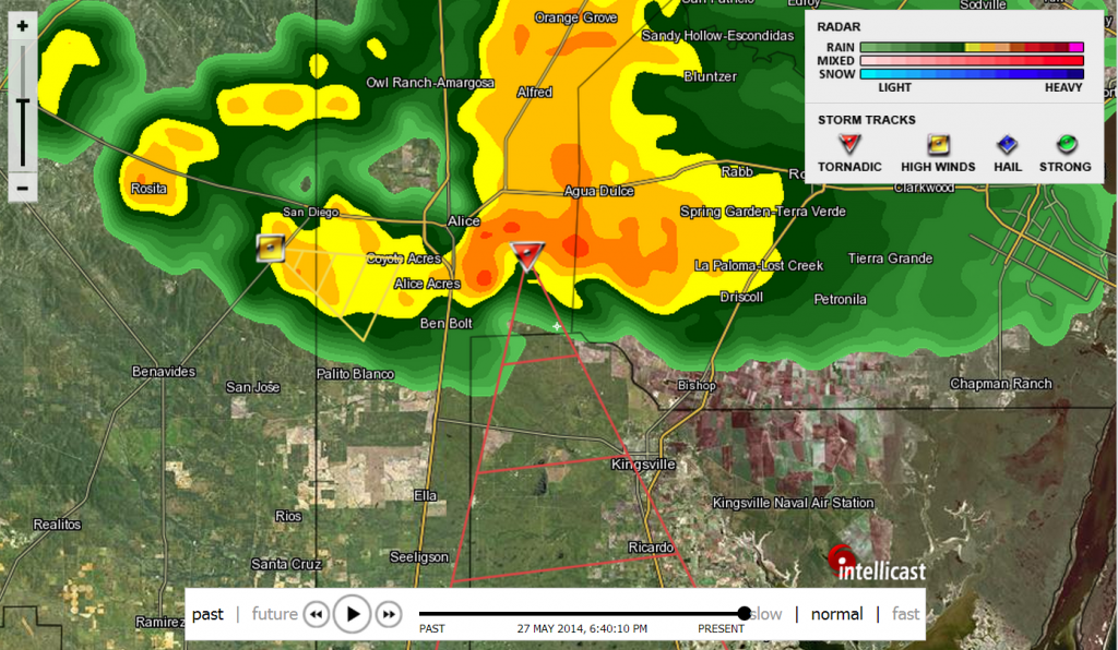
Re: Texas Spring-2014
Tornado Warning on cell NW of Kingsville:
...A TORNADO WARNING REMAINS IN EFFECT UNTIL 700 PM CDT FOR
SOUTHWESTERN NUECES...NORTHWESTERN KLEBERG AND CENTRAL JIM WELLS
COUNTIES...
AT 641 PM CDT...NATIONAL WEATHER SERVICE DOPPLER RADAR CONTINUED TO
INDICATE A TORNADO. THIS TORNADO WAS LOCATED NEAR BEN BOLT...OR 6
MILES SOUTH OF ALICE...MOVING SOUTH AT 35 MPH.
* LOCATIONS IMPACTED INCLUDE...
RURAL NORTHWESTERN KLEBERG COUNTY...
PRECAUTIONARY/PREPAREDNESS ACTIONS...
IN ADDITION TO THE TORNADO...THIS STORM IS CAPABLE OF PRODUCING
BASEBALL SIZE HAIL AND DESTRUCTIVE STRAIGHT LINE WINDS IN EXCESS OF
70 MPH.
AT 645 PM...THE FIRE CHIEF IN ALICE REPORTS DAMAGE HAS OCCURRED IN
THE CITY OF ALICE FROM TORNADO.

0 likes
-
aggiecutter
- Category 5
- Posts: 1755
- Joined: Thu Oct 14, 2004 9:22 pm
- Location: Texarkana
Re: Texas Spring-2014
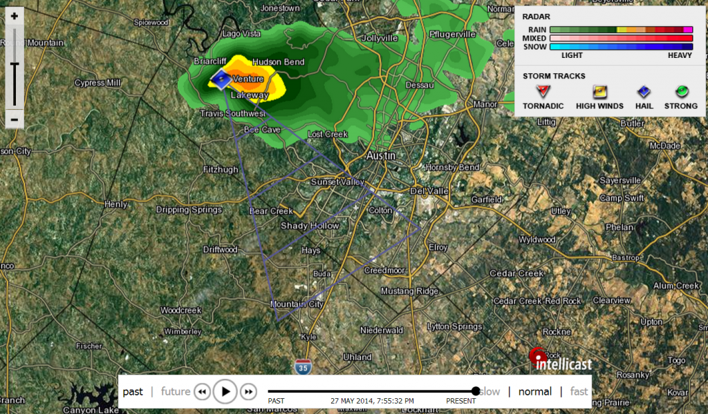
SEVERE THUNDERSTORM WARNING
TXC209-453-280130-
/O.NEW.KEWX.SV.W.0098.140528T0045Z-140528T0130Z/
BULLETIN - EAS ACTIVATION REQUESTED
SEVERE THUNDERSTORM WARNING
NATIONAL WEATHER SERVICE AUSTIN/SAN ANTONIO TX
745 PM CDT TUE MAY 27 2014
THE NATIONAL WEATHER SERVICE IN AUSTIN SAN ANTONIO HAS ISSUED A
* SEVERE THUNDERSTORM WARNING FOR...
CENTRAL HAYS COUNTY...
WESTERN TRAVIS COUNTY...
* UNTIL 830 PM CDT.
* AT 743 PM CDT...NWS METEOROLOGISTS HAVE DETECTED A SEVERE
THUNDERSTORM CAPABLE OF PRODUCING QUARTER SIZE HAIL...AND DAMAGING
WINDS IN EXCESS OF 60 MPH. THIS STORM WAS LOCATED NEAR LAKEWAY...
OR 13 MILES WEST OF ANDERSON MILL...AND MOVING SOUTHEAST AT 30 MPH.
* SOME LOCATIONS IN THE WARNING INCLUDE BEE CAVE...MANSFIELD DAM...
DRIPPING SPRINGS...WEST LAKE HILLS...ROLLINGWOOD...DRIFTWOOD...
TANGLEWOOD FOREST...AUSTIN BERGSTROM INT AP AND ONION CREEK.

0 likes
-
TeamPlayersBlue
- Category 5
- Posts: 3530
- Joined: Tue Feb 02, 2010 1:44 am
- Location: Denver/Applewood, CO
I need to check when this cell started with the rain again here. I had to get up to close windows and i had a new 1.3 inches at the moment and i could promise it hadnt been raining for more than 15 minutes. Was adding .2 inches every update on my weather center. Sounds like Cypress will go over its banks too according to the NWS
0 likes
Personal Forecast Disclaimer:
The posts in this forum are NOT official forecast and should not be used as such. They are just the opinion of the poster and may or may not be backed by sound meteorological data. They are NOT endorsed by any professional institution or storm2k.org. For official information, please refer to the NHC and NWS products.
The posts in this forum are NOT official forecast and should not be used as such. They are just the opinion of the poster and may or may not be backed by sound meteorological data. They are NOT endorsed by any professional institution or storm2k.org. For official information, please refer to the NHC and NWS products.
Re:
ndale wrote:We got another 2 inches of rain since last night, makes the 2 day total to over 4.25 inches.
Woohoo! Good for you guys!
We got dry slotted. Storm total at my house 0.15
0 likes
The above post and any post by dhweather is NOT an official forecast and should not be used as such. It is just the opinion of the poster and may or may not be backed by sound meteorological data. It is NOT endorsed by any professional institution including storm2k.org. For official information, please refer to NWS products.
-
weatherdude1108
- Category 5
- Posts: 4228
- Joined: Tue Dec 13, 2011 1:04 pm
- Location: Northwest Austin/Cedar Park, TX
Re: Re:
dhweather wrote:ndale wrote:We got another 2 inches of rain since last night, makes the 2 day total to over 4.25 inches.
Woohoo! Good for you guys!
We got dry slotted. Storm total at my house 0.15
I feel for you dhweather. That has been our luck the past several events, with the exception of this last one, and maybe the one a couple weeks ago. Sorry about that.
0 likes
-
horselattitudesfarm

- Category 1

- Posts: 315
- Joined: Thu Jul 16, 2009 5:55 pm
- Location: Asheville, NC (formerly from Dallas, TX)
Re: Texas Spring-2014
I posted a picture Intellicast's weekly precip. map showing the donut hole that occurred around Dallas County with this last storm system to prove Dhweather's point:


0 likes
Return to “USA & Caribbean Weather”
Who is online
Users browsing this forum: Stratton23 and 33 guests