Texas Summer - 2014
Moderator: S2k Moderators
Forum rules

The posts in this forum are NOT official forecast and should not be used as such. They are just the opinion of the poster and may or may not be backed by sound meteorological data. They are NOT endorsed by any professional institution or STORM2K.
-
TeamPlayersBlue

- Category 5

- Posts: 3530
- Joined: Tue Feb 02, 2010 1:44 am
- Location: Denver/Applewood, CO
Great great rain for you guys, think it makes it to SE Texas? I think it will and possibly slow up as it approaches. That may not be good though since its so saturated right now. My buddys dock at his river house on the San Bernard had 5 inches of mud that needed to be cleaned before activities started. Not very much fun.
0 likes
Personal Forecast Disclaimer:
The posts in this forum are NOT official forecast and should not be used as such. They are just the opinion of the poster and may or may not be backed by sound meteorological data. They are NOT endorsed by any professional institution or storm2k.org. For official information, please refer to the NHC and NWS products.
The posts in this forum are NOT official forecast and should not be used as such. They are just the opinion of the poster and may or may not be backed by sound meteorological data. They are NOT endorsed by any professional institution or storm2k.org. For official information, please refer to the NHC and NWS products.


By the way, euro is showing another slow trough to the west late week into next week with HP ridge over the SE US putting Tx in the lane of good flow for rain and maybe another front.
Weak low 5h low may spark daytime storms this week in the eastern parts of the state.
Weak low 5h low may spark daytime storms this week in the eastern parts of the state.
0 likes
The above post and any post by Ntxw is NOT an official forecast and should not be used as such. It is just the opinion of the poster and may or may not be backed by sound meteorological data. It is NOT endorsed by any professional institution including Storm2k. For official information, please refer to NWS products.
Help support Storm2K!
-
weatherdude1108
- Category 5
- Posts: 4228
- Joined: Tue Dec 13, 2011 1:04 pm
- Location: Northwest Austin/Cedar Park, TX
-
TheProfessor

- Professional-Met

- Posts: 3506
- Age: 29
- Joined: Tue Dec 03, 2013 10:56 am
- Location: Wichita, Kansas
Well, A lot of you not the coast might be extremely happy, or upset. The 6z GFS develops a Tropical system south east of the Yucatan and has it make landfall somewhere between Galveston and Corpus Christi, bringing beneficial rainfall to the state, It looked like it had it hit land as a strong tropical storm or a weak cat 1 hurricane, but if the storm does form, we'll have to watch it because all it takes is for a couple of things in the atmosphere to go right that could cause this storm from being a beneficial rain maker to a devastating landfall
0 likes
An alumnus of The Ohio State University.
Your local National Weather Service office is your best source for weather information.
Your local National Weather Service office is your best source for weather information.
-
Tireman4

- S2K Supporter

- Posts: 5903
- Age: 60
- Joined: Fri Jun 30, 2006 1:08 pm
- Location: Humble, Texas
- Contact:
Re:
TheProfessor wrote:Well, A lot of you not the coast might be extremely happy, or upset. The 6z GFS develops a Tropical system south east of the Yucatan and has it make landfall somewhere between Galveston and Corpus Christi, bringing beneficial rainfall to the state, It looked like it had it hit land as a strong tropical storm or a weak cat 1 hurricane, but if the storm does form, we'll have to watch it because all it takes is for a couple of things in the atmosphere to go right that could cause this storm from being a beneficial rain maker to a devastating landfall
Ed might like it.
0 likes
I would not trust the GFS. For example today's 12z run has a landfalling cane in Texas. I highly doubt this, its been spinning erroneous tropical cyclones the past few weeks with none coming true. I do believe the influx of moisture though with SE ridge like the euro has.
0 likes
The above post and any post by Ntxw is NOT an official forecast and should not be used as such. It is just the opinion of the poster and may or may not be backed by sound meteorological data. It is NOT endorsed by any professional institution including Storm2k. For official information, please refer to NWS products.
Help support Storm2K!
Help support Storm2K!
-
TeamPlayersBlue
- Category 5
- Posts: 3530
- Joined: Tue Feb 02, 2010 1:44 am
- Location: Denver/Applewood, CO
Interesting it showed it twice in a row though. What i have learned, if youre expecting landfall 12 days out, slim chance you even get hit Lol
0 likes
Personal Forecast Disclaimer:
The posts in this forum are NOT official forecast and should not be used as such. They are just the opinion of the poster and may or may not be backed by sound meteorological data. They are NOT endorsed by any professional institution or storm2k.org. For official information, please refer to the NHC and NWS products.
The posts in this forum are NOT official forecast and should not be used as such. They are just the opinion of the poster and may or may not be backed by sound meteorological data. They are NOT endorsed by any professional institution or storm2k.org. For official information, please refer to the NHC and NWS products.
-
aggiecutter
- Category 5
- Posts: 1755
- Joined: Thu Oct 14, 2004 9:22 pm
- Location: Texarkana
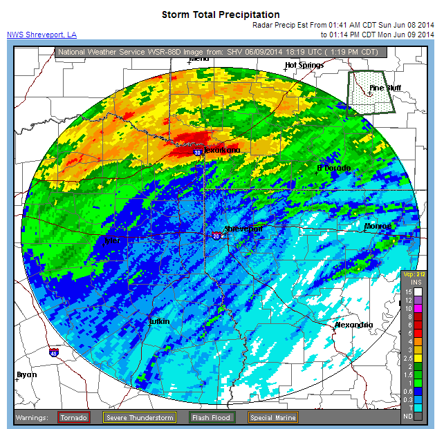
Rainfall total so far in Texarkana is around 4". Some areas north and west of the city have reported over 6".

Last edited by aggiecutter on Mon Jun 09, 2014 1:27 pm, edited 1 time in total.
0 likes
-
weatherdude1108
- Category 5
- Posts: 4228
- Joined: Tue Dec 13, 2011 1:04 pm
- Location: Northwest Austin/Cedar Park, TX
-
TeamPlayersBlue
- Category 5
- Posts: 3530
- Joined: Tue Feb 02, 2010 1:44 am
- Location: Denver/Applewood, CO
Storms are getting stronger and slowing down. Hopefully e get some good rain but not too much since my buddy has his boat on the dock again
0 likes
Personal Forecast Disclaimer:
The posts in this forum are NOT official forecast and should not be used as such. They are just the opinion of the poster and may or may not be backed by sound meteorological data. They are NOT endorsed by any professional institution or storm2k.org. For official information, please refer to the NHC and NWS products.
The posts in this forum are NOT official forecast and should not be used as such. They are just the opinion of the poster and may or may not be backed by sound meteorological data. They are NOT endorsed by any professional institution or storm2k.org. For official information, please refer to the NHC and NWS products.
Re: Texas Summer - 2014
Dr Ventrice posted this on twitter. Looks like the annual summer solstice heat wave may be a little muted this year. The longer we delay the first 100F day the better! Lets go for 0!

0 likes
The above post and any post by Ntxw is NOT an official forecast and should not be used as such. It is just the opinion of the poster and may or may not be backed by sound meteorological data. It is NOT endorsed by any professional institution including Storm2k. For official information, please refer to NWS products.
Help support Storm2K!
Help support Storm2K!
On cue, TD 3 in the EPAC is now TS Cristina! Lets see how she influences the STJ as she tracks westward, possibly as a Hurricane. Unlike over the gulf/carib these EPAC systems modeled are not phantoms this year.

0 likes
The above post and any post by Ntxw is NOT an official forecast and should not be used as such. It is just the opinion of the poster and may or may not be backed by sound meteorological data. It is NOT endorsed by any professional institution including Storm2k. For official information, please refer to NWS products.
Help support Storm2K!
Help support Storm2K!

Re: Texas Summer - 2014
horselattitudesfarm wrote:Tell me anyone, is this a radar issue or did a band of precip. really set up along I-35 3 times in 2 months on these weekly totals:
First time: May 4th-May 11th
Second time: May 14th-May 21rst
3rd. time: June 1rst- June 8th


It's not unusual for a band of precip to develop right up along the Balcones Escarpment through the Austin area. Moisture tends up build up where the coastal plains meet the eastern edge of the Hill Country and will fall as light rain especially early in the mornings this time of year. It's also been a major factor during some flood events when storms train along the escarpment. The floods this past October are a great example of that. Major flooding in Austin but drive over to Lake Travis and very little rain fell in that area and a few more miles west not a drop fell. Some days it can stay cloudy in Austin all day while it's sunny from Lake Travis west. This past May 27th was a good example of that. Storms were able to form over the Hill Country and quickly became supercells due to clear skies destabilizing the atmosphere while it stayed cloudy in Austin through the day.
0 likes
Resident Rain Miser
I am a weather hobbyist living 3.5 miles south of Downtown Austin and in no way or fashion should anything I say concerning forecasts be taken seriously. Please check your local NWS for accurate weather forecasting and conditions.
I am a weather hobbyist living 3.5 miles south of Downtown Austin and in no way or fashion should anything I say concerning forecasts be taken seriously. Please check your local NWS for accurate weather forecasting and conditions.
-
South Texas Storms

- Professional-Met
- Posts: 4256
- Joined: Thu Jun 24, 2010 12:28 am
- Location: Houston, TX
Re: Texas Summer - 2014
horselattitudesfarm wrote:Tell me anyone, is this a radar issue or did a band of precip. really set up along I-35 3 times in 2 months on these weekly totals:
First time: May 4th-May 11th
[img]http://img841.imageshack.us/img841/7618/b690.gif
Second time: May 14th-May 21rst
[img]http://img856.imageshack.us/img856/2186/kadp.jpg
3rd. time: June 1rst- June 8th
[img]http://img834.imageshack.us/img834/5609/nhj69.jpg
It's a radar issue. I've noticed that error in the rainfall totals as well several times throughout the past few months.
0 likes
Return to “USA & Caribbean Weather”
Who is online
Users browsing this forum: CaptinCrunch, HurricaneBelle, Stratton23 and 481 guests