ATL: ARTHUR - Post-Tropical - Discussion
Moderator: S2k Moderators
-
floridasun78
- Category 5

- Posts: 3755
- Joined: Sun May 17, 2009 10:16 pm
- Location: miami fl
Re: ATL: INVEST 91L - Discussion
i was driving from hollywood fl to miami it coming hard we have good rain band from 91l
0 likes

-
ozonepete
- Professional-Met

- Posts: 4743
- Joined: Mon Sep 07, 2009 3:23 pm
- Location: From Ozone Park, NYC / Now in Brooklyn, NY
Re: ATL: INVEST 91L - Discussion
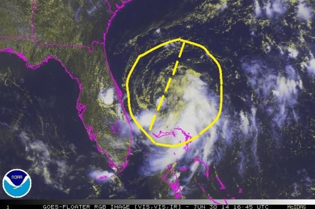
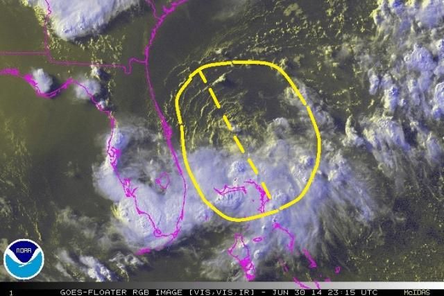
I think it's stopping now because it's getting ready to change direction. Probably also why the center is a little harder to find as it's motion is changing at the same time the LLC is trying to consolidate. I annotated these images to show how the north to south axis of the storm has changed. In the earlier image from 1645 UTC the storm was heading SSW and that's the way the low to mid level clouds were oriented. On the second, latest one from 2315 UTC note how the orientation of the low and mid-level clouds is now oriented from SSE to NNW. It's not going any further south and can't go straight west so it's getting stretched towards the NW and NNW which is probably where it will start to head overnight. It's stopped and is now going to move towards the path of least resistance - northwest That's what it looks like to me.
1645 UTC:
2315 UTC:
1645 UTC:

2315 UTC:

0 likes

Re: ATL: INVEST 91L - Discussion
last few frames almost look like shear is increasing. clouds being blown off the whole thing towards the SE
0 likes
Ginger-(eye),Dennis,Diana,Kate,Gloria,Charley-(eye),Allison,Arthur,Bertha,Fran,Josephine,Bonnie,Earl,Dennis-(twice),Floyd, Isabel-(eye),Charley,Ophelia-(eyewall),Ernesto,Barry,Hanna,Irene-(eye),Arthur-(eye), Florence, Dorian, and countless depressions, storms, and nor'easters.

Re: Re:
NDG wrote:robbielyn wrote:I think it's 78.5w and 28.2n. The llc has moved a little SE
That's just a little eddy, the main LLC is further south and west.
I disagree. I've watched the first frame where the previous position of the llc was and followed it to just north of Grand Bahama. It looks like it's doing a cyclonic loop to change direction and start heading north. It's my story and im sticking to it.
0 likes
Robbielyn McCrary
I know just about enough to sound like I know what I'm talking about sometimes. But for your safety please follow the nhc for truly professional forecasting.
I know just about enough to sound like I know what I'm talking about sometimes. But for your safety please follow the nhc for truly professional forecasting.
-
SeGaBob
I'm thinking that now we won't get TD One at 11pm... looks rather elongated even though the pressure has come down.
Might be lucky to get it tomorrow but I'm starting to wonder about that...
Personal Forecast Disclaimer:
The posts in this forum are NOT official forecast and should not be used as such. They are just the opinion of the poster and may or may not be backed by sound meteorological data. They are NOT endorsed by any professional institution or storm2k.org. For official information, please refer to the NHC and NWS products.
0 likes
Re:
SeGaBob wrote:I'm thinking that now we won't get TD One at 11pm... looks rather elongated even though the pressure has come down.
Probably not. Latest frames doesn't even show a tropical looking anything. It looks liked it collapsed. Maybe that's why they held off dry air killing it and shear
0 likes
Robbielyn McCrary
I know just about enough to sound like I know what I'm talking about sometimes. But for your safety please follow the nhc for truly professional forecasting.
I know just about enough to sound like I know what I'm talking about sometimes. But for your safety please follow the nhc for truly professional forecasting.
-
Aric Dunn
- Category 5
- Posts: 21238
- Age: 43
- Joined: Sun Sep 19, 2004 9:58 pm
- Location: Ready for the Chase.
- Contact:
Re: ATL: INVEST 91L - Discussion
ozonepete wrote:I think it's stopping now because it's getting ready to change direction. Probably also why the center is a little harder to find as it's motion is changing at the same time the LLC is trying to consolidate. I annotated these images to show how the north to south axis of the storm has changed. In the earlier image from 1645 UTC the storm was heading SSW and that's the way the low to mid level clouds were oriented. On the second, latest one from 2315 UTC note how the orientation of the low and mid-level clouds is now oriented from SSE to NNW. It's not going any further south and can't go straight west so it's getting stretched towards the NW and NNW which is probably where it will start to head overnight. It's stopped and is now going to move towards the path of least resistance - northwest That's what it looks like to me.
1645 UTC:
2315 UTC:
right and its elongated do to the multiple vorts that developed. though the the vort moving to the east at the moment seems have tucked under all the developing convection and if it can maintain may help organize and consolidate the a center.
0 likes
Note: If I make a post that is brief. Please refer back to previous posts for the analysis or reasoning. I do not re-write/qoute what my initial post said each time.
If there is nothing before... then just ask
Space & Atmospheric Physicist, Embry-Riddle Aeronautical University,
I believe the sky is falling...
If there is nothing before... then just ask
Space & Atmospheric Physicist, Embry-Riddle Aeronautical University,
I believe the sky is falling...

Re: ATL: INVEST 91L - Discussion
Alyono wrote:ronjon wrote:91L seems to be fighting for its life now. Struggling with that surge of hot dry continental air from the north. The models were on to something in that they really never developed it until it was much further north where RH and PW values are progged to be higher under the influence of the trough and Bermuda high - plus aided by a baroclinic kick. As last season told us, mid-level dry air can really hamper these developing systems.
not fighting for its life at all. It continues to intensify based upon the surface data. Pressure down to 1008mb
I'm not convinced Alyono. SAT presentation is degrading. It's being killed by low RH air and subsidence from the ridge to its NW. Can it hold its own over the next day or so. Sure. But I see little evidence at present of a deepening system. Yes pressure dropped a few mb but until I see more than one half circle of convection I don't see any better organized system.
0 likes
-
ozonepete
- Professional-Met
- Posts: 4743
- Joined: Mon Sep 07, 2009 3:23 pm
- Location: From Ozone Park, NYC / Now in Brooklyn, NY
Re: ATL: INVEST 91L - Discussion
I also think it doesn't look that hot right now. From all of the data I looked at and the satellite loops I think it's still got north-northwesterly shear that's blowing the thunderstorm tops off. The data doesn't show much dry air at all at 700mb or 500mb and by now much of the residual dry air should have been entrained and mixed out. Although there's probably some dry air issues left, I don't think that's nearly as important as the shear. Now we'll probably have to wait until tomorrow afternoon when shear starts dropping off. Ok, well maybe sooner; whenever the shear drops off.
0 likes
Re:
SeGaBob wrote:I think about 50/60% would be reasonable development chances right now.
those would be extremely UNREASONABLE and I would be here calling out NHC if they assigned those probs
This is a guaranteed developer
0 likes
-
Blown Away

- S2K Supporter

- Posts: 10253
- Joined: Wed May 26, 2004 6:17 am
Re: ATL: INVEST 91L - Discussion

0 likes
Hurricane Eye Experience: David 79, Irene 99, Frances 04, Jeanne 04, Wilma 05… Hurricane Brush Experience: Andrew 92, Erin 95, Floyd 99, Matthew 16, Irma 17, Ian 22, Nicole 22…
Based on a long loop radar I think movement south has stopped, it may be slipping west if anything, but can't tell if the center is elongated or not from that alone. The northern semicircle is still pathetic.
0 likes

-
ozonepete
- Professional-Met
- Posts: 4743
- Joined: Mon Sep 07, 2009 3:23 pm
- Location: From Ozone Park, NYC / Now in Brooklyn, NY
Re:
SeGaBob wrote:I think about 50/60% would be reasonable development chances right now.
No. I think 80% is fine. I would go 90 or 100 myself.
0 likes
-
cycloneye

- Admin

- Posts: 149511
- Age: 69
- Joined: Thu Oct 10, 2002 10:54 am
- Location: San Juan, Puerto Rico
Re: ATL: INVEST 91L - Discussion
ozonepete wrote:I also think it doesn't look that hot right now. From all of the data I looked at and the satellite loops I think it's still got north-northwesterly shear that's blowing the thunderstorm tops off. The data doesn't show much dry air at all at 700mb or 500mb and by now much of the residual dry air should have been entrained and mixed out. Although there's probably some dry air issues left, I don't think that's nearly as important as the shear. Now we'll probably have to wait until tomorrow afternoon when shear starts dropping off. Ok, well maybe sooner; whenever the shear drops off.
is the best word to use as mother nature do it's thing in the atmosphere on it's own timetable.whenever
0 likes
Visit the Caribbean-Central America Weather Thread where you can find at first post web cams,radars
and observations from Caribbean basin members Click Here
and observations from Caribbean basin members Click Here
-
ozonepete
- Professional-Met
- Posts: 4743
- Joined: Mon Sep 07, 2009 3:23 pm
- Location: From Ozone Park, NYC / Now in Brooklyn, NY
Re: ATL: INVEST 91L - Discussion
cycloneye wrote:ozonepete wrote:I also think it doesn't look that hot right now. From all of the data I looked at and the satellite loops I think it's still got north-northwesterly shear that's blowing the thunderstorm tops off. The data doesn't show much dry air at all at 700mb or 500mb and by now much of the residual dry air should have been entrained and mixed out. Although there's probably some dry air issues left, I don't think that's nearly as important as the shear. Now we'll probably have to wait until tomorrow afternoon when shear starts dropping off. Ok, well maybe sooner; whenever the shear drops off.is the best word to use as mother nature do it's thing in the atmosphere on it's own timetable.whenever
lol! the simple truth.
0 likes
Who is online
Users browsing this forum: No registered users and 62 guests