
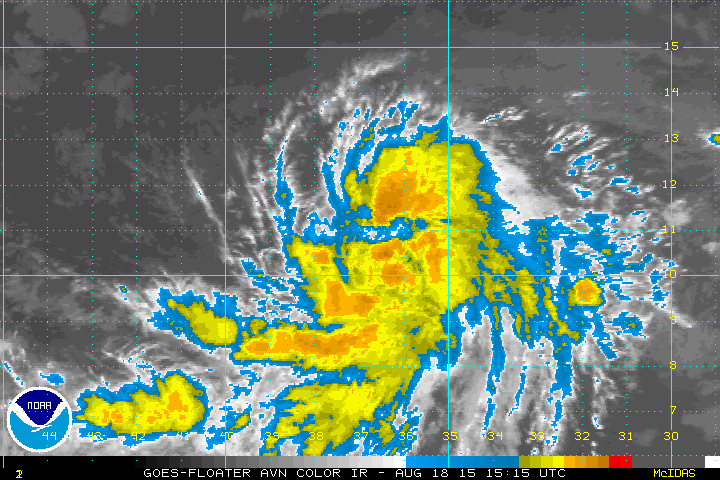
I fixed the center on our radar about 70E of VRB-FPR. I don't see any sort of surface center near West End GBI. If it was near there, then SLP would be falling and the wind slackening at the SPGF1 C-MAN, and it's not (currently 220/29P32KT).
You can see multiple small eddies have been whirling about on both the north and south sides of the center since this morning,
ATL: ARTHUR - Post-Tropical - Discussion
Moderator: S2k Moderators
-
Aric Dunn
- Category 5

- Posts: 21238
- Age: 43
- Joined: Sun Sep 19, 2004 9:58 pm
- Location: Ready for the Chase.
- Contact:
Re: ATL: ARTHUR - Tropical Storm - Discussion
northjaxpro wrote:Aric Dunn wrote:northjaxpro wrote:
That's where the coldest cloud tops are being observed on IR imagery. The COC is within that area in my opinion as well or just west of the western tip of Grand Bahama Island. We will find out when Recon gets in there.
not a center relocation. rather thats where all the new vorts are starting from. the mid level circ is down there and with all the convection there is general lowering of pressure within the convection .. it produces a vort that then begins rotating around the other.. been going on for about 24 hour now. the northern vort is beginning to drop wsw to sw as the other vort starting to come out of the convection again... the mean center is about east of Fort pierce.
Yeah, Aric, I see what you are saying. However, it seems that the circulation west/northwest of the western tip of Cuba sure looks very vigourous with impressive convective cloud tops rotating around it. Like everyone, we are anxiously awaiting Recon to get in there to see what is going on, but the vort down west of the western tip of Grand Bahama Island certainly looks better than the circulation east of Fort Pierce. Just an observation.
not saying one might die, just saying right now there are still 2 vort out there.. outflow is becoming more defined sign the shear is dropping. only a matter of time before it works out the remaining dry air and consolidates. but atm still 2 vorts
0 likes
Note: If I make a post that is brief. Please refer back to previous posts for the analysis or reasoning. I do not re-write/qoute what my initial post said each time.
If there is nothing before... then just ask
Space & Atmospheric Physicist, Embry-Riddle Aeronautical University,
I believe the sky is falling...
If there is nothing before... then just ask
Space & Atmospheric Physicist, Embry-Riddle Aeronautical University,
I believe the sky is falling...
-
northjaxpro

- S2K Supporter

- Posts: 8900
- Joined: Mon Sep 27, 2010 11:21 am
- Location: Jacksonville, FL
Re:
AJC3 wrote:I fixed the center on our radar about 70E of VRB-FPR. I don't see any sort of surface center near West End GBI. If it was near there, then SLP would be falling and the wind slackening at the SPGF1 C-MAN, and it's not (currently 220/29P32KT).
You can see multiple small eddies have been whirling about on both the north and south sides of the center since this morning,
Yes, there are several eddies for sure.
0 likes
NEVER, EVER SAY NEVER in the tropics and weather in general, and most importantly, with life itself!!
________________________________________________________________________________________
Fay 2008 Beryl 2012 Debby 2012 Colin 2016 Hermine 2016 Julia 2016 Matthew 2016 Irma 2017 Dorian 2019
________________________________________________________________________________________
Fay 2008 Beryl 2012 Debby 2012 Colin 2016 Hermine 2016 Julia 2016 Matthew 2016 Irma 2017 Dorian 2019
-
supercane4867
- Category 5
- Posts: 4966
- Joined: Wed Nov 14, 2012 10:43 am
Re: ATL: ARTHUR - Tropical Storm - Discussion
High resolution RGB imagery of TS Arthur around 15z

0 likes

Re:
AJC3 wrote:I fixed the center on our radar about 70E of VRB-FPR. I don't see any sort of surface center near West End GBI. If it was near there, then SLP would be falling and the wind slackening at the SPGF1 C-MAN, and it's not (currently 220/29P32KT).
You can see multiple small eddies have been whirling about on both the north and south sides of the center since this morning,
Exactly right, the C-MAN station's reported pressure is only at 1011.5mb, if the surface LLC would had been closer their pressure would had been lower than that, IMO.
0 likes
-
tropicwatch

- Category 5
- Posts: 3426
- Age: 62
- Joined: Sat Jun 02, 2007 10:01 am
- Location: The Villages, Florida
- Contact:
Re: ATL: ARTHUR - Tropical Storm - Discussion
Looks like the out flow is starting to set up. Not that great yet.
0 likes
Tropicwatch
Agnes 72', Eloise 75, Elena 85', Kate 85', Charley 86', Florence 88', Beryl 94', Dean 95', Erin 95', Opal 95', Earl 98', Georges 98', Ivan 2004', Arlene 2005', Dennis 2005', Ida 2009' Debby 2012' Irma 2017' Michael 2018'
Agnes 72', Eloise 75, Elena 85', Kate 85', Charley 86', Florence 88', Beryl 94', Dean 95', Erin 95', Opal 95', Earl 98', Georges 98', Ivan 2004', Arlene 2005', Dennis 2005', Ida 2009' Debby 2012' Irma 2017' Michael 2018'

-
northjaxpro
- S2K Supporter
- Posts: 8900
- Joined: Mon Sep 27, 2010 11:21 am
- Location: Jacksonville, FL
Re: Re:
NDG wrote:AJC3 wrote:I fixed the center on our radar about 70E of VRB-FPR. I don't see any sort of surface center near West End GBI. If it was near there, then SLP would be falling and the wind slackening at the SPGF1 C-MAN, and it's not (currently 220/29P32KT).
You can see multiple small eddies have been whirling about on both the north and south sides of the center since this morning,
Exactly right, the C-MAN station's reported pressure is only at 1011.5mb, if the surface LLC would had been closer their pressure would had been lower than that, IMO.
This likely confirms the COC is the one due east of Fort Pierce based on the C-MAN station ob.
0 likes
NEVER, EVER SAY NEVER in the tropics and weather in general, and most importantly, with life itself!!
________________________________________________________________________________________
Fay 2008 Beryl 2012 Debby 2012 Colin 2016 Hermine 2016 Julia 2016 Matthew 2016 Irma 2017 Dorian 2019
________________________________________________________________________________________
Fay 2008 Beryl 2012 Debby 2012 Colin 2016 Hermine 2016 Julia 2016 Matthew 2016 Irma 2017 Dorian 2019
-
cfltrib
- Tropical Low

- Posts: 24
- Age: 72
- Joined: Sun Jun 24, 2012 3:06 pm
- Location: Hayesville, NC, formerly FL
Seams to be centralizing circulation in the radar loop. As I stated a while ago: appears to be centered just northwest of western tip of Grand Bahama.
http://www.ssd.noaa.gov/PS/TROP/floater ... -long.html
http://www.ssd.noaa.gov/PS/TROP/floater ... -long.html
0 likes
-
Aric Dunn
- Category 5
- Posts: 21238
- Age: 43
- Joined: Sun Sep 19, 2004 9:58 pm
- Location: Ready for the Chase.
- Contact:
Re: Re:
northjaxpro wrote:NDG wrote:AJC3 wrote:I fixed the center on our radar about 70E of VRB-FPR. I don't see any sort of surface center near West End GBI. If it was near there, then SLP would be falling and the wind slackening at the SPGF1 C-MAN, and it's not (currently 220/29P32KT).
You can see multiple small eddies have been whirling about on both the north and south sides of the center since this morning,
Exactly right, the C-MAN station's reported pressure is only at 1011.5mb, if the surface LLC would had been closer their pressure would had been lower than that, IMO.
This likely confirms the COC is the one due east of Fort Pierce based on the C-MAN station ob.
then the center is moving wsw in that case. only way were getting that type of motion is if it is rotating around something..
0 likes
Note: If I make a post that is brief. Please refer back to previous posts for the analysis or reasoning. I do not re-write/qoute what my initial post said each time.
If there is nothing before... then just ask
Space & Atmospheric Physicist, Embry-Riddle Aeronautical University,
I believe the sky is falling...
If there is nothing before... then just ask
Space & Atmospheric Physicist, Embry-Riddle Aeronautical University,
I believe the sky is falling...
-
cycloneye

- Admin

- Posts: 149519
- Age: 69
- Joined: Thu Oct 10, 2002 10:54 am
- Location: San Juan, Puerto Rico
Re: ATL: ARTHUR - Tropical Storm - Discussion
18z Best Track
Pressure is falling and winds going up.
AL, 01, 2014070118, , BEST, 0, 277N, 793W, 40, 1003, TS
Pressure is falling and winds going up.
AL, 01, 2014070118, , BEST, 0, 277N, 793W, 40, 1003, TS
0 likes
Visit the Caribbean-Central America Weather Thread where you can find at first post web cams,radars
and observations from Caribbean basin members Click Here
and observations from Caribbean basin members Click Here
-
Bocadude85

- Category 5
- Posts: 2991
- Age: 39
- Joined: Mon Apr 18, 2005 2:20 pm
- Location: Honolulu,Hi
Re: ATL: ARTHUR - Tropical Storm - Discussion
If the center is east of Ft. Pierce then Arthur will be making landfall in Florida sometime tonight... you can see the center E of Ft Pierce heading westward. Just my opinion.
0 likes
-
jaxfladude
- Category 5
- Posts: 1249
- Joined: Wed Aug 24, 2005 9:36 pm
- Location: Jacksonville, Fla
Re: ATL: ARTHUR - Tropical Storm - Discussion
supercane4867 wrote:High resolution RGB imagery of TS Arthur around 15z
http://i60.tinypic.com/fauflw.jpg
Wow, it looks very nice for a T.S. with the all that the system now known as "Arthur" has gone thru and continues to do so.
Better not get it's "act together"....
My best to all!
Edit to add:
Personal Forecast Disclaimer:
The posts in this forum are NOT official forecast and should not be used as such. They are just the opinion of the poster and may or may not be backed by sound meteorological data. They are NOT endorsed by any professional institution or storm2k.org. For official information, please refer to the NHC and NWS products.
0 likes
Stay safe y'all
-
eastcoastFL

- Category 5
- Posts: 3996
- Age: 44
- Joined: Thu Apr 12, 2007 12:29 pm
- Location: Palm City, FL
Re: ATL: ARTHUR - Tropical Storm - Discussion
It appears the coastal towns further south from the center have been feeling the majority of the affects. I am in stuart its been raining on and off and windy. My wife is in west palm and its been storming all day.
Bocadude85 wrote:If the center is east of Ft. Pierce then Arthur will be making landfall in Florida sometime tonight... you can see the center E of Ft Pierce heading westward. Just my opinion.
0 likes
Personal Forecast Disclaimer:
The posts in this forum are NOT official forecast and should not be used as such. They are just the opinion of the poster and may or may not be backed by sound meteorological data. They are NOT endorsed by any professional institution or storm2k.org. For official information, please refer to the NHC and NWS products.
The posts in this forum are NOT official forecast and should not be used as such. They are just the opinion of the poster and may or may not be backed by sound meteorological data. They are NOT endorsed by any professional institution or storm2k.org. For official information, please refer to the NHC and NWS products.
Vortex message confirms the best track position by the NHC.
URNT12 KNHC 011848
VORTEX DATA MESSAGE AL012014
A. 01/18:23:20Z
B. 27 deg 42 min N
079 deg 18 min W
C. 925 mb 715 m
D. 37 kt
E. 321 deg 33 nm
F. 056 deg 34 kt
G. 321 deg 33 nm
H. EXTRAP 1003 mb
I. 20 C / 754 m
J. 22 C / 760 m
K. NA / NA
L. NA
M. NA
N. 12345 / 09
O. 0.02 / 2 nm
P. AF307 0201A ARTHUR OB 05
MAX OUTBOUND AND MAX FL WIND 61 KT 130 / 44 NM 18:38:30Z
SLP EXTRAP FROM 925 MB
POSSIBLE EYEWALL SE-SW
But since this morning it has not moved much.
Last edited by NDG on Tue Jul 01, 2014 1:56 pm, edited 1 time in total.
0 likes
-
cycloneye
- Admin
- Posts: 149519
- Age: 69
- Joined: Thu Oct 10, 2002 10:54 am
- Location: San Juan, Puerto Rico
Re: ATL: ARTHUR - Tropical Storm - Discussion
Wow,look at the flight level winds. 
0 likes
Visit the Caribbean-Central America Weather Thread where you can find at first post web cams,radars
and observations from Caribbean basin members Click Here
and observations from Caribbean basin members Click Here
-
hurricanes1234
- Category 5
- Posts: 2908
- Joined: Sat Jul 28, 2012 6:19 pm
- Location: Trinidad and Tobago
Possible eyewall already?
0 likes
PLEASE NOTE: With the exception of information from weather agencies that I may copy and paste here, my posts will NEVER be official, since I am NOT a meteorologist. They are solely my amateur opinion, and may or may not be accurate. Therefore, please DO NOT use them as official details, particularly when making important decisions. Thank you.
Re: ATL: ARTHUR - Tropical Storm - Discussion
cycloneye wrote:Wow,look at the flight level winds.
Yeap, but I am sure is rain contaminated from the deep convection SE of the LLC. Interesting that they mentioned about a possible eyewall forming.
0 likes
-
Aric Dunn
- Category 5
- Posts: 21238
- Age: 43
- Joined: Sun Sep 19, 2004 9:58 pm
- Location: Ready for the Chase.
- Contact:
Re: ATL: ARTHUR - Tropical Storm - Discussion
NDG wrote:cycloneye wrote:Wow,look at the flight level winds.
Yeap, but I am sure is rain contaminated from the deep convection SE of the LLC. Interesting that they mentioned about a possible eyewall forming.
the center they fixed that on... has little to no rain around it... lol cant be a eyewall that has to be a typo.
0 likes
Note: If I make a post that is brief. Please refer back to previous posts for the analysis or reasoning. I do not re-write/qoute what my initial post said each time.
If there is nothing before... then just ask
Space & Atmospheric Physicist, Embry-Riddle Aeronautical University,
I believe the sky is falling...
If there is nothing before... then just ask
Space & Atmospheric Physicist, Embry-Riddle Aeronautical University,
I believe the sky is falling...
Re: ATL: ARTHUR - Tropical Storm - Discussion
Aric Dunn wrote:NDG wrote:cycloneye wrote:Wow,look at the flight level winds.
Yeap, but I am sure is rain contaminated from the deep convection SE of the LLC. Interesting that they mentioned about a possible eyewall forming.
the center they fixed that on... has little to no rain around it... lol cant be a eyewall that has to be a typo.
I am thinking that is probably from the mid level vorticity.
0 likes
Who is online
Users browsing this forum: No registered users and 22 guests