ATL: ARTHUR - Post-Tropical - Discussion
Moderator: S2k Moderators
Considering the photo we (Fort Lauderdale and area) are directly under the feeder band that is feeding (!) directly into Arthur like an umbilical cord, and explains the large amount of lightning we are all seeing the past 2 or 3 hours - considering the amount of energy feeding into the system, we shouldn't be surprised its strengthening this evening...
Last edited by Frank2 on Tue Jul 01, 2014 9:43 pm, edited 1 time in total.
0 likes

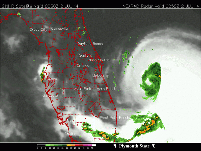
The more I look at the last few frames of the radar loop the more I am starting to see the Arthur is still not vertically stacked, the LLC appears to be just west of the MLC, you can see some light showers heading west on the radar loop just north of where I placed the LLC.
But is getting there little by little.

But is getting there little by little.
0 likes
-
Aric Dunn
- Category 5

- Posts: 21238
- Age: 43
- Joined: Sun Sep 19, 2004 9:58 pm
- Location: Ready for the Chase.
- Contact:
Re: ATL: ARTHUR - Tropical Storm - Discussion
CarolinaNBANFL wrote:What is the likely hood this thing hits Wilmington in percentage chances? I am just a computer programmer who loves watching these storms form and just happen to be moving to Wilmington, NC in a few weeks.
if you go to the NHC web site. you can find them all.
0 likes
Note: If I make a post that is brief. Please refer back to previous posts for the analysis or reasoning. I do not re-write/qoute what my initial post said each time.
If there is nothing before... then just ask
Space & Atmospheric Physicist, Embry-Riddle Aeronautical University,
I believe the sky is falling...
If there is nothing before... then just ask
Space & Atmospheric Physicist, Embry-Riddle Aeronautical University,
I believe the sky is falling...
-
vacanechaser

- Category 5
- Posts: 1461
- Joined: Wed Dec 03, 2003 9:34 pm
- Location: Portsmouth, Va
- Contact:
Re:
Aric Dunn wrote:This process of convection weakening is very typical during the intensification process.. then typically there is a large burst of convection on a portion of the developing eyewall that ends up wrapping around and you get very quick deepening..
Agreed.. Looks to me like it is about to go to town. It won't be long I think before this thing could start to intensify rather quickly.
Jesse V. Bass III
http://www.vastormphoto.com
Hurricane Intercept Research Team
0 likes
-
TropicalAnalystwx13

- Category 5
- Posts: 2109
- Age: 28
- Joined: Tue Jul 19, 2011 8:20 pm
- Location: Wilmington, NC
- Contact:
Re: ATL: ARTHUR - Tropical Storm - Discussion
CarolinaNBANFL wrote:What is the likely hood this thing hits Wilmington in percentage chances? I am just a computer programmer who loves watching these storms form and just happen to be moving to Wilmington, NC in a few weeks.
What does 'hit' mean? We're likely to get torrential rainfall and a period of tropical storm-force winds.
0 likes
-
CarolinaNBANFL
Re: ATL: ARTHUR - Tropical Storm - Discussion
By hit I mean make landfall. I know it is supposed to turn but could that happen later or earlier than expected?
0 likes
-
TheAustinMan

- Category 5
- Posts: 1060
- Joined: Mon Jul 08, 2013 4:26 pm
- Location: Central TX / United States
Re: ATL: ARTHUR - Tropical Storm - Discussion
CarolinaNBANFL wrote:What is the likely hood this thing hits Wilmington in percentage chances? I am just a computer programmer who loves watching these storms form and just happen to be moving to Wilmington, NC in a few weeks.
Per the last National Hurricane Center advisory (this is official) -
*The probability that 34 kt or higher winds will be felt in Wilmington from today til 1800 UTC Sunday is 61%
*The probability that 50 kt or higher winds will be felt in Wilmington from today til 1800 UTC Sunday is 25%
*The probability that 64 kt or higher winds will be felt in Wilmington from today til 1800 UTC Sunday is 8%
For more details see http://www.nhc.noaa.gov/text/refresh/MI ... 2047.shtml
0 likes
Treat my opinions with a grain of salt. For official information see your local weather service.
“It's tough to make predictions, especially about the future.”
“It's tough to make predictions, especially about the future.”
-
Aric Dunn
- Category 5
- Posts: 21238
- Age: 43
- Joined: Sun Sep 19, 2004 9:58 pm
- Location: Ready for the Chase.
- Contact:
Convection filling in.. could be the start..
0 likes
Note: If I make a post that is brief. Please refer back to previous posts for the analysis or reasoning. I do not re-write/qoute what my initial post said each time.
If there is nothing before... then just ask
Space & Atmospheric Physicist, Embry-Riddle Aeronautical University,
I believe the sky is falling...
If there is nothing before... then just ask
Space & Atmospheric Physicist, Embry-Riddle Aeronautical University,
I believe the sky is falling...
-
TropicalAnalystwx13
- Category 5
- Posts: 2109
- Age: 28
- Joined: Tue Jul 19, 2011 8:20 pm
- Location: Wilmington, NC
- Contact:
Re: ATL: ARTHUR - Tropical Storm - Discussion
CarolinaNBANFL wrote:By hit I mean make landfall. I know it is supposed to turn but could that happen later or earlier than expected?
It could, which is why residents in eastern North Carolina -- and coastal sections of the entire Southeast, really -- need to watch this storm closely. A landfall on Wilmington directly seems unlikely, but even a small shift westward would mean much more significant impacts for us.
0 likes
Re: ATL: ARTHUR - Tropical Storm - Discussion
What do you think the correct coordinates are Aric?
0 likes
-
CarolinaNBANFL
This storm worries me because it is very impressive looking and it did not look like that just 24 hours ago. I am not a meteorologist as mentioned but I think this thing has the potential to get extremely powerful just from my experience being in NC and watching hurricanes form over the years. I have seen weaker looking storms get to 80 or 90 in just a few days.
0 likes
-
MaineWeatherNut
- Tropical Storm

- Posts: 225
- Joined: Sun Sep 01, 2013 5:06 pm
Re: ATL: ARTHUR - Tropical Storm - Discussion
TheAustinMan wrote:CarolinaNBANFL wrote:What is the likely hood this thing hits Wilmington in percentage chances? I am just a computer programmer who loves watching these storms form and just happen to be moving to Wilmington, NC in a few weeks.
Per the last National Hurricane Center advisory (this is official) -
*The probability that 34 kt or higher winds will be felt in Wilmington from today til 1800 UTC Sunday is 61%
*The probability that 50 kt or higher winds will be felt in Wilmington from today til 1800 UTC Sunday is 25%
*The probability that 64 kt or higher winds will be felt in Wilmington from today til 1800 UTC Sunday is 8%
For more details see http://www.nhc.noaa.gov/text/refresh/MI ... 2047.shtml
The stronger it gets though the greater those chances become as the wind field expands.
0 likes
The content of this post does NOT constitute official forecast and should not be used as such. They are the opinion of the poster and may or may not be backed by sound meteorological data. They are NOT endorsed by any professional institution or Storm2K. For official information, please refer to the local meteorological centers of respective areas.
-
tolakram
- Admin

- Posts: 20186
- Age: 62
- Joined: Sun Aug 27, 2006 8:23 pm
- Location: Florence, KY (name is Mark)
Re: ATL: ARTHUR - Tropical Storm - Discussion
0 likes
M a r k
- - - - -
Join us in chat: Storm2K Chatroom Invite. Android and IOS apps also available.
The posts in this forum are NOT official forecasts and should not be used as such. Posts are NOT endorsed by any professional institution or STORM2K.org. For official information and forecasts, please refer to NHC and NWS products.
-
Kingarabian

- S2K Supporter

- Posts: 16366
- Joined: Sat Aug 08, 2009 3:06 am
- Location: Honolulu, Hawaii

-
MaineWeatherNut
- Tropical Storm
- Posts: 225
- Joined: Sun Sep 01, 2013 5:06 pm
Re: ATL: ARTHUR - Tropical Storm - Discussion
wow... The NHC is unwilling to do ANYTHING at all with this one until it has the solid data from Recon to back it up... They keep pressure and winds the same at 11pm though it's pretty clearly getting better organized... Oh well Recon takes off in an hour...
0 likes
The content of this post does NOT constitute official forecast and should not be used as such. They are the opinion of the poster and may or may not be backed by sound meteorological data. They are NOT endorsed by any professional institution or Storm2K. For official information, please refer to the local meteorological centers of respective areas.
-
cycloneye

- Admin
- Posts: 149508
- Age: 69
- Joined: Thu Oct 10, 2002 10:54 am
- Location: San Juan, Puerto Rico
Re: ATL: ARTHUR - Tropical Storm - Discussion
Important section of the 11 PM discussion.
Data from the Melbourne WSR-88D radar indicates that Arthur has a
complex structure this evening. A mid-level cyclonic circulation
accompanied by a possible eye feature is clearly evident near 27.8N
78.8W. However, the motions of the light showers/low clouds seen in
the radar data suggest that the low-level center is about 25-30 n mi
west of the mid-level center. Air Force Reserve and NOAA Hurricane
Hunter aircraft are scheduled to investigate Arthur early Wednesday
morning to see if the center has re-formed to the east. Pending the
arrival of the aircraft, the initial intensity remains 45 kt.
0 likes
Visit the Caribbean-Central America Weather Thread where you can find at first post web cams,radars
and observations from Caribbean basin members Click Here
and observations from Caribbean basin members Click Here
-
CarolinaNBANFL
That is NO DOUBT an eye on radar now and that thing is a hurricane or close to it. This thing is really intensifying in front of our eyes hour by hour.
Personal Forecast Disclaimer:
The posts in this forum are NOT official forecast and should not be used as such. They are just the opinion of the poster and may or may not be backed by sound meteorological data. They are NOT endorsed by any professional institution or storm2k.org. For official information, please refer to the NHC and NWS products.
Last edited by tolakram on Tue Jul 01, 2014 9:57 pm, edited 1 time in total.
Reason: added disclaimer
Reason: added disclaimer
0 likes
-
tolakram
- Admin
- Posts: 20186
- Age: 62
- Joined: Sun Aug 27, 2006 8:23 pm
- Location: Florence, KY (name is Mark)
Re: ATL: ARTHUR - Tropical Storm - Discussion
Latest shear analysis shows 5 kts or less.
Time sensitive link, click on the shear checkbox.
http://tropic.ssec.wisc.edu/real-time/storm.frame.php?&basin=atlantic&sname=01L&invest=NO&zoom=2&img=1&vars=1111100000000000000000000&loop=0&llval=
Time sensitive link, click on the shear checkbox.
http://tropic.ssec.wisc.edu/real-time/storm.frame.php?&basin=atlantic&sname=01L&invest=NO&zoom=2&img=1&vars=1111100000000000000000000&loop=0&llval=
0 likes
M a r k
- - - - -
Join us in chat: Storm2K Chatroom Invite. Android and IOS apps also available.
The posts in this forum are NOT official forecasts and should not be used as such. Posts are NOT endorsed by any professional institution or STORM2K.org. For official information and forecasts, please refer to NHC and NWS products.
- - - - -
Join us in chat: Storm2K Chatroom Invite. Android and IOS apps also available.
The posts in this forum are NOT official forecasts and should not be used as such. Posts are NOT endorsed by any professional institution or STORM2K.org. For official information and forecasts, please refer to NHC and NWS products.
-
LSU2001

- S2K Supporter
- Posts: 1711
- Age: 58
- Joined: Sat Sep 11, 2004 11:01 pm
- Location: Cut Off, Louisiana
Re: ATL: ARTHUR - Tropical Storm - Discussion
Hey everyone, back for another cane season 
Looks to me like it's starting to get that fist shape they get before they take off.
Tim
Looks to me like it's starting to get that fist shape they get before they take off.
Tim
0 likes
Personal Forecast Disclaimer:
The posts in this forum are NOT official forecast and should not be used as such. They are NOT endorsed by any professional institution or storm2k.org. For official information, please refer to the NHC and NWS products.
The posts in this forum are NOT official forecast and should not be used as such. They are NOT endorsed by any professional institution or storm2k.org. For official information, please refer to the NHC and NWS products.
Who is online
Users browsing this forum: No registered users and 28 guests