ATL: ARTHUR - Post-Tropical - Discussion

Moderator: S2k Moderators

Message
Author
User avatar
Hurricane_Luis
Category 2
Category 2
Posts: 723
Age: 27
Joined: Sat Jun 23, 2012 3:14 pm
Location: Tiptree, Essex, United Kingdom
Contact:

Re: ATL: ARTHUR - Tropical Storm - Discussion

#1861 Postby Hurricane_Luis » Thu Jul 03, 2014 6:27 am

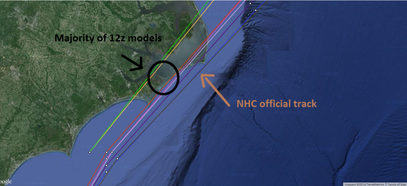
ravyrn wrote:http://i.imgur.com/2wjwfBs.jpg

Anyone got a link to a .kml file that has higher resolution than this when zoomed in for Google Earth? Sorry to be slightly off-topic, but looking for better resolution when posting recon pics and there is no recon discussion thread.

EDIT: Fixed image link.


I sure that Google Earth has a Cloud Overlay somewhere, Its not the best but it does the job.

Tropical Storm Athur

Image
0 likes   

OuterBanker
S2K Supporter
S2K Supporter
Posts: 1731
Joined: Wed Feb 26, 2003 10:53 am
Location: Nags Head, NC
Contact:

Re: ATL: ARTHUR - Hurricane - Discussion

#1862 Postby OuterBanker » Thu Jul 03, 2014 6:30 am

Most locals are thinking that not much is ging to happen. I'm seeing that quite a few just may be surprised. Most disturbing is how the Euro has shifted west with a 977 centered on the obx.
0 likes   

SunnyThoughts
Category 5
Category 5
Posts: 2263
Joined: Wed Jul 09, 2003 12:42 pm
Location: Pensacola, Florida

#1863 Postby SunnyThoughts » Thu Jul 03, 2014 6:38 am

105700 3118N 07829W 6962 03080 //// +072 //// 217078 083 069 028 01
105730 3119N 07831W 6983 03034 //// +074 //// 226080 083 071 032 01
105800 3120N 07832W 6948 03067 //// +080 //// 236071 079 073 030 01

couple of 83 flight level measurements First time in the 80s..I believe.
0 likes   

User avatar
cycloneye
Admin
Admin
Posts: 145382
Age: 68
Joined: Thu Oct 10, 2002 10:54 am
Location: San Juan, Puerto Rico

Re: ATL: ARTHUR - Hurricane - Discussion

#1864 Postby cycloneye » Thu Jul 03, 2014 6:44 am

URNT12 KNHC 031126
VORTEX DATA MESSAGE AL012014
A. 03/11:03:30Z
B. 31 deg 35 min N
078 deg 46 min W
C. 700 mb 2952 m
D. 79 kt
E. 136 deg 15 nm
F. 225 deg 83 kt
G. 136 deg 19 nm
H. 983 mb
I. 7 C / 3045 m
J. 14 C / 3050 m
K. NA / NA
L. CLOSED
M. C25
N. 12345 / 7
O. 0.02 / 3 nm
P. AF303 0901A ARTHUR OB 21
MAX FL WIND 83 KT 136 / 19 NM 10:57:30Z
MAX OUTBOUND FL WIND 53 KT 314 / 17 NM 11:09:00Z
CENTER DROPSONDE SFC WINDS 270/13
EYEWALL RAGGED/BROKEN
0 likes   
Visit the Caribbean-Central America Weather Thread where you can find at first post web cams,radars
and observations from Caribbean basin members Click Here

User avatar
ScottNAtlanta
Category 5
Category 5
Posts: 2367
Joined: Sat May 25, 2013 3:11 pm
Location: Atlanta, GA

Re: ATL: ARTHUR - Hurricane - Discussion

#1865 Postby ScottNAtlanta » Thu Jul 03, 2014 6:49 am

Looks like the beginning of the western side outflow channel starting to set up that is supposed to aid strengthening.
0 likes   
The posts in this forum are NOT official forecast and should not be used as such. They are just the opinion of the poster and may or may not be backed by sound meteorological data. They are NOT endorsed by any professional institution or storm2k.org. For official information, please refer to the NHC and NWS products.

ninel conde

#1866 Postby ninel conde » Thu Jul 03, 2014 6:53 am

http://www.wvec.com/weather/radar?radar ... sz=lrg&c=y

thats why i think arthur will go west of hatteras. yesterday the radar echos around here were going west to east, now they are almost going due north.
0 likes   

User avatar
cycloneye
Admin
Admin
Posts: 145382
Age: 68
Joined: Thu Oct 10, 2002 10:54 am
Location: San Juan, Puerto Rico

Re: ATL: ARTHUR - Hurricane - Discussion

#1867 Postby cycloneye » Thu Jul 03, 2014 7:00 am

SUMMARY OF 800 AM EDT...1200 UTC...INFORMATION
----------------------------------------------
LOCATION...31.8N 78.7W
ABOUT 300 MI...480 KM SW OF CAPE HATTERAS NORTH CAROLINA
ABOUT 150 MI...240 KM SSW OF CAPE FEAR NORTH CAROLINA
MAXIMUM SUSTAINED WINDS...80 MPH...130 KM/H
PRESENT MOVEMENT...NNE OR 15 DEGREES AT 9 MPH...15 KM/H
MINIMUM CENTRAL PRESSURE...983 MB...29.03 INCHES
0 likes   
Visit the Caribbean-Central America Weather Thread where you can find at first post web cams,radars
and observations from Caribbean basin members Click Here

User avatar
weatherrabbit_tx
Category 1
Category 1
Posts: 270
Joined: Wed Dec 21, 2005 3:13 pm
Location: Kingwood,Tx
Contact:

Re: ATL: ARTHUR - Hurricane - Discussion

#1868 Postby weatherrabbit_tx » Thu Jul 03, 2014 7:00 am

Very muggy here in Hampton Roads this morning. Clouds whisking by. lots of moisture in the air. Reminds me of the Friday before Hurricane Ike hit when I lived in the Houston area back in Sept. 2008.
0 likes   

TheStormExpert

#1869 Postby TheStormExpert » Thu Jul 03, 2014 7:01 am

Won't be long before this storm is just as strong (if not stronger) as the strongest storm from last season which was Humberto with winds of 85mph, and pressure of 979mb.

Not surprised they increased the winds to 80mph at 8am with a minimal pressure of 983mb.
:double:
Last edited by TheStormExpert on Thu Jul 03, 2014 7:02 am, edited 1 time in total.
0 likes   

User avatar
tropicwatch
Category 5
Category 5
Posts: 3387
Age: 61
Joined: Sat Jun 02, 2007 10:01 am
Location: Panama City Florida
Contact:

Re:

#1870 Postby tropicwatch » Thu Jul 03, 2014 7:02 am

ninel conde wrote:http://www.wvec.com/weather/radar?radar=64440637&img=0&sz=lrg&c=y

thats why i think arthur will go west of hatteras. yesterday the radar echos around here were going west to east, now they are almost going due north.


I see what you are mentioning but overall it appears the front is still progressing east.

Image
0 likes   
Tropicwatch


Agnes 72', Eloise 75, Elena 85', Kate 85', Charley 86', Florence 88', Beryl 94', Dean 95', Erin 95', Opal 95', Earl 98', Georges 98', Ivan 2004', Arlene 2005', Dennis 2005', Ida 2009' Debby 2012' Irma 2017' Michael 2018'

User avatar
NDG
S2K Supporter
S2K Supporter
Posts: 15446
Joined: Sun Jul 09, 2006 10:14 pm
Location: Orlando, FL

Re: ATL: ARTHUR - Hurricane - Discussion

#1871 Postby NDG » Thu Jul 03, 2014 7:04 am

Arthur's circulation looks like has gone all the up to at least H25.

Image
0 likes   

xironman
S2K Supporter
S2K Supporter
Posts: 2522
Joined: Sun Jun 10, 2007 4:53 pm
Location: NoVA

Re:

#1872 Postby xironman » Thu Jul 03, 2014 7:11 am

TheStormExpert wrote:Won't be long before this storm is just as strong (if not stronger) as the strongest storm from last season which was Humberto with winds of 85mph, and pressure of 979mb.

Not surprised they increased the winds to 80mph at 8am with a minimal pressure of 983mb.
:double:


Actually I am surprised they did not go a bit higher, there were a number of 80kt SFMRs
0 likes   

User avatar
NDG
S2K Supporter
S2K Supporter
Posts: 15446
Joined: Sun Jul 09, 2006 10:14 pm
Location: Orlando, FL

#1873 Postby NDG » Thu Jul 03, 2014 7:14 am

NOAA's plane vortex shows 91 kt flight level winds but keep in mind that it is flying close to 8K feet above the ground, so the reduction is greater.

URNT12 KWBC 031207
VORTEX DATA MESSAGE AL012014
A. 03/11:31:46Z
B. 31 deg 44 min N
078 deg 45 min W
C. NA
D. 55 kt
E. 237 deg 30 nm
F. 315 deg 56 kt
G. 218 deg 21 nm
H. 983 mb
I. 13 C / 2463 m
J. 17 C / 2454 m
K. 13 C / NA
L. open sw
M. C25
N. 12345 / NA
O. 1 / 1 nm
P. NOAA2 1001A ARTHUR OB 25
cntr dropsonde sfc wind 120 / 6 kt
MAX OUTBOUND FL WIND AND MAX FL WIND 91 KT 081 / 19 NM 11:37:00Z
MAX FL TEMP 17 C 181 / 7 NM FROM FL CNTR
0 likes   

hurricanes1234
Category 5
Category 5
Posts: 2907
Joined: Sat Jul 28, 2012 6:19 pm
Location: Trinidad and Tobago

#1874 Postby hurricanes1234 » Thu Jul 03, 2014 7:32 am

I'm having problems accessing the NRL website for satellite images. It might be down again.

In terms of Arthur, this really looks to be organising based on the eye feature which is surrounded by deep convection and could be trying to clear.
0 likes   
PLEASE NOTE: With the exception of information from weather agencies that I may copy and paste here, my posts will NEVER be official, since I am NOT a meteorologist. They are solely my amateur opinion, and may or may not be accurate. Therefore, please DO NOT use them as official details, particularly when making important decisions. Thank you.

BobHarlem
Category 5
Category 5
Posts: 2117
Joined: Thu Oct 20, 2005 6:11 pm

#1875 Postby BobHarlem » Thu Jul 03, 2014 7:35 am

Hmm, Arthur may be a cat 2 (maybe nearing 3) by the time it gets closest to the OBX. Are the models still on the west side? This is going to catch a few people off guard if so.
0 likes   

User avatar
NDG
S2K Supporter
S2K Supporter
Posts: 15446
Joined: Sun Jul 09, 2006 10:14 pm
Location: Orlando, FL

Re:

#1876 Postby NDG » Thu Jul 03, 2014 7:57 am

BobHarlem wrote:Hmm, Arthur may be a cat 2 (maybe nearing 3) by the time it gets closest to the OBX. Are the models still on the west side? This is going to catch a few people off guard if so.


Latest early model runs, 12z run, show that the majority of them are just a tad west of the official track.

Image
0 likes   

tatertawt24
Category 1
Category 1
Posts: 309
Joined: Wed Oct 24, 2012 12:57 pm

#1877 Postby tatertawt24 » Thu Jul 03, 2014 7:59 am

He sort of reminds me of Ophelia. Hopefully he won't move up and down the coast 20 billion times like she did. :lol:
0 likes   
Personal Forecast Disclaimer:
The posts in this forum are NOT official forecast and should not be used as such. They are just the opinion of the poster and may or may not be backed by sound meteorological data. They are NOT endorsed by any professional institution or storm2k.org. For official information, please refer to the NHC and NWS products.

TheStormExpert

Re: Re:

#1878 Postby TheStormExpert » Thu Jul 03, 2014 8:00 am

NDG wrote:
BobHarlem wrote:Hmm, Arthur may be a cat 2 (maybe nearing 3) by the time it gets closest to the OBX. Are the models still on the west side? This is going to catch a few people off guard if so.


Latest early model runs, 12z run, show that the majority of them are just a tad west of the official track.

Image

Looks like the majority of the models seem to have it making landfall in the Outer Banks of NC.
0 likes   

Raebie
Category 3
Category 3
Posts: 822
Joined: Fri Sep 12, 2003 8:00 pm
Location: Charlotte, NC

Re: ATL: ARTHUR - Hurricane - Discussion

#1879 Postby Raebie » Thu Jul 03, 2014 8:00 am

Not good. The further west, the worse for the OBX. That would put them on the bad side of the storm. I'm afraid this is gonna catch a lot of folks offguard.
0 likes   

TheStormExpert

Re:

#1880 Postby TheStormExpert » Thu Jul 03, 2014 8:01 am

tatertawt24 wrote:He sort of reminds me of Ophelia. Hopefully he won't move up and down the coast 20 billion times like she did. :lol:

Ophelia(2005) is a bad analog track wise at least.
0 likes   


Return to “2014”

Who is online

Users browsing this forum: No registered users and 7 guests