So is it possible that due to this expected and short term cooling, the el nino may still show up but come after the heart of the hurricane season...like late sept or early oct? I have a hard time seeing a fully established el nino and el nino conditions in place in the atlantic by aug/sept
Sent from my HTC EVO 4G LTE
ENSO Updates (2007 thru 2023)
Moderator: S2k Moderators
Forum rules

The posts in this forum are NOT official forecasts and should not be used as such. They are just the opinion of the poster and may or may not be backed by sound meteorological data. They are NOT endorsed by any professional institution or STORM2K. For official information, please refer to products from the National Hurricane Center and National Weather Service.
-
WeatherEmperor
- S2K Supporter

- Posts: 4806
- Age: 42
- Joined: Thu Sep 04, 2003 2:54 pm
- Location: South Florida
Re: ENSO Updates
0 likes

Re: ENSO Updates
So is this like at least the third year in a row that the Euro has busted from its April 1st forecast?

0 likes

In the negative!
Yellow Evan wrote:It's stunning given the strong signals for a massive El Nino earlier this year. We go from expecting a 1997 like El Nino forecast, to a strong but not super El Nino, to expecting a moderate El Nino forecast, to possibly a weak/none El Nino forecast
And then the next step is cool neutral conditions followed by the step I really like, La Nina
0 likes
-
cycloneye

- Admin

- Posts: 149450
- Age: 69
- Joined: Thu Oct 10, 2002 10:54 am
- Location: San Juan, Puerto Rico
Re: ENSO Updates:Daily data of Nino 3.4 falls to negative
0 likes
Visit the Caribbean-Central America Weather Thread where you can find at first post web cams,radars
and observations from Caribbean basin members Click Here
and observations from Caribbean basin members Click Here
-
Yellow Evan

- Professional-Met

- Posts: 16240
- Age: 27
- Joined: Fri Jul 15, 2011 12:48 pm
- Location: Henderson, Nevada/Honolulu, HI
- Contact:
Re: ENSO Updates
WeatherEmperor wrote:So is it possible that due to this expected and short term cooling, the el nino may still show up but come after the heart of the hurricane season...like late sept or early oct? I have a hard time seeing a fully established el nino and el nino conditions in place in the atlantic by aug/sept
Sent from my HTC EVO 4G LTE
We sorta have that now. Remember we've had borderline El Nino conditions for quite a while.
0 likes
-
Kingarabian

- S2K Supporter
- Posts: 16364
- Joined: Sat Aug 08, 2009 3:06 am
- Location: Honolulu, Hawaii
Wait, holdup.
So we're not supposed to put too much stock in satellite readings if they show too much warming, yet we're allowed to instantly believe them when they show massive and un-orthodox cooling?
That Levi graph is crazy. Something isn't right. Shame that we're in 2014 and we can't get decent observations from the buoys and satellites.
0 likes
RIP Kobe Bryant
-
cycloneye
- Admin
- Posts: 149450
- Age: 69
- Joined: Thu Oct 10, 2002 10:54 am
- Location: San Juan, Puerto Rico
Re: ENSO Updates:Daily data of Nino 3.4 falls to negative
There is some hope for El Nino chances that the next Typhoon (Now Invest 92W) may make a good WWB to warm things eastward but is too soon to know.
0 likes
Visit the Caribbean-Central America Weather Thread where you can find at first post web cams,radars
and observations from Caribbean basin members Click Here
and observations from Caribbean basin members Click Here
-
TeamPlayersBlue

- Category 5

- Posts: 3530
- Joined: Tue Feb 02, 2010 1:44 am
- Location: Denver/Applewood, CO
3.4 is so far west though....
0 likes
Personal Forecast Disclaimer:
The posts in this forum are NOT official forecast and should not be used as such. They are just the opinion of the poster and may or may not be backed by sound meteorological data. They are NOT endorsed by any professional institution or storm2k.org. For official information, please refer to the NHC and NWS products.
The posts in this forum are NOT official forecast and should not be used as such. They are just the opinion of the poster and may or may not be backed by sound meteorological data. They are NOT endorsed by any professional institution or storm2k.org. For official information, please refer to the NHC and NWS products.
-
somethingfunny

- ChatStaff

- Posts: 3926
- Age: 37
- Joined: Thu May 31, 2007 10:30 pm
- Location: McKinney, Texas
Re: ENSO Updates:Daily data of Nino 3.4 falls to negative
If it comes true, since they've been observed it's not too often that a developing El Nino dissipates - in the past once it starts it usually stays, unlike the 2006 event that wasn't supposed to happen during the summer and began earlier than expected, and completely shut off the remainder of that season.
Unfortunately though as the other poster said the Southwest really benefits from an El Nino event...
Frank
Unfortunately though as the other poster said the Southwest really benefits from an El Nino event...
Frank
0 likes
-
Yellow Evan
- Professional-Met
- Posts: 16240
- Age: 27
- Joined: Fri Jul 15, 2011 12:48 pm
- Location: Henderson, Nevada/Honolulu, HI
- Contact:
Re: ENSO Updates:Daily data of Nino 3.4 falls to negative
Frank2 wrote:If it comes true, since they've been observed it's not too often that a developing El Nino dissipates
Only happened twice in 1993 and 2012.
0 likes
-
cycloneye
- Admin
- Posts: 149450
- Age: 69
- Joined: Thu Oct 10, 2002 10:54 am
- Location: San Juan, Puerto Rico
Re: ENSO Updates:Daily data of Nino 3.4 falls to negative
I found this discussion at WU very interesting about what is gong on with ENSO and that is why I am bringing it here:
ESPI was -.37, now it's -.48...It's tanking & signaling a cooling...it's been cool for a month & enso has certainly followed.. SOI is responding to El Nino but it's a follower at this point & the daily amount is pointing to cooling again. Alot of heat surfaced & left the ocean without spreading back to the west like usual...Should see some of that heat in the atmosphere, notable arctic melt year, epic rainfalls & mudslides continue..(See the new lake China got this week?)... The EPAC hurricanes have been helping disperse it too. There is still some warm water floating around, especially 1 & 2. Where it ends up is the question. Region 3.4 is the cool spot right now. Even if the heat starts spreading west, if it's long enough to get an El Nino declared is looking iffy since there's a lack of strength of Kelvin wave & there isn't a lot of subsurface heat left.
Yeah el nino isn't out of the question. More El Nino conditions is likely. But for a declared one, it takes five months of three month averages .5 or above. We don't even have one month of that average yet & the sub surface heat is greatly diminished, with some cold returning. This heat so far has not spread back west. It could & then even linger. This has been a tougher year for predicting it. It started doing it's thing, then we didn't really get the sun cycle peak, ESPI & SOI haven't responded alot or held & the Kelvin waves diminished. Neoguri might help, though kind of north. India's monsoons don't seem to be contributing so much.
0 likes
Visit the Caribbean-Central America Weather Thread where you can find at first post web cams,radars
and observations from Caribbean basin members Click Here
and observations from Caribbean basin members Click Here


There has definitely a lot cooling going on in the CPAC with anomalous easterlies before weakening next week. If this Nino fails, the odds of a La Nina (IMO) become less next year as new Nina's generally come after significant Nino's. There has never been neutral that goes into La Nina.
0 likes
The above post and any post by Ntxw is NOT an official forecast and should not be used as such. It is just the opinion of the poster and may or may not be backed by sound meteorological data. It is NOT endorsed by any professional institution including Storm2k. For official information, please refer to NWS products.
Help support Storm2K!
-
cycloneye
- Admin
- Posts: 149450
- Age: 69
- Joined: Thu Oct 10, 2002 10:54 am
- Location: San Juan, Puerto Rico
Re: ENSO Updates
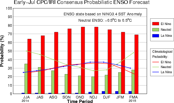
Climate Prediction Center July update of 7/10/14
No big change from past monthly updates in terms of the probabilties.
CLIMATE PREDICTION CENTER/NCEP/NWS
and the International Research Institute for Climate and Society
10 July 2014
ENSO Alert System Status: El Niño Watch
Synopsis: The chance of El Niño is about 70% during the Northern Hemisphere summer and is close to 80% during the fall and early winter.
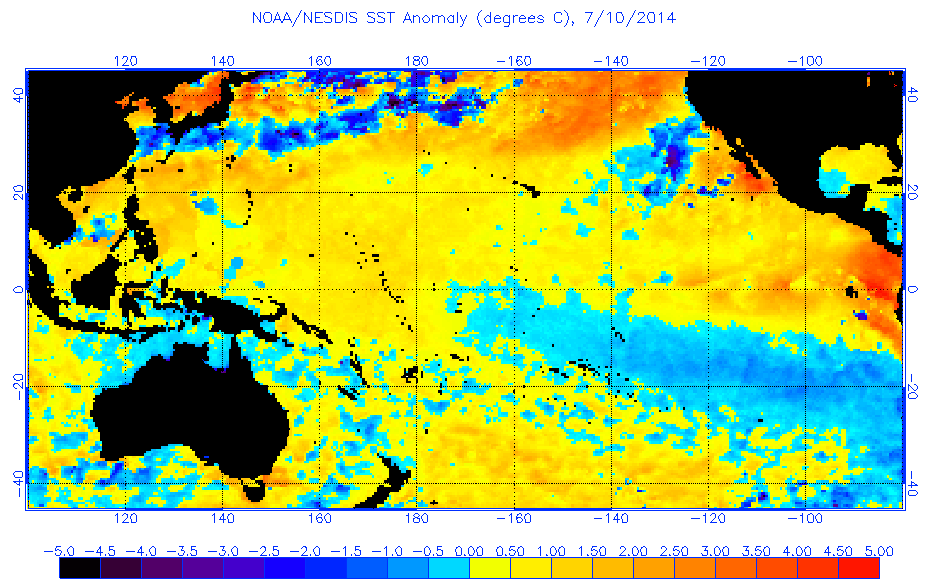
During June 2014, above-average sea surface temperatures (SST) were most prominent in the eastern equatorial Pacific, with weakening evident near the International Date Line (Fig. 1). This weakening was reflected in a decrease to +0.3oC in the Niño-4 index (Fig. 2). The Niño-3.4 index remained around +0.5oC throughout the month, while the easternmost Niño-3 and Niño-1+2 indices are +1.0oC or greater. Subsurface heat content anomalies (averaged between 180o-100oW) have decreased substantially since late March 2014 and are now near average (Fig. 3). However, above-average subsurface temperatures remain prevalent near the surface (down to 100m depth) in the eastern half of the Pacific (Fig. 4). The upper-level and low-level winds over the tropical Pacific remained near average, except for low-level westerly anomalies over the eastern Pacific. Convection was enhanced near and just west of the Date Line and over portions of Indonesia (Fig. 5). Still, the lack of a clear and consistent atmospheric response to the positive SSTs indicates ENSO-neutral.
Over the last month, no significant change was evident in the model forecasts of ENSO, with the majority of models indicating El Niño onset within June-August and continuing into early 2015 (Fig. 6). The chance of a strong El Niño is not favored in any of the ensemble averages for Niño-3.4. At this time, the forecasters anticipate El Niño will peak at weak-to-moderate strength during the late fall and early winter (3-month values of the Niño-3.4 index between 0.5oC and 1.4oC). The chance of El Niño is about 70% during the Northern Hemisphere summer and is close to 80% during the fall and early winter (click CPC/IRI consensus forecast for the chance of each outcome).
http://www.cpc.ncep.noaa.gov/products/a ... odisc.html
No big change from past monthly updates in terms of the probabilties.
CLIMATE PREDICTION CENTER/NCEP/NWS
and the International Research Institute for Climate and Society
10 July 2014
ENSO Alert System Status: El Niño Watch
Synopsis: The chance of El Niño is about 70% during the Northern Hemisphere summer and is close to 80% during the fall and early winter.
During June 2014, above-average sea surface temperatures (SST) were most prominent in the eastern equatorial Pacific, with weakening evident near the International Date Line (Fig. 1). This weakening was reflected in a decrease to +0.3oC in the Niño-4 index (Fig. 2). The Niño-3.4 index remained around +0.5oC throughout the month, while the easternmost Niño-3 and Niño-1+2 indices are +1.0oC or greater. Subsurface heat content anomalies (averaged between 180o-100oW) have decreased substantially since late March 2014 and are now near average (Fig. 3). However, above-average subsurface temperatures remain prevalent near the surface (down to 100m depth) in the eastern half of the Pacific (Fig. 4). The upper-level and low-level winds over the tropical Pacific remained near average, except for low-level westerly anomalies over the eastern Pacific. Convection was enhanced near and just west of the Date Line and over portions of Indonesia (Fig. 5). Still, the lack of a clear and consistent atmospheric response to the positive SSTs indicates ENSO-neutral.
Over the last month, no significant change was evident in the model forecasts of ENSO, with the majority of models indicating El Niño onset within June-August and continuing into early 2015 (Fig. 6). The chance of a strong El Niño is not favored in any of the ensemble averages for Niño-3.4. At this time, the forecasters anticipate El Niño will peak at weak-to-moderate strength during the late fall and early winter (3-month values of the Niño-3.4 index between 0.5oC and 1.4oC). The chance of El Niño is about 70% during the Northern Hemisphere summer and is close to 80% during the fall and early winter (click CPC/IRI consensus forecast for the chance of each outcome).
http://www.cpc.ncep.noaa.gov/products/a ... odisc.html
0 likes
Visit the Caribbean-Central America Weather Thread where you can find at first post web cams,radars
and observations from Caribbean basin members Click Here
and observations from Caribbean basin members Click Here
Re: CPC July update=70% El Nino by Summer/80% by Fall/Winter
Nino 3.4 does indeed looks very neutral this week.
0 likes
-
Kingarabian
- S2K Supporter
- Posts: 16364
- Joined: Sat Aug 08, 2009 3:06 am
- Location: Honolulu, Hawaii
-
Hurricaneman

- Category 5
- Posts: 7404
- Age: 45
- Joined: Tue Aug 31, 2004 3:24 pm
- Location: central florida
Re: CPC July update=70% El Nino by Summer/80% by Fall/Winter
I think its going to one of those better late than never El Ninos that doesn't get reinforcement until sometime in October and then I still only believe a Weak to moderate El Nino is going to happen at best
The posts in this forum are NOT official forecast and should not be used as such. They are just the opinion of the poster and may or may not be backed by sound meteorological data. They are NOT endorsed by any professional institution or storm2k.org. For official information, please refer to the NHC and NWS products
The posts in this forum are NOT official forecast and should not be used as such. They are just the opinion of the poster and may or may not be backed by sound meteorological data. They are NOT endorsed by any professional institution or storm2k.org. For official information, please refer to the NHC and NWS products
0 likes
Re:
Kingarabian wrote:Wait, holdup.
So we're not supposed to put too much stock in satellite readings if they show too much warming, yet we're allowed to instantly believe them when they show massive and un-orthodox cooling?
That Levi graph is crazy. Something isn't right. Shame that we're in 2014 and we can't get decent observations from the buoys and satellites.
Your point is valid. No, we absolutely shouldn't as far as I'm concerned.
0 likes
Personal Forecast Disclaimer:
The posts in this forum are NOT official forecasts and should not be used as such. They are just the opinion of the poster and may or may not be backed by sound meteorological data. They are NOT endorsed by any professional institution or storm2k.org. For official information, please refer to the NHC and NWS products.
The posts in this forum are NOT official forecasts and should not be used as such. They are just the opinion of the poster and may or may not be backed by sound meteorological data. They are NOT endorsed by any professional institution or storm2k.org. For official information, please refer to the NHC and NWS products.
-
WeatherGuesser
- Category 5
- Posts: 2672
- Joined: Tue Jun 29, 2010 6:46 am
-
cycloneye
- Admin
- Posts: 149450
- Age: 69
- Joined: Thu Oct 10, 2002 10:54 am
- Location: San Juan, Puerto Rico
Re: ENSO Updates
Let's see if the new Kelvin Wave/MJO activity propagating eastward warm things in the next few weeks.
The amplitude of the Wheeler-Hendon RMM MJO Index increased during the past several days, with the enhanced convective phase propagating rapidly over the Maritime Continent, suggestive of Kelvin Wave activity. Dynamical models are in better agreement favoring the potential for this activity to evolve into a lower frequency subseasonal mode more consistent with MJO activity over the West Pacific.
http://www.cpc.ncep.noaa.gov/products/p ... /ghazards/
0 likes
Visit the Caribbean-Central America Weather Thread where you can find at first post web cams,radars
and observations from Caribbean basin members Click Here
and observations from Caribbean basin members Click Here
Who is online
Users browsing this forum: No registered users and 128 guests