WPAC: RAMMASUN - Post-Tropical

Moderator: S2k Moderators

Message
Author
User avatar
cycloneye
Admin
Admin
Posts: 145299
Age: 68
Joined: Thu Oct 10, 2002 10:54 am
Location: San Juan, Puerto Rico

Re: WPAC: RAMMASUN - Typhoon

#341 Postby cycloneye » Mon Jul 14, 2014 6:09 pm

UW - CIMSS
ADVANCED DVORAK TECHNIQUE
ADT-Version 8.2.1
Tropical Cyclone Intensity Algorithm

----- Current Analysis -----
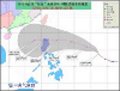
Date : 14 JUL 2014 Time : 220000 UTC
Lat : 12:52:26 N Lon : 125:57:15 E


CI# /Pressure/ Vmax
4.8 / 974.0mb/ 84.8kt


Final T# Adj T# Raw T#
4.8 4.8 4.2

Center Temp : -69.7C Cloud Region Temp : -78.7C

Scene Type : UNIFORM CDO CLOUD REGION w/ MW EYE

Positioning Method : SPIRAL ANALYSIS

Ocean Basin : WEST PACIFIC
Dvorak CI > MSLP Conversion Used : PACIFIC

Tno/CI Rules : Constraint Limits : MW ON
Weakening Flag : OFF
Rapid Dissipation Flag : OFF

Image
0 likes   
Visit the Caribbean-Central America Weather Thread where you can find at first post web cams,radars
and observations from Caribbean basin members Click Here

Alyono
Professional-Met
Professional-Met
Posts: 6961
Joined: Fri Apr 26, 2013 3:52 pm
Location: Texas Coast

#342 Postby Alyono » Mon Jul 14, 2014 7:13 pm

looking at microwave passes, this has just finished an EWRC. May intensify quite a bit before striking the Philippines
0 likes   

dexterlabio
Category 5
Category 5
Posts: 3468
Joined: Sat Oct 24, 2009 11:50 pm

Re: WPAC: RAMMASUN - Typhoon

#343 Postby dexterlabio » Mon Jul 14, 2014 7:31 pm

Image


Eye has taken a smaller form. Also quite evident now in visible imagery, just off the northeastern coast of Samar island.
0 likes   
Personal Forecast Disclaimer:
The posts in this forum are NOT official forecast and should not be used as such. They are just the opinion of the poster and may or may not be backed by sound meteorological data. They are NOT endorsed by any professional institution or storm2k.org. For official information, please refer to the NHC and NWS products.

User avatar
cycloneye
Admin
Admin
Posts: 145299
Age: 68
Joined: Thu Oct 10, 2002 10:54 am
Location: San Juan, Puerto Rico

Re: WPAC: RAMMASUN - Typhoon

#344 Postby cycloneye » Mon Jul 14, 2014 7:40 pm

Radar image is impressive. This is from the Philippines weather thread.

viewtopic.php?f=3&t=115085&hilit=&p=2392465#p2392465
0 likes   
Visit the Caribbean-Central America Weather Thread where you can find at first post web cams,radars
and observations from Caribbean basin members Click Here

User avatar
cycloneye
Admin
Admin
Posts: 145299
Age: 68
Joined: Thu Oct 10, 2002 10:54 am
Location: San Juan, Puerto Rico

Re: WPAC: RAMMASUN - Typhoon

#345 Postby cycloneye » Mon Jul 14, 2014 7:52 pm

00z Best Track at 80kts.

09W RAMMASUN 140715 0000 12.8N 125.6E WPAC 80 963
0 likes   
Visit the Caribbean-Central America Weather Thread where you can find at first post web cams,radars
and observations from Caribbean basin members Click Here

User avatar
cycloneye
Admin
Admin
Posts: 145299
Age: 68
Joined: Thu Oct 10, 2002 10:54 am
Location: San Juan, Puerto Rico

Re: WPAC: RAMMASUN - Typhoon

#346 Postby cycloneye » Mon Jul 14, 2014 8:10 pm

JMA warning.
TY 1409 (RAMMASUN)
Issued at 00:50 UTC, 15 July 2014
<Analyses at 15/00 UTC>
Scale -
Intensity Strong
Center position N12°40'(12.7°)
E125°35'(125.6°)
Direction and speed of movement W 25km/h(13kt)
Central pressure 970hPa
Maximum wind speed near the center 35m/s(70kt)
Maximum wind gust speed 50m/s(100kt)
Area of 50kt winds or more ALL90km(50NM)
Area of 30kt winds or more ALL260km(140NM)

<Forecast for 15/12 UTC>
Intensity Strong
Center position of probability circle N13°10'(13.2°)
E123°40'(123.7°)
Direction and speed of movement WNW 20km/h(10kt)
Central pressure 970hPa
Maximum wind speed near the center 35m/s(70kt)
Maximum wind gust speed 50m/s(100kt)
Radius of probability circle 90km(50NM)
Storm warning area ALL190km(100NM)

<Forecast for 16/00 UTC>
Intensity Strong
Center position of probability circle N14°20'(14.3°)
E121°55'(121.9°)
Direction and speed of movement WNW 20km/h(10kt)
Central pressure 975hPa
Maximum wind speed near the center 35m/s(65kt)
Maximum wind gust speed 50m/s(95kt)
Radius of probability circle 130km(70NM)
Storm warning area ALL220km(120NM)

<Forecast for 17/00 UTC>
Intensity -
Center position of probability circle N17°05'(17.1°)
E117°10'(117.2°)
Direction and speed of movement WNW 25km/h(13kt)
Central pressure 975hPa
Maximum wind speed near the center 30m/s(60kt)
Maximum wind gust speed 45m/s(85kt)
Radius of probability circle 260km(140NM)
Storm warning area ALL330km(180NM)

<Forecast for 18/00 UTC>
Intensity -
Center position of probability circle N18°50'(18.8°)
E112°50'(112.8°)
Direction and speed of movement WNW 20km/h(11kt)
Central pressure 975hPa
Maximum wind speed near the center 30m/s(60kt)
Maximum wind gust speed 45m/s(85kt)
Radius of probability circle 390km(210NM)
Storm warning area ALL460km(250NM)
0 likes   
Visit the Caribbean-Central America Weather Thread where you can find at first post web cams,radars
and observations from Caribbean basin members Click Here

User avatar
cycloneye
Admin
Admin
Posts: 145299
Age: 68
Joined: Thu Oct 10, 2002 10:54 am
Location: San Juan, Puerto Rico

Re: WPAC: RAMMASUN - Typhoon

#347 Postby cycloneye » Mon Jul 14, 2014 8:34 pm

JTWC 03:00z warning.

Image
0 likes   
Visit the Caribbean-Central America Weather Thread where you can find at first post web cams,radars
and observations from Caribbean basin members Click Here

dexterlabio
Category 5
Category 5
Posts: 3468
Joined: Sat Oct 24, 2009 11:50 pm

Re: WPAC: RAMMASUN - Typhoon

#348 Postby dexterlabio » Mon Jul 14, 2014 8:46 pm

Rammasun's eye is so small.

Image
0 likes   
Personal Forecast Disclaimer:
The posts in this forum are NOT official forecast and should not be used as such. They are just the opinion of the poster and may or may not be backed by sound meteorological data. They are NOT endorsed by any professional institution or storm2k.org. For official information, please refer to the NHC and NWS products.

User avatar
cycloneye
Admin
Admin
Posts: 145299
Age: 68
Joined: Thu Oct 10, 2002 10:54 am
Location: San Juan, Puerto Rico

Re: WPAC: RAMMASUN - Typhoon

#349 Postby cycloneye » Mon Jul 14, 2014 9:15 pm

JTWC 03:00z discussion.

WDPN32 PGTW 150300
MSGID/GENADMIN/JOINT TYPHOON WRNCEN PEARL HARBOR HI//
SUBJ/PROGNOSTIC REASONING FOR TYPHOON 09W (RAMMASUN) WARNING NR 19//
RMKS/
1. FOR METEOROLOGISTS.
2. 6 HOUR SUMMARY AND ANALYSIS.
TYPHOON (TY) 09W (RAMMASUN), LOCATED APPROXIMATELY 289 NM
EAST-SOUTHEAST OF MANILA, PHILIPPINES, HAS TRACKED WESTWARD AT 13
KNOTS OVER THE PAST SIX HOURS. ANIMATED MULTISPECTRAL SATELLITE
IMAGERY (MSI) SHOWS TY 09W HAS MAINTAINED ITS DEGREE OF WRAP AND
CONVECTIVE DEPTH AS ITS 10-NM EYE, FILLED WITH THIN CIRRUS, HAS
RE-EMERGED. THE INITIAL POSITION IS BASED ON THE MSI ANIMATION WITH
HIGH CONFIDENCE. THE INITIAL INTENSITY IS BASED ON CONGRUENT DVORAK
ESTIMATES FROM PGTW, KNES, AND RJTD. UPPER LEVEL ANALYSIS REVEALS A
FAVORABLE ENVIRONMENT AS VIGOROUS EQUATORWARD AND WESTWARD OUTFLOW
CONTINUE WHILE VERTICAL WIND SHEAR ARE AT LOW (05 TO 10 KNOT) LEVELS.
TY 09W REMAINS ON A GENERALLY WESTWARD TRACK ALONG THE SOUTHERN
PERIPHERY OF A DEEP-LAYERED SUBTROPICAL RIDGE (STR) TO THE NORTH.
3. FORECAST REASONING.
A. NO CHANGE TO THE FORECAST PHILOSOPHY SINCE THE PREVIOUS
PROGNOSTIC REASONING MESSAGE.
B. TY 09W IS FORECAST TO TRACK ON A MORE WEST-NORTHWESTWARD
TRAJECTORY AS A TRANSITORY MID-LATITUDE TROUGH DIGGING IN FROM
MONGOLIA WEAKENS THE STEERING STR. THE TYPHOON IS EXPECTED TO MAKE
LANDFALL JUST NORTH OF SORSOGON, PHILIPPINES, IN SIX HOURS.
AFTERWARDS, AS THE SYSTEM DRAGS ACROSS SOUTHERN LUZON AND INTO
MANILA, IT WILL WEAKEN DUE TO FRICTIONAL EFFECTS BUT WILL RE-EMERGE
IN THE SOUTH CHINA SEA (SCS) OVER SUBIC BAY SHORTLY AFTER TAU 30 AS A
STRONG TROPICAL STORM. WARM SST IN THE SCS PLUS CONTINUED FAVORABLE
UPPER LEVEL CONDITIONS WILL FAVOR RAPID RE-INTENSIFICATION, PEAKING
AT 90 KNOTS BY TAU 72.
C. IN THE EXTENDED TAUS, TYPHOON RAMMASUN IS FORECAST TO CONTINUE
NORTHWESTWARD ACROSS THE SOUTH CHINA SEA MAKING A SECONDARY LANDFALL
OVER NORTHERN HAINAN NEAR TAU 84. IT WILL THEN CROSS THE GULF OF
TONKIN AND MAKE A FINAL LANDFALL OVER NORTHERN VIETNAM NEAR HANOI.
LAND INTERACTION WILL PRIMARILY CAUSE ITS WEAKENING; HOWEVER,
RAMMASUN WILL MAINTAIN A SOLID 80-KNOT TYPHOON INTENSITY BEFORE ITS
FINAL LANDFALL. DUE TO THE OVERALL GOOD AGREEMENT IN THE MODELS,
THERE IS HIGH CONFIDENCE IN THE FORECAST TRACK. HOWEVER, THERE IS
SOME UNCERTAINTY IN THE EXTENDED INTENSITY FORECAST WHICH IS
DEPENDENT ON THE EXTENT OF THE WEAKENING CAUSED BY LAND INTERACTION
IN THE INITIAL PORTION OF THE FORECAST.//
NNNN
0 likes   
Visit the Caribbean-Central America Weather Thread where you can find at first post web cams,radars
and observations from Caribbean basin members Click Here

euro6208

Re: WPAC: RAMMASUN - Typhoon

#350 Postby euro6208 » Mon Jul 14, 2014 9:41 pm

4.5 from PGTW and KNES...

I think maybe 80 knots is a bit low maybe 85-90 knots given the small eye...
0 likes   

CrazyC83
Professional-Met
Professional-Met
Posts: 34002
Joined: Tue Mar 07, 2006 11:57 pm
Location: Deep South, for the first time!

#351 Postby CrazyC83 » Mon Jul 14, 2014 10:45 pm

Looks like landfall right now, based on radar images, in extreme NE Visayas.

I'd put the landfall intensity at 85 kt.
0 likes   

dexterlabio
Category 5
Category 5
Posts: 3468
Joined: Sat Oct 24, 2009 11:50 pm

Re: WPAC: RAMMASUN - Typhoon

#352 Postby dexterlabio » Mon Jul 14, 2014 10:57 pm

The developing eye skirted the northern coast by just a few kilometers. Could be considered as landfall though. The eye has just started clearing out. DT numbers are going up.


TPPN11 PGTW 150323

A. TYPHOON 09W (RAMMASUN)

B. 15/0232Z

C. 12.8N

D. 125.2E

E. THREE/MTSAT

F. T5.0/5.0/D1.0/24HRS STT: D0.5/03HRS

G. IR/EIR/VIS/MSI

H. REMARKS: 11A/PBO RAGGED EYE/ANMTN. LG EYE SURROUNDED BY W
YIELDS AN E# AND DT (NO EYE ADJUSTMENT) OF 6.0. MET AND PT
YIELD A 5.0. DBO MET.

I. ADDITIONAL POSITIONS:
14/2131Z 12.7N 126.3E WIND
14/2201Z 12.7N 126.0E SSMS
14/2321Z 12.7N 125.7E SSMS


CHAPPOTIN
0 likes   
Personal Forecast Disclaimer:
The posts in this forum are NOT official forecast and should not be used as such. They are just the opinion of the poster and may or may not be backed by sound meteorological data. They are NOT endorsed by any professional institution or storm2k.org. For official information, please refer to the NHC and NWS products.

CrazyC83
Professional-Met
Professional-Met
Posts: 34002
Joined: Tue Mar 07, 2006 11:57 pm
Location: Deep South, for the first time!

#353 Postby CrazyC83 » Mon Jul 14, 2014 11:15 pm

Yeah probably skirted back offshore. Agreed probably a solid Cat 2 now.
0 likes   

User avatar
climateconcern23
Tropical Low
Tropical Low
Posts: 35
Age: 34
Joined: Sat Mar 05, 2011 4:38 am
Location: Philippines
Contact:

#354 Postby climateconcern23 » Mon Jul 14, 2014 11:16 pm

The eye is getting bigger and more visible on latest MSAT- Floater. A Cat TY 3 before landfall? :eek:
0 likes   

euro6208

Re: WPAC: RAMMASUN - Typhoon

#355 Postby euro6208 » Mon Jul 14, 2014 11:20 pm

It is intensifying rapidly now PGTW and KNES up to 5.0 and 5.5. If it continues , JTWC might increase to a major typhoon, Cat 3!
0 likes   

CrazyC83
Professional-Met
Professional-Met
Posts: 34002
Joined: Tue Mar 07, 2006 11:57 pm
Location: Deep South, for the first time!

#356 Postby CrazyC83 » Tue Jul 15, 2014 12:45 am

TXPQ28 KNES 150350
TCSWNP

A. 09W (RAMMASUN)

B. 15/0232Z

C. 12.8N

D. 125.2E

E. ONE/MTSAT

F. T5.5/5.5/D1.5/24HRS

G. IR/EIR/VIS/WINDSAT/SSMIS

H. REMARKS...DT OF 5.5 IS BASED ON LG EYE SURROUNDED BY W AND EMBEDDED
IN W, AFTER A 0 EYE ADJUSTMENT AND A 0.5 SUBTRACTION FOR ELONGATION OF
THE WARMEST PIXELS. MET AND PT ARE 5.0. FT IS BASED ON DT.

I. ADDL POSITIONS

14/2131Z 12.6N 126.3E WINDSAT
14/2321Z 12.8N 125.7E SSMIS


...RAMIREZ
0 likes   

HurricaneTracker2031
Tropical Storm
Tropical Storm
Posts: 248
Age: 25
Joined: Fri Jul 19, 2013 7:20 pm
Location: Pembroke Pines, FL, USA
Contact:

Re: WPAC: RAMMASUN - Typhoon

#357 Postby HurricaneTracker2031 » Tue Jul 15, 2014 12:52 am

Rammasun looks very nice and might intensify prior to landfall. 130mph?

Image

Synopsis of Western Pacific and other Basins: http://goo.gl/9XrmSW

Personal Forecast Disclaimer:
The posts in this forum are NOT official forecast and should not be used as such. They are just the opinion of the poster and may or may not be backed by sound meteorological data. They are NOT endorsed by any professional institution or storm2k.org. For official information, please refer to the NHC and NWS products.[
0 likes   
SHORT VERSION OF DISCLAIMER: THIS SITE LINK BELOW IS NOT AN OFFICIAL FORECASTING OFFICE AND SHOULD NOT BE USED TO MAKE ANY EMERGENCY DECISIONS....

http://www.macstropicalweather.weebly.com

dexterlabio
Category 5
Category 5
Posts: 3468
Joined: Sat Oct 24, 2009 11:50 pm

Re: WPAC: RAMMASUN - Typhoon

#358 Postby dexterlabio » Tue Jul 15, 2014 12:55 am

100-105 knots isn't a far-fetched estimate, is it?

Image


It's been 8 years since a major cyclone has made landfall in the Bicol region (Xangxane and Durian).
Last edited by dexterlabio on Tue Jul 15, 2014 12:57 am, edited 1 time in total.
0 likes   
Personal Forecast Disclaimer:
The posts in this forum are NOT official forecast and should not be used as such. They are just the opinion of the poster and may or may not be backed by sound meteorological data. They are NOT endorsed by any professional institution or storm2k.org. For official information, please refer to the NHC and NWS products.

dexterlabio
Category 5
Category 5
Posts: 3468
Joined: Sat Oct 24, 2009 11:50 pm

#359 Postby dexterlabio » Tue Jul 15, 2014 12:56 am

This actually looks better than TY Nari which made landfall in Luzon last year as a Cat3.
0 likes   
Personal Forecast Disclaimer:
The posts in this forum are NOT official forecast and should not be used as such. They are just the opinion of the poster and may or may not be backed by sound meteorological data. They are NOT endorsed by any professional institution or storm2k.org. For official information, please refer to the NHC and NWS products.

ejeraldmc
Tropical Storm
Tropical Storm
Posts: 121
Joined: Thu Oct 14, 2010 6:27 pm
Location: Batangas

#360 Postby ejeraldmc » Tue Jul 15, 2014 1:20 am

Torrential rain here in Batangas :eek:
0 likes   
The above post is not official and should not be used as such. It is the opinion of the poster and may or may not be backed by sound meteorological data. It is not endorsed by any professional institution or storm2k.org. For official information, please refer to the NHC and NWS products.


Return to “2014”

Who is online

Users browsing this forum: No registered users and 1 guest