
TPPN11 PGTW 150618
A. TYPHOON 09W (RAMMASUN)
B. 15/0532Z
C. 13.0N
D. 124.7E
E. THREE/MTSAT
F. T5.5/5.5/D1.5/24HRS STT: D0.5/03HRS
G. IR/EIR/VIS/MSI
H. REMARKS: 11A/PBO RAGGED EYE/ANMTN. MG EYE SURROUNDED BY B
YIELDS AN E# AND DT (NO EYE ADJUSTMENT) OF 5.5. MET AND PT
AGREE WITH DT. DBO DT.
I. ADDITIONAL POSITIONS:
15/0044Z 12.8N 125.5E MMHS
15/0137Z 12.7N 125.5E MMHS
LONG
WPAC: RAMMASUN - Post-Tropical
Moderator: S2k Moderators
-
dexterlabio
- Category 5

- Posts: 3509
- Joined: Sat Oct 24, 2009 11:50 pm
I expect a Category 3 typhoon from JTWC in their next warning. JMA might also increase the intensity, the eye has developed really quickly since the previous warnings from agencies...
0 likes
Personal Forecast Disclaimer:
The posts in this forum are NOT official forecast and should not be used as such. They are just the opinion of the poster and may or may not be backed by sound meteorological data. They are NOT endorsed by any professional institution or storm2k.org. For official information, please refer to the NHC and NWS products.
The posts in this forum are NOT official forecast and should not be used as such. They are just the opinion of the poster and may or may not be backed by sound meteorological data. They are NOT endorsed by any professional institution or storm2k.org. For official information, please refer to the NHC and NWS products.
-
ManilaTC

- WesternPacificWeather.com

- Posts: 593
- Age: 47
- Joined: Mon Oct 26, 2009 5:13 am
- Location: Mandaluyong City, Philippines
- Contact:
09W RAMMASUN 140715 0600 13.0N 124.7E WPAC 100 948
100 KTS!!! CATEGORY 3!!!
100 KTS!!! CATEGORY 3!!!
0 likes
The above post is NOT official and should not be used as such. It is my opinion and may or may not be backed by sound meteorological data. It is not endorsed by any professional institution or storm2k.org. Please refer to your official national weather agency.
WEB http://goo.gl/JDiKXB | FB https://goo.gl/N5sIle | @ManilaTC
WEB http://goo.gl/JDiKXB | FB https://goo.gl/N5sIle | @ManilaTC
WTPQ21 RJTD 150600
RSMC TROPICAL CYCLONE ADVISORY
NAME TY 1409 RAMMASUN (1409)
ANALYSIS
PSTN 150600UTC 12.9N 124.7E GOOD
MOVE W 12KT
PRES 965HPA
MXWD 075KT
GUST 105KT
50KT 50NM
30KT 150NM
FORECAST
24HF 160600UTC 14.9N 121.0E 75NM 70%
MOVE NW 11KT
PRES 970HPA
MXWD 070KT
GUST 100KT
48HF 170600UTC 17.5N 116.1E 140NM 70%
MOVE WNW 13KT
PRES 975HPA
MXWD 060KT
GUST 085KT
72HF 180600UTC 19.1N 111.9E 210NM 70%
MOVE WNW 11KT
PRES 975HPA
MXWD 060KT
GUST 085KT =
0 likes
-
euro6208
Re: WPAC: RAMMASUN - Typhoon
09W RAMMASUN 140715 0600 13.0N 124.7E WPAC 100 948
Wow Category 3 Major typhoon
Wow Category 3 Major typhoon
0 likes

-
euro6208
Re: WPAC: RAMMASUN - Typhoon
ADT showing much stronger, solid 5.9 or 110 knots!
2014JUL15 053200 5.9 952.0 112.4 5.9 5.9 5.9 NO LIMIT OFF OFF -38.08 -71.75 EYE -99 IR 76.7 12.95 -124.69 COMBO MTSAT2 28.0
2014JUL15 053200 5.9 952.0 112.4 5.9 5.9 5.9 NO LIMIT OFF OFF -38.08 -71.75 EYE -99 IR 76.7 12.95 -124.69 COMBO MTSAT2 28.0
0 likes
-
ManilaTC
- WesternPacificWeather.com
- Posts: 593
- Age: 47
- Joined: Mon Oct 26, 2009 5:13 am
- Location: Mandaluyong City, Philippines
- Contact:
Re: WPAC: RAMMASUN - Typhoon
Now starting to make landfall in the NE tip of Sorsogon near Gubat town on the way to Legaspi City.
0 likes
The above post is NOT official and should not be used as such. It is my opinion and may or may not be backed by sound meteorological data. It is not endorsed by any professional institution or storm2k.org. Please refer to your official national weather agency.
WEB http://goo.gl/JDiKXB | FB https://goo.gl/N5sIle | @ManilaTC
WEB http://goo.gl/JDiKXB | FB https://goo.gl/N5sIle | @ManilaTC
-
Filipinas50
- Tropical Depression

- Posts: 77
- Age: 60
- Joined: Tue May 28, 2013 2:07 am
- Location: Planet Earth
Re: WPAC: RAMMASUN - Typhoon
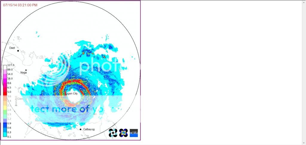
Eyewall of Typhoon Rammasun (Glenda) While Approaching the Coastline of Albay Province this Afternoon ...
(Image:PAGASA Virac Doppler Radar Station)
(Image:PAGASA Virac Doppler Radar Station)
0 likes
RETIRED FROM THE 9-5 RAT RACE

-
dexterlabio
- Category 5
- Posts: 3509
- Joined: Sat Oct 24, 2009 11:50 pm
Re:
dhoeze wrote:Did the track moved more to the south? Eye will pass South of Metro Manila or Cavite Laguna?
If it does move more west than north, then yes. Similar to Xangxane's track in 2006.
0 likes
Personal Forecast Disclaimer:
The posts in this forum are NOT official forecast and should not be used as such. They are just the opinion of the poster and may or may not be backed by sound meteorological data. They are NOT endorsed by any professional institution or storm2k.org. For official information, please refer to the NHC and NWS products.
The posts in this forum are NOT official forecast and should not be used as such. They are just the opinion of the poster and may or may not be backed by sound meteorological data. They are NOT endorsed by any professional institution or storm2k.org. For official information, please refer to the NHC and NWS products.
-
euro6208
Re: WPAC: RAMMASUN - Typhoon
Very impressive but scary discussion.
WDPN32 PGTW 150900
MSGID/GENADMIN/JOINT TYPHOON WRNCEN PEARL HARBOR HI//
SUBJ/PROGNOSTIC REASONING FOR TYPHOON 09W (RAMMASUN) WARNING NR 20//
RMKS/
1. FOR METEOROLOGISTS.
2. 6 HOUR SUMMARY AND ANALYSIS.
TYPHOON 09W (RAMMASUN), LOCATED APPROXIMATELY 236 NM EAST-
SOUTHEAST OF MANILA, PHILIPPINES, HAS TRACKED WEST-NORTHWESTWARD AT
09 KNOTS OVER THE PAST SIX HOURS. THE CURRENT POSITION IS BASED ON A
HIGH CONFIDENCE SATELLITE EYE FIX ON A CLEAR, 20 NM DIAMETER EYE NOW
EVIDENT IN THE MULTISPECTRAL AND 150609Z TRMM MICROWAVE IMAGERY. THE
INITIAL INTENSITY HAS INCREASED TO 100 KNOTS BASED ON CONSISTENT
DVORAK ESTIMATES FROM PGTW, KNES, AND RJTD. UPPER-LEVEL ANALYSIS
INDICATES TY 09W REMAINS IN FAVORABLE ENVIRONMENT WITH LOW (05 TO 10
KNOT) VERTICAL WIND SHEAR (VWS) AND VIGOROUS POLEWARD AND WESTWARD
OUTFLOW. TY 09W IS CLOSING IN ON THE ISLAND OF SORSOGON, PHILIPPINES
AS IT TRACKS WESTWARD ALONG THE SOUTHERN PERIPHERY OF A DEEP-LAYERED
SUBTROPICAL RIDGE (STR) TO THE NORTH.
3. FORECAST REASONING.
A. FORECAST INTENSITIES HAVE INCREASED BASED ON THE CURRENT RAPID
INTENSIFICATION TREND AND EXPECTATIONS OF FAVORABLE CONDITIONS THAT
ARE EXPECTED TO PERSIST UNTIL THE SYSTEM MAKES LANDFALL IN SORSOGON.
B. TY 09W IS FORECAST TO TRACK ON A MORE WEST-NORTHWESTWARD OVER
THE NEXT 12 HOURS UNDER THE STEERING INFLUENCE OF THE STR. THE
TYPHOON WILL TURN SLIGHTLY MORE POLEWARD AFTER TAU 12 AS IT
ENCOUNTERS A WEAKNESS IN THE STR INDUCED BY A SHORTWAVE TROUGH
PASSING OVER EASTERN CHINA. TYPHOON RAMMASUN WILL WEAKEN
CONSIDERABLY AS IT TRACKS ACROSS SOUTHERN LUZON AND INTO MANILA OVER
THE NEXT 24 HOURS. HOWEVER, TY 09W IS EXPECTED TO REINTENSIFY AFTER
REEMERGING OVER THE SOUTH CHINA SEA (SCS) TO A CONTINUATION OF THE
AFOREMENTIONED FAVORABLE ENVIRONMENT. WARM SST IN THE SCS PLUS
CONTINUED FAVORABLE UPPER LEVEL CONDITIONS WILL FAVOR RAPID RE-
INTENSIFICATION, PEAKING AT 105 KNOTS BY TAU 72.
C. IN THE EXTENDED TAUS, TYPHOON RAMMASUN IS FORECAST TO TRACK
NORTHWESTWARD ACROSS THE SOUTH CHINA SEA MAKING A SECONDARY LANDFALL
OVER NORTHERN HAINAN NEAR TAU 84. IT WILL THEN CROSS THE GULF OF
TONKIN AND MAKE A FINAL LANDFALL OVER NORTHERN VIETNAM NEAR HANOI.
LAND INTERACTION WILL PRIMARILY CAUSE ITS WEAKENING; HOWEVER, TY 09W
WILL MAINTAIN A SOLID 90-KNOT TYPHOON INTENSITY BEFORE ITS FINAL
LANDFALL INTO NORTHERN VIETNAM. AVAILABLE MODEL GUIDANCE IS IN TIGHT
AGREEMENT, LENDING HIGH CONFIDENCE IN THE FORECAST TRACK. HOWEVER,
THERE IS UNCERTAINTY IN THE EXTENDED INTENSITY FORECAST WHICH IS
DEPENDENT ON THE EXTENT OF THE WEAKENING CAUSED BY LAND INTERACTION
IN THE INITIAL PORTION OF THE FORECAST. THEREFORE, THERE IS OVERALL
LOW CONFIDENCE IN THE JTWC FORECAST.//
NNNN
0 likes
-
euro6208
Re: WPAC: RAMMASUN - Typhoon
5.9 950.0 112.4 5.9 6.5 6.6 1.7T/6hr
Massive increase Adj and Ini up to 6.5 and 6.6!
Massive increase Adj and Ini up to 6.5 and 6.6!
0 likes
-
jaguarjace

- Category 4

- Posts: 975
- Age: 31
- Joined: Sat Jun 11, 2011 7:38 am
- Location: Khon Kaen, Thailand
Re: WPAC: RAMMASUN - Typhoon
Close-up floater.

0 likes
Owner of the Tropical Archive YouTube channel
Web Developer at Force Thirteen
Twitter/X : @force13_support
Web Developer at Force Thirteen
Twitter/X : @force13_support
-
euro6208
Re: WPAC: RAMMASUN - Typhoon
It's moving to the west northwest which would likely place the eye much longer over water. Category 4 shouldn't be ruled out yet.
0 likes
-
ManilaTC
- WesternPacificWeather.com
- Posts: 593
- Age: 47
- Joined: Mon Oct 26, 2009 5:13 am
- Location: Mandaluyong City, Philippines
- Contact:
Re: WPAC: RAMMASUN - Typhoon
Just saw a tweet saying James Reynolds made it to Legaspi City, and that area is now 2-3 hours away from the right front eyewall.
Radar image from Virac shows eye clipping NE of Sorsogon Peninsula near Gubat town

Radar image from Virac shows eye clipping NE of Sorsogon Peninsula near Gubat town
0 likes
The above post is NOT official and should not be used as such. It is my opinion and may or may not be backed by sound meteorological data. It is not endorsed by any professional institution or storm2k.org. Please refer to your official national weather agency.
WEB http://goo.gl/JDiKXB | FB https://goo.gl/N5sIle | @ManilaTC
WEB http://goo.gl/JDiKXB | FB https://goo.gl/N5sIle | @ManilaTC
Re: WPAC: RAMMASUN - Typhoon

0 likes
The above post is not official and should not be used as such. It is the opinion of the poster and may or may not be backed by sound meteorological data. It is not endorsed by any professional institution or storm2k.org. For official information, please refer to the NHC and NWS products.
-
dexterlabio
- Category 5
- Posts: 3509
- Joined: Sat Oct 24, 2009 11:50 pm
Re: WPAC: RAMMASUN - Typhoon
I was arguing with a weather page owner because the person kept saying that it will weaken to a Cat1 at landfall and won't be a "Xangxane". Well Rammasun just did... It looks like we will have a strong Cat4 typhoon inland...
TPPN11 PGTW 150912
A. TYPHOON 09W (RAMMASUN)
B. 15/0832Z
C. 13.0N
D. 124.3E
E. ONE/MTSAT
F. T6.0/6.0/D2.0/24HRS STT: D0.5/03HRS
G. IR/EIR
H. REMARKS: 05A/PBO IRREG EYE/ANMTN. OW EYE SURROUNDED BY W
YIELDS AN E# OF 6.0. ADDED 0.5 FOR EYE ADJUSTMENT TO YIELD A DT
OF 6.5. MET YIELDS 5.5, PT YIELDS 6.0. DBO PT DUE TO
CONSTRAINTS WITH DT (CHANGE OF 1.0 IN 6 HOURS).
I. ADDITIONAL POSITIONS:
15/0344Z 12.8N 124.8E AMS2
15/0409Z 12.8N 125.0E TRMM
15/0426Z 12.8N 124.9E GPMI
LONG
0 likes
Personal Forecast Disclaimer:
The posts in this forum are NOT official forecast and should not be used as such. They are just the opinion of the poster and may or may not be backed by sound meteorological data. They are NOT endorsed by any professional institution or storm2k.org. For official information, please refer to the NHC and NWS products.
The posts in this forum are NOT official forecast and should not be used as such. They are just the opinion of the poster and may or may not be backed by sound meteorological data. They are NOT endorsed by any professional institution or storm2k.org. For official information, please refer to the NHC and NWS products.
-
xtyphooncyclonex

- Category 5
- Posts: 3891
- Age: 24
- Joined: Sat Dec 08, 2012 9:07 am
- Location: Cebu City
- Contact:
TY 1409 (RAMMASUN)
Issued at 09:40 UTC, 15 July 2014
<Analyses at 15/09 UTC>
Scale -
Intensity Very Strong
Center position N13°05'(13.1°)
E124°05'(124.1°)
Direction and speed of movement W 20km/h(12kt)
Central pressure 945hPa
Maximum wind speed near the center 45m/s(85kt)
Maximum wind gust speed 60m/s(120kt)
Area of 50kt winds or more ALL90km(50NM)
Area of 30kt winds or more ALL280km(150NM)
0 likes
REMINDER: My opinions that I, or any other NON Pro-Met in this forum, are unofficial. Please do not take my opinions as an official forecast and warning. I am NOT a meteorologist. Following my forecasts blindly may lead to false alarm, danger and risk if official forecasts from agencies are ignored.
-
xtyphooncyclonex
- Category 5
- Posts: 3891
- Age: 24
- Joined: Sat Dec 08, 2012 9:07 am
- Location: Cebu City
- Contact:
Wow. Rammasun really reminds me of Xangsane 2006 when it was at a nearly similar position and intensified this fast.
BTW classes in some private schools and ALL public schools in Cebu were suspended at noon time because of the effects Rammasun brought to us here.
BTW classes in some private schools and ALL public schools in Cebu were suspended at noon time because of the effects Rammasun brought to us here.
0 likes
REMINDER: My opinions that I, or any other NON Pro-Met in this forum, are unofficial. Please do not take my opinions as an official forecast and warning. I am NOT a meteorologist. Following my forecasts blindly may lead to false alarm, danger and risk if official forecasts from agencies are ignored.
Who is online
Users browsing this forum: No registered users and 32 guests