Texas Summer - 2014

U.S. & Caribbean Weather Discussions and Severe Weather Events

Moderator: S2k Moderators

Forum rules

The posts in this forum are NOT official forecast and should not be used as such. They are just the opinion of the poster and may or may not be backed by sound meteorological data. They are NOT endorsed by any professional institution or STORM2K.

Help Support Storm2K
Message
Author
User avatar
somethingfunny
ChatStaff
ChatStaff
Posts: 3926
Age: 37
Joined: Thu May 31, 2007 10:30 pm
Location: McKinney, Texas

Re:

#361 Postby somethingfunny » Mon Jul 14, 2014 4:47 pm

WeatherNewbie wrote:Some decent little storms moving into the Metroplex.


Aggghhh!!!! :grr:

I just got totally bypassed by the slimmest of margins.

Image
0 likes   
I am not a meteorologist, and any posts made by me are not official forecasts or to be interpreted as being intelligent. These posts are just my opinions and are probably silly opinions.

User avatar
TheProfessor
Professional-Met
Professional-Met
Posts: 3506
Age: 28
Joined: Tue Dec 03, 2013 10:56 am
Location: Wichita, Kansas

Re: Re:

#362 Postby TheProfessor » Mon Jul 14, 2014 7:22 pm

WeatherNewbie wrote:Some decent little storms moving into the Metroplex.
[/quote]
somethingfunny wrote:Aggghhh!!!! :grr: I just got totally bypassed by the slimmest of margins.
[/quote]


Wow, That just shows you how isolated the storms were, I was blessed to get hit twice today, dropped my temps into the 70s. 8-)
0 likes   
An alumnus of The Ohio State University.

Your local National Weather Service office is your best source for weather information.

User avatar
TheProfessor
Professional-Met
Professional-Met
Posts: 3506
Age: 28
Joined: Tue Dec 03, 2013 10:56 am
Location: Wichita, Kansas

#363 Postby TheProfessor » Mon Jul 14, 2014 7:49 pm

:uarrow: Getting my third shower now, this one is a lot lighter than the other 2, but every drop counts.
0 likes   
An alumnus of The Ohio State University.

Your local National Weather Service office is your best source for weather information.

User avatar
Ptarmigan
Category 5
Category 5
Posts: 5313
Joined: Wed Aug 16, 2006 9:06 pm

Re:

#364 Postby Ptarmigan » Mon Jul 14, 2014 10:01 pm

Ntxw wrote:2011 should be considered profanity :grr:. I can promise nothing like that will happen this year. We were all amidst long streaks of 100 as dhweather said with a putrid winter to boot. Nightmare still haunts...


Summer 2011 is an anomaly. That type of summer is 1 in 10,000 chance it will happen.
0 likes   

User avatar
Ptarmigan
Category 5
Category 5
Posts: 5313
Joined: Wed Aug 16, 2006 9:06 pm

Re: Re:

#365 Postby Ptarmigan » Mon Jul 14, 2014 10:02 pm

South Texas Storms wrote:
Ntxw wrote:How can one not like 1-2 inches in what is the driest, hottest month of the year? I understand the negativity towards forecasts but considering what it should be then better count those blessings rather than not. It could be hot, humid, and huge evaporation.


Yeah, we should be very thankful for whatever we can get during the summer (or anytime of the year for that matter). Any MCS moving through the state can bring several inches of rain to widespread areas. Hopefully we see several of them throughout this week.


Reason why I do not put a lot of stock in weather forecast models. I like to use many as possible.
0 likes   

User avatar
Ntxw
Storm2k Moderator
Storm2k Moderator
Posts: 22784
Joined: Wed Oct 21, 2009 6:34 pm
Location: DFW, Texas

Re: Re:

#366 Postby Ntxw » Mon Jul 14, 2014 10:30 pm

Ptarmigan wrote:
Ntxw wrote:2011 should be considered profanity :grr:. I can promise nothing like that will happen this year. We were all amidst long streaks of 100 as dhweather said with a putrid winter to boot. Nightmare still haunts...


Summer 2011 is an anomaly. That type of summer is 1 in 10,000 chance it will happen.


I agree it's a very extreme anomaly along with 1980. 2011 was also likely propelled by the strong La Nina of 2010-2011, and was followed by another La Nina. I think any speak of La Nina summers (or thereafter) as eventually Nina's perpetuate drought and either during or the year after will feature a very hot and dry will scare some people. Luckily no signs of one anytime soon. Also PDO has background influence as well, hot summers come in bunches during -PDO while +PDO can even dampen Nina influences.
0 likes   
The above post and any post by Ntxw is NOT an official forecast and should not be used as such. It is just the opinion of the poster and may or may not be backed by sound meteorological data. It is NOT endorsed by any professional institution including Storm2k. For official information, please refer to NWS products.

  Help support Storm2K!
Help Support Storm2K

User avatar
srainhoutx
S2K Supporter
S2K Supporter
Posts: 6919
Age: 67
Joined: Sun Jan 14, 2007 11:34 am
Location: Haywood County, NC
Contact:

Re: Texas Summer - 2014

#367 Postby srainhoutx » Tue Jul 15, 2014 7:40 am

Morning Update from Jeff:

Ongoing activity this morning across our northern counties ahead of a pre-frontal trough over N TX.

Fairly active few days for the region as a frontal boundary sags southward and stalls and several upper level disturbances move across the state in the NW flow aloft. Periods of thunderstorms will be likely each day especially late Thursday into Friday.

Radar shows a band/cluster of thunderstorms from western Louisiana to east of College Station slowly moving southward this morning. Storms appear to be weakening slightly and this trend should continue this morning. Moisture has increased over the region with PWS running 1.8-2.0 inches and this is plenty of moisture to get things going with heating today. Trigger temperatures in the upper 80’s and lower 90’s combined with the inland moving seabreeze and southward moving outflow boundaries from the current activity will set the stage for a fairly active afternoon. Main threats will be frequent lightning and very heavy rainfall.

Frontal boundary stalls across central TX into SW LA on Wednesday with additional storms likely to develop during the afternoon hours as the air mass remains unstable and moist. Think the best concentration will be from College Station to Houston to High Island or closest to the stalling frontal zone. Once again heavy rainfall will be the main threat.

Thursday-Friday:
A powerful short wave over the NW US will drive SE and arrive into TX late Thursday. In almost a spring like pattern a low level jet develops and surges sustained moisture into the region while strong lift overspreads the region from NW to SE late Thursday night into Friday. Model solutions a pointing toward a large MCS developing over NW TX late Thursday afternoon and spreading across much of central and SE TX overnight into Friday. Moisture values surge to 2.0-2.2 in of PW suggesting an excessive rainfall threat with any slow moving or training storms. Severe threat will also be enhanced with any local bowing line segments producing wind damage.

Overall pattern for the next several days will be highly meso scale driven with each thunderstorm cell producing new nearby cells on its outflow boundaries…much like the last few days. Best rain chances will be dependent on where boundaries collide or set up and this is impossible to determine much more than a few hours in advance, but will have a significant impact on convective coverage each day. Synoptic scale lift Thursday night into Friday supports more widespread coverage and less dependence on meso boundaries.

Best rainfall amounts through the period will be NE of a line from College Station to High Island with lesser amounts around Matagorda Bay.
0 likes   
Carla/Alicia/Jerry(In The Eye)/Michelle/Charley/Ivan/Dennis/Katrina/Rita/Wilma/Ike/Harvey

Member: National Weather Association
Wx Infinity Forums
http://wxinfinity.com/index.php

Facebook.com/WeatherInfinity
Twitter @WeatherInfinity

User avatar
dhweather
S2K Supporter
S2K Supporter
Posts: 6199
Joined: Sat Aug 14, 2004 9:29 pm
Location: Heath, TX
Contact:

Re: Re:

#368 Postby dhweather » Tue Jul 15, 2014 9:42 am

somethingfunny wrote:
WeatherNewbie wrote:Some decent little storms moving into the Metroplex.


Aggghhh!!!! :grr:

I just got totally bypassed by the slimmest of margins.


I feel your pain. I recorded a whopping 0.01 yesterday. Thunder, lightning, rain all around, just not at my house. :grrr:
0 likes   
The above post and any post by dhweather is NOT an official forecast and should not be used as such. It is just the opinion of the poster and may or may not be backed by sound meteorological data. It is NOT endorsed by any professional institution including storm2k.org. For official information, please refer to NWS products.

User avatar
South Texas Storms
Professional-Met
Professional-Met
Posts: 4226
Joined: Thu Jun 24, 2010 12:28 am
Location: Houston, TX

Re: Texas Summer - 2014

#369 Postby South Texas Storms » Tue Jul 15, 2014 12:42 pm

Showers and thunderstorms are beginning to develop across central Texas. Heavy rain is possible as these storms continue to develop and move slowly south throughout this afternoon.

Image
0 likes   

User avatar
Portastorm
Storm2k Moderator
Storm2k Moderator
Posts: 9914
Age: 63
Joined: Fri Jul 11, 2003 9:16 am
Location: Round Rock, TX
Contact:

Re: Re:

#370 Postby Portastorm » Tue Jul 15, 2014 12:59 pm

dhweather wrote:
somethingfunny wrote:
WeatherNewbie wrote:Some decent little storms moving into the Metroplex.


Aggghhh!!!! :grr:

I just got totally bypassed by the slimmest of margins.


I feel your pain. I recorded a whopping 0.01 yesterday. Thunder, lightning, rain all around, just not at my house. :grrr:


I'm with ya buddy. Line of showers/storms right before lunchtime today completely fizzled out as they moved into Travis County. We (Austin metro) got jack-squat. :cry:
0 likes   
Any forecasts under my name are to be taken with a grain of salt. Get your best forecasts from the National Weather Service and National Hurricane Center.

User avatar
somethingfunny
ChatStaff
ChatStaff
Posts: 3926
Age: 37
Joined: Thu May 31, 2007 10:30 pm
Location: McKinney, Texas

Re: Texas Summer - 2014

#371 Postby somethingfunny » Tue Jul 15, 2014 1:40 pm

IT IS SO NICE OUTSIDE!!!!!
0 likes   
I am not a meteorologist, and any posts made by me are not official forecasts or to be interpreted as being intelligent. These posts are just my opinions and are probably silly opinions.

aggiecutter
Category 5
Category 5
Posts: 1753
Joined: Thu Oct 14, 2004 9:22 pm
Location: Texarkana

Re: Texas Summer - 2014

#372 Postby aggiecutter » Tue Jul 15, 2014 1:43 pm

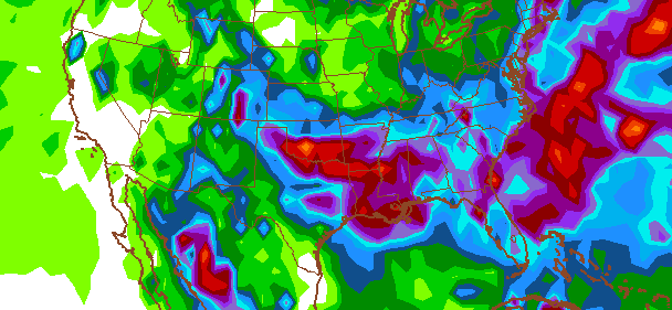
12z GFS still targets the Red River Valley as having the heaviest rainfall totals over the next 5 days:

Image
0 likes   

User avatar
dhweather
S2K Supporter
S2K Supporter
Posts: 6199
Joined: Sat Aug 14, 2004 9:29 pm
Location: Heath, TX
Contact:

#373 Postby dhweather » Tue Jul 15, 2014 2:48 pm

The 12Z Euro isn't much different, looking like Texarkana is the bullseye for heavy rain. I have a sickening feeling the metroplex will largely miss out on precip. Maybe 1" , but 80-100 miles to the north gets 4-5"
0 likes   
The above post and any post by dhweather is NOT an official forecast and should not be used as such. It is just the opinion of the poster and may or may not be backed by sound meteorological data. It is NOT endorsed by any professional institution including storm2k.org. For official information, please refer to NWS products.

User avatar
Janie2006
Category 5
Category 5
Posts: 1329
Joined: Mon Sep 18, 2006 3:28 pm
Location: coastal Ms aka home of the hurricanes

Re: Texas Summer - 2014

#374 Postby Janie2006 » Tue Jul 15, 2014 2:56 pm

Fascinating. Dewpoints in the low to mid 50s across a large swath of territory, from Denton (54*F) into middle Tennessee (~56*F) and beyond. North of that "boundary" they are even lower.....Branson and points north are recording dewpoints in the 40s.
0 likes   

User avatar
Ntxw
Storm2k Moderator
Storm2k Moderator
Posts: 22784
Joined: Wed Oct 21, 2009 6:34 pm
Location: DFW, Texas

Re:

#375 Postby Ntxw » Tue Jul 15, 2014 3:13 pm

dhweather wrote:The 12Z Euro isn't much different, looking like Texarkana is the bullseye for heavy rain. I have a sickening feeling the metroplex will largely miss out on precip. Maybe 1" , but 80-100 miles to the north gets 4-5"


I'm going to respectfully disagree. I think the models are not handling the movement of the shortwave as well as moisture content well. PWATS are highest south of the Red River and central/SE Texas. If this were winter, I would agree, hence some divergence of ENS where you follow lift over rich moisture. It is where the richest moisture meets the forcing that greatest precipitation rates will occur this time of year. While the Red River Valley will have the widest coverage they do not have the rich moisture content, some of the heftier total locales will be to the south in training storms, get lucky if you will.

Image

Regardless the water sheds will benefit greatly from the MCS coming from N to S/SE
0 likes   
The above post and any post by Ntxw is NOT an official forecast and should not be used as such. It is just the opinion of the poster and may or may not be backed by sound meteorological data. It is NOT endorsed by any professional institution including Storm2k. For official information, please refer to NWS products.


  Help support Storm2K!

Help Support Storm2K


User avatar
Ntxw
Storm2k Moderator
Storm2k Moderator
Posts: 22784
Joined: Wed Oct 21, 2009 6:34 pm
Location: DFW, Texas

Re: Texas Summer - 2014

#376 Postby Ntxw » Tue Jul 15, 2014 3:32 pm

NWS FW basically summed up what I just posted nicely in a compact paragraph

"QPF IN A CONVECTIVE ENVIRONMENT IS A TOUGH FORECAST...BUT WE ARE
STILL ADVERTISING THE POSSIBILITY OF OVER 3-4 INCHES IN NORTHEAST
COUNTIES TAPERING DOWN TO ABOUT AN INCH IN OUR SOUTHERN COUNTIES.
SHOULD THE TRACK OF THESE DISTURBANCES CHANGE NORTH OR SOUTH...QPF
WILL HAVE TO CHANGE WITH IT AS WELL. ACTUAL QPF ALWAYS APPEARS
MUCH MORE STREAKY AND VARIABLE THAN WHAT WE FORECAST."
0 likes   
The above post and any post by Ntxw is NOT an official forecast and should not be used as such. It is just the opinion of the poster and may or may not be backed by sound meteorological data. It is NOT endorsed by any professional institution including Storm2k. For official information, please refer to NWS products.


  Help support Storm2K!

Help Support Storm2K


User avatar
Tireman4
S2K Supporter
S2K Supporter
Posts: 5853
Age: 59
Joined: Fri Jun 30, 2006 1:08 pm
Location: Humble, Texas
Contact:

Re: Texas Summer - 2014

#377 Postby Tireman4 » Tue Jul 15, 2014 3:57 pm

somethingfunny wrote:IT IS SO NICE OUTSIDE!!!!!


And you gotta rub it in. Gee whiz sir.
0 likes   

User avatar
somethingfunny
ChatStaff
ChatStaff
Posts: 3926
Age: 37
Joined: Thu May 31, 2007 10:30 pm
Location: McKinney, Texas

Re: Texas Summer - 2014

#378 Postby somethingfunny » Tue Jul 15, 2014 4:14 pm

Tireman4 wrote:
somethingfunny wrote:IT IS SO NICE OUTSIDE!!!!!


And you gotta rub it in. Gee whiz sir.


Well, you got rain so....

:P
0 likes   
I am not a meteorologist, and any posts made by me are not official forecasts or to be interpreted as being intelligent. These posts are just my opinions and are probably silly opinions.

User avatar
TeamPlayersBlue
Category 5
Category 5
Posts: 3445
Joined: Tue Feb 02, 2010 1:44 am
Location: Denver/Applewood, CO

#379 Postby TeamPlayersBlue » Tue Jul 15, 2014 4:24 pm

Earlier today at around 1PM, i went running at Memorial and it was 84F with no rain. Some light showers in the area but not falling. I dont this has ever happened before. Cooler temps made me feel like a champ while i was running.


I have to give JB credit, looks like he is calling this modiki el nino spot on after even i thought he was nuts. He says this winter will be brutal as well. I agree. I think with the warm pool still there, or if it hangs around that this one will be almost as bad as last but with more precip. It sounds like a dream scenario but i dont see why not. With more moisture to overrun the cold temps at the surface why not.

This also brings something else to my mind, last year we had numerous shallow cold air events setting up mostly ice events. What has to happen in the atmosphere for the cold air to not be so deep. I know that dense cold air sinks but we had some major shots of cold air but they would still only bring us ice events.

Hoping the SE Tx crew can get a true winter event this year instead of the teasing we had last year :)
0 likes   
Personal Forecast Disclaimer:
The posts in this forum are NOT official forecast and should not be used as such. They are just the opinion of the poster and may or may not be backed by sound meteorological data. They are NOT endorsed by any professional institution or storm2k.org. For official information, please refer to the NHC and NWS products.

User avatar
srainhoutx
S2K Supporter
S2K Supporter
Posts: 6919
Age: 67
Joined: Sun Jan 14, 2007 11:34 am
Location: Haywood County, NC
Contact:

Re:

#380 Postby srainhoutx » Tue Jul 15, 2014 4:59 pm

TeamPlayersBlue wrote:
Hoping the SE Tx crew can get a true winter event this year instead of the teasing we had last year :)


I would call an inch of freezing rain with trees and power lines falling across the W /NW/N and NE Harris County in early last March a tease, but that's just me... :P
0 likes   
Carla/Alicia/Jerry(In The Eye)/Michelle/Charley/Ivan/Dennis/Katrina/Rita/Wilma/Ike/Harvey

Member: National Weather Association
Wx Infinity Forums
http://wxinfinity.com/index.php

Facebook.com/WeatherInfinity
Twitter @WeatherInfinity


Return to “USA & Caribbean Weather”

Who is online

Users browsing this forum: txtwister78 and 9 guests