Global model runs discussion

Moderator: S2k Moderators

Message
Author
User avatar
Yellow Evan
Professional-Met
Professional-Met
Posts: 16143
Age: 27
Joined: Fri Jul 15, 2011 12:48 pm
Location: Henderson, Nevada/Honolulu, HI
Contact:

Re:

#7001 Postby Yellow Evan » Mon Jul 14, 2014 6:56 pm

hurricanetrack wrote:It is mid-July, if there was not a lot of dry air in the MDR I would be quite worried and for a completely different reason :-)


It's more than normal though.
0 likes   

User avatar
SFLcane
S2K Supporter
S2K Supporter
Posts: 10163
Age: 47
Joined: Sat Jun 05, 2010 1:44 pm
Location: Lake Worth Florida

Re: Global Model Runs Discussion

#7002 Postby SFLcane » Mon Jul 14, 2014 7:12 pm

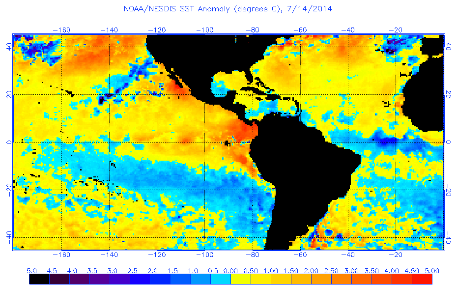
57 Yep which could pose problems once they make it into a more favorable environment near 60-70w. Also sst's across the MDR have somewhat recovered last few weeks. Should be ok come mid-aug when real season starts. Also sal tends to peak around this time so nothing strange there.

Image
0 likes   

User avatar
gatorcane
S2K Supporter
S2K Supporter
Posts: 23691
Age: 47
Joined: Sun Mar 13, 2005 3:54 pm
Location: Boca Raton, FL

#7003 Postby gatorcane » Tue Jul 15, 2014 9:35 pm

Well this large area of convection over Africa is likely associated with the wave that some of the global models thought might form an area of low pressure SW of the Cape Verde islands down the road. Models are not even showing a closed low forming out of this any longer, however, with the latest ECMWF solution showing a strong wave signature traversing what still appears to be a very hostile MDR.

Far East Atlantic IR saved image:
Image

12Z ECMWF 144 hours:
Image
0 likes   

User avatar
weatherwindow
Category 4
Category 4
Posts: 904
Joined: Mon Sep 20, 2004 9:48 am
Location: key west/ft lauderdale

Re: Global Model Runs Discussion

#7004 Postby weatherwindow » Wed Jul 16, 2014 12:10 pm

StormTracker wrote:Forgive me if this question has already been posted, but does anyone know if there have ever been two or more consecutive "extremely dud" (a.k.a.: last season) seasons in the recorded history of hurricane seasons???


Several series of consecutive multiple "duds"....1981, 82, 83, 84...93, 94...and many others since 1851...Many of these very quiet seasons are associated with the negative phase of the AMO(thermohaline circulation) and/or El Ninos...However, as evidenced by 2012/2013, they are not restricted to only those backround conditions....Grtz from KW, Rich

http://weather.unisys.com/hurricane/atlantic/
0 likes   

ninel conde

Re: Global Model Runs Discussion

#7005 Postby ninel conde » Wed Jul 16, 2014 3:25 pm

weatherwindow wrote:
StormTracker wrote:Forgive me if this question has already been posted, but does anyone know if there have ever been two or more consecutive "extremely dud" (a.k.a.: last season) seasons in the recorded history of hurricane seasons???


Several series of consecutive multiple "duds"....1981, 82, 83, 84...93, 94...and many others since 1851...Many of these very quiet seasons are associated with the negative phase of the AMO(thermohaline circulation) and/or El Ninos...However, as evidenced by 2012/2013, they are not restricted to only those backround conditions....Grtz from KW, Rich

http://weather.unisys.com/hurricane/atlantic/


i would add 1971-1978 as a long string of "duds"
0 likes   

User avatar
Hammy
Category 5
Category 5
Posts: 5849
Age: 42
Joined: Fri May 25, 2012 5:25 pm
Contact:

Re: Global Model Runs Discussion

#7006 Postby Hammy » Wed Jul 16, 2014 3:46 pm

I wouldn't exactly consider 1971, 1974, or 1975 duds, considering they were all fairly active and even had a few major storms landfalling, including Fifi in 1974 which killed nearly 10,000, or even 1981, which had a good number of strong hurricanes.
0 likes   
The above post is not official and should not be used as such. It is the opinion of the poster and may or may not be backed by sound meteorological data. It is not endorsed by any professional institution or storm2k.org. For official information, please refer to the NHC and NWS products.

tolakram
Admin
Admin
Posts: 20010
Age: 62
Joined: Sun Aug 27, 2006 8:23 pm
Location: Florence, KY (name is Mark)

#7007 Postby tolakram » Wed Jul 16, 2014 4:15 pm

Let's get back on topic please.
0 likes   
M a r k
- - - - -
Join us in chat: Storm2K Chatroom Invite. Android and IOS apps also available.

The posts in this forum are NOT official forecasts and should not be used as such. Posts are NOT endorsed by any professional institution or STORM2K.org. For official information and forecasts, please refer to NHC and NWS products.

User avatar
cycloneye
Admin
Admin
Posts: 145382
Age: 68
Joined: Thu Oct 10, 2002 10:54 am
Location: San Juan, Puerto Rico

Re: Global Model Runs Discussion

#7008 Postby cycloneye » Wed Jul 16, 2014 4:47 pm

Not forming into a TC but if what ECMWF pans out, a good rain event would arrive towards the islands for late next week that some of them need badly including PR.

Image
0 likes   
Visit the Caribbean-Central America Weather Thread where you can find at first post web cams,radars
and observations from Caribbean basin members Click Here

hurricanehunter69
Category 1
Category 1
Posts: 343
Joined: Sun May 16, 2010 5:21 pm
Location: New Orleans

Re: Global Model Runs Discussion

#7009 Postby hurricanehunter69 » Wed Jul 16, 2014 8:33 pm

GFS 18z showin a little somthin somthin.....? http://mag.ncep.noaa.gov/Image.php?fhr= ... =&ps=model
0 likes   

HurricaneFan
Tropical Storm
Tropical Storm
Posts: 192
Age: 41
Joined: Tue Jan 18, 2011 6:16 pm
Location: Anguilla,Leeward Islands 18.3N 63.0W

Re: Global Model Runs Discussion

#7010 Postby HurricaneFan » Wed Jul 16, 2014 8:46 pm

Is that pouch 4L just East of the Islands on the ECMWF 10 days from now?
That should hit the Islands in the 2 next days(on Monday,July 28th) on that graphic if it pans out?
0 likes   

User avatar
cycloneye
Admin
Admin
Posts: 145382
Age: 68
Joined: Thu Oct 10, 2002 10:54 am
Location: San Juan, Puerto Rico

Re: Global Model Runs Discussion

#7011 Postby cycloneye » Wed Jul 16, 2014 8:56 pm

HurricaneFan wrote:Is that pouch 4L just East of the Islands on the ECMWF 10 days from now?That should hit the Islands in the 2 next days(on Monday,July 28th) on that graphic if it pans out?


04L may be the one but is too early to know.Let a few days pass and we will have a better idea if the models start to pick it. We need a soaker here to aliviate or end the drought. :)
0 likes   
Visit the Caribbean-Central America Weather Thread where you can find at first post web cams,radars
and observations from Caribbean basin members Click Here

User avatar
blp
Category 5
Category 5
Posts: 2840
Age: 46
Joined: Thu Sep 09, 2004 7:51 pm
Location: Miami, FL
Contact:

Re: Global Model Runs Discussion

#7012 Postby blp » Thu Jul 17, 2014 3:13 pm

Not saying it will happen but the CFS continues to advertise some action for August. Looks like conditions may become conducive for a few storms to develop out of the MDR.

http://www.weatheronline.co.uk/cgi-bin/expertcharts?LANG=en&MENU=0000000000&CONT=noat&MODELL=cfs&MODELLTYP=1&BASE=-&VAR=pslv&HH=396&ZOOM=0&ARCHIV=0&LOOP=1&RES=0
0 likes   
The following post is NOT an official forecast and should not be used as such. It is just the opinion of the poster and may or may not be backed by sound meteorological data. It is NOT endorsed by any professional institution including storm2k.org For Official Information please refer to the NHC and NWS products.

User avatar
PTrackerLA
Category 5
Category 5
Posts: 5277
Age: 41
Joined: Thu Oct 10, 2002 8:40 pm
Location: Lafayette, LA

Re: Global Model Runs Discussion

#7013 Postby PTrackerLA » Thu Jul 17, 2014 3:32 pm

That CFS run is interesting. Is it ever remotely correct 30 days out?
0 likes   

User avatar
Hurricaneman
Category 5
Category 5
Posts: 7351
Age: 45
Joined: Tue Aug 31, 2004 3:24 pm
Location: central florida

Re: Global Model Runs Discussion

#7014 Postby Hurricaneman » Thu Jul 17, 2014 7:00 pm

PTrackerLA wrote:That CFS run is interesting. Is it ever remotely correct 30 days out?


shows something crossing florida around Melbourne on the 17th of August which is really dubious in that range at best but one thing to take from it though is that the MDR is forecast from the CFS to become a lot more favorable as we come to the peak of hurricane season and definitely tons more favorable than last year so IMO around the late part of the month or Early August need to be watched if the CFS is even remotely close

The posts in this forum are NOT official forecast and should not be used as such. They are just the opinion of the poster and may or may not be backed by sound meteorological data. They are NOT endorsed by any professional institution or storm2k.org. For official information, please refer to the NHC and NWS products
0 likes   

TheStormExpert

Re: Global Model Runs Discussion

#7015 Postby TheStormExpert » Thu Jul 17, 2014 7:20 pm

Hurricaneman wrote:
PTrackerLA wrote:That CFS run is interesting. Is it ever remotely correct 30 days out?


shows something crossing florida around Melbourne on the 17th of August which is really dubious in that range at best but one thing to take from it though is that the MDR is forecast from the CFS to become a lot more favorable as we come to the peak of hurricane season and definitely tons more favorable than last year so IMO around the late part of the month or Early August need to be watched if the CFS is even remotely close

The posts in this forum are NOT official forecast and should not be used as such. They are just the opinion of the poster and may or may not be backed by sound meteorological data. They are NOT endorsed by any professional institution or storm2k.org. For official information, please refer to the NHC and NWS products

My question is did the CFS show it being active like this last year, and how reliable is the CFS this far out to start getting ideas?
0 likes   

User avatar
Hurricaneman
Category 5
Category 5
Posts: 7351
Age: 45
Joined: Tue Aug 31, 2004 3:24 pm
Location: central florida

Re: Global Model Runs Discussion

#7016 Postby Hurricaneman » Thu Jul 17, 2014 7:28 pm

TheStormExpert wrote:
Hurricaneman wrote:
PTrackerLA wrote:That CFS run is interesting. Is it ever remotely correct 30 days out?


shows something crossing florida around Melbourne on the 17th of August which is really dubious in that range at best but one thing to take from it though is that the MDR is forecast from the CFS to become a lot more favorable as we come to the peak of hurricane season and definitely tons more favorable than last year so IMO around the late part of the month or Early August need to be watched if the CFS is even remotely close

The posts in this forum are NOT official forecast and should not be used as such. They are just the opinion of the poster and may or may not be backed by sound meteorological data. They are NOT endorsed by any professional institution or storm2k.org. For official information, please refer to the NHC and NWS products

My question is did the CFS show it being active like this last year, and how reliable is the CFS this far out to start getting ideas?


It was pretty much quiet last year but it pretty much is quite off on tracks and stuff like that but does show a possible pattern of better favorability around early to mid August

The posts in this forum are NOT official forecast and should not be used as such. They are just the opinion of the poster and may or may not be backed by sound meteorological data. They are NOT endorsed by any professional institution or storm2k.org. For official information, please refer to the NHC and NWS products
0 likes   

User avatar
blp
Category 5
Category 5
Posts: 2840
Age: 46
Joined: Thu Sep 09, 2004 7:51 pm
Location: Miami, FL
Contact:

Re: Global Model Runs Discussion

#7017 Postby blp » Thu Jul 17, 2014 7:49 pm

TheStormExpert wrote:My question is did the CFS show it being active like this last year, and how reliable is the CFS this far out to start getting ideas?


Last year it did not have nowhere near the level of activity you are seeing now, so it did good with predicting the slow season. I have looked at the CFS often the past several years and in IMO it does help with picking out patterns. For instance, it was helpful in showing the pattern of troughs in the MDR during 2012. So you need to take CFS as a possible predictor of pattern and activity levels but not for a specific area of development.
0 likes   
The following post is NOT an official forecast and should not be used as such. It is just the opinion of the poster and may or may not be backed by sound meteorological data. It is NOT endorsed by any professional institution including storm2k.org For Official Information please refer to the NHC and NWS products.

User avatar
Yellow Evan
Professional-Met
Professional-Met
Posts: 16143
Age: 27
Joined: Fri Jul 15, 2011 12:48 pm
Location: Henderson, Nevada/Honolulu, HI
Contact:

Re: Global Model Runs Discussion

#7018 Postby Yellow Evan » Thu Jul 17, 2014 8:50 pm

blp wrote:
TheStormExpert wrote:My question is did the CFS show it being active like this last year, and how reliable is the CFS this far out to start getting ideas?


Last year it did not have nowhere near the level of activity you are seeing now, so it did good with predicting the slow season. I have looked at the CFS often the past several years and in IMO it does help with picking out patterns. For instance, it was helpful in showing the pattern of troughs in the MDR during 2012. So you need to take CFS as a possible predictor of pattern and activity levels but not for a specific area of development.


How did it do in 2009?

I think it's good in the EPAC for such long range.
0 likes   

TheStormExpert

Re: Global Model Runs Discussion

#7019 Postby TheStormExpert » Thu Jul 17, 2014 10:10 pm

blp wrote:
TheStormExpert wrote:My question is did the CFS show it being active like this last year, and how reliable is the CFS this far out to start getting ideas?


Last year it did not have nowhere near the level of activity you are seeing now, so it did good with predicting the slow season. I have looked at the CFS often the past several years and in IMO it does help with picking out patterns. For instance, it was helpful in showing the pattern of troughs in the MDR during 2012. So you need to take CFS as a possible predictor of pattern and activity levels but not for a specific area of development.

What is the pattern like now?
0 likes   

User avatar
blp
Category 5
Category 5
Posts: 2840
Age: 46
Joined: Thu Sep 09, 2004 7:51 pm
Location: Miami, FL
Contact:

Re: Global Model Runs Discussion

#7020 Postby blp » Thu Jul 17, 2014 10:28 pm

Yellow Evan wrote:
How did it do in 2009?

I think it's good in the EPAC for such long range.


Don't know, I did not look at it back then.
0 likes   
The following post is NOT an official forecast and should not be used as such. It is just the opinion of the poster and may or may not be backed by sound meteorological data. It is NOT endorsed by any professional institution including storm2k.org For Official Information please refer to the NHC and NWS products.


Return to “2015”

Who is online

Users browsing this forum: No registered users and 6 guests