Tropical Wave East of Lesser Antilles (Is Invest 92L)
Moderator: S2k Moderators
Forum rules
The posts in this forum are NOT official forecasts and should not be used as such. They are just the opinion of the poster and may or may not be backed by sound meteorological data. They are NOT endorsed by any professional institution or STORM2K. For official information, please refer to products from the National Hurricane Center and National Weather Service.
- wxman57
- Moderator-Pro Met

- Posts: 23118
- Age: 68
- Joined: Sat Jun 21, 2003 8:06 pm
- Location: Houston, TX (southwest)
Re: Tropical Wave in East Atlantic (Pouch 03L)
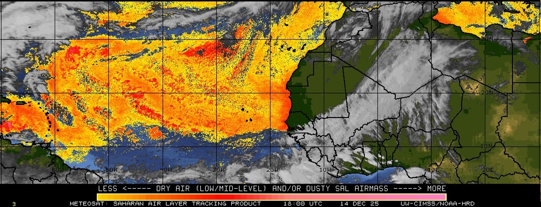
The environment in its path is quite hostile all the way to the western Caribbean. It's dominated by considerable dry air in the mid levels due to widespread subsidence.
0 likes
- SFLcane
- S2K Supporter

- Posts: 10281
- Age: 48
- Joined: Sat Jun 05, 2010 1:44 pm
- Location: Lake Worth Florida
Re: Tropical Wave in East Atlantic (Pouch 03L)
Would have to stay south if it wants chance to develop stable air just to its north. Not expecting much to develope


Last edited by SFLcane on Sat Jul 19, 2014 9:42 am, edited 1 time in total.
0 likes
-
TheStormExpert
Re: Tropical Wave in East Atlantic (Pouch 03L)
0 likes
The following post is NOT an official forecast and should not be used as such. It is just the opinion of the poster and may or may not be backed by sound meteorological data. It is NOT endorsed by any professional institution including storm2k.org For Official Information please refer to the NHC and NWS products.
Re: Tropical Wave in East Atlantic (Pouch 03L)
wxman57 wrote:The environment in its path is quite hostile all the way to the western Caribbean. It's dominated by considerable dry air in the mid levels due to widespread subsidence.
Wxman57, the GFS and CMC have it staying north of the Carribean and most of dry air. I am with you if it takes a route into the Carribean it is toast.
0 likes
The following post is NOT an official forecast and should not be used as such. It is just the opinion of the poster and may or may not be backed by sound meteorological data. It is NOT endorsed by any professional institution including storm2k.org For Official Information please refer to the NHC and NWS products.
-
TheStormExpert
- cycloneye
- Admin

- Posts: 148719
- Age: 69
- Joined: Thu Oct 10, 2002 10:54 am
- Location: San Juan, Puerto Rico
Re: Tropical Wave in East Atlantic (Pouch 03L)
TAFB at the 12z surface analysis adds a low. Maybe NHC starts to mention it later today at the TWO's


0 likes
Visit the Caribbean-Central America Weather Thread where you can find at first post web cams,radars
and observations from Caribbean basin members Click Here
and observations from Caribbean basin members Click Here
- gatorcane
- S2K Supporter

- Posts: 23703
- Age: 47
- Joined: Sun Mar 13, 2005 3:54 pm
- Location: Boca Raton, FL
Re:
TheStormExpert wrote::uarrow: If this were to develop it looks as if a strong trough would be waiting off the E. Coast to turn it out to sea being only a potential threat to Bermuda, MAYBE Canada. Seems like the pattern may be switching to one very similar to the one present during the 2010/2011 seasons?
It does look like there will be a another large trough over the Western Atlantic next weekend as advertised by all the global models but chances are this system probably won't develop beyond a weak low anyway because of the unfavorable environment further west.
0 likes
-
TheStormExpert
-
HurricaneTracker2031
- Tropical Storm

- Posts: 248
- Age: 26
- Joined: Fri Jul 19, 2013 7:20 pm
- Location: Pembroke Pines, FL, USA
- Contact:
Re: Tropical Wave in East Atlantic (Pouch 03L)
Pouch 03L looks good today and is beginning to rotate. It only has until Monday/Tuesday before it is affected by SAL. We will see..

Synopsis for Atlantic and other basins: http://goo.gl/FxWsKm
Personal Forecast Disclaimer
The posts in this forum are NOT official forecast and should not be used as such. They are just the opinion of the poster and may or may not be backed by sound meteorological data. They are NOT endorsed by any professional institution or storm2k.org. For official information, please refer to the NHC and NWS products.
0 likes
SHORT VERSION OF DISCLAIMER: THIS SITE LINK BELOW IS NOT AN OFFICIAL FORECASTING OFFICE AND SHOULD NOT BE USED TO MAKE ANY EMERGENCY DECISIONS....
http://www.macstropicalweather.weebly.com
http://www.macstropicalweather.weebly.com
Re:
gatorcane wrote:12Z ECMWF shows this low fizzling out by 48 hours. Conditions appear too hostile plus it is early to be expecting development out that far anyway. These waves should start have more of a chance in the MDR about 3-4 weeks from now.
I agree it is early. There may be an invest in the next day or two and then it will get crushed by the dry air that is already present past 40W.
This is a good indicator IMO though that the MDR activity may be closer to Normal this year.
0 likes
The following post is NOT an official forecast and should not be used as such. It is just the opinion of the poster and may or may not be backed by sound meteorological data. It is NOT endorsed by any professional institution including storm2k.org For Official Information please refer to the NHC and NWS products.
- northjaxpro
- S2K Supporter

- Posts: 8900
- Joined: Mon Sep 27, 2010 11:21 am
- Location: Jacksonville, FL
Re:
gatorcane wrote:12Z ECMWF shows this low fizzling out by 48 hours. Conditions appear too hostile plus it is early to be expecting development out that far anyway. These waves should start have more of a chance in the MDR about 3-4 weeks from now.
Totally agree. Conditions are simply too hostile out there in the MDR and I won't start paying attention out there until about a month from now.
0 likes
NEVER, EVER SAY NEVER in the tropics and weather in general, and most importantly, with life itself!!
________________________________________________________________________________________
Fay 2008 Beryl 2012 Debby 2012 Colin 2016 Hermine 2016 Julia 2016 Matthew 2016 Irma 2017 Dorian 2019
________________________________________________________________________________________
Fay 2008 Beryl 2012 Debby 2012 Colin 2016 Hermine 2016 Julia 2016 Matthew 2016 Irma 2017 Dorian 2019
- cycloneye
- Admin

- Posts: 148719
- Age: 69
- Joined: Thu Oct 10, 2002 10:54 am
- Location: San Juan, Puerto Rico
Re: Tropical Wave in East Atlantic (Pouch 03L)
8 PM.
A TROPICAL WAVE EXTENDING FROM 16N33W THROUGH A 1014 MB LOW NEAR
09N35W TO 07N35W IS MOVING W AT 15 KT. RECENT SATELLITE IMAGERY
SUGGESTS ADDITIONAL CYCLONIC TURNING TO THE NE OF THE CURRENT
SURFACE LOW WHICH MAY NECESSITATE REPOSITIONING OF THE LOW AND
THE WAVE SYSTEM AT 00 UTC. SCATTERED MODERATE ISOLATED STRONG
CONVECTION WAS INDICATED FROM 7N-11N BETWEEN 30W-35W.
0 likes
Visit the Caribbean-Central America Weather Thread where you can find at first post web cams,radars
and observations from Caribbean basin members Click Here
and observations from Caribbean basin members Click Here
-
Dean4Storms
- S2K Supporter

- Posts: 6358
- Age: 62
- Joined: Sun Aug 31, 2003 1:01 pm
- Location: Miramar Bch. FL
- Blown Away
- S2K Supporter

- Posts: 10253
- Joined: Wed May 26, 2004 6:17 am
Re: Tropical Wave in East Atlantic (Pouch 03L)

TAFB has our TW with a low in 72 hours...
0 likes
Hurricane Eye Experience: David 79, Irene 99, Frances 04, Jeanne 04, Wilma 05… Hurricane Brush Experience: Andrew 92, Erin 95, Floyd 99, Matthew 16, Irma 17, Ian 22, Nicole 22…
- cycloneye
- Admin

- Posts: 148719
- Age: 69
- Joined: Thu Oct 10, 2002 10:54 am
- Location: San Juan, Puerto Rico
Re: Tropical Wave in East Atlantic (Pouch 03L)
The future for pouch 03L doesn't look too bright as you can see as dry air is dominating the MDR.The wave has some precipitation rate high but not a lot to protect it from the dry air.


0 likes
Visit the Caribbean-Central America Weather Thread where you can find at first post web cams,radars
and observations from Caribbean basin members Click Here
and observations from Caribbean basin members Click Here
- cycloneye
- Admin

- Posts: 148719
- Age: 69
- Joined: Thu Oct 10, 2002 10:54 am
- Location: San Juan, Puerto Rico
Re: Tropical Wave in East Atlantic (Pouch 03L)
TROPICAL WEATHER OUTLOOK
NWS NATIONAL HURRICANE CENTER MIAMI FL
200 PM EDT SUN JUL 20 2014
For the North Atlantic...Caribbean Sea and the Gulf of Mexico:
A broad area of low pressure, associated with a tropical wave, is
located over the eastern Atlantic Ocean about midway between the
west coast of Africa and the Leeward Islands. Showers and
thunderstorms are currently disorganized, and any development during
the next day or two should be slow to occur. Beyond a couple of
days, environmental conditions are expected to become unfavorable
for development while the system moves westward at 15 to 20 mph.
* Formation chance through 48 hours...low...10 percent.
* Formation chance through 5 days...low...10 percent.
$$
Forecaster Cangialosi/Brennan
0 likes
Visit the Caribbean-Central America Weather Thread where you can find at first post web cams,radars
and observations from Caribbean basin members Click Here
and observations from Caribbean basin members Click Here
-
TheStormExpert
-
floridasun78
- Category 5

- Posts: 3755
- Joined: Sun May 17, 2009 10:16 pm
- Location: miami fl
Who is online
Users browsing this forum: No registered users and 71 guests


