Eastward propagation of the weak MJO and Kelvin Waves may warm the equatorial Pacific for sure to get El Nino declared officially in the next 2-3 months.Here is the CPC Global Hazard discussion.
http://www.cpc.ncep.noaa.gov/products/p ... /ghazards/
ENSO Updates (2007 thru 2023)
Moderator: S2k Moderators
Forum rules

The posts in this forum are NOT official forecasts and should not be used as such. They are just the opinion of the poster and may or may not be backed by sound meteorological data. They are NOT endorsed by any professional institution or STORM2K. For official information, please refer to products from the National Hurricane Center and National Weather Service.
-
cycloneye

- Admin

- Posts: 149447
- Age: 69
- Joined: Thu Oct 10, 2002 10:54 am
- Location: San Juan, Puerto Rico
Re: ENSO: BoM 7/15/14 update=El Nino remains on hold
0 likes
Visit the Caribbean-Central America Weather Thread where you can find at first post web cams,radars
and observations from Caribbean basin members Click Here
and observations from Caribbean basin members Click Here

Re: ENSO: BoM 7/15/14 update=El Nino remains on hold
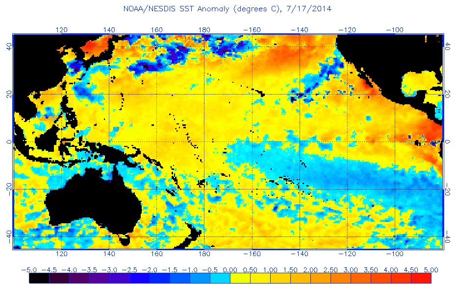
Checking the sub-surface water temps, the cooler pool seems to be gradually shrinking and there may be a new warm pool forming to the west.
0 likes
The above post is not official and should not be used as such. It is the opinion of the poster and may or may not be backed by sound meteorological data. It is not endorsed by any professional institution or storm2k.org. For official information, please refer to the NHC and NWS products.

Re: ENSO Updates
LarryWx wrote:LarryWx wrote:It still looks like -SOI's will dominate through the end of the month (although it should at least approach zero 6/29-30 before quickly dropping back). We should get some -20's into the mix, possibly including the next two days and ~7/1. The negatives should dominate through 7/3. However, it still looks like there will be a decided rise to positives and it looks to make it at least to the +10's 7/5-6 with a potential peak in the +20's or so around 7/9. It still looks like 7/1-10 will average positive despite the ~-20's on 7/1. Yesterday, I had projected near +1 for the final June monthly SOI. However, I'm now going with near 0 for June as a whole. Regardless, the bottom line is that there still is no longlasting solidly negative SOI on the horizon per the Euro at least. Instead, there looks to be a pretty even mix between negatives and positive between now and 7/10.
Verification of 6/25 Euro, which I used for the predictions stated above: the pattern was hit pretty well, but 6/26-7/3 were even more negative than progged overall. June as a whole ended at ~-1 instead of 0.
Looking ahead as per the 0Z 7/3/ Euro: Rising to -5 to +5 range 7/4 followed by rise to the ~+teens 7/6-7. After that, it should fall through 7/13, when it could bottom in the -30's. I had though that 7/1-10 would average positive. However, it now looks like it will average ~-2 to -3. As of 7/13, it appears now that both the MTD and the 30 day will be in the general vicinity of -6 to -8. The Euro ensemble suggests that the SOI will mainly rise 7/14-18. However, it is hard to tell if it would rise out of the negatives during that period on any of those days. So, it looks like 7/1-18 will easily average negative..perhaps still down at ~-5.
So, bottom line from my perspective per the Euro has changed: despite the prog of positives 7/5-8, it looks like we are and we'll continue to be into a period of negatives dominating to some extent as opposed to the prior back and forth we had through 6/21. Based on the Euro, it now looks to me that July has a very good shot at being the most -SOI month since March, 2014. Will July (as well as what we just had in late June) be enough to finally resume the trek toward El Nino? We'll see. Being that OHC has risen so much recently (to near neutral), that remains to be seen.
Looking at the above 0Z 7/3 Euro predictions, it did well, especially considering the volatility. It still looks like 7/1-18 will be near -5.
Looking ahead per the 0Z 7/15 Euro:
7/16: +5 to +15
7/17: -5 to +5
7/18-21:rising to mainly in the +3 to +13 range with small peak 7/19-20.
7/22-4: falling slowly to mainly in the -8 to +2 range with lowest 7/23
7/25: rising to the -1 to +9 range
In summary, much less volatility than recently and averaging slightly positive over the next ten days. 7/1-25 should be near -2 and the 30 day then should be near -4.
0 likes
Personal Forecast Disclaimer:
The posts in this forum are NOT official forecasts and should not be used as such. They are just the opinion of the poster and may or may not be backed by sound meteorological data. They are NOT endorsed by any professional institution or storm2k.org. For official information, please refer to the NHC and NWS products.
The posts in this forum are NOT official forecasts and should not be used as such. They are just the opinion of the poster and may or may not be backed by sound meteorological data. They are NOT endorsed by any professional institution or storm2k.org. For official information, please refer to the NHC and NWS products.
-
hurricanetrack

- HurricaneTrack.com

- Posts: 1781
- Joined: Tue Dec 02, 2003 10:46 pm
- Location: Wilmington, NC
- Contact:
http://www.cpc.ncep.noaa.gov/products/a ... eq_anm.gif
I believe firmly that the chance of ANY El Nino getting declared this year is dropping. No significant warm water pool coming in from west - certainly nothing any where near what came across this past spring. Cool anomalies in the eastern third and now 1-2 beginning to modify cooler. Man oh man, this sure seems like a bust in the climate models to me. We'll see but right now it sure looks like El Nino is losing.
I believe firmly that the chance of ANY El Nino getting declared this year is dropping. No significant warm water pool coming in from west - certainly nothing any where near what came across this past spring. Cool anomalies in the eastern third and now 1-2 beginning to modify cooler. Man oh man, this sure seems like a bust in the climate models to me. We'll see but right now it sure looks like El Nino is losing.
0 likes
-
'CaneFreak

- Category 5
- Posts: 1487
- Joined: Mon Jun 05, 2006 10:50 am
- Location: New Bern, NC
Re: ENSO: BoM 7/15/14 update=El Nino remains on hold
Nah. It is just now re-establishing itself. Notice the warm anomalies re-appearing in the West Pacific? That will work east over time. We just went through an upwelling phase of the Kelvin Wave that is now beginning to wane. See page 15 of the latest CPC ENSO discussion. This same type of thing has been observed in El Ninos of the recent past - it doesn't always go straight to an El Nino. Sometimes it comes in stages. At least a moderate El Nino is still very likely IMO.
http://www.cpc.ncep.noaa.gov/products/analysis_monitoring/lanina/enso_evolution-status-fcsts-web.pdf
http://www.cpc.ncep.noaa.gov/products/analysis_monitoring/lanina/enso_evolution-status-fcsts-web.pdf
hurricanetrack wrote:http://www.cpc.ncep.noaa.gov/products/analysis_monitoring/ocean/anim/wkxzteq_anm.gif
I believe firmly that the chance of ANY El Nino getting declared this year is dropping. No significant warm water pool coming in from west - certainly nothing any where near what came across this past spring. Cool anomalies in the eastern third and now 1-2 beginning to modify cooler. Man oh man, this sure seems like a bust in the climate models to me. We'll see but right now it sure looks like El Nino is losing.
0 likes
-
cycloneye
- Admin
- Posts: 149447
- Age: 69
- Joined: Thu Oct 10, 2002 10:54 am
- Location: San Juan, Puerto Rico
Re: ENSO Updates
The latest update of the sub-surface shows how the once large warm pool has shrinked a lot. What we have to watch is for that growing warm pool in the WestCentral Pacific to see if it moves eastward.Saved loop.

0 likes
Visit the Caribbean-Central America Weather Thread where you can find at first post web cams,radars
and observations from Caribbean basin members Click Here
and observations from Caribbean basin members Click Here

Re: ENSO Updates
Euro's July updated ENSO Forecast, shows the current cooling at Nino 3.4, still persistent on an El Nino by Fall, moderate, going by the ensemble's average but since it is usually warm bias with forecasting the ENSO I wouldn't doubt if we only get a high end weak El Nino at the most.

Back in April's forecast not even one ensemble member got it right with the current cooling.

Back in April's forecast not even one ensemble member got it right with the current cooling.
0 likes
-
cycloneye
- Admin
- Posts: 149447
- Age: 69
- Joined: Thu Oct 10, 2002 10:54 am
- Location: San Juan, Puerto Rico
Re: ENSO Updates
The Mid-July update of the plume of models have the majority of them at Weak El Nino but some are at Moderate El Nino with peak at the NDJ period.The % of El Nino has decreased slightly compared to past months.For ASO is at 60% at it peaks at 75% for NDJ.


http://iri.columbia.edu/our-expertise/c ... -quicklook
http://iri.columbia.edu/our-expertise/c ... -quicklook
0 likes
Visit the Caribbean-Central America Weather Thread where you can find at first post web cams,radars
and observations from Caribbean basin members Click Here
and observations from Caribbean basin members Click Here
-
cycloneye
- Admin
- Posts: 149447
- Age: 69
- Joined: Thu Oct 10, 2002 10:54 am
- Location: San Juan, Puerto Rico
Re: ENSO Updates: June PDO down to +0.82
The PDO cooled a little bit as it was +1.80 in May and the June data is down to +0.82.
http://jisao.washington.edu/pdo/PDO.latest
http://jisao.washington.edu/pdo/PDO.latest
0 likes
Visit the Caribbean-Central America Weather Thread where you can find at first post web cams,radars
and observations from Caribbean basin members Click Here
and observations from Caribbean basin members Click Here
-
cycloneye
- Admin
- Posts: 149447
- Age: 69
- Joined: Thu Oct 10, 2002 10:54 am
- Location: San Juan, Puerto Rico
Re: ENSO Updates: June PDO down to +0.82
Ntxw,as the ESPN program PTI say,is something or nothing the small cooling of PDO?
0 likes
Visit the Caribbean-Central America Weather Thread where you can find at first post web cams,radars
and observations from Caribbean basin members Click Here
and observations from Caribbean basin members Click Here


Re: ENSO Updates: June PDO down to +0.82
cycloneye wrote:Ntxw,as the ESPN program PTI say,is something or nothing the small cooling of PDO?
It's quite a drop, but it's still fairly high considering what is needed for cool PDO. SST configuration hasn't changed much, July actually looks like it's reverting back to warming of the PDO but not much yet. Overall it's just extending the warm PDO streak that has now gone on for 6 months straight.
0 likes
The above post and any post by Ntxw is NOT an official forecast and should not be used as such. It is just the opinion of the poster and may or may not be backed by sound meteorological data. It is NOT endorsed by any professional institution including Storm2k. For official information, please refer to NWS products.
Help support Storm2K!

-
cycloneye
- Admin
- Posts: 149447
- Age: 69
- Joined: Thu Oct 10, 2002 10:54 am
- Location: San Juan, Puerto Rico
Re: ENSO Updates: June PDO down to +0.82
Here is a blog made by Michael Ventrice where he says El Nino will come by Fall.
The evolution of this year’s El Nino event is currently behaving as expected. There are waves in the Pacific Ocean currently “masking” the El Nino base state. But don’t be fooled: We expect a future warming of the El Nino 3.4 index later this fall in response to another eastward advection of warm waters from the West Pacific to the East Pacific.
Source
0 likes
Visit the Caribbean-Central America Weather Thread where you can find at first post web cams,radars
and observations from Caribbean basin members Click Here
and observations from Caribbean basin members Click Here

-
Yellow Evan

- Professional-Met

- Posts: 16240
- Age: 27
- Joined: Fri Jul 15, 2011 12:48 pm
- Location: Henderson, Nevada/Honolulu, HI
- Contact:
-
Yellow Evan
- Professional-Met
- Posts: 16240
- Age: 27
- Joined: Fri Jul 15, 2011 12:48 pm
- Location: Henderson, Nevada/Honolulu, HI
- Contact:
Re: ENSO Updates
OURAGAN wrote:Look at the source of Michael Ventrice, the européen forecast
Models have been showing some cooling of Ninos 1+2 for quite some times. Has it verified? Not really.
FTR, the ECMWF forecast isn't really a Modoki.
I'm not saying it is impossible for a Modoki to happen, but why are you 100% certain that this will be a Modoki.
0 likes
-
Yellow Evan
- Professional-Met
- Posts: 16240
- Age: 27
- Joined: Fri Jul 15, 2011 12:48 pm
- Location: Henderson, Nevada/Honolulu, HI
- Contact:
Re: ENSO Updates
OURAGAN wrote:But E.U. model says modiki and JB said that Few months ago
So what?
Don't wanna get into politics, but JB is politically driven. That's all I wanna say.
0 likes
Who is online
Users browsing this forum: No registered users and 140 guests