
The models are showing more recurving WPAC typhoons after Matmo. I would not bet against this, and the long range guidance has been flipping from warm to cool. We're going to start August with unusual below normal temperatures once past this week's heat wave at peak heat climo. This is not normal.
Any one of these 2-3SD's troughs and cool air masses would be memorable for any summer, but to have several is strange. This summer continued where winter of 2013-2014 left off.
Texas Summer - 2014
Moderator: S2k Moderators
Forum rules

The posts in this forum are NOT official forecast and should not be used as such. They are just the opinion of the poster and may or may not be backed by sound meteorological data. They are NOT endorsed by any professional institution or STORM2K.
Re: Texas Summer - 2014
0 likes
The above post and any post by Ntxw is NOT an official forecast and should not be used as such. It is just the opinion of the poster and may or may not be backed by sound meteorological data. It is NOT endorsed by any professional institution including Storm2k. For official information, please refer to NWS products.
Help support Storm2K!

Re: Texas Summer - 2014
Ntxw wrote:The models are showing more recurving WPAC typhoons after Matmo. I would not bet against this, and the long range guidance has been flipping from warm to cool. We're going to start August with unusual below normal temperatures once past this week's heat wave at peak heat climo. This is not normal.
Any one of these 2-3SD's troughs and cool air masses would be memorable for any summer, but to have several is strange. This summer continued where winter of 2013-2014 left off.
I am sure there have been summers like that in the past.
0 likes
Re: Texas Summer - 2014
Ptarmigan wrote:Ntxw wrote:The models are showing more recurving WPAC typhoons after Matmo. I would not bet against this, and the long range guidance has been flipping from warm to cool. We're going to start August with unusual below normal temperatures once past this week's heat wave at peak heat climo. This is not normal.
Any one of these 2-3SD's troughs and cool air masses would be memorable for any summer, but to have several is strange. This summer continued where winter of 2013-2014 left off.
I am sure there have been summers like that in the past.
There are several in mind particularly in the early 1900s. I'm familiar with wetter summers being cool, usually with upper level lows parked overhead in the long haul. That hasn't been so much the case but rather cooler air over NA and deepening troughs across the midwest/lakes. I'll have to dig deeper into EPO related summers.
0 likes
The above post and any post by Ntxw is NOT an official forecast and should not be used as such. It is just the opinion of the poster and may or may not be backed by sound meteorological data. It is NOT endorsed by any professional institution including Storm2k. For official information, please refer to NWS products.
Help support Storm2K!
Help support Storm2K!
Re: Texas Summer - 2014
Ntxw wrote:
There are several in mind particularly in the early 1900s. I'm familiar with wetter summers being cool, usually with upper level lows parked overhead in the long haul. That hasn't been so much the case but rather cooler air over NA and deepening troughs across the midwest/lakes. I'll have to dig deeper into EPO related summers.
I know there have been cool summers like in 1972, 1976, 1989, 1990, and 1992.
0 likes
-
weatherdude1108
- Category 5

- Posts: 4228
- Joined: Tue Dec 13, 2011 1:04 pm
- Location: Northwest Austin/Cedar Park, TX
I "woke up" from my Summer stupor when I read this blurb today from Bob Rose:
Long-range solutions indicate the pattern may turn interesting late next week as a piece of the upper trough breaks off and backs southwest across Texas. Should this solution be correct, the approaching upper trough would cause the development of rain showers and thunderstorms across much of Central and South Texas.
http://www.lcra.org/water/river-and-wea ... ather.aspx
0 likes
The preceding post is NOT an official forecast, and should not be used as such. It is only the opinion of the poster and may or may not be backed by sound meteorological data. It is NOT endorsed by any professional institution including storm2k.org. For Official Information please refer to the NHC and NWS products.
Re: Texas Summer - 2014
GFS decides to join the party. JB posted this of the model which falls in line with it's ENS. Euro is equally impressive with a shortwave coming down on the backside which brings rain to Texas similar to last week. It may be a 5-7 day forecast but I think it's pretty clear something is going to happen. Just a matter of fine tuning the details. May just be a repeat of what already was, definitely a day or two of 70s/80s in the cards which as mentioned before during peak climo will likely set records.

0 likes
The above post and any post by Ntxw is NOT an official forecast and should not be used as such. It is just the opinion of the poster and may or may not be backed by sound meteorological data. It is NOT endorsed by any professional institution including Storm2k. For official information, please refer to NWS products.
Help support Storm2K!
Help support Storm2K!
-
TeamPlayersBlue

- Category 5
- Posts: 3530
- Joined: Tue Feb 02, 2010 1:44 am
- Location: Denver/Applewood, CO
Do Typhoons typically not start recurving until later in the season?
0 likes
Personal Forecast Disclaimer:
The posts in this forum are NOT official forecast and should not be used as such. They are just the opinion of the poster and may or may not be backed by sound meteorological data. They are NOT endorsed by any professional institution or storm2k.org. For official information, please refer to the NHC and NWS products.
The posts in this forum are NOT official forecast and should not be used as such. They are just the opinion of the poster and may or may not be backed by sound meteorological data. They are NOT endorsed by any professional institution or storm2k.org. For official information, please refer to the NHC and NWS products.
Re:
TeamPlayersBlue wrote:Do Typhoons typically not start recurving until later in the season?
I believe they occur most during the fall when troughs starts dipping further south to pick them up. What is unusual is the amplification of troughs and ridges these typhoons have been signaling. Jet stream is normally further north in the heart of summer.
0 likes
The above post and any post by Ntxw is NOT an official forecast and should not be used as such. It is just the opinion of the poster and may or may not be backed by sound meteorological data. It is NOT endorsed by any professional institution including Storm2k. For official information, please refer to NWS products.
Help support Storm2K!
Help support Storm2K!

-
weatherdude1108
- Category 5
- Posts: 4228
- Joined: Tue Dec 13, 2011 1:04 pm
- Location: Northwest Austin/Cedar Park, TX
I am CAUTIOUSLY optimistic.
AREA FORECAST DISCUSSION
NATIONAL WEATHER SERVICE AUSTIN/SAN ANTONIO TX
349 PM CDT WED JUL 23 2014
.SHORT TERM (TONIGHT THROUGH THURSDAY NIGHT)...
ISOLATED SHOWERS AND THUNDERSTORMS HAVE DEVELOPED OVER THE COASTAL PLAINS...BUT AS MENTIONED IN THE EARLIER UPDATE...COVERAGE WILL REMAIN LIMITED AND STORMS SHORT-LIVED DUE TO LIMITED MOISTURE AT MID-LEVELS. EXPECT THIS ACTIVITY WILL END BY SUNSET. THE MESOSCALE MODELS SHOW AN MCS MOVING SOUTH-SOUTHWEST THROUGH NORTHEAST TEXAS OVERNIGHT...BUT THIS SHOULD DISSIPATE BEFORE REACHING OUR AREA.
OTHERWISE...EXPECT THE UPPER RIDGE TO STAY IN PLACE TOMORROW...WITH ISOLATED STORMS AGAIN POSSIBLE ALONG THE COASTAL AND RIOGRANDE PLAINS.
&&
.LONG TERM (FRIDAY THROUGH WEDNESDAY)...
NO MAJOR CHANGES IN THE EXTENDED PERIOD...WITH THE UPPER LEVEL RIDGE BECOMING MORE AMPLIFIED OVER THE ROCKIES. ENOUGH OF THE RIDGE/S INFLUENCE STAYS ACROSS TEXAS TO KEEP OUR AREA HOT AND DRY THROUGH TUESDAY. THE MEDIUM RANGE MODELS ARE IN GOOD TO EXCELLENT AGREEMENT IN A DEEP TROUGH DEVELOPING OVER THE EASTERN THIRD OF THE COUNTRY BY THE MIDDLE OF NEXT WEEK. CHANCES FOR RAIN AND AN ACTUAL COLD FRONTAL PASSAGE ARE INCREASING...ESPECIALLY FOR THE THURSDAY THROUGH SATURDAY TIME FRAME. AT THIS POINT...OUR SEVEN-
DAY FORECAST IS THROUGH NEXT WEDNESDAY...SO ONLY LOW POPS ALONGAND NORTH OF U.S. 90...BUT THE TREND LOOKS FAVORABLE FOR RELIEF FROM THE HEAT (BOTH COOLER AND WETTER) AT THE END OF NEXT WEEK.
0 likes
The preceding post is NOT an official forecast, and should not be used as such. It is only the opinion of the poster and may or may not be backed by sound meteorological data. It is NOT endorsed by any professional institution including storm2k.org. For Official Information please refer to the NHC and NWS products.
-
Portastorm

- Storm2k Moderator

- Posts: 9955
- Age: 63
- Joined: Fri Jul 11, 2003 9:16 am
- Location: Round Rock, TX
- Contact:
Re: Texas Summer - 2014
While nothing is ever guaranteed in the weather business, I think you can feel fairly confident about the pattern change next week. All of the medium range models for several days now have been showing the re-development of the pattern we saw last week: strong ridge in the west and deep trough in the east. Look for a "cool" front and increased rain for much of Texas starting the middle of next week.
0 likes
Any forecasts under my name are to be taken with a grain of salt. Get your best forecasts from the National Weather Service and National Hurricane Center.
-
somethingfunny

- ChatStaff

- Posts: 3926
- Age: 37
- Joined: Thu May 31, 2007 10:30 pm
- Location: McKinney, Texas
Re: Texas Summer - 2014
Ntxw wrote:The models are showing more recurving WPAC typhoons after Matmo. I would not bet against this, and the long range guidance has been flipping from warm to cool. We're going to start August with unusual below normal temperatures once past this week's heat wave at peak heat climo. This is not normal.
Any one of these 2-3SD's troughs and cool air masses would be memorable for any summer, but to have several is strange. This summer continued where winter of 2013-2014 left off.
The fact that we're using a word like "heat wave" to describe mid-90s in late July is a massive victory
0 likes
I am not a meteorologist, and any posts made by me are not official forecasts or to be interpreted as being intelligent. These posts are just my opinions and are probably silly opinions.
-
aggiecutter
- Category 5
- Posts: 1755
- Joined: Thu Oct 14, 2004 9:22 pm
- Location: Texarkana
Re: Texas Summer - 2014
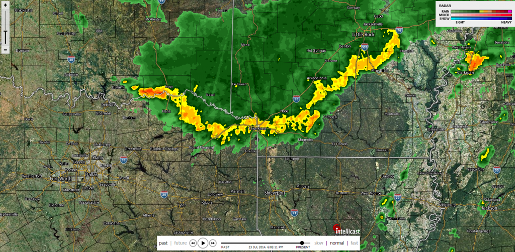
Texarkana just received a wind gust of 70mph and heavy rain with a line of thunderstorms moving due south. It looks like a lot of east Texas communities will be affected by the line as it moves south.

0 likes
Re: Texas Summer - 2014
Portastorm wrote::uarrow:
While nothing is ever guaranteed in the weather business, I think you can feel fairly confident about the pattern change next week. All of the medium range models for several days now have been showing the re-development of the pattern we saw last week: strong ridge in the west and deep trough in the east. Look for a "cool" front and increased rain for much of Texas starting the middle of next week.
Agreed, unlike winter patterns summer is rather easy to predict with a slower jet stream. Often the weather is stale and unchanging and when you do see change it tends to occur because it doesn't take much to flip it. Just got to wait to fine tune the details.
0 likes
The above post and any post by Ntxw is NOT an official forecast and should not be used as such. It is just the opinion of the poster and may or may not be backed by sound meteorological data. It is NOT endorsed by any professional institution including Storm2k. For official information, please refer to NWS products.
Help support Storm2K!
Help support Storm2K!
Re: Texas Summer - 2014
From the CPC. Makes you think of winter  PWC mets been getting some practice, can we dub it severe summer cold outbreak?

0 likes
The above post and any post by Ntxw is NOT an official forecast and should not be used as such. It is just the opinion of the poster and may or may not be backed by sound meteorological data. It is NOT endorsed by any professional institution including Storm2k. For official information, please refer to NWS products.
Help support Storm2K!
Help support Storm2K!

Is the WSI tanking ?
0 likes
The above post and any post by dhweather is NOT an official forecast and should not be used as such. It is just the opinion of the poster and may or may not be backed by sound meteorological data. It is NOT endorsed by any professional institution including storm2k.org. For official information, please refer to NWS products.
Re:
dhweather wrote:Is the WSI tanking ?
It and natural gas!
WSI outlook
Serious note the fall of natural gas is beneficial to us. ERCOT is having a pretty nice savings summer this year, nice reprieve from the past few of course typically reflects to savings for us.
0 likes
The above post and any post by Ntxw is NOT an official forecast and should not be used as such. It is just the opinion of the poster and may or may not be backed by sound meteorological data. It is NOT endorsed by any professional institution including Storm2k. For official information, please refer to NWS products.
Help support Storm2K!
Help support Storm2K!
-
Ralph's Weather
- S2K Supporter

- Posts: 3371
- Age: 38
- Joined: Fri Dec 13, 2013 11:55 am
- Location: Lindale, TX
- Contact:
We had some strong winds and a 10+ degree temp drop with the outflow boundary then heavy rain. It is still raining and looks to continue for a while. It was enough to knock out our power.
0 likes
Follow on Facebook at Ralph's Weather.
-
WeatherGuesser
- Category 5
- Posts: 2672
- Joined: Tue Jun 29, 2010 6:46 am
Re: Re:
Ntxw wrote:Serious note the fall of natural gas is beneficial to us. ERCOT is having a pretty nice savings summer this year, nice reprieve from the past few of course typically reflects to savings for us.
I keep seeing that, but there can't be anywhere near the demand in summer. Cooking, water heaters, some vehicles is about all on the residential end. Then there's food service and industrial usage that shouldn't change too much seasonally.
0 likes
Re: Re:
WeatherGuesser wrote:Ntxw wrote:Serious note the fall of natural gas is beneficial to us. ERCOT is having a pretty nice savings summer this year, nice reprieve from the past few of course typically reflects to savings for us.
I keep seeing that, but there can't be anywhere near the demand in summer. Cooking, water heaters, some vehicles is about all on the residential end. Then there's food service and industrial usage that shouldn't change too much seasonally.
Many of Texas energy companies use natural gas to produce electricity to supplement wind, and other sources. For a state that uses nonstop AC it can add up to a very good sum of savings as a collective whole, especially those who are not on a fixed rate (unlike some other areas of the country Texas' has deregulation). Up north and east there is not as much an influence because they do not use as much AC.
I think your assumption is natural gas is something for winter and heating, however it is also used to produce electricity.
0 likes
The above post and any post by Ntxw is NOT an official forecast and should not be used as such. It is just the opinion of the poster and may or may not be backed by sound meteorological data. It is NOT endorsed by any professional institution including Storm2k. For official information, please refer to NWS products.
Help support Storm2K!
Help support Storm2K!
Return to “USA & Caribbean Weather”
Who is online
Users browsing this forum: A1A, Cpv17, Stratton23, txtwister78 and 178 guests