
Tropical Wave in Eastern Atlantic
Moderator: S2k Moderators
Forum rules

The posts in this forum are NOT official forecasts and should not be used as such. They are just the opinion of the poster and may or may not be backed by sound meteorological data. They are NOT endorsed by any professional institution or STORM2K. For official information, please refer to products from the National Hurricane Center and National Weather Service.
-
cycloneye

- Admin

- Posts: 149550
- Age: 69
- Joined: Thu Oct 10, 2002 10:54 am
- Location: San Juan, Puerto Rico
Re: Tropical Wave in Eastern Atlantic
Saved image at 18:15 UTC.
0 likes
Visit the Caribbean-Central America Weather Thread where you can find at first post web cams,radars
and observations from Caribbean basin members Click Here
and observations from Caribbean basin members Click Here
-
JonathanBelles
- Professional-Met

- Posts: 11430
- Age: 35
- Joined: Sat Dec 24, 2005 9:00 pm
- Location: School: Florida State University (Tallahassee, FL) Home: St. Petersburg, Florida
- Contact:
Ceye,
This is also mentioned in P07L, and the NHC position at the time looks to be in between the two. Here is the synopsis:
SYNOPSIS 2014072600
P07L
13N, 28W
700 hPa
NHC has a 0%/20% (2/5 day) formation outlook, but it is located more in the moist ITCZ to the southeast of the P07L position. I am initiating that “area” as P09L because the models eventually develop a separate circulation there.
ECMWF: Distinct 700-hPa pouch is easy to track for 60 hours as it moves slowly and somewhat erratically to the west, gradually dissipating.
GFS: Similar start to ECMWF, and also lasts 60 hours, but it is a little weaker.
UKMET: Similar to GFS. Weakens to an inverted-V trough after a couple days.
NAVGEM: Tracks slowly, partly because it nearly dissipates, stalls, and then redevelops as a pouch on Day 2.
HWRF-GEN:
Code: Select all
ECMWF   -5.7    v700       60h
GFS     -6.7    v700             60h
UKMET   -5.4    v700       72h
NAVGEM  -5.5   v700       96h
HWGEN   ————   ————      ———h
0 likes
-
cycloneye
- Admin
- Posts: 149550
- Age: 69
- Joined: Thu Oct 10, 2002 10:54 am
- Location: San Juan, Puerto Rico
Re: Tropical Wave in Eastern Atlantic
P08L
8N, 5W
700 hPa
ECMWF: A weak pouch in analysis weakens until an equally weak pouch redevelops at 72 hours. ECMWF depicts both P08L and the new P09L to the west, but both are weak (with P09L not lasting to 120 hours).
GFS: Reasonably consistent start with yesterday, with a pouch in the analysis that quickly weakens. At 84 hours, pouch develops in the ITCZ. Note: Today’s GFS now indicates the development of P09L, to the west of and stronger than P08L. GFS has the strongest signature of this new pouch.
UKMET: Similar first three days to GFS, with a pouch redeveloping at 72 hours. UKMET also develops P09L to the west, but UKMET favors P08L rather than P09L.
NAVGEM: Strongest depiction. Uncertain period is shortest of the models (only the 24-48 hour period). Tracks westward at a higher latitude than the other models. P09L to the west is barely an OW max.
Code: Select all
HWRF-GEN:

ECMWF   -8.2     TPW      120h
GFS     -8.5    v700            120h
UKMET   -6.6    v700      120h
NAVGEM  -5.8   v700      120h
HWGEN   ————   ————      ———h
http://www.met.nps.edu/~mtmontgo/storms2014/P08L.html
0 likes
Visit the Caribbean-Central America Weather Thread where you can find at first post web cams,radars
and observations from Caribbean basin members Click Here
and observations from Caribbean basin members Click Here
Re: Tropical Wave in Eastern Atlantic
Interesting discussion as usual from Mark Sudduth on hurricanetrack.com -
"It’s not much to look at now, but the NHC has mentioned a tropical wave over the far eastern Atlantic that has some potential for development over the next few days.
Right now, the environment is not very suitable for anything to get going but that may change as indicated by some of the global computer models. A more favorable upward motion pattern, coupled with less dry air (perhaps) just might allow for a tropical low and eventually a depression to develop. It is close enough to August that this scenario seems plausible, especially considering the fact that TD2 formed within this general region just a few days ago. Even though that depression literally dried up, it is still a sign that this part of the deep tropics is becoming more and more favorable.
On the other hand, there has been an overwhelming amount of dry air across this region for a good part of the hurricane season to date. If this pattern does not ease up, it will be extremely difficult to believe that much will come out of the area south of 20N between Africa and the Lesser Antilles. All it takes is a few weeks of less hostile conditions and the lid could come off but for now, I am skeptical of seeing much – we’ll see what happens in the coming days.
Elsewhere, the Atlantic Basin is quiet this weekend."
http://hurricanetrack.com/
0 likes
-
wxman57

- Moderator-Pro Met

- Posts: 23175
- Age: 68
- Joined: Sat Jun 21, 2003 8:06 pm
- Location: Houston, TX (southwest)
Re: Tropical Wave in Eastern Atlantic
Environment in its path looks quite hostile. Might have a shot at a short run of being a TD like #2, but that may be about it.
0 likes
-
TropicalAnalystwx13

- Category 5

- Posts: 2109
- Age: 28
- Joined: Tue Jul 19, 2011 8:20 pm
- Location: Wilmington, NC
- Contact:
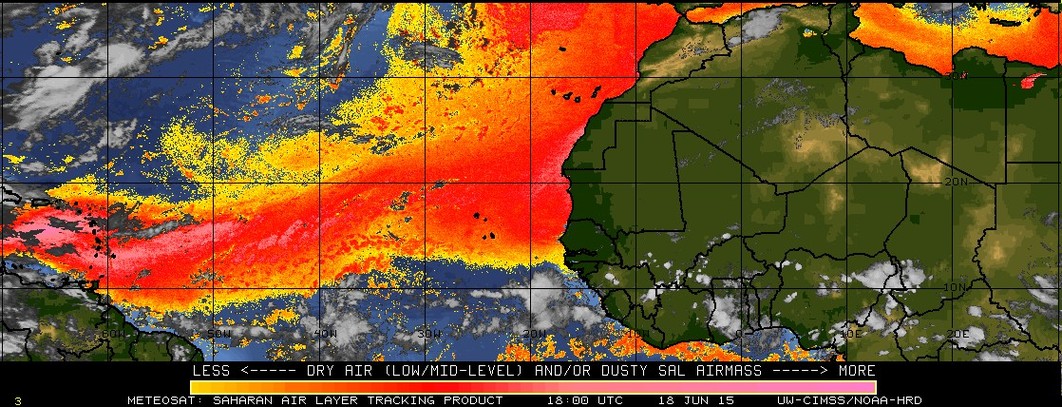
Would not at all be surprised to see this become Tropical Storm Bertha. The upper-air pattern should become increasingly favorable as this wave heads west-northwest, and looks to remain favorable up until the Caribbean Sea. There is an abundance of SAL and dry air across the tropical Atlantic right now, yes, but much like Tropical Depression Two, this wave will have the aid of a strong convectively-coupled kelvin wave (this is what has triggered so many disturbances in the West, Central, and East Pacific as of late) and a weak upward MJO signal to work with.
0 likes
-
SFLcane

- S2K Supporter

- Posts: 10281
- Age: 48
- Joined: Sat Jun 05, 2010 1:44 pm
- Location: Lake Worth Florida
Re: Tropical Wave in Eastern Atlantic
Few links...models hinting at busier times ahead in early aug we shall see.
http://rammb.cira.colostate.edu/ramsdis ... display=12
http://mp1.met.psu.edu/~fxg1/SAT_TROPAT ... im8ir.html
http://tropic.ssec.wisc.edu/real-time/w ... sghrd.html
http://tropic.ssec.wisc.edu/real-time/w ... sghrd.html
http://rammb.cira.colostate.edu/ramsdis ... display=12
http://mp1.met.psu.edu/~fxg1/SAT_TROPAT ... im8ir.html
http://tropic.ssec.wisc.edu/real-time/w ... sghrd.html
http://tropic.ssec.wisc.edu/real-time/w ... sghrd.html
0 likes
-
cycloneye
- Admin
- Posts: 149550
- Age: 69
- Joined: Thu Oct 10, 2002 10:54 am
- Location: San Juan, Puerto Rico
Re: Tropical Wave in Eastern Atlantic
18z GFS backed off.
0 likes
Visit the Caribbean-Central America Weather Thread where you can find at first post web cams,radars
and observations from Caribbean basin members Click Here
and observations from Caribbean basin members Click Here
-
ninel conde
Re: Tropical Wave in Eastern Atlantic
cycloneye wrote:18z GFS backed off.
not a suprprise. conditions are horrid and while some models say things might get a little less hostile ill have to see it to believe it.
0 likes
-
cycloneye
- Admin
- Posts: 149550
- Age: 69
- Joined: Thu Oct 10, 2002 10:54 am
- Location: San Juan, Puerto Rico
Re: Tropical Wave in Eastern Atlantic
TROPICAL WEATHER OUTLOOK
NWS NATIONAL HURRICANE CENTER MIAMI FL
800 PM EDT SAT JUL 26 2014
For the North Atlantic...Caribbean Sea and the Gulf of Mexico:
A tropical wave located to the southwest of the Cape Verde Islands
is moving westward at 10 to 15 mph. Although the system is
currently disorganized, environmental conditions may allow for the
gradual development of an area of low pressure over the central
tropical Atlantic by the middle of next week.
* Formation chance through 48 hours...low...near 0 percent
* Formation chance through 5 days...low...20 percent
$$
Forecaster Zelinsky/Beven
0 likes
Visit the Caribbean-Central America Weather Thread where you can find at first post web cams,radars
and observations from Caribbean basin members Click Here
and observations from Caribbean basin members Click Here

Re: Tropical Wave in Eastern Atlantic
Several are pointing out how dry the MRD is at the moment, and while I don't think we'll have anything close to a hyperactive season, going by June/July activity is not the best indicator of activity as 2010 at the same point looked even worse.
http://www.ncdc.noaa.gov/gibbs/image/GOE-12/IR/2010-07-26-18
http://www.ncdc.noaa.gov/gibbs/image/GOE-12/IR/2010-07-26-18
0 likes
The above post is not official and should not be used as such. It is the opinion of the poster and may or may not be backed by sound meteorological data. It is not endorsed by any professional institution or storm2k.org. For official information, please refer to the NHC and NWS products.
-
gatorcane

- S2K Supporter
- Posts: 23708
- Age: 48
- Joined: Sun Mar 13, 2005 3:54 pm
- Location: Boca Raton, FL
No doubt conditions are still hostile in the MDR for this tropical wave, but there are hints from the models that conditions may be improving as we head into August. This time last year the models were dead even through the long-range.
Take a look at the Mimic Total Precipitable Water loops form 1 week ago (top animation) and current (bottom animation) and note the increase in moisture especially over the Eastern Atlantic (more deeper oranges in the current animation especially towards the very end).
1 week ago:

Current:

Take a look at the Mimic Total Precipitable Water loops form 1 week ago (top animation) and current (bottom animation) and note the increase in moisture especially over the Eastern Atlantic (more deeper oranges in the current animation especially towards the very end).
1 week ago:
Current:
0 likes
-
Hurricaneman

- Category 5
- Posts: 7404
- Age: 45
- Joined: Tue Aug 31, 2004 3:24 pm
- Location: central florida
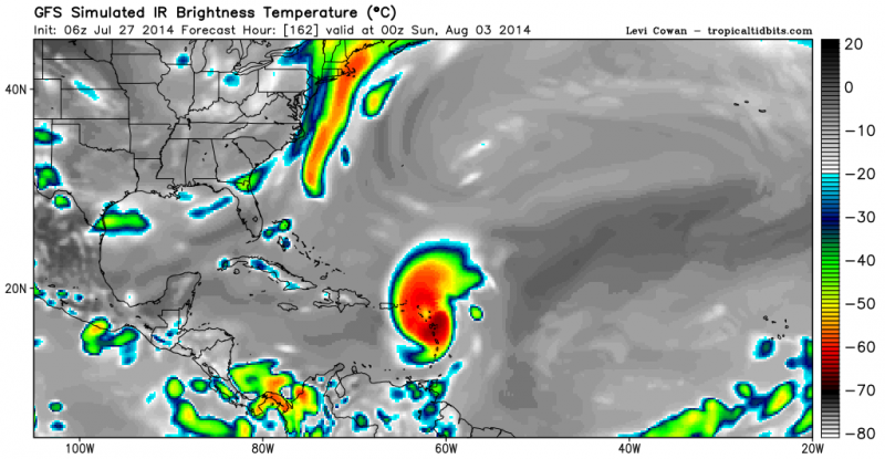
The 0zGFS seems to be pretty bullish on this one but has to be taken with a grain of salt due to its recent performance but it does have model support for at least some from of tropical system
at 168 is a threat to the lesser Antilles so interest in the northern windward islands need to monitor the progress of this system whether or not it develops
The posts in this forum are NOT official forecast and should not be used as such. They are just the opinion of the poster and may or may not be backed by sound meteorological data. They are NOT endorsed by any professional institution or storm2k.org. For official information, please refer to the NHC and NWS products
0 likes
-
TheStormExpert
Up to 40% in the 5-day. 
TROPICAL WEATHER OUTLOOK
NWS NATIONAL HURRICANE CENTER MIAMI FL
200 AM EDT SUN JUL 27 2014
For the North Atlantic...Caribbean Sea and the Gulf of Mexico:
A tropical wave located about 400 miles southwest of the Cape
Verde Islands is moving westward at 10 to 15 mph. Although shower
activity is currently disorganized, environmental conditions are
expected to become conducive for the development of an area of low
pressure over the central tropical Atlantic by the middle of this
week.
* Formation chance through 48 hours...low...near 0 percent.
* Formation chance through 5 days...medium...40 percent.
$$
Forecaster Stewart
0 likes
-
cycloneye
- Admin
- Posts: 149550
- Age: 69
- Joined: Thu Oct 10, 2002 10:54 am
- Location: San Juan, Puerto Rico
Re: Tropical Wave in Eastern Atlantic
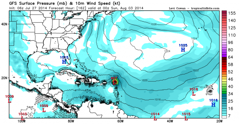
06z GFS run has a TS moving thru the NE Caribbean and then goes north of PR moving north to the west of Bermuda and more stronger.
0 likes
Visit the Caribbean-Central America Weather Thread where you can find at first post web cams,radars
and observations from Caribbean basin members Click Here
and observations from Caribbean basin members Click Here
-
cycloneye
- Admin
- Posts: 149550
- Age: 69
- Joined: Thu Oct 10, 2002 10:54 am
- Location: San Juan, Puerto Rico
Re: Tropical Wave in Eastern Atlantic
TROPICAL WEATHER OUTLOOK
NWS NATIONAL HURRICANE CENTER MIAMI FL
800 AM EDT SUN JUL 27 2014
For the North Atlantic...Caribbean Sea and the Gulf of Mexico:
A tropical wave is located about 420 miles southwest of the Cape
Verde Islands. The associated shower activity is limited
and disorganized, and development should be slow to occur over the
next couple of days. By the middle of this week, however,
environmental conditions are expected to become conducive for
gradual development over the central tropical Atlantic as the
system moves westward at 10 to 15 mph.
* Formation chance through 48 hours...low...near 0 percent.
* Formation chance through 5 days...medium...40 percent.
$$
Forecaster Roberts
0 likes
Visit the Caribbean-Central America Weather Thread where you can find at first post web cams,radars
and observations from Caribbean basin members Click Here
and observations from Caribbean basin members Click Here


Re: Tropical Wave in Eastern Atlantic
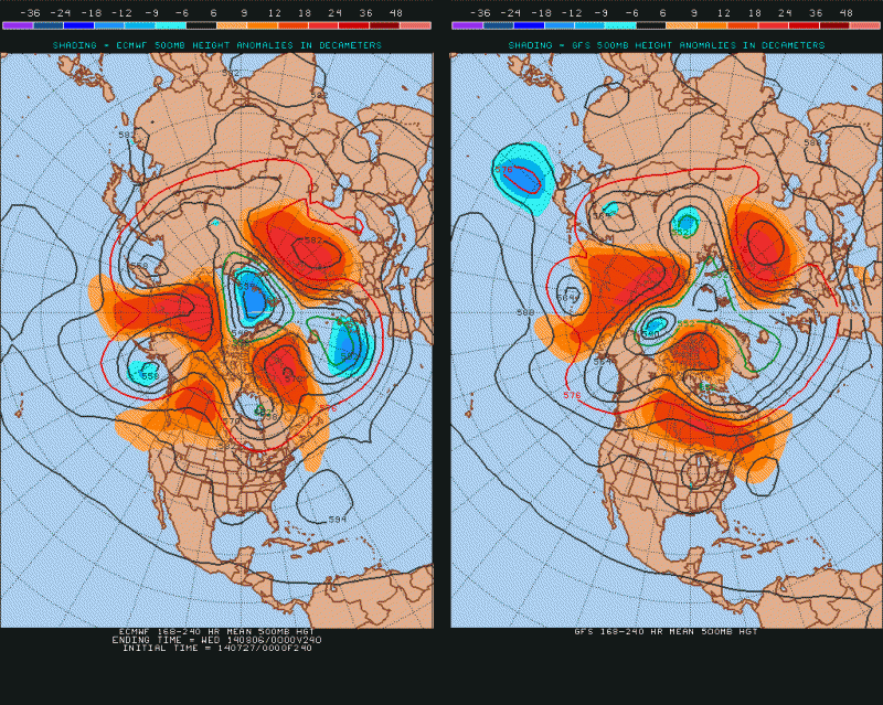
Nothing yet from King Euro but if we do see tropical development in central Atlantic and it survives the conditions both the GFS and Euro show a massive Bermuda ridge building in 7-10 day range if not longer.
0 likes
-
tropicwatch

- Category 5
- Posts: 3426
- Age: 62
- Joined: Sat Jun 02, 2007 10:01 am
- Location: The Villages, Florida
- Contact:
Re: Tropical Wave in Eastern Atlantic
The dry air is lessening considerably, this area might do better then TD2 did.
0 likes
Tropicwatch
Agnes 72', Eloise 75, Elena 85', Kate 85', Charley 86', Florence 88', Beryl 94', Dean 95', Erin 95', Opal 95', Earl 98', Georges 98', Ivan 2004', Arlene 2005', Dennis 2005', Ida 2009' Debby 2012' Irma 2017' Michael 2018'
Agnes 72', Eloise 75, Elena 85', Kate 85', Charley 86', Florence 88', Beryl 94', Dean 95', Erin 95', Opal 95', Earl 98', Georges 98', Ivan 2004', Arlene 2005', Dennis 2005', Ida 2009' Debby 2012' Irma 2017' Michael 2018'
Who is online
Users browsing this forum: No registered users and 90 guests