Tropical Wave in Eastern Atlantic
Moderator: S2k Moderators
Forum rules

The posts in this forum are NOT official forecasts and should not be used as such. They are just the opinion of the poster and may or may not be backed by sound meteorological data. They are NOT endorsed by any professional institution or STORM2K. For official information, please refer to products from the National Hurricane Center and National Weather Service.
Re: Tropical Wave in Eastern Atlantic
While the convection in the ITCZ might be weak it is present. It might be indicating future activity.
0 likes
-
Dean4Storms
- S2K Supporter

- Posts: 6358
- Age: 63
- Joined: Sun Aug 31, 2003 1:01 pm
- Location: Miramar Bch. FL
-
wxman57

- Moderator-Pro Met

- Posts: 23175
- Age: 68
- Joined: Sat Jun 21, 2003 8:06 pm
- Location: Houston, TX (southwest)
Re: Tropical Wave in Eastern Atlantic
The Caribbean looks much more hostile than the Atlantic. Lower-level winds have been in the 25-35 kt range for quite a while. With a deep trof along the East U.S. Coast next week, a track north of the Caribbean looks most likely. GFS solution/track looks good to me.
0 likes
-
SFLcane

- S2K Supporter
- Posts: 10281
- Age: 48
- Joined: Sat Jun 05, 2010 1:44 pm
- Location: Lake Worth Florida
Re: Tropical Wave in Eastern Atlantic
Very little chance bertha would have an impact on the US pretty substational trof waiting for it should recurve what ever develops.

0 likes

Re: Tropical Wave in Eastern Atlantic
SFLcane wrote:Very little chance bertha would have an impact on the US pretty substational trof waiting for it should recurve what ever develops.
http://i59.tinypic.com/282geox.png[/img]
That trough is going to lift out by the time the system gets closer. The Euro has a strong ridge over Bermuda building in late in the run around time our wave might be around Puerto Rico.
0 likes
The following post is NOT an official forecast and should not be used as such. It is just the opinion of the poster and may or may not be backed by sound meteorological data. It is NOT endorsed by any professional institution including storm2k.org For Official Information please refer to the NHC and NWS products.
-
SFLcane
- S2K Supporter
- Posts: 10281
- Age: 48
- Joined: Sat Jun 05, 2010 1:44 pm
- Location: Lake Worth Florida
Re: Tropical Wave in Eastern Atlantic
Blp pattern just has not been conducive for landfalls last few yrs for what ever reason. Still plenty of time to watch this one IF it even develops i've lost all hope in this basin cant even put out a decent capeverde storm to track just garbage storms way up there in the middle of no were.
0 likes

Re: Tropical Wave in Eastern Atlantic
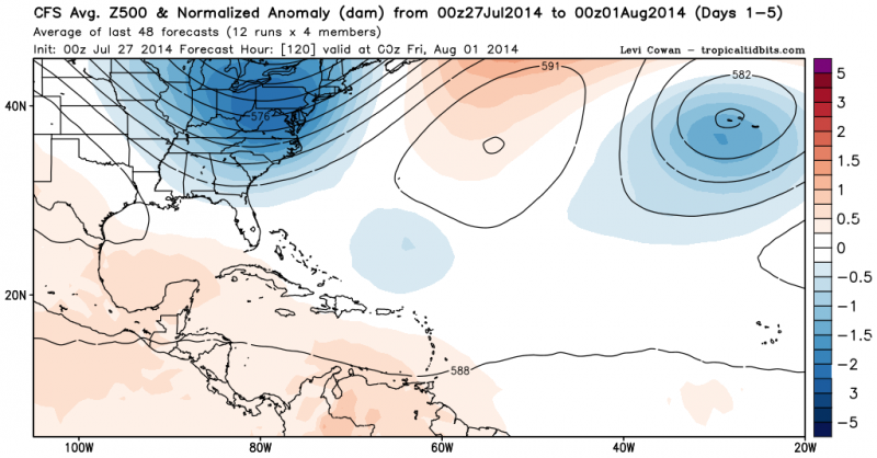
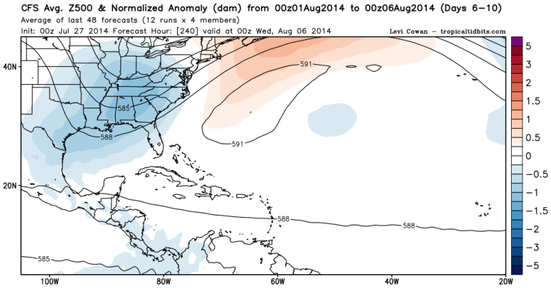
CFS also agrees with heights building across Bermuda.
0 likes
-
gatorcane

- S2K Supporter
- Posts: 23708
- Age: 48
- Joined: Sun Mar 13, 2005 3:54 pm
- Location: Boca Raton, FL
Re: Tropical Wave in Eastern Atlantic
SFLcane wrote:Blp pattern just has not been conducive for landfalls last few yrs for what ever reason. Still plenty of time to watch this one IF it even develops i've lost all hope in this basin cant even put out a decent capeverde storm to track just garbage storms way up there in the middle of no were.
Definitely too early to say where this would end up if it develops. I do see the globals hinting at a building Bermuda High ridge after the anomalously large trough over Eastern North America pulls out next weekend / early next week. For example, take a look at the 00Z GFS 500MB Height anomalies loop and look around 180 hours and beyond:
http://www.tropicaltidbits.com/analysis ... a_atl.html
One thing that is different from previous recent years are the anomalously strong troughs we are seeing in July over Eastern North America - I don't remember troughs this strong in July. Could this mean a long-wave pattern change come Aug/Sept which would open the door?
Last edited by gatorcane on Sun Jul 27, 2014 10:23 am, edited 5 times in total.
0 likes
-
tropicwatch

- Category 5

- Posts: 3426
- Age: 62
- Joined: Sat Jun 02, 2007 10:01 am
- Location: The Villages, Florida
- Contact:
It is odd for fronts to make it through the Panhandle and eastward this time of year. A more normal pattern might still happen, the summer still has a couple of months to go.
0 likes
Tropicwatch
Agnes 72', Eloise 75, Elena 85', Kate 85', Charley 86', Florence 88', Beryl 94', Dean 95', Erin 95', Opal 95', Earl 98', Georges 98', Ivan 2004', Arlene 2005', Dennis 2005', Ida 2009' Debby 2012' Irma 2017' Michael 2018'
Agnes 72', Eloise 75, Elena 85', Kate 85', Charley 86', Florence 88', Beryl 94', Dean 95', Erin 95', Opal 95', Earl 98', Georges 98', Ivan 2004', Arlene 2005', Dennis 2005', Ida 2009' Debby 2012' Irma 2017' Michael 2018'
-
cycloneye

- Admin

- Posts: 149550
- Age: 69
- Joined: Thu Oct 10, 2002 10:54 am
- Location: San Juan, Puerto Rico
Re: Tropical Wave in Eastern Atlantic
The beginning.

0 likes
Visit the Caribbean-Central America Weather Thread where you can find at first post web cams,radars
and observations from Caribbean basin members Click Here
and observations from Caribbean basin members Click Here
-
gatorcane
- S2K Supporter
- Posts: 23708
- Age: 48
- Joined: Sun Mar 13, 2005 3:54 pm
- Location: Boca Raton, FL
Nice image cycloneye. Looking at the latest satellite loops of the area this morning, convection is on the increase with this wave though still disorganized. WV loops show lessening dry air across the MDR with the ITCZ firing which could be caused by the anticipated arrival of the MJO pulse into the Atlantic basin.
It's becoming clear there is more moisture around for this wave than TD #2 which should allow some slow development this coming week.
It's becoming clear there is more moisture around for this wave than TD #2 which should allow some slow development this coming week.
0 likes

Reasonable shot at getting Bertha out of this, decent looking conditions upto around 55-60W. After that there does seem to be higher shear, though this does lessen further north you get.
Track is a toughie, but I suspect a recurve around 65-70W will be the most likely if it goes on to develop like the GFS. If it doesn't develop soon enough, it will be destroyed in the Caribbean.
Track is a toughie, but I suspect a recurve around 65-70W will be the most likely if it goes on to develop like the GFS. If it doesn't develop soon enough, it will be destroyed in the Caribbean.
0 likes
Personal Forecast Disclaimer:
The posts in this forum are NOT official forecast and should not be used as such. They are just the opinion of the poster and may or may not be backed by sound meteorological data. They are NOT endorsed by any professional institution or storm2k.org. For official information, please refer to the NHC and NWS products
The posts in this forum are NOT official forecast and should not be used as such. They are just the opinion of the poster and may or may not be backed by sound meteorological data. They are NOT endorsed by any professional institution or storm2k.org. For official information, please refer to the NHC and NWS products
One thing I notice that a few have mentioned is how much moisture we are seeing in the MDR. These are some of the most favorable conditions we've seen in the MDR recently.
Fairly confident we won't be seeing a long track major storm though. I don't see the Caribbean getting much better anytime soon.
Fairly confident we won't be seeing a long track major storm though. I don't see the Caribbean getting much better anytime soon.
0 likes
-
AtlanticWind

- S2K Supporter
- Posts: 1898
- Age: 67
- Joined: Sun Aug 08, 2004 9:57 pm
- Location: Plantation,Fla

-
northjaxpro

- S2K Supporter
- Posts: 8900
- Joined: Mon Sep 27, 2010 11:21 am
- Location: Jacksonville, FL
Re:
RL3AO wrote:One thing I notice that a few have mentioned is how much moisture we are seeing in the MDR. These are some of the most favorable conditions we've seen in the MDR recently.
Fairly confident we won't be seeing a long track major storm though. I don't see the Caribbean getting much better anytime soon.
Definitely agree with you about this. The Caribbean has been heavy with shear all season long to this point, so any system approaching that region is just going to get ripped to shreads.
This wave has a shot to gradually develop the next 3-5 days. But even if it does, huge questions on whether or not it can survive hostile conditions past 55 degrees longitude.
Last edited by northjaxpro on Sun Jul 27, 2014 11:21 am, edited 1 time in total.
0 likes
NEVER, EVER SAY NEVER in the tropics and weather in general, and most importantly, with life itself!!
________________________________________________________________________________________
Fay 2008 Beryl 2012 Debby 2012 Colin 2016 Hermine 2016 Julia 2016 Matthew 2016 Irma 2017 Dorian 2019
________________________________________________________________________________________
Fay 2008 Beryl 2012 Debby 2012 Colin 2016 Hermine 2016 Julia 2016 Matthew 2016 Irma 2017 Dorian 2019

Yes more bullish in the 72-144hrs range, a stronger system should be able to escape out to sea, there is a ridge building in in the 9-10 day range but by that point a strong system may well be on the connecting route out to sea.
With that said, experience tells me that these systems tend to go further west when they form in this area than models expect andI suspect any recurve will be closer to 80W than 60W.
With that said, experience tells me that these systems tend to go further west when they form in this area than models expect andI suspect any recurve will be closer to 80W than 60W.
0 likes
Personal Forecast Disclaimer:
The posts in this forum are NOT official forecast and should not be used as such. They are just the opinion of the poster and may or may not be backed by sound meteorological data. They are NOT endorsed by any professional institution or storm2k.org. For official information, please refer to the NHC and NWS products
The posts in this forum are NOT official forecast and should not be used as such. They are just the opinion of the poster and may or may not be backed by sound meteorological data. They are NOT endorsed by any professional institution or storm2k.org. For official information, please refer to the NHC and NWS products
Who is online
Users browsing this forum: No registered users and 115 guests