
Tropical Wave in Eastern Atlantic
Moderator: S2k Moderators
Forum rules

The posts in this forum are NOT official forecasts and should not be used as such. They are just the opinion of the poster and may or may not be backed by sound meteorological data. They are NOT endorsed by any professional institution or STORM2K. For official information, please refer to products from the National Hurricane Center and National Weather Service.
-
cycloneye

- Admin

- Posts: 149550
- Age: 69
- Joined: Thu Oct 10, 2002 10:54 am
- Location: San Juan, Puerto Rico
Re: Tropical Wave in Eastern Atlantic
0 likes
Visit the Caribbean-Central America Weather Thread where you can find at first post web cams,radars
and observations from Caribbean basin members Click Here
and observations from Caribbean basin members Click Here

-
northjaxpro

- S2K Supporter

- Posts: 8900
- Joined: Mon Sep 27, 2010 11:21 am
- Location: Jacksonville, FL
It's all about timing and the strength of the system. A stronger cyclone would tend to feel the weakness and get pulled by the trough on out to sea. I still beleieve that even if this develops, conditions will not allow this to become a well developed and strong tropical cyclone. If this happens, then it would go farther west.
Lots of time to watch this, but I would say looking at GFS run above, that is a very unusually strong trough for this time of the year across Eastern North America. It would be tough to see this system not curving out to sea at this point. BUT, this definitely could change with time of course. I will wait to see the later EURO runs on if the trough either retrogrades or lifts out or not.
Lots of time to watch this, but I would say looking at GFS run above, that is a very unusually strong trough for this time of the year across Eastern North America. It would be tough to see this system not curving out to sea at this point. BUT, this definitely could change with time of course. I will wait to see the later EURO runs on if the trough either retrogrades or lifts out or not.
Last edited by northjaxpro on Sun Jul 27, 2014 11:34 am, edited 1 time in total.
0 likes
NEVER, EVER SAY NEVER in the tropics and weather in general, and most importantly, with life itself!!
________________________________________________________________________________________
Fay 2008 Beryl 2012 Debby 2012 Colin 2016 Hermine 2016 Julia 2016 Matthew 2016 Irma 2017 Dorian 2019
________________________________________________________________________________________
Fay 2008 Beryl 2012 Debby 2012 Colin 2016 Hermine 2016 Julia 2016 Matthew 2016 Irma 2017 Dorian 2019

The issue is if its too weak and gets to say 65W and isbelow 20N, then its going to be smashed to bits by the shear still in the area, for this system to become a strong system (above TS) its probably going to have to get north of 25N sooner rather than later.
For a system to hit the US, a few things are going to have to fall into place. Could happen but odds still against for now.
PS, pattern is shifting by 168hrs BUT the general broad pattern of an upper trough (more slated mind you) with the main thrust of HP further east is still in situ. Until that actually changes totally, your going to only get a variation on the recurve situation.
Last edited by KWT on Sun Jul 27, 2014 11:35 am, edited 1 time in total.
0 likes
Personal Forecast Disclaimer:
The posts in this forum are NOT official forecast and should not be used as such. They are just the opinion of the poster and may or may not be backed by sound meteorological data. They are NOT endorsed by any professional institution or storm2k.org. For official information, please refer to the NHC and NWS products
The posts in this forum are NOT official forecast and should not be used as such. They are just the opinion of the poster and may or may not be backed by sound meteorological data. They are NOT endorsed by any professional institution or storm2k.org. For official information, please refer to the NHC and NWS products
-
cycloneye
- Admin
- Posts: 149550
- Age: 69
- Joined: Thu Oct 10, 2002 10:54 am
- Location: San Juan, Puerto Rico
Re: Tropical Wave in Eastern Atlantic
Michael Ventrice @MJVentrice · 3m
Strong CCKW pushing across MDR this week.. Watch for tropical development after its passage
Strong CCKW pushing across MDR this week.. Watch for tropical development after its passage
0 likes
Visit the Caribbean-Central America Weather Thread where you can find at first post web cams,radars
and observations from Caribbean basin members Click Here
and observations from Caribbean basin members Click Here
-
northjaxpro
- S2K Supporter
- Posts: 8900
- Joined: Mon Sep 27, 2010 11:21 am
- Location: Jacksonville, FL
Re: Tropical Wave in Eastern Atlantic
Oh yeah, for this system to have any significant odds of surviving, it must stay north of tthe Caribbean for sure. However, I don't foresee conditions much better for it even if it tracks north of the Caribbean. I could be wrong, but I still think conditions will not allow it to get very strong beyond 5 days.
Last edited by northjaxpro on Sun Jul 27, 2014 11:41 am, edited 1 time in total.
0 likes
NEVER, EVER SAY NEVER in the tropics and weather in general, and most importantly, with life itself!!
________________________________________________________________________________________
Fay 2008 Beryl 2012 Debby 2012 Colin 2016 Hermine 2016 Julia 2016 Matthew 2016 Irma 2017 Dorian 2019
________________________________________________________________________________________
Fay 2008 Beryl 2012 Debby 2012 Colin 2016 Hermine 2016 Julia 2016 Matthew 2016 Irma 2017 Dorian 2019


Re: Tropical Wave in Eastern Atlantic
I am waiting for the Euro to jump in before I consider the recurve scenario. I have a feeling the Euro will have a different take since from what I have seen on the past few runs it shows the ridge building in quicker and stronger than the GFS.
0 likes
The following post is NOT an official forecast and should not be used as such. It is just the opinion of the poster and may or may not be backed by sound meteorological data. It is NOT endorsed by any professional institution including storm2k.org For Official Information please refer to the NHC and NWS products.


-
cycloneye
- Admin
- Posts: 149550
- Age: 69
- Joined: Thu Oct 10, 2002 10:54 am
- Location: San Juan, Puerto Rico
Re: Tropical Wave in Eastern Atlantic
NAVGEM has hurricane in Central Antilles.
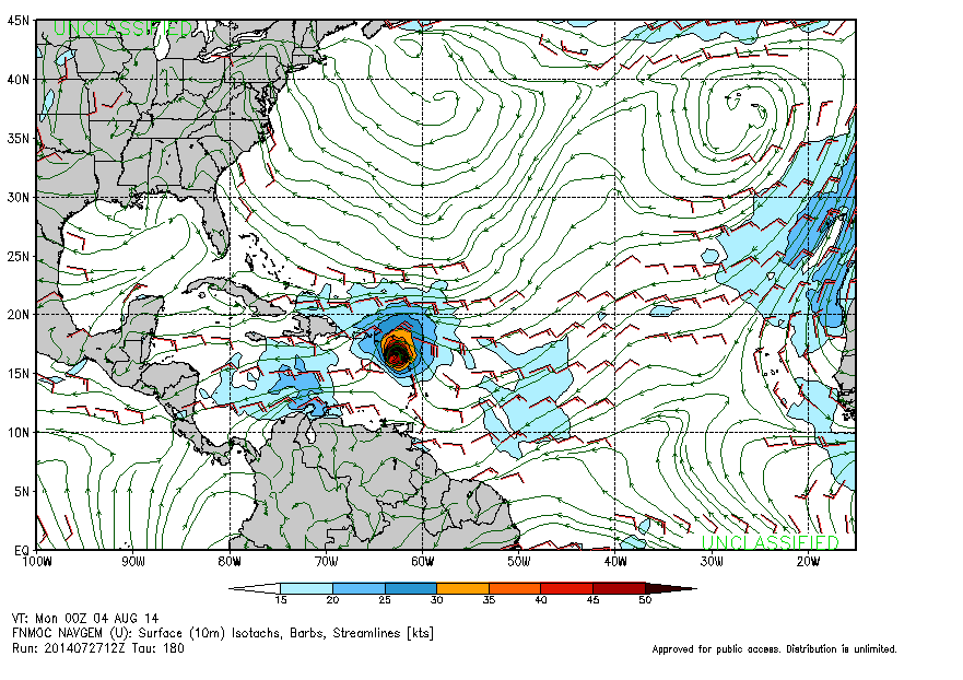
0 likes
Visit the Caribbean-Central America Weather Thread where you can find at first post web cams,radars
and observations from Caribbean basin members Click Here
and observations from Caribbean basin members Click Here
Re:
gatorcane wrote:12Z GEM running and has the system finally so let's see what it does with it. 84 hours below:
http://i59.tinypic.com/6hn8t5.jpg[/img]
0 likes
The following post is NOT an official forecast and should not be used as such. It is just the opinion of the poster and may or may not be backed by sound meteorological data. It is NOT endorsed by any professional institution including storm2k.org For Official Information please refer to the NHC and NWS products.
-
gatorcane

- S2K Supporter
- Posts: 23708
- Age: 48
- Joined: Sun Mar 13, 2005 3:54 pm
- Location: Boca Raton, FL
Re: Tropical Wave in Eastern Atlantic
cycloneye wrote:NAVGEM has hurricane in Central Antilles
Wow - very bullish - GEM is through the Central Antilles also. GFS is the northern most model right now. It was also right-biased with TD #2...I hope the Euro picks up on this system on the 12Z so we can see what it does with it.
12Z GEM has finished running. It brings it through Puerto Rico/Hispaniola SE Bahamas and off the U.S. east coast between the U.S and Bermuda - so recurve like GFS but quite a bit further west.
Closest point to U.S. on this run is couple of hundred miles east of Florida 192 hours from now:

0 likes
-
cycloneye
- Admin
- Posts: 149550
- Age: 69
- Joined: Thu Oct 10, 2002 10:54 am
- Location: San Juan, Puerto Rico
Re: Tropical Wave in Eastern Atlantic
12z GFS Ensembles.

0 likes
Visit the Caribbean-Central America Weather Thread where you can find at first post web cams,radars
and observations from Caribbean basin members Click Here
and observations from Caribbean basin members Click Here
-
gatorcane
- S2K Supporter
- Posts: 23708
- Age: 48
- Joined: Sun Mar 13, 2005 3:54 pm
- Location: Boca Raton, FL
Re: Tropical Wave in Eastern Atlantic
blp wrote:I am waiting for the Euro to jump in before I consider the recurve scenario. I have a feeling the Euro will have a different take since from what I have seen on the past few runs it shows the ridge building in quicker and stronger than the GFS.
Studying the models in the long-range, I see two camps with the models as far as long-range steering:
GFS/CMC - keep a trough over the U.S. east coast / Western Atlantic for basically the next 10 days
ECMWF/NAVGEM - build in the Bermuda High / Western Atlantic ridge in the 7-10 day timeframe
Going to be interesting to see which camp is right as it will make big difference as far as where any developing system from this wave ends up.
Also, GFS shows high shear remaining across the Central and Western Caribbean so conditions don't look good there for any development assuming a system were to head that way.
Last edited by gatorcane on Sun Jul 27, 2014 12:38 pm, edited 2 times in total.
0 likes
-
cycloneye
- Admin
- Posts: 149550
- Age: 69
- Joined: Thu Oct 10, 2002 10:54 am
- Location: San Juan, Puerto Rico
TROPICAL WEATHER OUTLOOK
NWS NATIONAL HURRICANE CENTER MIAMI FL
200 PM EDT SUN JUL 27 2014
For the North Atlantic...Caribbean Sea and the Gulf of Mexico:
A tropical wave is located several hundred miles southwest of the
Cape Verde Islands. The associated shower activity remains limited
and disorganized, and development should be slow to occur over the
next couple of days. By the middle of this week, however,
environmental conditions are expected to become conducive for
gradual development over the central tropical Atlantic as the
system moves westward at 10 to 15 mph.
* Formation chance through 48 hours...low...near 0 percent.
* Formation chance through 5 days...medium...40 percent.
$$
Forecaster Roberts
0 likes
Visit the Caribbean-Central America Weather Thread where you can find at first post web cams,radars
and observations from Caribbean basin members Click Here
and observations from Caribbean basin members Click Here
-
cycloneye
- Admin
- Posts: 149550
- Age: 69
- Joined: Thu Oct 10, 2002 10:54 am
- Location: San Juan, Puerto Rico
Re: Tropical Wave in Eastern Atlantic
Look how the 5 day track that NHC has at 2 PM bends at the end.

0 likes
Visit the Caribbean-Central America Weather Thread where you can find at first post web cams,radars
and observations from Caribbean basin members Click Here
and observations from Caribbean basin members Click Here
-
TropicalAnalystwx13

- Category 5

- Posts: 2109
- Age: 28
- Joined: Tue Jul 19, 2011 8:20 pm
- Location: Wilmington, NC
- Contact:
The Caribbean is a death trap for tropical cyclones. If this enters the Caribbean, it'll be torn apart by strong upper-level westerlies coupled with fast easterly trade winds.
We'll get much more of this system if it moves north of the islands. Fortunately for us, the 500mb pattern shows a huge weakness in the north-central Atlantic, which should allow the storm to gain appreciable latitude.
We'll get much more of this system if it moves north of the islands. Fortunately for us, the 500mb pattern shows a huge weakness in the north-central Atlantic, which should allow the storm to gain appreciable latitude.
0 likes
-
northjaxpro
- S2K Supporter
- Posts: 8900
- Joined: Mon Sep 27, 2010 11:21 am
- Location: Jacksonville, FL
Re: Tropical Wave in Eastern Atlantic
gatorcane wrote:blp wrote:I am waiting for the Euro to jump in before I consider the recurve scenario. I have a feeling the Euro will have a different take since from what I have seen on the past few runs it shows the ridge building in quicker and stronger than the GFS.
Studying the models in the long-range, I see two camps with the models as far as long-range steering:
GFS/CMC - keep a trough over the U.S. east coast / Western Atlantic for basically the next 10 days
ECMWF/NAVGEM - build in the Bermuda High / Western Atlantic ridge in the 7-10 day timeframe
Going to be interesting to see which camp is right as it will make big difference as far as where any developing system from this wave ends up.
Also, GFS shows high shear remaining across the Central and Western Caribbean so conditions don't look good there for any development assuming a system were to head that way.
Gatorcane, this basically sums it up in a nutshell, provided if our wave develops in a few days.
0 likes
NEVER, EVER SAY NEVER in the tropics and weather in general, and most importantly, with life itself!!
________________________________________________________________________________________
Fay 2008 Beryl 2012 Debby 2012 Colin 2016 Hermine 2016 Julia 2016 Matthew 2016 Irma 2017 Dorian 2019
________________________________________________________________________________________
Fay 2008 Beryl 2012 Debby 2012 Colin 2016 Hermine 2016 Julia 2016 Matthew 2016 Irma 2017 Dorian 2019
-
cycloneye
- Admin
- Posts: 149550
- Age: 69
- Joined: Thu Oct 10, 2002 10:54 am
- Location: San Juan, Puerto Rico
Re: Tropical Wave in Eastern Atlantic
Here is a discussion made this afternoon by Dr Jeff Masters about this potential area.
http://www.wunderground.com/blog/JeffMa ... #commentop
An area of disturbed weather near 11°N, 31°W, about 500 miles southwest of the Cape Verde Islands, has the potential to develop into a tropical depression later this week as it heads west at 10 - 15 mph towards the Lesser Antilles Islands. Visible satellite loops on Sunday morning showed that the disturbance had only a minor amount of spin. Infrared satellite images showed that the system's heavy thunderstorm activity was modest at best, and had not changed significantly since Saturday. Wind shear was moderate, 10 - 15 knots, which should allow slow development. Ocean temperatures were marginal for development, about 27°C. Water vapor satellite loops showed that the atmosphere was reasonably moist in the area, though a large area of dry air lay a few hundred miles to the north.
Forecast for the disturbance
Two of our three reliable models for predicting tropical cyclone genesis, the GFS and UKMET models, predicted in their 00Z Sunday runs that the disturbance would develop into a tropical depression by Thursday. Several of our less reliable models, the NAVGEM and Canadian models, also predicted development. The only reliable model that did not predict development was the European model, which historically has had the highest incidence of failing to predict development when development actually occurs. The fact that two out of three of the reliable genesis models predict development bolsters the odds that development will actually occur. In their 2 pm EDT Sunday Tropical Weather Outlook, NHC put the 5-day odds of development at 40%, up from their 20% forecast from Saturday evening.
All of the models predict that the disturbance will continue due west or just north of due west at 10 - 15 mph for the next five days. The UKMET is the fastest of the models, predicting that the disturbance will arrive in the Lesser Antilles Islands on Friday. The GFS is slower, predicting a Saturday arrival in the islands. Once the disturbance crosses west of about 50°W longitude, ocean temperatures will warm to about 28°C, which should aid development. Dry air to the north will likely interfere with development by the middle of the week, and we will have to see if the moderate levels of wind shear forecast to occur over the tropical Atlantic will be capable of driving this dry air into the core of the system, disrupting formation. The disturbance may also have trouble disentangling itself from the Intertropical Convergence Zone (ITCZ), the band of heavy thunderstorms that circles the globe in the tropics, which lies just to the south of the disturbance. Clusters of thunderstorms in the ITCZ may compete for moisture and energy, slowing development of the disturbance. Most of the 20 members of the 06Z Sunday run of the GFS ensemble model (which runs the GFS model at low resolution 20 times with slightly different initial conditions to show a range of possible outcomes) showed the disturbance missing the U.S. East Coast and recurving out to sea early next week, but it is too early to assess the odds of this.
Jeff Masters
http://www.wunderground.com/blog/JeffMa ... #commentop
0 likes
Visit the Caribbean-Central America Weather Thread where you can find at first post web cams,radars
and observations from Caribbean basin members Click Here
and observations from Caribbean basin members Click Here
Who is online
Users browsing this forum: No registered users and 115 guests