ATL: BERTHA - Models
Moderator: S2k Moderators
-
South Texas Storms

- Professional-Met

- Posts: 4259
- Joined: Thu Jun 24, 2010 12:28 am
- Location: Houston, TX


Much weaker run from the 06z, which allows the system to get somewhat further west than in previous runs. Strong TS through LA still though. Also same pattern as last runs which is a W/WNW till about 60-70W then recurve pattern begins. Most models have a variation on that pattern.
0 likes
Personal Forecast Disclaimer:
The posts in this forum are NOT official forecast and should not be used as such. They are just the opinion of the poster and may or may not be backed by sound meteorological data. They are NOT endorsed by any professional institution or storm2k.org. For official information, please refer to the NHC and NWS products
The posts in this forum are NOT official forecast and should not be used as such. They are just the opinion of the poster and may or may not be backed by sound meteorological data. They are NOT endorsed by any professional institution or storm2k.org. For official information, please refer to the NHC and NWS products

Re: ATL: INVEST 93L - Models
The 00z Euro doesn't do much with it. However, it does show stronger ridging than the GFS in the SW Atlantic in the 7-9 day timeframe.
0 likes
Difference in timing is pretty amazing looking at the models. HWRF for example has 93L at 45W at 84hrs (roughly) whilst the ECM has whats left of the system around 55W. Thats a large difference in that short of a time frame.
The speed that the ECM is pushing it westwards may also have something to do with why it doesn't form it.
The longer it can take to get west the better as the shear is forecasted to reduce somewhat at the upper ridge builds a little stronger in the west Atlantic between 120-180hrs. Even so it must get north of the Caribbean if its going to do anything more than a sheared mess by that point.
Forward speed is the key!
0 likes
Personal Forecast Disclaimer:
The posts in this forum are NOT official forecast and should not be used as such. They are just the opinion of the poster and may or may not be backed by sound meteorological data. They are NOT endorsed by any professional institution or storm2k.org. For official information, please refer to the NHC and NWS products
The posts in this forum are NOT official forecast and should not be used as such. They are just the opinion of the poster and may or may not be backed by sound meteorological data. They are NOT endorsed by any professional institution or storm2k.org. For official information, please refer to the NHC and NWS products
-
cycloneye

- Admin

- Posts: 149508
- Age: 69
- Joined: Thu Oct 10, 2002 10:54 am
- Location: San Juan, Puerto Rico
Re: ATL: INVEST 93L - Models
06z GFS Ensembles.

0 likes
Visit the Caribbean-Central America Weather Thread where you can find at first post web cams,radars
and observations from Caribbean basin members Click Here
and observations from Caribbean basin members Click Here

I would not doubt to see the GFS keep trending westward during the upcoming days, it does not make any sense that it shows possible Bertha to plow through the forecasted Bermuda ridge.
The posts in this forum are NOT official forecast and should not be used as such. They are just the opinion of the poster and may or may not be backed by sound meteorological data. They are NOT endorsed by any professional institution or storm2k.org. For official information, please refer to the NHC and NWS products.
The posts in this forum are NOT official forecast and should not be used as such. They are just the opinion of the poster and may or may not be backed by sound meteorological data. They are NOT endorsed by any professional institution or storm2k.org. For official information, please refer to the NHC and NWS products.
0 likes
The thing is the pattern is STILL a east trough pattern, even on the ECM. There is a stronger upper high that tries to develop on the ECM but above 500mbs there is still a fairly healthy upper trough which is placed just far enough east to probably allow a safe recurve out to sea around 70-75W if the ECM is right.
If it stays weak and low, then its going to run into the shear wall, which is what appears to happen on the HWRF, which weakens the system a good deal by 120hrs compared to 84hrs.
GFS probably will trend a little west with time as its nearly always too far east due to being too aggressive with developing these types of systems.
0 likes
Personal Forecast Disclaimer:
The posts in this forum are NOT official forecast and should not be used as such. They are just the opinion of the poster and may or may not be backed by sound meteorological data. They are NOT endorsed by any professional institution or storm2k.org. For official information, please refer to the NHC and NWS products
The posts in this forum are NOT official forecast and should not be used as such. They are just the opinion of the poster and may or may not be backed by sound meteorological data. They are NOT endorsed by any professional institution or storm2k.org. For official information, please refer to the NHC and NWS products
-
Blown Away

- S2K Supporter

- Posts: 10253
- Joined: Wed May 26, 2004 6:17 am
Re: ATL: INVEST 93L - Models

93L's 72 hour forecasted position...
0 likes
Hurricane Eye Experience: David 79, Irene 99, Frances 04, Jeanne 04, Wilma 05… Hurricane Brush Experience: Andrew 92, Erin 95, Floyd 99, Matthew 16, Irma 17, Ian 22, Nicole 22…
-
tolakram
- Admin
- Posts: 20186
- Age: 62
- Joined: Sun Aug 27, 2006 8:23 pm
- Location: Florence, KY (name is Mark)
Re: ATL: INVEST 93L - Models
TCGEN: http://ruc.noaa.gov/hfip/tcgen/
Every model except the Euro has something. If you compare Day 3 vorticity the Euro also shows nothing.
I think this demonstrates just how much trouble the Euro has at developing storms in this area.
Every model except the Euro has something. If you compare Day 3 vorticity the Euro also shows nothing.
I think this demonstrates just how much trouble the Euro has at developing storms in this area.
0 likes
M a r k
- - - - -
Join us in chat: Storm2K Chatroom Invite. Android and IOS apps also available.
The posts in this forum are NOT official forecasts and should not be used as such. Posts are NOT endorsed by any professional institution or STORM2K.org. For official information and forecasts, please refer to NHC and NWS products.
I think ECM does show it, but it smashes it quite quickly to the west and kind of just loses the system as it all stretches out by day 3 as you say.
Seems a little unrealistic to be honest given what all the other models show.
Seems a little unrealistic to be honest given what all the other models show.
0 likes
Personal Forecast Disclaimer:
The posts in this forum are NOT official forecast and should not be used as such. They are just the opinion of the poster and may or may not be backed by sound meteorological data. They are NOT endorsed by any professional institution or storm2k.org. For official information, please refer to the NHC and NWS products
The posts in this forum are NOT official forecast and should not be used as such. They are just the opinion of the poster and may or may not be backed by sound meteorological data. They are NOT endorsed by any professional institution or storm2k.org. For official information, please refer to the NHC and NWS products
Re:
KWT wrote:The thing is the pattern is STILL a east trough pattern, even on the ECM. There is a stronger upper high that tries to develop on the ECM but above 500mbs there is still a fairly healthy upper trough which is placed just far enough east to probably allow a safe recurve out to sea around 70-75W if the ECM is right.
If it stays weak and low, then its going to run into the shear wall, which is what appears to happen on the HWRF, which weakens the system a good deal by 120hrs compared to 84hrs.
GFS probably will trend a little west with time as its nearly always too far east due to being too aggressive with developing these types of systems.
Are you seeing a different HWRF run?
I could only find this:
ATTENTION...NATIONAL HURRICANE CENTER
NCEP COUPLED HWRF HURRICANE MODEL FORECAST MADE FOR
TROPICAL DEPRESSION INVEST 93L
INITIAL TIME 6Z JUL 28
FORECAST POSITIONS
HOUR LATITUDE LONGITUDE MIN PRESS (hPa) MAX SFC WIND (KTS)
HOUR: 0.0 LONG: -31.20 LAT: 10.00 MIN PRES (hPa): 1013.00 MAX SURF WIND (KNOTS): 18.00
HOUR: 1.0 LONG: -31.60 LAT: 9.90 MIN PRES (hPa): 1014.00 MAX SURF WIND (KNOTS): 17.00
HOUR: 2.0 LONG: -31.30 LAT: 9.70 MIN PRES (hPa): 1014.00 MAX SURF WIND (KNOTS): 16.00
HOUR: 3.0 LONG: -31.90 LAT: 9.70 MIN PRES (hPa): 1014.00 MAX SURF WIND (KNOTS): 15.00
HOUR: 4.0 LONG: -32.10 LAT: 9.90 MIN PRES (hPa): 1015.00 MAX SURF WIND (KNOTS): 15.00
HOUR: 5.0 LONG: -32.10 LAT: 9.90 MIN PRES (hPa): 1015.00 MAX SURF WIND (KNOTS): 15.00
HOUR: 6.0 LONG: -32.40 LAT: 10.00 MIN PRES (hPa): 1015.00 MAX SURF WIND (KNOTS): 15.00
HOUR: 7.0 LONG: -32.50 LAT: 9.30 MIN PRES (hPa): 1016.00 MAX SURF WIND (KNOTS): 16.00
FORECAST RAN COUPLED FOR THE ENTIRE PERIOD...
STORM DISSIPATED AT 7 HOURS AT ABOVE POSITION.
DISCLAIMER ... THIS INFORMATION IS PROVIDED AS GUIDANCE. IT
REQUIRES INTERPRETATION BY HURRICANE SPECIALISTS AND SHOULD
NOT BE CONSIDERED AS A FINAL PRODUCT. PLEASE SEE THE NHC
OFFICIAL FORECAST.
0 likes
Its up on tropical tidbits NDG, here is a link for what it shows at 48hrs:
http://www.tropicaltidbits.com/analysis ... 93L_15.png
http://www.tropicaltidbits.com/analysis ... 93L_15.png
0 likes
Personal Forecast Disclaimer:
The posts in this forum are NOT official forecast and should not be used as such. They are just the opinion of the poster and may or may not be backed by sound meteorological data. They are NOT endorsed by any professional institution or storm2k.org. For official information, please refer to the NHC and NWS products
The posts in this forum are NOT official forecast and should not be used as such. They are just the opinion of the poster and may or may not be backed by sound meteorological data. They are NOT endorsed by any professional institution or storm2k.org. For official information, please refer to the NHC and NWS products
I believe this is the 06z GFDL run:
HOUR: 0.0 LONG: -31.40 LAT: 9.83 MIN PRESS (hPa): 1013.05 MAX SURF WIND (KNOTS): 18.96
HOUR: 6.0 LONG: -33.77 LAT: 9.65 MIN PRESS (hPa): 1011.78 MAX SURF WIND (KNOTS): 28.37
HOUR: 12.0 LONG: -34.29 LAT: 10.14 MIN PRESS (hPa): 1012.14 MAX SURF WIND (KNOTS): 35.97
HOUR: 18.0 LONG: -36.40 LAT: 10.35 MIN PRESS (hPa): 1012.42 MAX SURF WIND (KNOTS): 37.04
HOUR: 24.0 LONG: -37.85 LAT: 10.21 MIN PRESS (hPa): 1010.23 MAX SURF WIND (KNOTS): 35.04
HOUR: 30.0 LONG: -39.66 LAT: 10.36 MIN PRESS (hPa): 1008.73 MAX SURF WIND (KNOTS): 34.28
HOUR: 36.0 LONG: -40.94 LAT: 10.36 MIN PRESS (hPa): 1007.69 MAX SURF WIND (KNOTS): 34.22
HOUR: 42.0 LONG: -42.22 LAT: 10.37 MIN PRESS (hPa): 1006.78 MAX SURF WIND (KNOTS): 38.46
HOUR: 48.0 LONG: -43.63 LAT: 10.38 MIN PRESS (hPa): 1004.11 MAX SURF WIND (KNOTS): 51.40
HOUR: 54.0 LONG: -44.85 LAT: 10.60 MIN PRESS (hPa): 1003.97 MAX SURF WIND (KNOTS): 45.26
HOUR: 60.0 LONG: -46.18 LAT: 10.89 MIN PRESS (hPa): 1003.85 MAX SURF WIND (KNOTS): 36.70
HOUR: 66.0 LONG: -47.35 LAT: 11.15 MIN PRESS (hPa): 1004.00 MAX SURF WIND (KNOTS): 50.33
HOUR: 72.0 LONG: -48.43 LAT: 11.59 MIN PRESS (hPa): 1001.13 MAX SURF WIND (KNOTS): 50.16
HOUR: 78.0 LONG: -49.68 LAT: 12.12 MIN PRESS (hPa): 1001.64 MAX SURF WIND (KNOTS): 55.20
HOUR: 84.0 LONG: -50.86 LAT: 12.62 MIN PRESS (hPa): 1002.62 MAX SURF WIND (KNOTS): 49.94
HOUR: 90.0 LONG: -51.99 LAT: 13.33 MIN PRESS (hPa): 1002.29 MAX SURF WIND (KNOTS): 47.11
HOUR: 96.0 LONG: -53.29 LAT: 14.22 MIN PRESS (hPa): 997.09 MAX SURF WIND (KNOTS): 61.99
HOUR:102.0 LONG: -54.80 LAT: 14.67 MIN PRESS (hPa): 999.72 MAX SURF WIND (KNOTS): 52.67
HOUR:108.0 LONG: -56.27 LAT: 15.54 MIN PRESS (hPa): 998.20 MAX SURF WIND (KNOTS): 48.86
HOUR:114.0 LONG: -57.70 LAT: 16.42 MIN PRESS (hPa): 997.12 MAX SURF WIND (KNOTS): 53.11
HOUR:120.0 LONG: -59.08 LAT: 17.11 MIN PRESS (hPa): 996.07 MAX SURF WIND (KNOTS): 54.02
HOUR:126.0 LONG: -60.33 LAT: 18.01 MIN PRESS (hPa): 993.75 MAX SURF WIND (KNOTS): 56.80
0 likes
-
cycloneye
- Admin
- Posts: 149508
- Age: 69
- Joined: Thu Oct 10, 2002 10:54 am
- Location: San Juan, Puerto Rico
Re: ATL: INVEST 93L - Models
000
WHXX01 KWBC 281254
CHGHUR
TROPICAL CYCLONE GUIDANCE MESSAGE
NWS NATIONAL HURRICANE CENTER MIAMI FL
1254 UTC MON JUL 28 2014
DISCLAIMER...NUMERICAL MODELS ARE SUBJECT TO LARGE ERRORS.
PLEASE REFER TO NHC OFFICIAL FORECASTS FOR TROPICAL CYCLONE
AND SUBTROPICAL CYCLONE INFORMATION.
ATLANTIC OBJECTIVE AIDS FOR
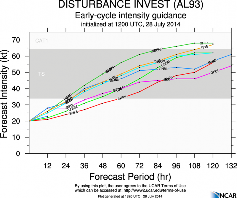
DISTURBANCE INVEST (AL932014) 20140728 1200 UTC
...00 HRS... ...12 HRS... ...24 HRS... ...36 HRS...
140728 1200 140729 0000 140729 1200 140730 0000
LAT LON LAT LON LAT LON LAT LON
BAMS 10.0N 32.5W 10.4N 35.8W 10.8N 39.2W 11.2N 42.9W
BAMD 10.0N 32.5W 10.3N 35.1W 10.5N 37.7W 10.6N 40.5W
BAMM 10.0N 32.5W 10.3N 35.2W 10.5N 37.9W 10.9N 40.9W
LBAR 10.0N 32.5W 9.9N 35.4W 9.8N 38.7W 9.8N 42.1W
SHIP 20KTS 26KTS 34KTS 42KTS
DSHP 20KTS 26KTS 34KTS 42KTS
...48 HRS... ...72 HRS... ...96 HRS... ..120 HRS...
140730 1200 140731 1200 140801 1200 140802 1200
LAT LON LAT LON LAT LON LAT LON
BAMS 11.3N 46.8W 11.9N 53.6W 12.3N 58.9W 13.8N 63.6W
BAMD 10.9N 43.2W 12.3N 48.3W 14.5N 52.5W 17.8N 56.5W
BAMM 11.4N 43.9W 12.9N 49.9W 14.7N 55.5W 17.1N 60.9W
LBAR 9.6N 45.3W 10.2N 51.0W 13.4N 55.5W 0.0N 0.0W
SHIP 49KTS 61KTS 66KTS 68KTS
DSHP 49KTS 61KTS 66KTS 68KTS
...INITIAL CONDITIONS...
LATCUR = 10.0N LONCUR = 32.5W DIRCUR = 270DEG SPDCUR = 12KT
LATM12 = 10.4N LONM12 = 30.0W DIRM12 = 263DEG SPDM12 = 12KT
LATM24 = 10.7N LONM24 = 27.6W
WNDCUR = 20KT RMAXWD = 60NM WNDM12 = 20KT
CENPRS = 1011MB OUTPRS = 1013MB OUTRAD = 120NM SDEPTH = M
RD34NE = 0NM RD34SE = 0NM RD34SW = 0NM RD34NW = 0NM
WHXX01 KWBC 281254
CHGHUR
TROPICAL CYCLONE GUIDANCE MESSAGE
NWS NATIONAL HURRICANE CENTER MIAMI FL
1254 UTC MON JUL 28 2014
DISCLAIMER...NUMERICAL MODELS ARE SUBJECT TO LARGE ERRORS.
PLEASE REFER TO NHC OFFICIAL FORECASTS FOR TROPICAL CYCLONE
AND SUBTROPICAL CYCLONE INFORMATION.
ATLANTIC OBJECTIVE AIDS FOR
DISTURBANCE INVEST (AL932014) 20140728 1200 UTC
...00 HRS... ...12 HRS... ...24 HRS... ...36 HRS...
140728 1200 140729 0000 140729 1200 140730 0000
LAT LON LAT LON LAT LON LAT LON
BAMS 10.0N 32.5W 10.4N 35.8W 10.8N 39.2W 11.2N 42.9W
BAMD 10.0N 32.5W 10.3N 35.1W 10.5N 37.7W 10.6N 40.5W
BAMM 10.0N 32.5W 10.3N 35.2W 10.5N 37.9W 10.9N 40.9W
LBAR 10.0N 32.5W 9.9N 35.4W 9.8N 38.7W 9.8N 42.1W
SHIP 20KTS 26KTS 34KTS 42KTS
DSHP 20KTS 26KTS 34KTS 42KTS
...48 HRS... ...72 HRS... ...96 HRS... ..120 HRS...
140730 1200 140731 1200 140801 1200 140802 1200
LAT LON LAT LON LAT LON LAT LON
BAMS 11.3N 46.8W 11.9N 53.6W 12.3N 58.9W 13.8N 63.6W
BAMD 10.9N 43.2W 12.3N 48.3W 14.5N 52.5W 17.8N 56.5W
BAMM 11.4N 43.9W 12.9N 49.9W 14.7N 55.5W 17.1N 60.9W
LBAR 9.6N 45.3W 10.2N 51.0W 13.4N 55.5W 0.0N 0.0W
SHIP 49KTS 61KTS 66KTS 68KTS
DSHP 49KTS 61KTS 66KTS 68KTS
...INITIAL CONDITIONS...
LATCUR = 10.0N LONCUR = 32.5W DIRCUR = 270DEG SPDCUR = 12KT
LATM12 = 10.4N LONM12 = 30.0W DIRM12 = 263DEG SPDM12 = 12KT
LATM24 = 10.7N LONM24 = 27.6W
WNDCUR = 20KT RMAXWD = 60NM WNDM12 = 20KT
CENPRS = 1011MB OUTPRS = 1013MB OUTRAD = 120NM SDEPTH = M
RD34NE = 0NM RD34SE = 0NM RD34SW = 0NM RD34NW = 0NM
0 likes
Visit the Caribbean-Central America Weather Thread where you can find at first post web cams,radars
and observations from Caribbean basin members Click Here
and observations from Caribbean basin members Click Here
-
gatorcane

- S2K Supporter
- Posts: 23708
- Age: 48
- Joined: Sun Mar 13, 2005 3:54 pm
- Location: Boca Raton, FL
We still see two different long-term steering forecasts from the global models:
ECMWF/NAVGEM - Build in a Bermuda High / ridge int 7-10 day timeframe.
GFS/CMC - Keep the Eastern North America trough hanging around through 10 days
Take a look at the 500MB flow pattern between the GFS and NAVGEM models below at 180 hours. NAVGEM show more of a ridge over the Western Atlantic that extends westwards which would recurve the system more west whereas the GFS would recurve more east. Also note position of our system as the NAVGEM is much slower at moving the system west than the GFS (NAVGEM has it near the Leewards and GFS already NW of Puerto Rico):
00Z GFS 180 hours:

00Z NAVGEM 180 hours:

Now here is the 192 hour ECMWF (since there is no 180 hour graphic on the free version). If you look closely at the light-grey dotted lines, you can see the 500MB data. You can see the Bermuda High over the Western Atlantic (dotted line circle) though as KWT pointed out, it doesn't extend as far west as previous ECMWF runs:

ECMWF/NAVGEM - Build in a Bermuda High / ridge int 7-10 day timeframe.
GFS/CMC - Keep the Eastern North America trough hanging around through 10 days
Take a look at the 500MB flow pattern between the GFS and NAVGEM models below at 180 hours. NAVGEM show more of a ridge over the Western Atlantic that extends westwards which would recurve the system more west whereas the GFS would recurve more east. Also note position of our system as the NAVGEM is much slower at moving the system west than the GFS (NAVGEM has it near the Leewards and GFS already NW of Puerto Rico):
00Z GFS 180 hours:
00Z NAVGEM 180 hours:
Now here is the 192 hour ECMWF (since there is no 180 hour graphic on the free version). If you look closely at the light-grey dotted lines, you can see the 500MB data. You can see the Bermuda High over the Western Atlantic (dotted line circle) though as KWT pointed out, it doesn't extend as far west as previous ECMWF runs:
0 likes
Re:
gatorcane wrote:We still see two different long-term steering forecasts from the global models:
ECMWF/NAVGEM - Build in a Bermuda High / ridge int 7-10 day timeframe.
GFS/CMC - Keep the Eastern North America trough hanging around through 10 days
Take a look at the 500MB flow pattern between the GFS and NAVGEM models below at 180 hours. NAVGEM show more of a ridge over the Western Atlantic that extends westwards which would recurve the system more west whereas the GFS would recurve more east. Also note position of our system as the NAVGEM is much slower at moving the system west than the GFS (NAVGEM has it near the Leewards and GFS already NW of Puerto Rico):
00Z GFS 180 hours:
http://i62.tinypic.com/2d8l4qb.jpg
00Z NAVGEM 180 hours:
http://i57.tinypic.com/14j0ykg.jpg
Now here is the 192 hour ECMWF (since there is no 180 hour graphic on the free version). If you look closely at the light-grey dotted lines, you can see the 500MB data. You can see the Bermuda High over the Western Atlantic (dotted line circle) though as KWT pointed out, it doesn't extend as far west as previous ECMWF runs:
http://i58.tinypic.com/2d6tx6h.jpg
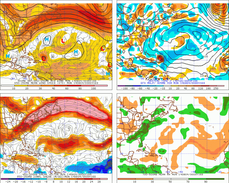
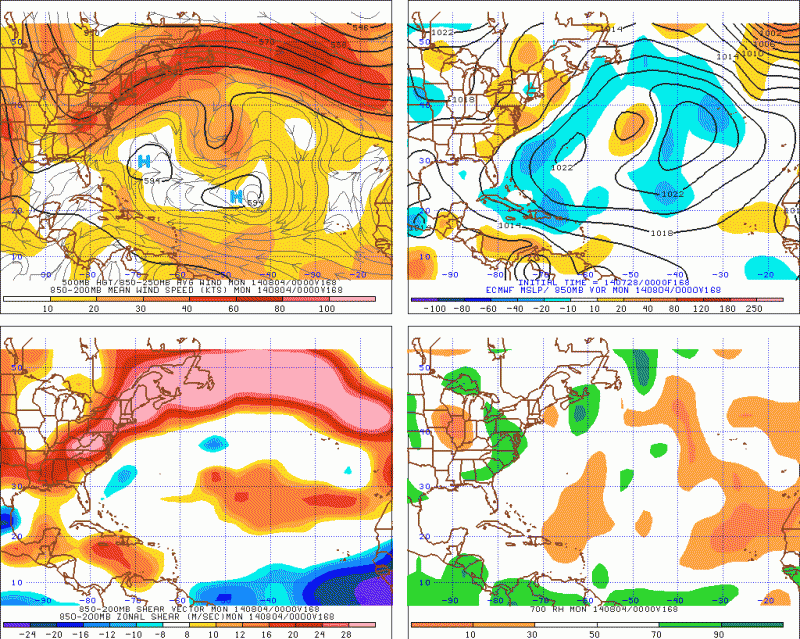
Agree, both the GFS and ECMWF have the trough positioned in the same area at 168 hrs of their forecast, with the trough's axis positive tilted from the eastern Great Lakes to the central gulf coast. The difference is the position of the building Bermuda ridge they both forecast, the GFS has is NE of Bermuda while the Euro has it SW of Bermuda.
0 likes
-
Blown Away
- S2K Supporter
- Posts: 10253
- Joined: Wed May 26, 2004 6:17 am
Re: ATL: INVEST 93L - Models

12z... Looks like a close miss to the NE Caribbean... Goes below 20/60 and through Hebert Box...
0 likes
Hurricane Eye Experience: David 79, Irene 99, Frances 04, Jeanne 04, Wilma 05… Hurricane Brush Experience: Andrew 92, Erin 95, Floyd 99, Matthew 16, Irma 17, Ian 22, Nicole 22…
Who is online
Users browsing this forum: No registered users and 36 guests