180 hours below:

Moderator: S2k Moderators

stormlover2013 wrote:Still a long ways to go, can't trust any model past 7 days!!! It has to develop first!!
KWT wrote:CMC comes close to the LA but probably just misses them.
NDG wrote:Something that I have noticed during the past 4-5 years when Bermuda has been threaten a lot by tropical systems, especially during 2010 is that the MS river valley and SE US has been dominated by ridging while the troughiness pattern has been more in the western Atlantic into New England in the 2010 season, the Bermuda ridge was for the most part absent. If you noticed this coming trough is not forecasted to sweep on through the western Atlantic which definitely would had convinced me that a recurve out to sea would be the outcome of 93L.
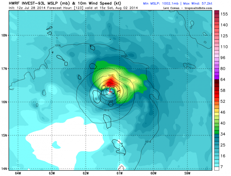
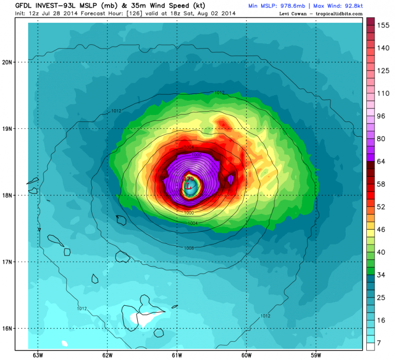
NDG wrote:12z GFDL and HWRF runs.
GFDL is crazy, lol.
http://i20.photobucket.com/albums/b245/ ... 5c0967.png
http://i20.photobucket.com/albums/b245/ ... f0e8ad.png
hurricaneCW wrote:stormlover2013 wrote:Still a long ways to go, can't trust any model past 7 days!!! It has to develop first!!
Thank you. Can we at least have an actual system before saying "oh yea this will definitely recurve at so and so". Who knows how things will be a week from now and we've seen plenty of systems forecast to recurve very early only to make it much further west and even Arthur ended of being further west than models said it would initially be.
TheStormExpert wrote:NDG wrote:12z GFDL and HWRF runs.
GFDL is crazy, lol.
http://i20.photobucket.com/albums/b245/ ... 5c0967.png
http://i20.photobucket.com/albums/b245/ ... f0e8ad.png
How did the GFDL perform with Hurricane Arthur compared to the HWRF.
NDG wrote:12z Euro is on board with developing 93L, the resolution that I am looking at is weaker than the GFS so further south and west than the GFS track.


xironman wrote:NDG wrote:12z Euro is on board with developing 93L, the resolution that I am looking at is weaker than the GFS so further south and west than the GFS track.
Actually makes it into the Caribbean, but super weak.


Users browsing this forum: No registered users and 34 guests