ATL: BERTHA - Models
Moderator: S2k Moderators
-
SFLcane

- S2K Supporter

- Posts: 10281
- Age: 48
- Joined: Sat Jun 05, 2010 1:44 pm
- Location: Lake Worth Florida
Re: ATL: INVEST 93L - Models
At this rate intensity the models are predicting this thing will miss the islands. Again just don't see much to keep on westerly course which might threaten the eastcoast. Same story line past 3-5 yrs.
0 likes
-
SouthDadeFish

- Professional-Met

- Posts: 2835
- Joined: Thu Sep 23, 2010 2:54 pm
- Location: Miami, FL
- Contact:
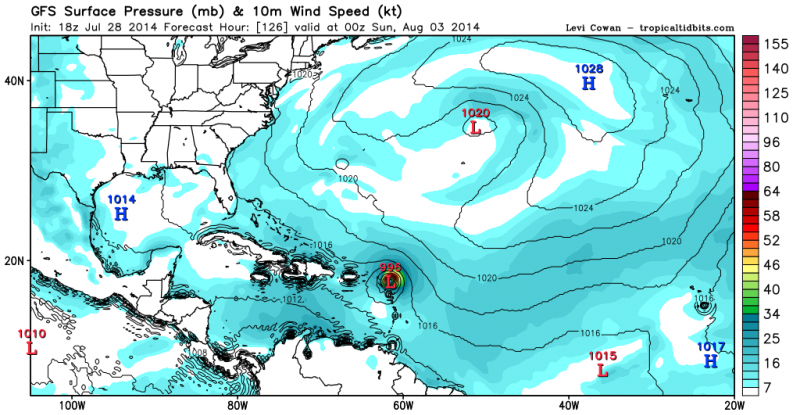
Folks, the short term upper-level pattern is very complex as depicted by the GFS. Its forecast reveals an extreme amplification of the upper-level flow (200mb) over the Northern Atlantic as ridging builds downstream of the strong trough over the Eastern coast of N.A... Consequently the cutoff low near the Azores gets spit off to the west and over the heart of the Atlantic. These solutions are notoriously difficult to forecast and depending on how much/where the mid-latitude wave train amplifies and where the resultant PV streamer goes, there will be significant ramifications in the mid-long range forecast. So in my opinion, I wouldn't put too much stock (even less than normal) into any 5+ day model forecast. Of immediate concern is the threat this system can pose to the northern Lesser Antilles.
0 likes


18Z are better tracks if they verify. That upper level low north of Puerto Rico may be replaced by another in the same general area after 36 hours which often happens. Combine that with a trough off the east coast and we could have a fish.
Current ULL looks like it is ready to drop south or dissipate though.
Current ULL looks like it is ready to drop south or dissipate though.
0 likes


-
stormlover2013
Re:
Nimbus wrote:18Z are better tracks if they verify. That upper level low north of Puerto Rico may be replaced by another in the same general area after 36 hours which often happens. Combine that with a trough off the east coast and we could have a fish.
Current ULL looks like it is ready to drop south or dissipate though.
Still a long say to go!!
0 likes
-
TheStormExpert
Re: Re:
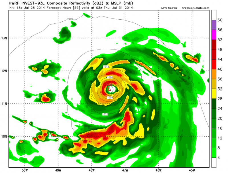
RL3AO wrote:gatorcane wrote:12Z GFS 180 hour shear chart. We can see 93L moving NW east of the Bahamas but it seems the GFS is really bring down the shear in the Caribbean starting around 1 week from now and by 240 hours conditions look favorable across the Caribbean.
Noticed that yesterday. Something worth watching as we enter August.
Look at all that shear though off the west coast of Africa.
0 likes


Re: ATL: INVEST 93L - Models
Seems to me like the NHC is leaning toward the Euro a little otherwise we would not see so much of that bubble in the Carribean.

0 likes
The following post is NOT an official forecast and should not be used as such. It is just the opinion of the poster and may or may not be backed by sound meteorological data. It is NOT endorsed by any professional institution including storm2k.org For Official Information please refer to the NHC and NWS products.

-
cycloneye

- Admin

- Posts: 149505
- Age: 69
- Joined: Thu Oct 10, 2002 10:54 am
- Location: San Juan, Puerto Rico
Re: ATL: INVEST 93L - Models
WHXX01 KWBC 290041
CHGHUR
TROPICAL CYCLONE GUIDANCE MESSAGE
NWS NATIONAL HURRICANE CENTER MIAMI FL
0041 UTC TUE JUL 29 2014
DISCLAIMER...NUMERICAL MODELS ARE SUBJECT TO LARGE ERRORS.
PLEASE REFER TO NHC OFFICIAL FORECASTS FOR TROPICAL CYCLONE
AND SUBTROPICAL CYCLONE INFORMATION.
ATLANTIC OBJECTIVE AIDS FOR
DISTURBANCE INVEST (AL932014) 20140729 0000 UTC
...00 HRS... ...12 HRS... ...24 HRS... ...36 HRS...
140729 0000 140729 1200 140730 0000 140730 1200
LAT LON LAT LON LAT LON LAT LON
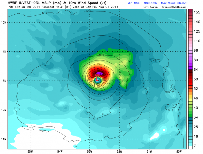
BAMS 9.6N 35.4W 9.9N 38.4W 10.3N 41.8W 10.3N 45.2W
BAMD 9.6N 35.4W 9.8N 37.8W 10.0N 40.2W 10.3N 42.6W
BAMM 9.6N 35.4W 9.9N 37.8W 10.3N 40.3W 10.7N 42.9W
LBAR 9.6N 35.4W 9.4N 38.3W 9.4N 41.7W 9.4N 44.9W
SHIP 25KTS 36KTS 46KTS 54KTS
DSHP 25KTS 36KTS 46KTS 54KTS
...48 HRS... ...72 HRS... ...96 HRS... ..120 HRS...
140731 0000 140801 0000 140802 0000 140803 0000
LAT LON LAT LON LAT LON LAT LON
BAMS 10.4N 48.4W 10.6N 53.6W 11.3N 57.8W 14.2N 62.1W
BAMD 10.7N 44.9W 12.2N 49.3W 14.8N 53.7W 18.1N 58.4W
BAMM 11.3N 45.5W 12.8N 50.7W 15.2N 56.0W 18.2N 61.4W
LBAR 9.5N 48.0W 9.8N 53.3W 10.9N 57.2W 11.2N 61.1W
SHIP 62KTS 76KTS 80KTS 82KTS
DSHP 62KTS 76KTS 80KTS 82KTS
...INITIAL CONDITIONS...
LATCUR = 9.6N LONCUR = 35.4W DIRCUR = 270DEG SPDCUR = 13KT
LATM12 = 9.8N LONM12 = 32.5W DIRM12 = 270DEG SPDM12 = 12KT
LATM24 = 9.9N LONM24 = 30.0W
WNDCUR = 25KT RMAXWD = 30NM WNDM12 = 20KT
CENPRS = 1010MB OUTPRS = 1012MB OUTRAD = 100NM SDEPTH = M
RD34NE = 0NM RD34SE = 0NM RD34SW = 0NM RD34NW = 0NM
$$
CHGHUR
TROPICAL CYCLONE GUIDANCE MESSAGE
NWS NATIONAL HURRICANE CENTER MIAMI FL
0041 UTC TUE JUL 29 2014
DISCLAIMER...NUMERICAL MODELS ARE SUBJECT TO LARGE ERRORS.
PLEASE REFER TO NHC OFFICIAL FORECASTS FOR TROPICAL CYCLONE
AND SUBTROPICAL CYCLONE INFORMATION.
ATLANTIC OBJECTIVE AIDS FOR
DISTURBANCE INVEST (AL932014) 20140729 0000 UTC
...00 HRS... ...12 HRS... ...24 HRS... ...36 HRS...
140729 0000 140729 1200 140730 0000 140730 1200
LAT LON LAT LON LAT LON LAT LON
BAMS 9.6N 35.4W 9.9N 38.4W 10.3N 41.8W 10.3N 45.2W
BAMD 9.6N 35.4W 9.8N 37.8W 10.0N 40.2W 10.3N 42.6W
BAMM 9.6N 35.4W 9.9N 37.8W 10.3N 40.3W 10.7N 42.9W
LBAR 9.6N 35.4W 9.4N 38.3W 9.4N 41.7W 9.4N 44.9W
SHIP 25KTS 36KTS 46KTS 54KTS
DSHP 25KTS 36KTS 46KTS 54KTS
...48 HRS... ...72 HRS... ...96 HRS... ..120 HRS...
140731 0000 140801 0000 140802 0000 140803 0000
LAT LON LAT LON LAT LON LAT LON
BAMS 10.4N 48.4W 10.6N 53.6W 11.3N 57.8W 14.2N 62.1W
BAMD 10.7N 44.9W 12.2N 49.3W 14.8N 53.7W 18.1N 58.4W
BAMM 11.3N 45.5W 12.8N 50.7W 15.2N 56.0W 18.2N 61.4W
LBAR 9.5N 48.0W 9.8N 53.3W 10.9N 57.2W 11.2N 61.1W
SHIP 62KTS 76KTS 80KTS 82KTS
DSHP 62KTS 76KTS 80KTS 82KTS
...INITIAL CONDITIONS...
LATCUR = 9.6N LONCUR = 35.4W DIRCUR = 270DEG SPDCUR = 13KT
LATM12 = 9.8N LONM12 = 32.5W DIRM12 = 270DEG SPDM12 = 12KT
LATM24 = 9.9N LONM24 = 30.0W
WNDCUR = 25KT RMAXWD = 30NM WNDM12 = 20KT
CENPRS = 1010MB OUTPRS = 1012MB OUTRAD = 100NM SDEPTH = M
RD34NE = 0NM RD34SE = 0NM RD34SW = 0NM RD34NW = 0NM
$$
0 likes
Visit the Caribbean-Central America Weather Thread where you can find at first post web cams,radars
and observations from Caribbean basin members Click Here
and observations from Caribbean basin members Click Here
-
cycloneye
- Admin
- Posts: 149505
- Age: 69
- Joined: Thu Oct 10, 2002 10:54 am
- Location: San Juan, Puerto Rico
Re: ATL: INVEST 93L - Models
The center at 00z is south of the models.

0 likes
Visit the Caribbean-Central America Weather Thread where you can find at first post web cams,radars
and observations from Caribbean basin members Click Here
and observations from Caribbean basin members Click Here
-
cycloneye
- Admin
- Posts: 149505
- Age: 69
- Joined: Thu Oct 10, 2002 10:54 am
- Location: San Juan, Puerto Rico
Re: ATL: INVEST 93L - Models

0 likes
Visit the Caribbean-Central America Weather Thread where you can find at first post web cams,radars
and observations from Caribbean basin members Click Here
and observations from Caribbean basin members Click Here
-
Blown Away

- S2K Supporter
- Posts: 10253
- Joined: Wed May 26, 2004 6:17 am
Re: ATL: INVEST 93L - Models
0 likes
Hurricane Eye Experience: David 79, Irene 99, Frances 04, Jeanne 04, Wilma 05… Hurricane Brush Experience: Andrew 92, Erin 95, Floyd 99, Matthew 16, Irma 17, Ian 22, Nicole 22…

-
TheStormExpert
Re: ATL: INVEST 93L - Models
Blown Away wrote::uarrow:The NHC likes the TVCN, I wonder if that west bend means anything???
Probably just bending to make a good consensus of all the models shown.
0 likes
-
djones65
- Category 1

- Posts: 264
- Age: 60
- Joined: Mon Jun 20, 2005 12:05 am
- Location: Ocean Springs, MS
I agree with Blown Away that the sharp bend to the west may be quite significant. Remember TVCN is the NHC 's "blend" or "average" of what thy consider most reliable models. They always trend close to TVCN with their official forecasts. So perhaps they expect significant weakening and a bend back to west with shallow layer steering? Or who knows? Perhaps the SW Atlantic ridge builds significantly to delay any recurve???
Always NEVER trust my thoughts and/or opinions. ALWAYS rely on NHC and the local NWS office advices!
Always NEVER trust my thoughts and/or opinions. ALWAYS rely on NHC and the local NWS office advices!
0 likes

Who is online
Users browsing this forum: No registered users and 26 guests