TROPICAL WEATHER DISCUSSION
NWS NATIONAL HURRICANE CENTER MIAMI FL
805 PM EDT MON JUL 28 2014
...SPECIAL FEATURE...
A 1011 MB LOW IS CENTERED ON THE MONSOON TROUGH NEAR 10N34W. A
TROPICAL WAVE IS W OF THE LOW AND EXTENDS FROM 18N40W TO 9N39W.
THE LOW AND TROPICAL WAVE ARE MOVING W AT 10-15 KT. A DEEP LAYER
MOIST ENVIRONMENT IS SUPPORTING SCATTERED MODERATE CONVECTION
FROM 6N-13N BETWEEN 30W-41W. A DRY SAHARAN AIR LAYER IS N AND W
OF THE TROPICAL WAVE. THERE IS A MEDIUM CHANCE OF FURTHER
DEVELOPMENT OF THIS WAVE WITHIN 48 HOURS. SEE THE LATEST NHC
TROPICAL WEATHER OUTLOOK UNDER AWIPS/WMO HEADERS MIATWOAT/ABNT20
KNHC FOR MORE DETAILS.
ATL: BERTHA - Post-Tropical - Discussion
Moderator: S2k Moderators

This system could puff along another day or more until it climbs out of the ITCZ.
As WXman57 explained the models seem to be keying on when it spins up.
Weak and West there is even a slight chance it could track south of Florida.
Brent crude is currently 107.525 up 0.125 (0.12%) not necessarily weather related.
This far out there is at least a 90% chance of it missing any specific State along the US Coastline.
0 likes
-
Gustywind

- Category 5

- Posts: 12334
- Joined: Mon Sep 03, 2007 7:29 am
- Location: Baie-Mahault, GUADELOUPE
From the Weather Channel
 http://www.weather.com/news/tropical-up ... n-20140513
Stu Ostro, Michael Lowry, Dr. Greg Postel Published: Jul 28, 2014, 7:25 PM EDT weather.com
- Disturbance in tropical Atlantic trying to develop, with limited success so far
ATLANTIC BASIN
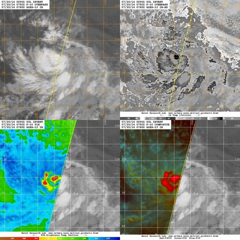
The system which came off Africa a few days ago and has been designated as Invest 93L continues moving across the tropical Atlantic quite far south, with thunderstorms persisting and coalescing. So far the bark on satellite imagery is louder than the bite, as while there is some spin evident, the nature of that and other analyses suggests it doesn't yet have a well-defined enough center of circulation for it to be a tropical depression.
Atmospheric conditions are currently neither very conducive nor very unconducive to development. Upper-level winds are a bit brisk out of the east, though not necessarily prohibitively so; the northeastern part of the tropical wave is feeling some very dry air whereas the rest of the wave is moist.
The system will have a window during the next couple of days where/when it has a chance of further developing, as conditions remain somewhat favorable for that or perhaps become a bit more so than currently; models differ in how much/quickly the Bertha wannabe will respond and spin up.
Farther out in time, at the end of the week when it's near the Lesser Antilles, there are significant differences in model forecasts in regard to how much upper-level wind hostility there'll be, vs. the ability of the system to fend that off.
Any speculation about the longer range beyond that is dependent upon these questions in the short-to-medium range being resolved.
For now, a system for folks in the eastern Caribbean islands to closely monitor for the possibility of effects by the end of the week.
Stu Ostro, Michael Lowry, Dr. Greg Postel Published: Jul 28, 2014, 7:25 PM EDT weather.com
- Disturbance in tropical Atlantic trying to develop, with limited success so far
ATLANTIC BASIN
The system which came off Africa a few days ago and has been designated as Invest 93L continues moving across the tropical Atlantic quite far south, with thunderstorms persisting and coalescing. So far the bark on satellite imagery is louder than the bite, as while there is some spin evident, the nature of that and other analyses suggests it doesn't yet have a well-defined enough center of circulation for it to be a tropical depression.
Atmospheric conditions are currently neither very conducive nor very unconducive to development. Upper-level winds are a bit brisk out of the east, though not necessarily prohibitively so; the northeastern part of the tropical wave is feeling some very dry air whereas the rest of the wave is moist.
The system will have a window during the next couple of days where/when it has a chance of further developing, as conditions remain somewhat favorable for that or perhaps become a bit more so than currently; models differ in how much/quickly the Bertha wannabe will respond and spin up.
Farther out in time, at the end of the week when it's near the Lesser Antilles, there are significant differences in model forecasts in regard to how much upper-level wind hostility there'll be, vs. the ability of the system to fend that off.
Any speculation about the longer range beyond that is dependent upon these questions in the short-to-medium range being resolved.
For now, a system for folks in the eastern Caribbean islands to closely monitor for the possibility of effects by the end of the week.
0 likes
-
Aric Dunn
- Category 5
- Posts: 21238
- Age: 43
- Joined: Sun Sep 19, 2004 9:58 pm
- Location: Ready for the Chase.
- Contact:
Re:
SouthDadeFish wrote:Pretty silly in my opinion for John to call this a non-threat to FL... it is not even a classified system yet. While it is true a FL landfall looks unlikely at this time, totally dismissing it as a threat doesn't seem wise with a system so far out... Anyway, I am quite surprised NHC only went with 50% at the 8 pm update. I think chances are likely this will be a classified system tomorrow after seeing recent trends.
Agreed .. however NHC has to go with a statistical development each and every time .. then when something deviates from that.. it becomes a anomaly and future forecast can be better adjusted..
0 likes
Note: If I make a post that is brief. Please refer back to previous posts for the analysis or reasoning. I do not re-write/qoute what my initial post said each time.
If there is nothing before... then just ask
Space & Atmospheric Physicist, Embry-Riddle Aeronautical University,
I believe the sky is falling...
If there is nothing before... then just ask
Space & Atmospheric Physicist, Embry-Riddle Aeronautical University,
I believe the sky is falling...
-
stormlover2013
Re: ATL: INVEST 93L - Discussion
Lol it has a real good shot going towards florida, just dumb to make a statement like that
0 likes

Very evident banding is starting to take shape on the southern end now, near the center, and if you watch closely you can see inflow storms moving towards the small CDO-like feature.
0 likes
The above post is not official and should not be used as such. It is the opinion of the poster and may or may not be backed by sound meteorological data. It is not endorsed by any professional institution or storm2k.org. For official information, please refer to the NHC and NWS products.

Re: ATL: INVEST 93L - Discussion
Ascat Pass

0 likes
The following post is NOT an official forecast and should not be used as such. It is just the opinion of the poster and may or may not be backed by sound meteorological data. It is NOT endorsed by any professional institution including storm2k.org For Official Information please refer to the NHC and NWS products.
-
Miami Storm Tracker

- Category 4

- Posts: 916
- Age: 68
- Joined: Sun Jun 13, 2010 10:12 pm
- Location: Key Largo, Fla.
- Contact:
Re:
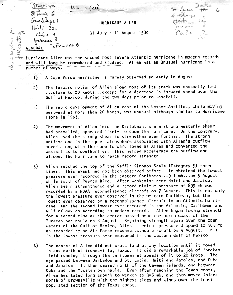
Alyono wrote:read bullet point 4
If this becomes intense east of the Caribbean, it will be a similar setup to Allen
http://www.nhc.noaa.gov/archive/storm_w ... elim01.gif
Great article Alyono not saying it will be a repeat but it just goes to show, it is possible.
0 likes
-
Evil Jeremy

- S2K Supporter

- Posts: 5463
- Age: 32
- Joined: Mon Apr 10, 2006 2:10 pm
- Location: Los Angeles, CA
Re: ATL: INVEST 93L - Discussion
stormlover2013 wrote:Lol it has a real good shot going towards florida, just dumb to make a statement like that
A statement like this is just as bad as saying it won't go to Florida at all.
Can we just ban the F word until this system is in the Caribbean? Seriously, to early to say where this system will end up.
hookemfins wrote:RL3AO wrote:djones65 wrote:So Morales is an "on-air" meteorologist or personality?
John Morales is a fantastic meteorologist in South Florida.
I've heard Morales say it wasn't going to rain in a certain location while it was raining. I hear him quite often say irresponsible and stupid stuff. So I am not surprised Morales said that Florida would not be affected by 93L. smh
No one's perfect. Morales was the former head of NWS Miami and is a fantastic meteorologist.
Lets all just calm down a bit.
Last edited by Evil Jeremy on Mon Jul 28, 2014 10:43 pm, edited 1 time in total.
0 likes
Frances 04 / Jeanne 04 / Katrina 05 / Wilma 05 / Fay 08 / Debby 12 / Andrea 13 / Colin 16 / Hermine 16 / Matthew 16 / Irma 17
I personally think it's somewhat irresponsible for anyone on television to give any impression of certainty of where something will or will not go this far out.
0 likes
The above post is not official and should not be used as such. It is the opinion of the poster and may or may not be backed by sound meteorological data. It is not endorsed by any professional institution or storm2k.org. For official information, please refer to the NHC and NWS products.
-
cycloneye

- Admin

- Posts: 149550
- Age: 69
- Joined: Thu Oct 10, 2002 10:54 am
- Location: San Juan, Puerto Rico
Re: ATL: INVEST 93L - Discussion
Let's get back to the topic on hand and that is Invest 93L,thanks.
0 likes
Visit the Caribbean-Central America Weather Thread where you can find at first post web cams,radars
and observations from Caribbean basin members Click Here
and observations from Caribbean basin members Click Here
-
Hurricane Alexis

- Category 2

- Posts: 683
- Age: 29
- Joined: Thu Jun 14, 2012 7:59 pm
- Location: Miami,Florida
Re: ATL: INVEST 93L - Discussion
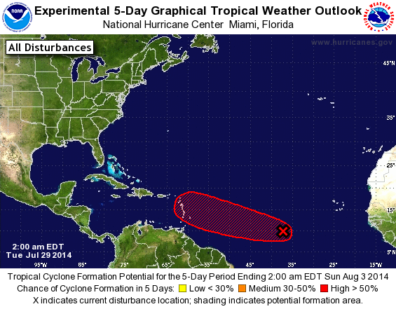
Code red for 48 hour forecast.
1. Satellite data indicate that an area of low pressure located about
1000 miles west-southwest of the Cape Verde Islands is becoming
better defined. The associated shower and thunderstorm activity
continues to gradually organize, and a tropical depression could
form during the next day or so while the system moves westward or
west-northwestward at 10 to 15 mph.
* Formation chance through 48 hours...high...70 percent.
* Formation chance through 5 days...high...80 percent.
5-day graphic

0 likes
Personal Forecast Disclaimer:
The posts in this forum are NOT official forecast and should not be used as such. They are just the opinion of the poster and may or may not be backed by sound meteorological data. They are NOT endorsed by any professional institution or storm2k.org. For official information, please refer to the NHC and NWS products.
The posts in this forum are NOT official forecast and should not be used as such. They are just the opinion of the poster and may or may not be backed by sound meteorological data. They are NOT endorsed by any professional institution or storm2k.org. For official information, please refer to the NHC and NWS products.

-
Aric Dunn
- Category 5
- Posts: 21238
- Age: 43
- Joined: Sun Sep 19, 2004 9:58 pm
- Location: Ready for the Chase.
- Contact:
Re:
Alyono wrote:seeing signs of very strong easterly shear over this. May not see development until the shear drops off late tomorrow
yeah pretty much exactly the time frame that the shear ( though limited ) was forecast to drop off. its far out there and the NHC is not likely to jump on it till after its already a TD.. fairly normal procedure. follow guidelines until things force a change ..
0 likes
Note: If I make a post that is brief. Please refer back to previous posts for the analysis or reasoning. I do not re-write/qoute what my initial post said each time.
If there is nothing before... then just ask
Space & Atmospheric Physicist, Embry-Riddle Aeronautical University,
I believe the sky is falling...
If there is nothing before... then just ask
Space & Atmospheric Physicist, Embry-Riddle Aeronautical University,
I believe the sky is falling...

-
Gustywind
- Category 5
- Posts: 12334
- Joined: Mon Sep 03, 2007 7:29 am
- Location: Baie-Mahault, GUADELOUPE
From Accuweather.com
http://www.accuweather.com/en/weather-v ... 62Tropical
Depression May Form in the Atlantic
July 29, 2014; 5:52 AM
An area of disturbed weather in the Central Atlantic could slowly organize and impact the Leeward Islands by Saturday.
Depression May Form in the Atlantic
July 29, 2014; 5:52 AM
An area of disturbed weather in the Central Atlantic could slowly organize and impact the Leeward Islands by Saturday.
0 likes
-
Gustywind
- Category 5
- Posts: 12334
- Joined: Mon Sep 03, 2007 7:29 am
- Location: Baie-Mahault, GUADELOUPE
TROPICAL WEATHER DISCUSSION
NWS NATIONAL HURRICANE CENTER MIAMI FL
205 AM EDT TUE JUL 29 2014
...SPECIAL FEATURE...
A DISTURBANCE OVER THE CENTRAL TROPICAL ATLANTIC HAS BECOME
BETTER ORGANIZED DURING THE PAST SEVERAL HOURS. THE SYSTEM IS
ASSOCIATED WITH A 1010 MB LOW EMBEDDED IN THE MONSOON TROUGH
NEAR 9N35W. RAINBANDS OF SCATTERED MODERATE CONVECTION ARE FROM
5N-14N BETWEEN 31W-42W. THERE IS A MEDIUM CHANCE OF FURTHER
DEVELOPMENT OF THIS DISTURBANCE WITHIN 48 HOURS. SEE THE LATEST
NHC TROPICAL WEATHER OUTLOOK UNDER AWIPS/WMO HEADERS
MIATWOAT/ABNT20 KNHC FOR MORE DETAILS.
0 likes
-
TropicalAnalystwx13

- Category 5
- Posts: 2109
- Age: 28
- Joined: Tue Jul 19, 2011 8:20 pm
- Location: Wilmington, NC
- Contact:

Who is online
Users browsing this forum: No registered users and 14 guests