ATL: BERTHA - Post-Tropical - Discussion

Moderator: S2k Moderators

Message
Author
User avatar
TropicalAnalystwx13
Category 5
Category 5
Posts: 2109
Age: 27
Joined: Tue Jul 19, 2011 8:20 pm
Location: Wilmington, NC
Contact:

Re:

#241 Postby TropicalAnalystwx13 » Tue Jul 29, 2014 11:31 am

TheStormExpert wrote:What ever happened to the MJO, is it forecasted to appear next week still or will it remain nonexistent like it has all season so far?

It's still in the central and eastern Pacific. It should head east, but as an increasingly incoherent feature.

cycloneye wrote:Any new Kelvin Wave coming to help it?

Doesn't look like it.
Last edited by TropicalAnalystwx13 on Tue Jul 29, 2014 11:36 am, edited 3 times in total.
0 likes   

User avatar
StarmanHDB
Tropical Storm
Tropical Storm
Posts: 201
Age: 60
Joined: Wed Sep 02, 2009 7:59 pm
Location: West Palm Beach, Florida

Re: ATL: INVEST 93L - Discussion

#242 Postby StarmanHDB » Tue Jul 29, 2014 11:32 am

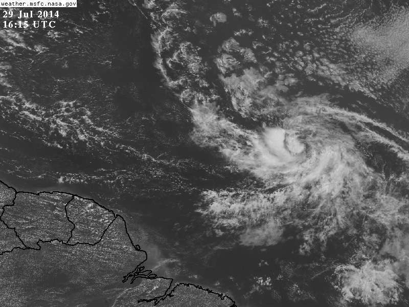
Alyono wrote:just stop! There is NOTHING that has yet to prove a well defined LLC. It's becoming better defined, but now the convection is dropping off. Notice all the mets are saying this has yet to form? That should tell you something


To the Pro Mets in this forum, THANK YOU for trying to provide reason! I know that reading the endless posts of the "Hurricane Wishers and Dreamers" must drive you batty, but please note that I while I regard many posts in these forums as mere fluff, I ALWAYS read all Pro Met posts with keen interest simply because I know that you all know your stuff. Once again, thank you!

As for 93L, I hope that when it does develop it provides much needed rain for the good folks in the Caribbean (without destruction, of course).

Welcome to the Wave Train, 2014 Style!

:flag:
0 likes   

User avatar
TheAustinMan
Category 5
Category 5
Posts: 1046
Age: 25
Joined: Mon Jul 08, 2013 4:26 pm
Location: United States
Contact:

Re: Re:

#243 Postby TheAustinMan » Tue Jul 29, 2014 11:37 am

cycloneye wrote:
TropicalAnalystwx13 wrote:My forecast has this becoming a tropical depression by tomorrow night (It should already be designated, but I'll move on...) and a tropical storm on the day Thursday as wind shear lessens significantly. I could see this being a 50-60 mph tropical storm as it approaches the northern Leeward Islands over the weekend. After that time, the trough over the East Coast should be able to turn this more poleward, and I see a recurvature west of Bermuda as an intensifying hurricane.


Any new Kelvin Wave coming to help it?


The one last night is passing by, nothing imminent in terms of Kelvin waves for a bit after that. NOTE: DATED PHOTO
Image
0 likes   
ImageImageImage
Treat my opinions with a grain of salt. For official information see your local weather service.

User avatar
SouthDadeFish
Professional-Met
Professional-Met
Posts: 2835
Joined: Thu Sep 23, 2010 2:54 pm
Location: Miami, FL
Contact:

#244 Postby SouthDadeFish » Tue Jul 29, 2014 11:39 am

Low-level rotation is perhaps stronger than its ever been. All that appears to be lacking is organized and persistent convection. One convective burst could make the difference.
0 likes   

Frank2
Category 5
Category 5
Posts: 4061
Joined: Mon Jul 25, 2005 12:47 pm

Re: ATL: INVEST 93L - Discussion

#245 Postby Frank2 » Tue Jul 29, 2014 11:41 am

I agree - having the pro mets here helps keep the discussion on the practical. I was a tech during my weather days (plotting maps, etc.) and will never say that I know what the professionals know (and the meteorologists I know personally will agree with a smile), but it's good to have the support of the professionals here...

P.S. A KW is like a wave at the beach - it comes, it lifts you up as it passes, and then waters become calm once again...

Frank
0 likes   

User avatar
NDG
S2K Supporter
S2K Supporter
Posts: 15446
Joined: Sun Jul 09, 2006 10:14 pm
Location: Orlando, FL

Re:

#246 Postby NDG » Tue Jul 29, 2014 11:45 am

SouthDadeFish wrote:Low-level rotation is perhaps stronger than its ever been. All that appears to be lacking is organized and persistent convection. One convective burst could make the difference.


I am glad to see a promet see what I see :D

Image
0 likes   

User avatar
gatorcane
S2K Supporter
S2K Supporter
Posts: 23689
Age: 47
Joined: Sun Mar 13, 2005 3:54 pm
Location: Boca Raton, FL

#247 Postby gatorcane » Tue Jul 29, 2014 11:55 am

Saved floater vis loop shows dry air and some easterly shear but the overall structure looks good. No sign of it gaining latitude yet:

Image
0 likes   

User avatar
KWT
Category 5
Category 5
Posts: 31415
Joined: Tue Aug 17, 2004 11:02 am
Location: UK!!!

#248 Postby KWT » Tue Jul 29, 2014 12:00 pm

Nice circulation on the system, I think that on its own will get it over the line at some point in the near future.

With that being said, the convection seems to be suffering a little, and if that is the case when the system is still attached to the ITCZ, no wonder some models make it struggle once it lifts out from those fertile grounds.

Also think its going to get further west than some of the models are expecting as well.

Lots of SAL still evident to the north.
0 likes   
Personal Forecast Disclaimer:
The posts in this forum are NOT official forecast and should not be used as such. They are just the opinion of the poster and may or may not be backed by sound meteorological data. They are NOT endorsed by any professional institution or storm2k.org. For official information, please refer to the NHC and NWS products

Alyono
Professional-Met
Professional-Met
Posts: 6961
Joined: Fri Apr 26, 2013 3:52 pm
Location: Texas Coast

#249 Postby Alyono » Tue Jul 29, 2014 12:06 pm

check ur PMs, KWT... not sure who you were trying to address in your post, but you most certainly dont have my name right
0 likes   

User avatar
NDG
S2K Supporter
S2K Supporter
Posts: 15446
Joined: Sun Jul 09, 2006 10:14 pm
Location: Orlando, FL

#250 Postby NDG » Tue Jul 29, 2014 12:07 pm

Image
0 likes   

User avatar
KWT
Category 5
Category 5
Posts: 31415
Joined: Tue Aug 17, 2004 11:02 am
Location: UK!!!

#251 Postby KWT » Tue Jul 29, 2014 12:12 pm

Dry air working well into the circulation, though as long as its near the ITCZ it should have enough moisture to still work with.
0 likes   
Personal Forecast Disclaimer:
The posts in this forum are NOT official forecast and should not be used as such. They are just the opinion of the poster and may or may not be backed by sound meteorological data. They are NOT endorsed by any professional institution or storm2k.org. For official information, please refer to the NHC and NWS products

AEWspotter
Professional-Met
Professional-Met
Posts: 57
Joined: Wed Aug 08, 2012 9:41 am

#252 Postby AEWspotter » Tue Jul 29, 2014 12:18 pm

As a Pro Met, I'll echo the sentiment of NDG and SouthDadeFish that this thing only lacks some organized & persistent convection. LLC is looking great.
0 likes   

User avatar
northjaxpro
S2K Supporter
S2K Supporter
Posts: 8900
Joined: Mon Sep 27, 2010 11:21 am
Location: Jacksonville, FL

Re: ATL: INVEST 93L - Discussion

#253 Postby northjaxpro » Tue Jul 29, 2014 12:23 pm

Frank2 wrote:I agree - having the pro mets here helps keep the discussion on the practical. I was a tech during my weather days (plotting maps, etc.) and will never say that I know what the professionals know (and the meteorologists I know personally will agree with a smile), but it's good to have the support of the professionals here...

P.S. A KW is like a wave at the beach - it comes, it lifts you up as it passes, and then waters become calm once again...

Frank

I agree. Having several pro mets on here providing their thoughts and insights to everyone else on here is the best aspect of Storm2K. I appecrite them being on here and just wanted to echo my sentiment as well.

Back on topic with 93L...
0 likes   
NEVER, EVER SAY NEVER in the tropics and weather in general, and most importantly, with life itself!!

________________________________________________________________________________________

Fay 2008 Beryl 2012 Debby 2012 Colin 2016 Hermine 2016 Julia 2016 Matthew 2016 Irma 2017 Dorian 2019

User avatar
TropicalAnalystwx13
Category 5
Category 5
Posts: 2109
Age: 27
Joined: Tue Jul 19, 2011 8:20 pm
Location: Wilmington, NC
Contact:

#254 Postby TropicalAnalystwx13 » Tue Jul 29, 2014 12:30 pm

How well 93L performs on its way to the islands will determine its long-term track and intensity. Strong northeasterly shear is plaguing the storm now, allowing for dry air entrainment. However, the SHIPS forecasts this to dramatically lessen over the next day, which should allow for intensification. As long as this is producing active convection as it enters the islands, the resultant outflow should be able to split the upper-level trough north of the islands, creating a very favorable environment for intensification (like yesterday's runs of the GFS showed). Today's 12z solution offers up that this doesn't happen, and instead the storm is sheared to death. I'm not ready to jump on that bandwagon considering that this is already a well-formed disturbance very close to officially becoming a tropical depression.
0 likes   

Rail Dawg
S2K Supporter
S2K Supporter
Posts: 326
Joined: Mon Aug 27, 2012 5:02 pm
Location: Where the eye makes landfall.

Re:

#255 Postby Rail Dawg » Tue Jul 29, 2014 12:33 pm

gatorcane wrote:Saved floater vis loop shows dry air and some easterly shear but the overall structure looks good. No sign of it gaining latitude yet:

Image


That vis loop is showing a lot. My guess is a depression here shortly as this system is in very fertile grounds.
0 likes   
Although I have been a hurricane forecaster since 1980 that only means I've been wrong lots of times.

User avatar
cycloneye
Admin
Admin
Posts: 143871
Age: 68
Joined: Thu Oct 10, 2002 10:54 am
Location: San Juan, Puerto Rico

Re: ATL: INVEST 93L - Discussion

#256 Postby cycloneye » Tue Jul 29, 2014 12:39 pm

TROPICAL WEATHER OUTLOOK
NWS NATIONAL HURRICANE CENTER MIAMI FL
200 PM EDT TUE JUL 29 2014

For the North Atlantic...Caribbean Sea and the Gulf of Mexico:

Satellite images indicate that showers and thunderstorms associated
with an area of low pressure located about 1450 miles east of the
southern Windward Islands are currently limited. This system
remains well organized, however, and it could develop into a
tropical depression later today or tomorrow while it moves westward
or west-northwestward near 15 mph.
* Formation chance through 48 hours...high...70 percent.
* Formation chance through 5 days...high...80 percent.

$$
Forecaster Pasch
0 likes   
Visit the Caribbean-Central America Weather Thread where you can find at first post web cams,radars
and observations from Caribbean basin members Click Here

Dean4Storms
S2K Supporter
S2K Supporter
Posts: 6358
Age: 62
Joined: Sun Aug 31, 2003 1:01 pm
Location: Miramar Bch. FL

#257 Postby Dean4Storms » Tue Jul 29, 2014 12:40 pm

Looks like an LLC is there and if the convection fires there is no way NHC won't hold back on pulling the trigger.
0 likes   

User avatar
cycloneye
Admin
Admin
Posts: 143871
Age: 68
Joined: Thu Oct 10, 2002 10:54 am
Location: San Juan, Puerto Rico

Re: ATL: INVEST 93L - Discussion

#258 Postby cycloneye » Tue Jul 29, 2014 1:04 pm

2 PM TWD:

...SPECIAL FEATURE...

A DISTURBANCE OVER THE CENTRAL TROPICAL ATLANTIC HAS BECOME
BETTER ORGANIZED DURING THE PAST 24 HOURS. THE SYSTEM IS
ASSOCIATED WITH A 1011 MB LOW EMBEDDED IN THE MONSOON TROUGH
NEAR 10N39W AND IS MOVING WNW 10-15 KT. A CLUSTER OF MODERATE TO
STRONG CONVECTION IS LOCATED FROM 08N-11N BETWEEN 38W-43W.
BANDING FEATURES SURROUND THE CENTER EXCEPT OVER THE NE
QUADRANT. THERE IS A HIGH CHANCE OF FURTHER DEVELOPMENT OF THIS
DISTURBANCE INTO A TROPICAL CYCLONE WITHIN THE NEXT 48 HOURS.
SEE THE LATEST NHC TROPICAL WEATHER OUTLOOK UNDER AWIPS/WMO
HEADERS MIATWOAT/ABNT20 KNHC FOR MORE DETAILS.
0 likes   
Visit the Caribbean-Central America Weather Thread where you can find at first post web cams,radars
and observations from Caribbean basin members Click Here

User avatar
Blown Away
S2K Supporter
S2K Supporter
Posts: 10140
Joined: Wed May 26, 2004 6:17 am

Re: ATL: INVEST 93L - Discussion

#259 Postby Blown Away » Tue Jul 29, 2014 1:16 pm

Image
NWS has this low still at low latitude in 72 hours... Serious NW movement needed to avoid islands from that point... IDK??
0 likes   
Hurricane Eye Experience: David 79, Irene 99, Frances 04, Jeanne 04, Wilma 05... EYE COMING MY WAY IN 2024…
Hurricane Brush Experience: Andrew 92, Erin 95, Floyd 99, Matthew 16, Irma 17, Ian 22, Nicole 22…

User avatar
HurricaneMaster_PR
Category 2
Category 2
Posts: 795
Joined: Tue Jul 22, 2003 6:23 pm
Location: San Juan, Puerto Rico

Re: ATL: INVEST 93L - Discussion

#260 Postby HurricaneMaster_PR » Tue Jul 29, 2014 1:20 pm

Weaker per SSD

DATE/TIME LAT LON CLASSIFICATION STORM
29/1745 UTC 9.5N 40.1W T1.0/1.5 93L
29/1145 UTC 9.9N 38.7W T1.5/1.5 93L
29/0545 UTC 9.9N 37.3W T1.0/1.0 93L
28/2345 UTC 9.7N 35.8W T1.0/1.0 93L
0 likes   


Return to “2014”

Who is online

Users browsing this forum: No registered users and 34 guests