ATL: BERTHA - Post-Tropical - Discussion
Moderator: S2k Moderators
-
SouthDadeFish

- Professional-Met

- Posts: 2836
- Joined: Thu Sep 23, 2010 2:54 pm
- Location: Miami, FL
- Contact:
Any elongation you are seeing is probably from two reasons: 1) convection is starting to obscure the southern part of the circulation on conventional satellite imagery and 2) the deeper convection is acting to "tug" at the LLC and draw it back towards the building thunderstorms/lowering pressures. If convection continues to fire to the SE of the circulation, I would expect a slower motion of the LLC to be observed during the overnight hours.
0 likes

Re: ATL: INVEST 93L - Discussion
Looks like the air is starting to moisten to the north and east given the clouds starting to thicken a bit there.
0 likes
The above post is not official and should not be used as such. It is the opinion of the poster and may or may not be backed by sound meteorological data. It is not endorsed by any professional institution or storm2k.org. For official information, please refer to the NHC and NWS products.


Re: Re:
cycloneye wrote:NDG wrote:TheStormExpert wrote:Looks to be opening up into a wave despite the increase in convection.
It is still a closed low pressure.
Recon will confirm if is closed or not on Thursday afternoon.
Tomorrow is another day but today on visible satellite it was very evident that it is a closed surface low.
0 likes

Re: ATL: INVEST 93L - Discussion
for our small crew tonight 
latest from ramsdis 9:15pm EDT
and the ens mean for monday
http://rammb.cira.colostate.edu/ramsdis/online/tropical.asp
http://www.esrl.noaa.gov/psd/map/images/ens/prec_ussm_animation.html

DUST MAP

http://tropic.ssec.wisc.edu/
latest from ramsdis 9:15pm EDT
and the ens mean for monday
http://rammb.cira.colostate.edu/ramsdis/online/tropical.asp
http://www.esrl.noaa.gov/psd/map/images/ens/prec_ussm_animation.html

DUST MAP

http://tropic.ssec.wisc.edu/
Last edited by TJRE on Wed Jul 30, 2014 9:12 pm, edited 1 time in total.
0 likes
-
floridasun78
- Category 5

- Posts: 3755
- Joined: Sun May 17, 2009 10:16 pm
- Location: miami fl
-
supercane4867
- Category 5
- Posts: 4966
- Joined: Wed Nov 14, 2012 10:43 am
Re: ATL: INVEST 93L - Discussion
ASCAT confirms 30kt winds outside the recent burst of convection

0 likes
-
Hurricaneman

- Category 5
- Posts: 7404
- Age: 45
- Joined: Tue Aug 31, 2004 3:24 pm
- Location: central florida
Re: ATL: INVEST 93L - Discussion
The convection seems to be returning to this and if the convection is still there in some form tomorrow I wouldn't be surprised if recon finds a tropical storm, it may be a tropical depression right now if the wind pass is right so some of those that say this is dead are most definitely wrong
The posts in this forum are NOT official forecast and should not be used as such. They are just the opinion of the poster and may or may not be backed by sound meteorological data. They are NOT endorsed by any professional institution or storm2k.org. For official information, please refer to the NHC and NWS products
The posts in this forum are NOT official forecast and should not be used as such. They are just the opinion of the poster and may or may not be backed by sound meteorological data. They are NOT endorsed by any professional institution or storm2k.org. For official information, please refer to the NHC and NWS products
0 likes
-
TheStormExpert
Re: ATL: INVEST 93L - Discussion
Hurricaneman wrote:The convection seems to be returning to this and if the convection is still there in some form tomorrow I wouldn't be surprised if recon finds a tropical storm, it may be a tropical depression right now if the wind pass is right so some of those that say this is dead are most definitely wrong
The posts in this forum are NOT official forecast and should not be used as such. They are just the opinion of the poster and may or may not be backed by sound meteorological data. They are NOT endorsed by any professional institution or storm2k.org. For official information, please refer to the NHC and NWS products
Levi Cowan from Tropical Tidbits has been suggesting that it probably has been a TD for the past 48hrs. or so, but since convection has basically been almost nonexistent the NHC would not pull the trigger until it improved.
I'm still skeptical about the latest bursts of convection being able to maintain itself with all the dry air it's been dealing with, but I guess we will see.
0 likes
-
floridasun78
- Category 5
- Posts: 3755
- Joined: Sun May 17, 2009 10:16 pm
- Location: miami fl
Re: ATL: INVEST 93L - Discussion
93l may have supprise for us let see. few here already call this open wave even few mets
0 likes
-
Equilibrium
93L
The upper level and the mid level moisture content is sufficient to support the devolopment of this system in its current programed track.
The posts in this forum are NOT official forecast and should not be used as such. They are just the opinion of the poster and may or may not be backed by sound meteorological data. They are NOT endorsed by any professional institution or storm2k.org. For official information, please refer to the NHC and NWS products
The posts in this forum are NOT official forecast and should not be used as such. They are just the opinion of the poster and may or may not be backed by sound meteorological data. They are NOT endorsed by any professional institution or storm2k.org. For official information, please refer to the NHC and NWS products
0 likes
-
cycloneye

- Admin

- Posts: 149562
- Age: 69
- Joined: Thu Oct 10, 2002 10:54 am
- Location: San Juan, Puerto Rico
Re: ATL: INVEST 93L - Discussion
TROPICAL WEATHER OUTLOOK
NWS NATIONAL HURRICANE CENTER MIAMI FL
200 AM EDT THU JUL 31 2014
For the North Atlantic...Caribbean Sea and the Gulf of Mexico:
Satellite data indicate that shower activity has increased a little
in association with a well-defined low pressure system located about
850 miles east of the southern Windward Islands. In addition, winds
to near tropical storm force are occurring over a small area just
north of the center. While environmental conditions are only
marginally conducive for development, any additional increase in
organization could lead to the formation of a tropical depression
or tropical storm during the next day or so. Interests in the
Lesser Antilles should monitor the progress of this system as it
moves west-northwestward near 15 mph.
* Formation chance through 48 hours...high...60 percent.
* Formation chance through 5 days...high...60 percent.
$$
Forecaster Cangialosi
0 likes
Visit the Caribbean-Central America Weather Thread where you can find at first post web cams,radars
and observations from Caribbean basin members Click Here
and observations from Caribbean basin members Click Here
Re: ATL: INVEST 93L - Discussion
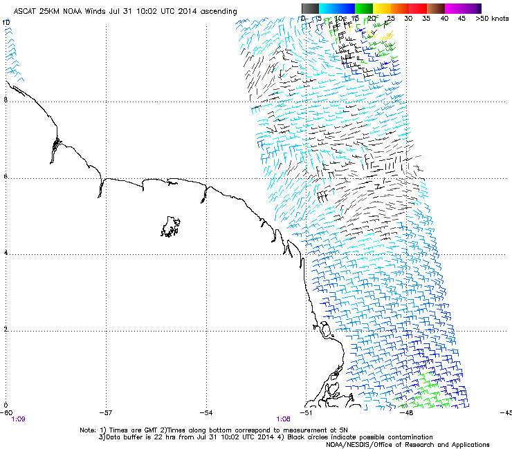
Given the ASCAT missing the convection, this is probably already at storm intensity.
And just checking over the ASCAT passes for the last few days, and noticed that until today there hasn't really been a tight single circulation center, but seemingly two circulations (the main one, and one SW which is now the dying area of convection west of the system), and am thinking that this may have contributed to the lack of convection the last few days, by there being less convergence and thus nothing to keep it sustained.
And just checking over the ASCAT passes for the last few days, and noticed that until today there hasn't really been a tight single circulation center, but seemingly two circulations (the main one, and one SW which is now the dying area of convection west of the system), and am thinking that this may have contributed to the lack of convection the last few days, by there being less convergence and thus nothing to keep it sustained.
0 likes
The above post is not official and should not be used as such. It is the opinion of the poster and may or may not be backed by sound meteorological data. It is not endorsed by any professional institution or storm2k.org. For official information, please refer to the NHC and NWS products.
-
jaxfladude
- Category 5
- Posts: 1249
- Joined: Wed Aug 24, 2005 9:36 pm
- Location: Jacksonville, Fla
Re: ATL: INVEST 93L - Discussion
We have a fighter with this system. Time will tell if this system becomes anything of note.
========
Personal Forecast Disclaimer:
The posts in this forum are NOT official forecast and should not be used as such. They are just the opinion of the poster and may or may not be backed by sound meteorological data. They are NOT endorsed by any professional institution or storm2k.org. For official information, please refer to the NHC and NWS products.
0 likes
Stay safe y'all
-
cycloneye
- Admin
- Posts: 149562
- Age: 69
- Joined: Thu Oct 10, 2002 10:54 am
- Location: San Juan, Puerto Rico
Re: ATL: INVEST 93L - Discussion
From the San Juan NWS: Bring it on!
RECENT SATELLITE IMAGERY INDICATES INVEST 93L HAS DEVELOPED SOME DEEP
CONVECTION IN THE LAST 6 HRS AND THIS HAS PROMPTED NHC TO RAISE
THE GENESIS POTENTIAL TO 60% OR LIKELY CATEGORY. ALL GUIDANCE NOW
PRETTY MUCH ONBOARD INDICATING A WELL-DEFINED MID LEVEL
CIRCULATION POSSIBLE WEAK TROPICAL CYCLONE WILL PASS OVER
NORTHEAST PR SAT EVENING. AN ASCAT PASS AROUND 0111Z SHOWED A FEW
WIND BARBS IN THE 30-35 KT RANGE NORTH OF THE CENTER OF
CIRCULATION. EXPECT A SWATH OF HEAVY RAINS ALONG TRACK OF MID-
LEVEL CIRCULATION AFFECTING THE LEEWARDS...USVI AND NORTHEAST PR
SATURDAY AND SATURDAY EVENING. RAINS EXPECTED TO REACH ST. CROIX
BY 12Z SAT AND SPREAD OVER THE ERN THIRD OF PR AROUND MIDDAY SAT
AND CONTINUE THROUGH MIDNIGHT SAT NIGHT. A 6-HR PERIOD OF VERY
INTENSE RAIFNALL APPEARS LIKELY OVR THESE AREAS. LATEST GFS
SUGGESTS A SWATH OF 4 TO 6 INCHES WILL AFFECT THE USVI. FOR A
6-HR PERIOD RAINFALL AMOUNTS TYPICALLY AVERAGE AROUND FIVE INCHES
SO THINK A RANGE OF THREE TO SEVEN INCHES OF RAIN IS POSSIBLE WITH
THIS SYSTEM WITH THE HIGHEST ACCUMULATIONS OVR NE PR/EL YUNQUE
AREA WHERE BEST OROGRAPHIC ENHANCEMENT IS EXPECTED. REST OF PR
WILL SEE MUCH LESSER AMOUNTS. SHOWERS WILL DIMINISH IN CVRG AND
INTENSITY AFTER 06Z SUN AS SYSTEM DEPARTS AND WINDS AND SFC
CONVERGENCE DIMINISH.
0 likes
Visit the Caribbean-Central America Weather Thread where you can find at first post web cams,radars
and observations from Caribbean basin members Click Here
and observations from Caribbean basin members Click Here
Re: ATL: INVEST 93L - Discussion
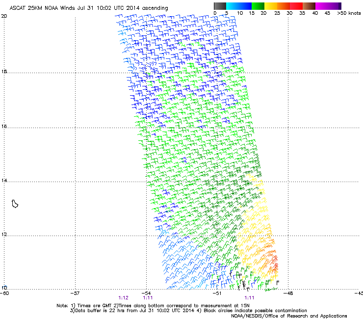
Another look at last night's ASCAT pass which showed plenty of good westerly winds and 30-35 knot winds in the NW quadrant away from the deep convection.
0 likes
-
Gustywind

- Category 5
- Posts: 12334
- Joined: Mon Sep 03, 2007 7:29 am
- Location: Baie-Mahault, GUADELOUPE
TROPICAL WEATHER DISCUSSION
NWS NATIONAL HURRICANE CENTER MIAMI FL
205 AM EDT THU JUL 31 2014
...SPECIAL FEATURES...
A 1010 MB LOW IS CENTERED NEAR 11N48W MOVING W-NW AT 15 KT. THE
LOW LIES WITHIN THE MONSOON TROUGH AXIS AND CONTINUES TO SHOW A
MARGINALLY IMPRESSIVE SATELLITE PRESENTATION. DURING THE PAST
FEW HOURS HOWEVER...A ONCE EXPOSED LOW-LEVEL CIRCULATION CENTER
HAS SEEN A BURST OF SCATTERED MODERATE CONVECTION FORM WITHIN 45
NM OF THE CIRCULATION CENTER. IN ADDITION...EARLIER EVENING
ASCAT PASSES AROUND 31/0022 UTC AND 31/0110 UTC INDICATE A 20 TO
30 KT WIND FIELD SURROUNDING THE LOW WITHIN 90 NM OF CENTER.
PLEASE SEE THE LATEST NHC TROPICAL WEATHER OUTLOOK UNDER AWIPS/
WMO HEADERS MIATWOAT/ABNT20 KNHC FOR MORE DETAILS.
0 likes
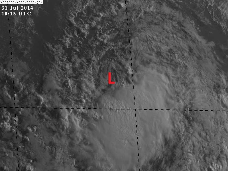
Visible Satellite this morning shows the low pressure center mostly naked again but still a very vigorous circulation. I estimate it to be near 11N & 50.9W, moving still almost due west 18-19 mph.
Last edited by NDG on Thu Jul 31, 2014 5:55 am, edited 1 time in total.
0 likes
Who is online
Users browsing this forum: No registered users and 17 guests