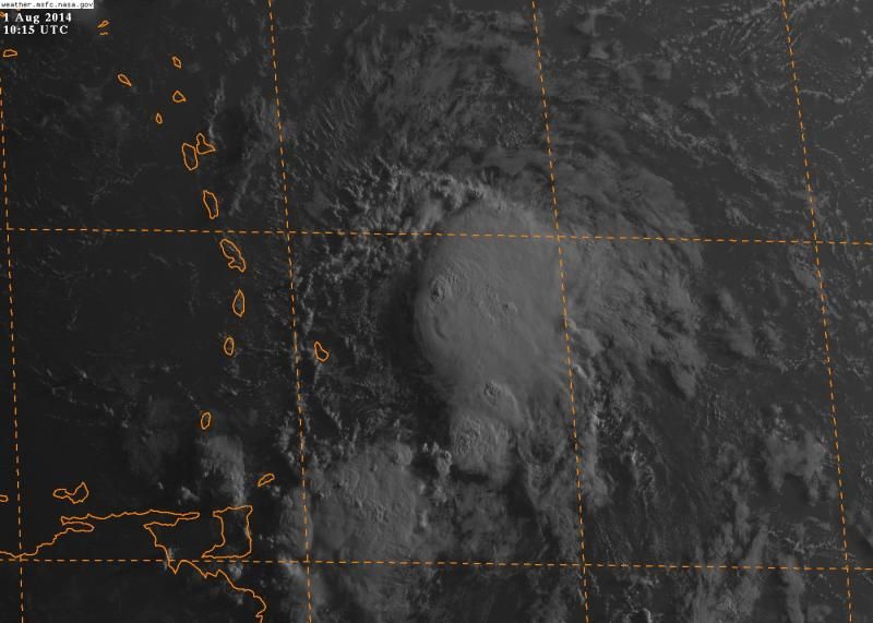
Just veiwed the long loop yes its being affected by shear but i cant agree its now a open wave there is actually a nice tot firing up as i post.
The posts in this forum are NOT official forecast and should not be used as such. They are just the opinion of the poster and may or may not be backed by sound meteorological data. They are NOT endorsed by any professional institution or storm2k.org. For official information, please refer to the NHC and NWS products
ATL: BERTHA - Post-Tropical - Discussion
Moderator: S2k Moderators
-
tropicwatch

- Category 5

- Posts: 3426
- Age: 62
- Joined: Sat Jun 02, 2007 10:01 am
- Location: The Villages, Florida
- Contact:
Re: ATL: BERTHA - Tropical Storm - Discussion
Looks like she will be fighting both dry air and wind shear this morning.

0 likes
Tropicwatch
Agnes 72', Eloise 75, Elena 85', Kate 85', Charley 86', Florence 88', Beryl 94', Dean 95', Erin 95', Opal 95', Earl 98', Georges 98', Ivan 2004', Arlene 2005', Dennis 2005', Ida 2009' Debby 2012' Irma 2017' Michael 2018'
Agnes 72', Eloise 75, Elena 85', Kate 85', Charley 86', Florence 88', Beryl 94', Dean 95', Erin 95', Opal 95', Earl 98', Georges 98', Ivan 2004', Arlene 2005', Dennis 2005', Ida 2009' Debby 2012' Irma 2017' Michael 2018'

The convection is increasing at the center, maybe it starting to get some real meat on it's body
0 likes
Personal Forecast Disclaimer:
The posts in this forum are NOT official forecast and should not be used as such. They are just the opinion of the poster and may or may not be backed by sound meteorological data. They are NOT endorsed by any professional institution or storm2k.org. For official information, please refer to the NHC and NWS products.
The posts in this forum are NOT official forecast and should not be used as such. They are just the opinion of the poster and may or may not be backed by sound meteorological data. They are NOT endorsed by any professional institution or storm2k.org. For official information, please refer to the NHC and NWS products.
-
Gustywind

- Category 5
- Posts: 12334
- Joined: Mon Sep 03, 2007 7:29 am
- Location: Baie-Mahault, GUADELOUPE
000
WTNT33 KNHC 010847
TCPAT3
BULLETIN
TROPICAL STORM BERTHA ADVISORY NUMBER 2
NWS NATIONAL HURRICANE CENTER MIAMI FL AL032014
500 AM AST FRI AUG 01 2014
...BERTHA CONTINUES TOWARD THE LESSER ANTILLES AND THE NORTHEASTERN
CARIBBEAN SEA...
...TROPICAL STORM WARNINGS ISSUED FOR PUERTO RICO AND ADJACENT
ISLANDS...
SUMMARY OF 500 AM AST...0900 UTC...INFORMATION
----------------------------------------------
LOCATION...13.0N 57.0W
ABOUT 170 MI...270 KM E OF BARBADOS
ABOUT 295 MI...470 KM ESE OF MARTINIQUE
MAXIMUM SUSTAINED WINDS...45 MPH...75 KM/H
PRESENT MOVEMENT...WNW OR 290 DEGREES AT 20 MPH...31 KM/H
MINIMUM CENTRAL PRESSURE...1008 MB...29.77 INCHES
0 likes


Re: ATL: BERTHA - Tropical Storm - Discussion
Very clearly on shortwave IR loop during the night, Recon will confirm that it is still a closed circulation and that it is worth naming it Tropical Storm Bertha, that's my story this morning, lol.
0 likes
-
Gustywind
- Category 5
- Posts: 12334
- Joined: Mon Sep 03, 2007 7:29 am
- Location: Baie-Mahault, GUADELOUPE
Tropical Storm Bertha Develops in Atlantic
Courtney Spamer
By Courtney Spamer, Meteorologist
August 01, 2014; 4:50 AM
 http://www.accuweather.com/en/weather-n ... l/31213830
Tropical Storm Bertha has developed in the Atlantic Ocean, making it the second named tropical system in the 2014 Atlantic Hurricane Season.
Early Thursday night, the tropical system strengthened to the point of becoming a tropical storm with sustained winds of 45 mph.
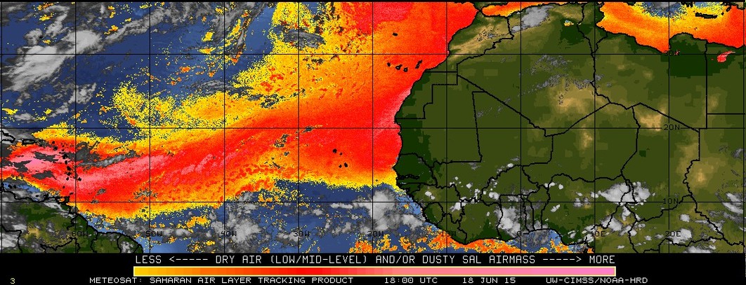
Earlier this week, wind shear and cool waters were inhibiting the system. At midweek, dry air was preventing the system from developing.
Bertha has moved into an area with water temperatures in the lower 80s and lower wind shear, both of which allowed for the system to intensify and become Tropical Storm Bertha.
Wind shear is a zone of strong winds at middle levels of the atmosphere that typically blow from the southwest, west or northwest. These winds can cause an organized tropical system to weaken or prevent one from forming in the first place.
According to AccuWeather.com Tropical Expert Dan Kottlowski, the system has a well-defined, low-level circulation center.
The tropical storm is forecast to take a curved, elliptical path around the high pressure area over the Atlantic, but that exact path will be dependent on the strength of the system.
"A weaker system will track more to the west before making the curved path, while a stronger tropical storm early on could cause the system to curve east of the Leeward Islands," Kottlowski said.
At this point, for the coming weekend, "the Leeward and northern part of the Windward islands, Puerto Rico and the U.S. Virgin Islands are the areas being monitored very closely," Kottlowski added.
The National Hurricane Center has already issued tropical storm watches and warnings for portions of the Lesser Antilles as well as tropical storm watches for Puerto Rico.
Disruptions from the system will tend to be brief over the islands.
"Impact from the system will be locally heavy rains and gusty winds for a 24- to 36-hour period, depending on the track and strength of the system," Kottlowski said.
The timing of the system's showers and thunderstorms would be Friday night in the Leeward and northern Windward islands then the U.S. and British Virgin Islands, and Puerto Rico on Saturday.
While the system may cause minor disruptions for people vacationing in the region, portions of the Caribbean islands are in need of rain. For example, since Jan. 1, 2014, San Juan, Puerto Rico, with about 23 inches of rain has only received about two-thirds of its average for the year so far.
Bertha could track close enough to Bermuda during the middle of next week to bring some rainfall.
The relatively quiet Atlantic tropical season so far in 2014 is not that uncommon. Although the season officially begins on June 1, the most active period does not really get going until mid-August.
It is at this time when the waters across the Atlantic are the warmest, and typically, the dry air and wind shear taper off.
Courtney Spamer
By Courtney Spamer, Meteorologist
August 01, 2014; 4:50 AM
Tropical Storm Bertha has developed in the Atlantic Ocean, making it the second named tropical system in the 2014 Atlantic Hurricane Season.
Early Thursday night, the tropical system strengthened to the point of becoming a tropical storm with sustained winds of 45 mph.
Earlier this week, wind shear and cool waters were inhibiting the system. At midweek, dry air was preventing the system from developing.
Bertha has moved into an area with water temperatures in the lower 80s and lower wind shear, both of which allowed for the system to intensify and become Tropical Storm Bertha.
Wind shear is a zone of strong winds at middle levels of the atmosphere that typically blow from the southwest, west or northwest. These winds can cause an organized tropical system to weaken or prevent one from forming in the first place.
According to AccuWeather.com Tropical Expert Dan Kottlowski, the system has a well-defined, low-level circulation center.
The tropical storm is forecast to take a curved, elliptical path around the high pressure area over the Atlantic, but that exact path will be dependent on the strength of the system.
"A weaker system will track more to the west before making the curved path, while a stronger tropical storm early on could cause the system to curve east of the Leeward Islands," Kottlowski said.
At this point, for the coming weekend, "the Leeward and northern part of the Windward islands, Puerto Rico and the U.S. Virgin Islands are the areas being monitored very closely," Kottlowski added.
The National Hurricane Center has already issued tropical storm watches and warnings for portions of the Lesser Antilles as well as tropical storm watches for Puerto Rico.
Disruptions from the system will tend to be brief over the islands.
"Impact from the system will be locally heavy rains and gusty winds for a 24- to 36-hour period, depending on the track and strength of the system," Kottlowski said.
The timing of the system's showers and thunderstorms would be Friday night in the Leeward and northern Windward islands then the U.S. and British Virgin Islands, and Puerto Rico on Saturday.
While the system may cause minor disruptions for people vacationing in the region, portions of the Caribbean islands are in need of rain. For example, since Jan. 1, 2014, San Juan, Puerto Rico, with about 23 inches of rain has only received about two-thirds of its average for the year so far.
Bertha could track close enough to Bermuda during the middle of next week to bring some rainfall.
The relatively quiet Atlantic tropical season so far in 2014 is not that uncommon. Although the season officially begins on June 1, the most active period does not really get going until mid-August.
It is at this time when the waters across the Atlantic are the warmest, and typically, the dry air and wind shear taper off.
0 likes
-
somethingfunny

- ChatStaff

- Posts: 3926
- Age: 37
- Joined: Thu May 31, 2007 10:30 pm
- Location: McKinney, Texas
She's looking pretty good this morning. Thunderstorms on that northern side now, where forward motion and the pressure gradient will only add to the strength of the winds... the tropical storm warnings for Barbados, St. Lucia, Martinique and Dominica are a good call.
0 likes
I am not a meteorologist, and any posts made by me are not official forecasts or to be interpreted as being intelligent. These posts are just my opinions and are probably silly opinions.
-
tropicwatch
- Category 5
- Posts: 3426
- Age: 62
- Joined: Sat Jun 02, 2007 10:01 am
- Location: The Villages, Florida
- Contact:
Re: ATL: BERTHA - Tropical Storm - Discussion
Peak (10s Avg.) Sfc. Wind 43kts
0 likes
Tropicwatch
Agnes 72', Eloise 75, Elena 85', Kate 85', Charley 86', Florence 88', Beryl 94', Dean 95', Erin 95', Opal 95', Earl 98', Georges 98', Ivan 2004', Arlene 2005', Dennis 2005', Ida 2009' Debby 2012' Irma 2017' Michael 2018'
Agnes 72', Eloise 75, Elena 85', Kate 85', Charley 86', Florence 88', Beryl 94', Dean 95', Erin 95', Opal 95', Earl 98', Georges 98', Ivan 2004', Arlene 2005', Dennis 2005', Ida 2009' Debby 2012' Irma 2017' Michael 2018'
-
tolakram
- Admin

- Posts: 20186
- Age: 62
- Joined: Sun Aug 27, 2006 8:23 pm
- Location: Florence, KY (name is Mark)
Re:
ninel conde wrote:probably was a premature naming.
How so?
Live visible: http://wwwghcc.msfc.nasa.gov/cgi-bin/get-goes?satellite=GOES-E%20HURRICANE&lat=15&lon=-59&info=vis&zoom=1&width=1024&height=768&type=Animation&quality=92&palette=ir1.pal&numframes=5
0 likes
M a r k
- - - - -
Join us in chat: Storm2K Chatroom Invite. Android and IOS apps also available.
The posts in this forum are NOT official forecasts and should not be used as such. Posts are NOT endorsed by any professional institution or STORM2K.org. For official information and forecasts, please refer to NHC and NWS products.

Re:
Alyono wrote:those high winds were during a descent... may not be valid
Morning visible is inconclusive as to whether or not there is a center. Recon is doing a low level invest to confirm that the center still exists
They were already at cruising altitude at h85.
Edit: Never mind, I see what you are saying that they just descended some more.
0 likes
they probably hit the center.
It is VERY weak. Pressure has also risen since yesterday. Bertha is weakening
One should NOT pay attention to convection in these weak systems. Focus on the structure and the low level cloud motions. The low cloud motions indicate less of a circulation than yesterday
It is VERY weak. Pressure has also risen since yesterday. Bertha is weakening
One should NOT pay attention to convection in these weak systems. Focus on the structure and the low level cloud motions. The low cloud motions indicate less of a circulation than yesterday
0 likes
Who is online
Users browsing this forum: No registered users and 16 guests