ATL: BERTHA - Post-Tropical - Discussion
Moderator: S2k Moderators


This should probably go somewhere else, if so, mea culpa, but just in from our ferry folks
REPITO INFORMACION VIAJES ULTIMA EMBARCACION DE FAJARDO A CULEBRA 2:30 PM ULTIMA EMBARCACION CULEBRA A FAJARDO 5:00PM.
REPEAT INFORMATION TRAVEL LAST BOAT FROM FAJARDO TO CULEBRA 2:30 PM LAST BOAT CULEBRA TO FAJARDO 5:00 PM.
REPITO INFORMACION VIAJES ULTIMA EMBARCACION DE FAJARDO A CULEBRA 2:30 PM ULTIMA EMBARCACION CULEBRA A FAJARDO 5:00PM.
REPEAT INFORMATION TRAVEL LAST BOAT FROM FAJARDO TO CULEBRA 2:30 PM LAST BOAT CULEBRA TO FAJARDO 5:00 PM.
0 likes
Re: ATL: BERTHA - Tropical Storm - Discussion
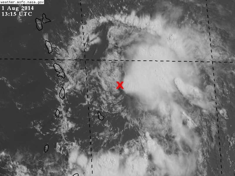
Just a guess but that cloud "band" to the north seems to be an outflow boundary more than anything - looks pretty unimpressive even with the wind...
0 likes
-
wxman57

- Moderator-Pro Met

- Posts: 23175
- Age: 68
- Joined: Sat Jun 21, 2003 8:06 pm
- Location: Houston, TX (southwest)
Re: ATL: BERTHA - Tropical Storm - Discussion
That does appear to be an outflow boundary to the north. LLC looks very poorly-defined - the worst it's looked in the last 4 days. I suspect the strong winds to the north are more due to the SAL outbreak than Bertha's circulation. They aren't even blowing inward toward the center. Could well open up into a wave in the next 6-12 hours.

0 likes
-
cycloneye

- Admin

- Posts: 149565
- Age: 69
- Joined: Thu Oct 10, 2002 10:54 am
- Location: San Juan, Puerto Rico
Re: ATL: BERTHA - Tropical Storm - Discussion
Center moving fast and that is why they missed it.
0 likes
Visit the Caribbean-Central America Weather Thread where you can find at first post web cams,radars
and observations from Caribbean basin members Click Here
and observations from Caribbean basin members Click Here

Yeah I think its pretty clear that any center is to the north of where recon is currently looking at it and also quite possibly true that there is no real center now.
This happens quite alot in weak systems with the convective flare-ups dragging the LLC further north, I seem to recall one system that constantly relocated northwards to such an extent that the models were way out...similar sort of area to what Bertha is in.
Clearly a struggling system right now, I do think its got a good chance of strengthening/redeveloping north of 25N on the way out again but till then its going to have a hard life.
0 likes
Personal Forecast Disclaimer:
The posts in this forum are NOT official forecast and should not be used as such. They are just the opinion of the poster and may or may not be backed by sound meteorological data. They are NOT endorsed by any professional institution or storm2k.org. For official information, please refer to the NHC and NWS products
The posts in this forum are NOT official forecast and should not be used as such. They are just the opinion of the poster and may or may not be backed by sound meteorological data. They are NOT endorsed by any professional institution or storm2k.org. For official information, please refer to the NHC and NWS products
-
SouthDadeFish

- Professional-Met

- Posts: 2836
- Joined: Thu Sep 23, 2010 2:54 pm
- Location: Miami, FL
- Contact:
-
euro6208
Re: ATL: BERTHA - Tropical Storm - Discussion
Can't believe this is a tropical storm first time i looked...Recon truly something essential...
0 likes
Re:
CrazyC83 wrote:How often does a wave occur with 50 kt winds though?
I seem to recall Andrew barely had a center but had very potent winds aloft.
Pre-Alex also had some pretty good winds but lacked a center. I think whatever center is left is going to struggle for a while as it pulls more and more north and buries itself into the dry air that has wrapped round to its north.
NHC will keep it a TC for the time being regardless of what recon shows, just in case a new center is in the process of reforming. If it still is showing little signs on a LLC in 6-12hrs, then thats another matter.
0 likes
Personal Forecast Disclaimer:
The posts in this forum are NOT official forecast and should not be used as such. They are just the opinion of the poster and may or may not be backed by sound meteorological data. They are NOT endorsed by any professional institution or storm2k.org. For official information, please refer to the NHC and NWS products
The posts in this forum are NOT official forecast and should not be used as such. They are just the opinion of the poster and may or may not be backed by sound meteorological data. They are NOT endorsed by any professional institution or storm2k.org. For official information, please refer to the NHC and NWS products
Who is online
Users browsing this forum: No registered users and 19 guests