ATL: BERTHA - Post-Tropical - Discussion
Moderator: S2k Moderators
-
Aric Dunn
- Category 5

- Posts: 21238
- Age: 43
- Joined: Sun Sep 19, 2004 9:58 pm
- Location: Ready for the Chase.
- Contact:
Its quite likely we will see a center reformation north of mona passage or north of the eastern part of DR overnight as does typically occur in this area with weak TC's not dead yet..
Last edited by Aric Dunn on Sat Aug 02, 2014 5:51 pm, edited 2 times in total.
0 likes
Note: If I make a post that is brief. Please refer back to previous posts for the analysis or reasoning. I do not re-write/qoute what my initial post said each time.
If there is nothing before... then just ask
Space & Atmospheric Physicist, Embry-Riddle Aeronautical University,
I believe the sky is falling...
If there is nothing before... then just ask
Space & Atmospheric Physicist, Embry-Riddle Aeronautical University,
I believe the sky is falling...

If Bertha fails to reorganize before tonight and the last advisory issued, are they likely to have it at >60% for the first TWO after?
I believe something of that nature happened with both Mindy in 2003 and Fay in 2008, both of which passed Puerto Rico as tropical waves but formed a closed center as they moved north of the eastern tip of Dominican Republic.
Aric Dunn wrote:Its quite likely we will see a center reformation north of mona passage or north of the eastern part of Hati overnight as does typically occur in this area with weak TC's not dead yet..
I believe something of that nature happened with both Mindy in 2003 and Fay in 2008, both of which passed Puerto Rico as tropical waves but formed a closed center as they moved north of the eastern tip of Dominican Republic.
0 likes
The above post is not official and should not be used as such. It is the opinion of the poster and may or may not be backed by sound meteorological data. It is not endorsed by any professional institution or storm2k.org. For official information, please refer to the NHC and NWS products.
-
ozonepete
- Professional-Met

- Posts: 4743
- Joined: Mon Sep 07, 2009 3:23 pm
- Location: From Ozone Park, NYC / Now in Brooklyn, NY
Re:
Hammy wrote:If Bertha fails to reorganize before tonight and the last advisory issued, are they likely to have it at >60% for the first TWO after?
I would think they'd put it at 50/50 or orange if they decide to kill it but for continuity's sake I have a feeling they won't kill it. The odds are still too strong for regeneration. The only way they kill it is if the 00Z model runs get bearish on it and I don't think that will happen because there's such good vorticity still associated with it and mid level dry air and shear are both dropping now.
0 likes
Re: ATL: BERTHA - Tropical Storm - Discussion
Good chance Bertha may just remain a wave and merge with a frontal boundary east of the Carolinas. I wouldn't give it much chance of becoming a hurricane in 4-5 days. Next advisory by NHC should be the last
Regeneration would be more likely if there were something to regenerate : )
0 likes
-
ozonepete
- Professional-Met
- Posts: 4743
- Joined: Mon Sep 07, 2009 3:23 pm
- Location: From Ozone Park, NYC / Now in Brooklyn, NY
Re: ATL: BERTHA - Tropical Storm - Discussion
Frank2 wrote:Good chance Bertha may just remain a wave and merge with a frontal boundary east of the Carolinas. I wouldn't give it much chance of becoming a hurricane in 4-5 days. Next advisory by NHC should be the last
Regeneration would be more likely if there were something to regenerate : )
Haha c'mon Frank. You know better than that. You've been around here a long time. You could probably give as many examples as I could of TS's that opened into a wave and then regenerated in that area as soon as they passed that island.
0 likes
-
ozonepete
- Professional-Met
- Posts: 4743
- Joined: Mon Sep 07, 2009 3:23 pm
- Location: From Ozone Park, NYC / Now in Brooklyn, NY
Re: ATL: BERTHA - Tropical Storm - Discussion
Not to mention that I see west winds along the northeastern coast of DR as exhibited by cloud motion on the rgb satellite. And numerous hot towers in the convection.
0 likes
-
AJC3

- Admin

- Posts: 4156
- Age: 62
- Joined: Tue Aug 31, 2004 7:04 pm
- Location: Ballston Spa, New York
- Contact:
Re: ATL: BERTHA - Tropical Storm - Discussion
ozonepete wrote:Not to mention that I see west winds along the northeastern coast of DR as exhibited by cloud motion on the rgb satellite. And numerous hot towers in the convection.
Frankly, I'm not seeing that at all. Arc clouds are ripping pretty quickly toward the W or NW everywhere from about 19N northward.
0 likes
-
ozonepete
- Professional-Met
- Posts: 4743
- Joined: Mon Sep 07, 2009 3:23 pm
- Location: From Ozone Park, NYC / Now in Brooklyn, NY
Re: ATL: BERTHA - Tropical Storm - Discussion
AJC3 wrote:ozonepete wrote:Not to mention that I see west winds along the northeastern coast of DR as exhibited by cloud motion on the rgb satellite. And numerous hot towers in the convection.
Frankly, I'm not seeing that at all. Arc clouds are ripping pretty quickly toward the W or NW everywhere from about 19N northward.
Hi AJ! Always good to see you. It was just in the last few frames before sundown that I saw it and I'm not 100% sure. And yes there are arc clouds from collapsing thunderstorms but since more convection is building than collapsing I would think the net result is no weakening of the overall system or more likely some strengthening. It's pretty clear right now from rgb or ir satellite loops that this is generating stronger convection now. Do you think it's over?
0 likes
Regeneration would be more likely if there were something to regenerate : )
Haha c'mon Frank. You know better than that. You've been around here a long time. You could probably give as many examples as I could of TS's that opened into a wave and then regenerated in that area as soon as they passed that island
True Pete, but as the TCD mentioned it barely qualifies - I'll guess the HRD folks are discussing what to do - a deployment costs a lot of funds they don't have...
P.S. I noticed the arc clouds too - quite a few...
0 likes
-
ozonepete
- Professional-Met
- Posts: 4743
- Joined: Mon Sep 07, 2009 3:23 pm
- Location: From Ozone Park, NYC / Now in Brooklyn, NY
Re:
Frank2 wrote:Regeneration would be more likely if there were something to regenerate : )
Haha c'mon Frank. You know better than that. You've been around here a long time. You could probably give as many examples as I could of TS's that opened into a wave and then regenerated in that area as soon as they passed that island
True, but as the TCD mentioned it barely qualifies - I'll guess the HRD folks are discussing what to do - a deployment costs a lot of funds they don't have...
They don't have to deploy - there's no reason to given the strength right now and that it will soon turn north and most of the Bahamas are on the weaker side. It is really only about continuity now. So it's what to do based on the fact that we don't have many reliable ship or buoy obs there yet it's clearly increasing its convection right now and in a favored area for regeneration.
0 likes
-
ozonepete
- Professional-Met
- Posts: 4743
- Joined: Mon Sep 07, 2009 3:23 pm
- Location: From Ozone Park, NYC / Now in Brooklyn, NY
Re:
Frank2 wrote:Regeneration would be more likely if there were something to regenerate : )
Haha c'mon Frank. You know better than that. You've been around here a long time. You could probably give as many examples as I could of TS's that opened into a wave and then regenerated in that area as soon as they passed that island
True Pete, but as the TCD mentioned it barely qualifies - I'll guess the HRD folks are discussing what to do - a deployment costs a lot of funds they don't have...
P.S. I noticed the arc clouds too - quite a few...
Did you see what I told AJC? Arc clouds are produced by collapsing thunderstorms (usually from ingesting dry air) but if there's more new convection developing than dissipating than it means the dry air is being handled and it's not an issue.
0 likes
-
gatorcane

- S2K Supporter

- Posts: 23708
- Age: 48
- Joined: Sun Mar 13, 2005 3:54 pm
- Location: Boca Raton, FL
Saved RGB loop showing arc clouds moving NW on the NW side of the system. The system is building convection still, even at DMIN - I believe it will regenerate and find favorable conditions as it passes East of the Bahamas, where it will gain some strength:

The posts in this forum are NOT official forecast and should not be used as such. They are just the opinion of the poster and may or may not be backed by sound meteorological data. They are NOT endorsed by any professional institution or storm2k.org. For official information, please refer to the NHC and NWS products.
The posts in this forum are NOT official forecast and should not be used as such. They are just the opinion of the poster and may or may not be backed by sound meteorological data. They are NOT endorsed by any professional institution or storm2k.org. For official information, please refer to the NHC and NWS products.
Last edited by gatorcane on Sat Aug 02, 2014 7:21 pm, edited 2 times in total.
0 likes
Re: ATL: BERTHA - Tropical Storm - Discussion
ozonepete wrote:Oh, and put me down for regeneration.
Me too.
0 likes
-
ozonepete
- Professional-Met
- Posts: 4743
- Joined: Mon Sep 07, 2009 3:23 pm
- Location: From Ozone Park, NYC / Now in Brooklyn, NY
Re: ATL: BERTHA - Tropical Storm - Discussion
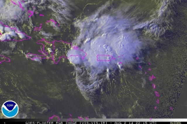
Thanks for the loop gatorcane. You can clearly see the hot towers on that loop but here's a still image to back it up. This doesn't look like a dying system at all.

0 likes
-
AJC3
- Admin
- Posts: 4156
- Age: 62
- Joined: Tue Aug 31, 2004 7:04 pm
- Location: Ballston Spa, New York
- Contact:
Re: ATL: BERTHA - Tropical Storm - Discussion
ozonepete wrote:AJC3 wrote:ozonepete wrote:Not to mention that I see west winds along the northeastern coast of DR as exhibited by cloud motion on the rgb satellite. And numerous hot towers in the convection.
Frankly, I'm not seeing that at all. Arc clouds are ripping pretty quickly toward the W or NW everywhere from about 19N northward.
Hi AJ! Always good to see you. It was just in the last few frames before sundown that I saw it and I'm not 100% sure. And yes there are arc clouds from collapsing thunderstorms but since more convection is building than collapsing I would think the net result is no weakening of the overall system or more likely some strengthening. It's pretty clear right now from rgb or ir satellite loops that this is generating stronger convection now. Do you think it's over?
Likewise! Pretty much summed up my thoughts in a post earlier this afternoon...short answer: no, I don't think it's over.
viewtopic.php?f=59&t=116524&p=2397217&hilit=#p2397217
I don't see it at all anymore.
I looked at high res visible imagery overlaid on a 1 degree LALO grid very closely, and observed the motion of low cloud elements around eastern Hispanola and to the south and southwest of PR as they've peeked out from behind the convective debris. There is no longer any semblance of any westerly component to the motion of these clouds. The best you have now is a due south motion in the area south of PR. Thus, it appears that this is (and likely has been for some time) an open t-wave.
That having been said, with the system slowing it's forward speed and beginning to turn over the next two days, that process, in and of itself, will increase the likelihood of a fairly quick return of some ground-relative westerly component to the wind flow - not to mention the improvement in organization that will occur as the system moves by Hispanola and into an increasingly favorable large scale environment.
Thus, even though it appears to have opened up, I feel pretty strongly that this is temporary.
0 likes
-
ozonepete
- Professional-Met
- Posts: 4743
- Joined: Mon Sep 07, 2009 3:23 pm
- Location: From Ozone Park, NYC / Now in Brooklyn, NY
Re: ATL: BERTHA - Tropical Storm - Discussion
0 likes
-
galaxy401

- Category 5
- Posts: 2446
- Age: 30
- Joined: Sat Aug 25, 2012 9:04 pm
- Location: Casa Grande, Arizona
Yeah I can't detect a rotation in that loop. However, there is a good amount of convection persisting. If it finds a favorable environment, she'll probably redevelop quickly.
The posts in this forum are NOT official forecast and should not be used as such. They are just the opinion of the poster and may or may not be backed by sound meteorological data. They are NOT endorsed by any professional institution or storm2k.org. For official information, please refer to the NHC and NWS products.
The posts in this forum are NOT official forecast and should not be used as such. They are just the opinion of the poster and may or may not be backed by sound meteorological data. They are NOT endorsed by any professional institution or storm2k.org. For official information, please refer to the NHC and NWS products.
0 likes
Got my eyes on moving right into Hurricane Alley: Florida.
Could be at the mid levels but I see a wee bit of curling on the San Juan radar over NE Dominican Republic (unfortunately out of recons reach)
0 likes
The above post is not official and should not be used as such. It is the opinion of the poster and may or may not be backed by sound meteorological data. It is not endorsed by any professional institution or storm2k.org. For official information, please refer to the NHC and NWS products.
Who is online
Users browsing this forum: No registered users and 7 guests