AF304--
This will be my last update here for this recon flight, so here's an open invitation for someone to continue recon updates!VORTEX DATA MESSAGE
Product: Air Force Vortex Message (URNT12 KNHC)
Transmitted: 4th day of the month at 05:23Z
Aircraft: Air Force Aircraft (Last 3 digits of the tail number are 304)
Storm Number & Year: 03L in 2014
Storm Name: Bertha (flight in the North Atlantic basin)
Mission Number: 9
Observation Number: 19
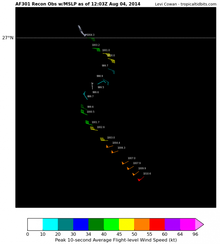
A. Time of Center Fix: 4th day of the month at 5:06:50Z
B. Center Fix Coordinates: 25°11'N 73°28'W (25.1833N 73.4667W) (View map)
B. Center Fix Location: 243 miles (390 km) to the E (88°) from Nassau, Bahamas.
C. Minimum Height at Standard Level: 1,473m (4,833ft) at 850mb
D. Estimated (by SFMR or visually) Maximum Surface Wind: 51kts (~ 58.7mph)
E. Location of the Estimated Maximum Surface Wind: 20 nautical miles (23 statute miles) to the NNE/NE (34°) of center fix
F. Maximum Flight Level Wind Inbound: From 144° at 50kts (From the SE at ~ 57.5mph)
G. Location of Maximum Flight Level Wind Inbound: 23 nautical miles (26 statute miles) to the NE (36°) of center fix
H. Minimum Sea Level Pressure: 1005mb (29.68 inHg)
I. Maximum Flight Level Temp & Pressure Altitude Outside Eye: 16°C (61°F) at a pressure alt. of 1,519m (4,984ft)
J. Maximum Flight Level Temp & Pressure Altitude Inside Eye: 19°C (66°F) at a pressure alt. of 1,526m (5,007ft)
K. Dewpoint Temp (collected at same location as temp inside eye): 17°C (63°F)
K. Sea Surface Temp (collected at same location as temp inside eye): Not Available
L. Eye Character: Not Available
M. Eye Shape: Not Available
N. Fix Determined By: Penetration, Radar, Wind, Pressure and Temperature
N. Fix Level: 850mb
O. Navigational Fix Accuracy: 0.02 nautical miles
O. Meteorological Accuracy: 1.5 nautical miles
Remarks Section - Remarks That Were Decoded...
Maximum Flight Level Wind: 52kts (~ 59.8mph) which was observed 80 nautical miles (92 statute miles) to the SE (142°) from the flight level center at 3:32:30Z
Remarks Section - Additional Remarks...
CTR DROPSONDE SFC WIND 210/14
Code: Select all
000
URNT12 KNHC 040523
VORTEX DATA MESSAGE   AL032014
A. 04/05:06:50Z
B. 25 deg 11 min N
  073 deg 28 min W
C. 850 mb 1473 m
D. 51 kt
E. 034 deg 20 nm
F. 144 deg 50 kt
G. 036 deg 23 nm
H. 1005 mb
I. 16 C / 1519 m
J. 19 C / 1526 m
K. 17 C / NA
L. NA
M. NA
N. 12345 / 8
O. 0.02 / 1.5 nm
P. AF304 0903A BERTHA             OB 19
MAX FL WIND 52 KT 142 / 80 NM 03:32:30Z
CTR DROPSONDE SFC WIND 210/14
;
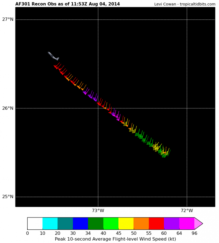
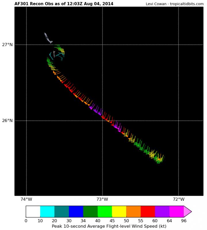
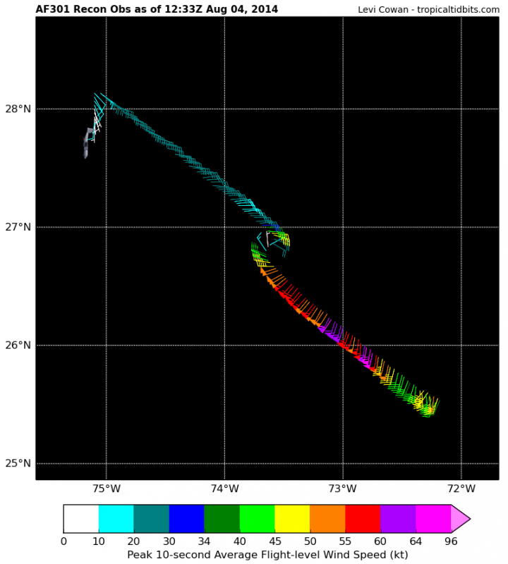
Observation 49
-- Recon going southwest.
Code: Select all
000
URNT15 KNHC 040523
AF304 0903A BERTHA             HDOB 49 20140804
051400 2454N 07339W 8433 01584 0119 +165 +157 285032 032 037 001 00
051430 2453N 07340W 8432 01586 //// +160 //// 283030 031 035 000 01
051500 2452N 07341W 8432 01585 0120 +164 +163 281031 031 034 000 01
051530 2452N 07341W 8432 01585 0120 +162 //// 279032 032 034 000 01
051600 2450N 07344W 8432 01590 0123 +166 +153 278032 033 032 000 00
051630 2449N 07345W 8433 01589 0123 +168 +148 280033 033 030 000 00
051700 2448N 07346W 8434 01589 0128 +163 +154 280033 033 028 000 00
051730 2447N 07347W 8430 01595 0131 +160 +155 280032 032 029 000 00
051800 2446N 07348W 8435 01588 0133 +156 +155 283031 032 029 000 01
051830 2445N 07349W 8435 01589 0134 +156 +153 282031 031 029 000 01
051900 2444N 07350W 8433 01590 0130 +164 +149 282030 030 027 000 00
051930 2443N 07351W 8433 01595 0131 +168 +150 279029 030 028 000 00
052000 2442N 07352W 8432 01597 0133 +164 +150 282028 029 030 000 00
052030 2441N 07354W 8436 01593 0135 +160 +152 284028 029 029 000 00
052100 2440N 07355W 8433 01597 0138 +159 +153 286029 030 028 000 00
052130 2439N 07356W 8433 01597 0139 +159 +146 286030 030 027 000 00
052200 2438N 07357W 8432 01600 0138 +164 +140 283029 030 027 000 00
052230 2437N 07358W 8434 01597 0139 +160 +153 280030 030 027 000 00
052300 2435N 07359W 8432 01601 0138 +161 +157 277030 030 028 000 00
052330 2434N 07400W 8433 01598 0138 +165 +156 275029 030 027 000 00
$$
;
[img] [/img]
DROPSONDE #21
-- This was a center drop. 1005 millibar pressure at the surface acquired!
Code: Select all
000
UZNT13 KNHC 040523
XXAA  54058 99252 70735 08053 99005 27218 21014 00044 26815 21016
92731 22202 23509 85467 19423 28502 88999 77999
31313 09608 80506
61616 AF304 0903A BERTHA             OB 21
62626 CENTER MBL WND 21515 AEV 07520 DLM WND 24009 004844 WL150 2
1016 084 REL 2517N07346W 050651 SPG 2518N07346W 050905 =
XXBB  54058 99252 70735 08053 00005 27218 11947 23200 22890 22046
33850 19423 44844 182//
21212 00005 21014 11976 21016 22949 21511 33915 25508 44885 29511
55855 26001 66844 29004
31313 09608 80506
61616 AF304 0903A BERTHA             OB 21
62626 CENTER MBL WND 21515 AEV 07520 DLM WND 24009 004844 WL150 2
1016 084 REL 2517N07346W 050651 SPG 2518N07346W 050905 =
;